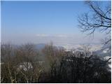
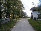
 | Šmartno - Šmarna gora (Šmartinska way)
Šmarna gora is a 669 m peak northwest of Slovenia's capital. From the summit, with its restaurant and church, there is a beautiful view over Gore...
50 min |
 | Šmartno - Šmarna gora (Partizanska way)
Šmarna gora is a 669 m peak northwest of Slovenia's capital. From the summit, with its restaurant and church, there is a beautiful view over Gore...
45 min |
 | Spodnje Dobeno - Rašica (Vrh Staneta Kosca)
Vrh Staneta Kosca, better known as Rašica, is located north of Ljubljana, more precisely above the villages of Rašica and Dobeno. From the summit...
50 min |
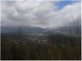
 | Kranj (Kalvarija) - Šmarjetna gora (by road)
Šmarjetna gora is a panoramic peak rising above Kranj. From the summit, where the Church of St. Margaret and the Hotel Bellevue stand, a beautifu...
40 min |
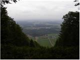
 | Preval - Toško Čelo
Toško Čelo is a 590-metre hill above the village of the same name. From the summit, or slightly below it, a beautiful view opens over part of Lju...
35 min |
 | Ljubljanica - Kožljek
Kožljek is a 788 m high peak located west of Koren, more precisely above the village of Samotorica. From the summit, where there are several benc...
45 min |
 | Briše - Koreno
Koreno (also known as Korena) is a 729 m high hill located north of Horjul. From the summit, which features a large cross, the church of St. Moho...
50 min |
 | Sora - Hom (footpath)
Hom is a 715 m high peak that rises steeply southwest of the village of Sora. From the summit, which is partly forested, there is a beautiful vie...
50 min |
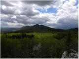
 | Gabrje - Limbarska gora (footpath)
Limbarska gora is located northeast of Moravče. From the summit, there is a beautiful view of the surrounding peaks, and in good weather, the Kam...
45 min |
 | Kuren - Koča na Planini nad Vrhniko
Planina nad Vrhniko is for Vrhnika locals something like Šmarna gora for those from Ljubljana. It is 733 m high, reachable by several paths from ...
45 min |
 | Katarija - Sveti Miklavž above Sava
The Church of St. Miklavž is situated on a panoramic hill south of Moravče. From the summit, there is a beautiful view toward the nearby Limbarsk...
45 min |
 | Kuren - Ulovka
Ulovka is a peak between Zaplana and Zavetišče na Planini nad Vrhniko. From the summit, to which ski lifts run, there is a nice view to the north...
50 min |
 | Vratca - Škabrijel
Škabrijel is a hill northeast of the town of Gorica. Since the vegetation on the summit was cleared and a tall metal observation tower was erecte...
40 min |
| Kekec - Škabrijel
Škabrijel is a hill northeast of the town of Gorica. Since the vegetation on the summit was cleared and a tall metal observation tower was erecte...
50 min |
 | Prevala - Škabrijel
Škabrijel is a hill northeast of the town of Gorica. Since the vegetation on the summit was cleared and a tall metal observation tower was erecte...
50 min |
 | Dobrič - Gora Oljka
Gora Oljka is a hill located east of Šmartno ob Paki. On the summit stands the Church of the Holy Cross, built in the mid-18th century. Just a fe...
50 min |
 | Dobrič (Vedet) - Gora Oljka (via Rogeljšek)
Gora Oljka is a hill located east of Šmartno ob Paki. On the summit stands the Church of the Holy Cross, built in the mid-18th century. Just a fe...
40 min |
| Dobrič (Vedet) - Gora Oljka (via Brezovec)
Gora Oljka is a hill located east of Šmartno ob Paki. On the summit stands the Church of the Holy Cross, built in the mid-18th century. Just a fe...
50 min |
 | Migojnice - Dom na Bukovici
The mountain hut Dom na Bukovici is situated just a few meters below the summit of the forested Bukovica. From the hut, near which there is a lar...
45 min |
 | Zabukovica - Dom na Bukovici
The mountain hut Dom na Bukovici is situated just a few meters below the summit of the forested Bukovica. From the hut, near which there is a lar...
45 min |
 | Kasaze - Dom na Bukovici
The mountain hut Dom na Bukovici is situated just a few meters below the summit of the forested Bukovica. From the hut, near which there is a lar...
45 min |
 | Matke (Zahom) - Dragov dom na Homu
Dragov dom is located on a scenic hill south of Šempeter. From the summit, where there is also the Church of St. Magdalena, there is a fine panor...
35 min |
 | Gora - Trstelj
Trstelj is the highest peak in the ridge of Črni hribi. From the spacious summit, which has TV transmitters, the view is divided. From the north ...
50 min |
 | Lipa - Trstelj
Trstelj is the highest peak in the ridge of Črni hribi. From the spacious summit, which has TV transmitters, the view is divided. From the north ...
40 min |
 | Železna vrata - Trstelj
Trstelj is the highest peak in the ridge of Črni hribi. From the spacious summit, which has TV transmitters, the view is divided. From the north ...
35 min |
 | Košnica - Veliki Slomnik
Veliki Slomnik is a peak located between Košnica pri Celju and Liboje. The summit has a logbook box, but due to the surrounding forest, there are...
40 min |
 | Liboje - Veliki Slomnik
Veliki Slomnik is a peak located between Košnica pri Celju and Liboje. The summit has a logbook box, but due to the surrounding forest, there are...
45 min |
 | Košnica - Hom above Celje
Hom is a forest-covered peak located north of Košnica pri Celju. The summit features a logbook box and a small bench....
40 min |
 | Jakob pri Šentjurju - Rifnik
Rifnik is a 568-meter-high peak situated south of Šentjur pri Celju. The summit, known for its archaeological site, offers nice views towards Šen...
45 min |
 | Galicija - Planinski dom Šentjungert
The mountain hut is located just a few meters below the summit of Gora, where the Church of St. Kunigunda stands; it was built in the 14th centur...
45 min |
 | border crossing Lipica - Kokoš (steep way)
The Koča na Kokoši mountain hut is located on Jirmanec peak, just 5 minutes from the forested Kokoš. From the summit, situated south of Lokavsko ...
50 min |
 | Lipica (Škibini) - Kokoš
The Koča na Kokoši mountain hut is located on Jirmanec peak, just 5 minutes from the forested Kokoš. From the summit, situated south of Lokavsko ...
50 min |
 | Pesek / Pese - Kokoš
The Koča na Kokoši mountain hut is located on Jirmanec peak, just 5 minutes from the forested Kokoš. From the summit, situated south of Lokavsko ...
40 min |
 | Grozzana / Gročana - Kokoš
The Koča na Kokoši mountain hut is located on Jirmanec peak, just 5 minutes from the forested Kokoš. From the summit, situated south of Lokavsko ...
40 min |
 | Vilenica - Stari tabor
Stari Tabor is a panoramic peak located west of Divača, north of Lokev, and south of the village of Povir. From the summit, which has a stamp and...
45 min |
 | Podpeč - Kamen vrh
Kamen Vrh is a panoramic hill located on the northern edge of Mala Gora. From the summit, surrounded by low bushes, there are fine views of parts...
50 min |
 | Šober (Log) - Tojzlov vrh
Tojzlov vrh is a forested hill on the eastern part of Kozjak. On the summit stands a small stone NOB monument and, more recently, also a summit l...
50 min |
 | Sveta Trojica - Murovica
Murovica is a popular excursion point, accessible from the Posavje side, Domžale, or the Moravška Valley. On the summit there is a bench and a lo...
45 min |
 | Vitovlje - Vitovski hrib (by road)
Vitovski hrib is a 604-meter-high hill located north of the village Vitovlje in the Vipava Valley. From the summit, where there is a church dedic...
30 min |
 | Vitovlje - Vitovski hrib (west path)
Vitovski hrib is a 604-meter-high hill located north of the village Vitovlje in the Vipava Valley. From the summit, where there is a church dedic...
40 min |
 | Vitovlje - Vitovski hrib (via Vitovlje Lake)
Vitovski hrib is a 604-meter-high hill located north of the village Vitovlje in the Vipava Valley. From the summit, where there is a church dedic...
40 min |
 | Velika Zaka (Bled) - Mala Osojnica (along Ojstrica)
Mala Osojnica is a 691-meter-high peak rising above Lake Bled near Velika Zaka. It is considered the most popular spot for photographers, as all ...
40 min |
 | Preval Prosca - Visoki hrib
Visoki hrib is a 602-meter-high hill located south of Polhov Gradec. From the summit, which is partly overgrown with forest, a beautiful view ope...
50 min |
 | Legastja - Sveti Florijan (Tehovec)
The Church of St. Florijan is a subsidiary church located in the village of Tehovec above Medvode. From the church, first mentioned in 1548, a ni...
50 min |
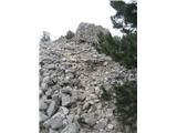
 | Beli Potok at Frankolovo - Lindek Castle
Lindek Castle, first mentioned in 1264, is located on Grajski hrib (Castle Hill), north of Frankolovo. From the summit, where only ruins of the f...
45 min |
 | Prelože pri Lokvi - Veliko Gradišče
Veliko Gradišče is a 742-meter-high peak south of the village Lokev on the Karst and east of Kokoš. From the summit, marked by a concrete boulder...
45 min |
 | Kamnik - Castle Stari grad Kamnik
Stari grad Kamnik, formerly known as Zgornji grad (Oberstain), is located on a scenic hill east of Kamnik called Krniška gora. Today, only ruins ...
35 min |
 | Špitalič pri Slovenskih Konjicah - Babček
Babček is an indistinct peak on the hiking trail between Konjiška gora and Boč. An asphalt road runs practically right below the summit. There ar...
50 min |
 | Radlje ob Dravi - Castle Stari grad above Radlje ob Dravi (Mahrenberg)
Stari grad above Radlje ob Dravi (Mahrenberg) is situated on a hill north of Radlje ob Dravi. From the partly renovated ruins, a nice view opens ...
40 min |
 | Zreče (Terme Zreče) - Brinjeva gora (above Zreče) (on PP1)
Brinjeva gora is a prominent hill situated between Zreče and Oplotnica. It is known for several churches located along its entire ridge. Several ...
45 min |
| Zreče (Terme Zreče) - Brinjeva gora (above Zreče) (via farm Pudgrošek)
Brinjeva gora is a prominent hill situated between Zreče and Oplotnica. It is known for several churches located along its entire ridge. Several ...
50 min |
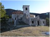
 | Oplotnica - Sveti Mohor (Lačna Gora)
The Church of St. Mohor and Fortunat is situated on a 602-meter-high hill above the settlement Lačna Gora. In front of the church there is a logb...
45 min |
 | Ljubnica - Golek (zgornja pot)
Golek is a 769-meter-high peak located northwest of Zreče. The summit has a logbook box with book and stamp, plus a bench; a short distance (a fe...
45 min |
 | Zreče (Terme Zreče) - Golika
Golika is a 609-meter-high peak on Brinjeva gora, on which stands the church of St. Neža....
50 min |
 | Gleichenberg Dorf - Gleichenberger Kogel
Gleichenberger Kogel is a 598-meter-high mountain of volcanic origin located above Bad Gleichenberg in Styria....
50 min |
 | Straßengel - Frauenkogel (path no. 1)
Frauenkogel is a 683-meter-high hill in the western part of the Graz mountains in Steiermark.The hill is located not far northwest of Graz.On the...
45 min |