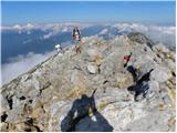
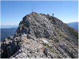
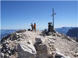
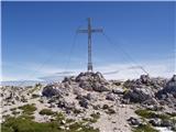
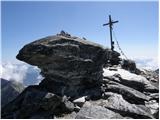
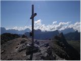
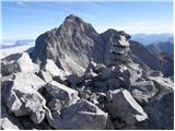
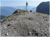
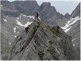
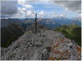
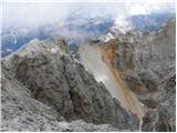
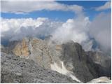
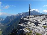
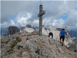
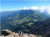
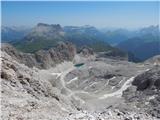
 | Vršič - Prisank / Prisojnik (ridge way)
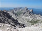
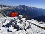
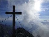
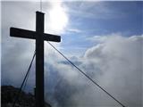
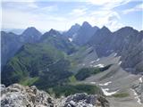
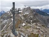
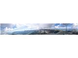
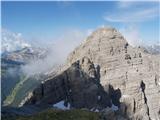
Prisank (also known as Prisojnik) is a 2,547-meter-high mountain situated above the Mlinarica, Krnica, and Suha Pišnica valleys. From the summit,...
3 h 30 min |
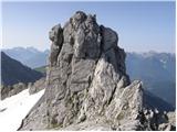
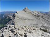
| Vršič - Prisank / Prisojnik (Kopiščarjeva pot)
Prisank (also known as Prisojnik) is a 2,547-meter-high mountain situated above the Mlinarica, Krnica, and Suha Pišnica valleys. From the summit,...
3 h 50 min |
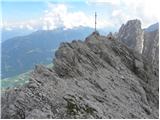
| Erjavčeva koča na Vršiču - Prisank / Prisojnik (Kopiščarjeva pot)
Prisank (also known as Prisojnik) is a 2,547-meter-high mountain situated above the Mlinarica, Krnica, and Suha Pišnica valleys. From the summit,...
4 h |
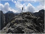
| Erjavčeva koča na Vršiču - Prisank / Prisojnik (ridge path)
Prisank (also known as Prisojnik) is a 2,547-meter-high mountain situated above the Mlinarica, Krnica, and Suha Pišnica valleys. From the summit,...
3 h 45 min |
 | Vršič - Prisank / Prisojnik (via Kajzljeva škrbina)
Prisank (also known as Prisojnik) is a 2,547-meter-high mountain situated above the Mlinarica, Krnica, and Suha Pišnica valleys. From the summit,...
4 h 30 min |
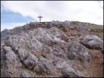
 | Trate / Johannsenruhe - Hochstuhl/Stol (climbing way)
Stol is, at 2,236 m, the highest peak in the Karawanks. From the summit, which has a registration box and stamp, a beautiful view opens onto the ...
3 h 20 min |
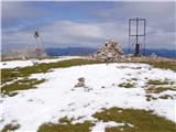
 | Dom pod Storžičem - Storžič (through Žrelo)
Storžič is a 2132 m high mountain located in the western part of the Kamnik-Savinja Alps. From the summit, where there is a cross, a beautiful vi...
3 h |
 | Dom pod Storžičem - Storžič (via Psica)
Storžič is a 2132 m high mountain located in the western part of the Kamnik-Savinja Alps. From the summit, where there is a cross, a beautiful vi...
3 h 45 min |
 | Koschutahaus - Koschutnikturm (Košutnikov turn) (ÖTK Steig Neu)
Košutnikov Turn is the highest peak in Košuta, the longest Slovenian ridge. The summit offers a beautiful view of the entire ridge. Austria and t...
2 h 45 min |
 | Pecol - Jôf di Montasio/Montaž (over Pipan's ladder)
Montaž is one of the most imposing and, at 2,753 m, the second-highest mountain in the Julian Alps. Its authentic Slovenian name is Špik nad Poli...
3 h 30 min |
 | Pecol - Jôf di Montasio/Montaž (via Findenegg couloir)
Montaž is one of the most imposing and, at 2,753 m, the second-highest mountain in the Julian Alps. Its authentic Slovenian name is Špik nad Poli...
3 h 45 min |
 | Nassfeld - Creta di Aip / Trogkofel (Uiberlacher Steig)
Veliki Koritnik / Creta di Aip / Trogkofel is the highest peak in the Mokrine / Nassfeld pass area. The mountain has a gentle summit from which s...
4 h 30 min |
| Nassfeld - Creta di Aip / Trogkofel (Via Ferrata Crete Rosse)
Veliki Koritnik / Creta di Aip / Trogkofel is the highest peak in the Mokrine / Nassfeld pass area. The mountain has a gentle summit from which s...
4 h 30 min |
 | Parking place below Nassfeld - Monte Cavallo / Rosskofel (by east ridge)
Konjski Špik / Monte Cavallo di Pontebba / Rosskofel is a 2,240-meter-high and highly panoramic mountain in the main ridge of the Carnic Alps in ...
3 h 30 min |
 | Sporthotel Maltatal - Großer Hafner
Großer Hafner, at 3076 m, is the highest peak of the Hafner group. From the summit, where a cross stands, there is a nice view of the mentioned g...
4 h 30 min |
 | Prebersee - Roteck
Roteck is a 2742 m high peak located north of Tamsweg in the heart of the Lower Tauern. From the summit, where a cross stands, there is a nice vi...
4 h |
 | Pecol - Cima di Terrarossa (Leva)
Špik Hude police is a 2431-meter-high panoramic peak (new LiDAR measurement; this height will also be shown on newer maps, while older maps still...
4 h 30 min |
 | Piano Fiscalino / Fischleinboden - Monte Paterno (Ferrata De Luca-Innerkofler)
Monte Paterno is a 2744-meter-high panoramic peak. From the top, there is a breathtaking view in all directions, especially the Tre Cime to the w...
4 h 10 min |
 | Rifugio Bai de Dones - Averau (via Rifugio Cinque Torri)
Averau is a 2,649 m peak situated between the Alpine passes Passo di Giau and Passo Falzarego (southwest of Cortina d'Ampezzo). The summit, marke...
2 h 45 min |
| Rifugio Bai de Dones - Averau (Trincee)
Averau is a 2,649 m peak situated between the Alpine passes Passo di Giau and Passo Falzarego (southwest of Cortina d'Ampezzo). The summit, marke...
3 h |
 | Rifugio Tolazzi - Monte Capolago / Seekopf
Monte Capolago / Seekopf is a highly panoramic mountain located on the Austria-Italy border directly above Lake Wolayersee. From the summit there...
3 h 45 min |
 | Lienzer Dolomitenhütte - Große Sandspitze (Ari Schübel)
Große Sandspitze, at 2772 meters, is the highest peak of the Lienz Dolomites. From the summit, which has a summit register box, a breathtaking vi...
3 h 45 min |
 | Lienzer Dolomitenhütte - Teplitzer Spitze
Teplitzer Spitze is a 2613-meter-high mountain situated southwest of Lake Laserzsee. From its somewhat spacious summit, a nice view opens up on t...
3 h |
 | Lienzer Dolomitenhütte - Laserzkopf
Laserzkopf is a 2718-meter-high mountain situated near the highest peak of the Lienz Dolomites. From its summit, which has a cross, a nice view o...
3 h 30 min |
 | Lienzer Dolomitenhütte - Galitzenspitzen
Galitzenspitzen is a 2710-meter-high mountain situated on the ridge between Roter Turm and the highest peak of the Lienz Dolomites, Große Sandspi...
4 h |
 | Lienzer Dolomitenhütte - Große Gamswiesenspitze (Normalweg)
Große Gamswiesenspitze is a 2,488-meter-high mountain located in the heart of the Lienz Dolomites. From the summit, which features a summit logbo...
3 h 30 min |
 | Lienzer Dolomitenhütte - Kleine Gamswiesenspitze
Kleine Gamswiesenspitze is a steep and sharp mountain located near the larger Große Gamswiesenspitze. From its precipitous summit, there is a bea...
3 h 30 min |
 | Plockenpass - Creta di Collinetta / Cellon (Via ferrata Steinberger Weg)
Creta di Collinetta / Cellon is a 2,238-meter-high mountain located west of the Plöcken Pass. From the summit, which features a cross, there is a...
3 h |
 | Pecol - Foronon del Buinz / Špik nad Nosom (Ceria Merlone)
Špik nad Nosom is a 2,531 m high mountain located in the ridge between Montaž and Viš. From its rocky summit on a clear day, views open up to the...
3 h 45 min |
 | Alba di Canazei - Colac (path 646)
Colac is a 2715-meter-high mountain located on the western side of the Marmolada mountain group. From the summit, which features a cross, there i...
4 h |
 | Passo Tre Croci - Cristallino d'Ampezzo
Cristallino d'Ampezzo is a 3008-meter-high mountain in the Cristallo group. It is very popular because a cable car reaches almost 3000 meters.Fro...
3 h 40 min |
 | La Crusc - Lavarella (via Ju dla Crusc)
Lavarella (also La Varella) is the second-highest peak in the Lavarella group. From the summit, which has a cross, there are excellent views of t...
4 h |
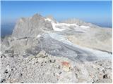
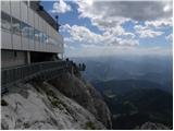 | Türlwandhütte - Hunerkogel
Hunerkogel is a 2,685-meter peak above the Schladming Glacier. From the summit there are beautiful views of the peaks above the glacier, and the ...
4 h |
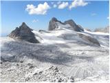
 | Türlwandhütte - Kleiner Koppenkarstein (via Hunerscharte)
Kleiner Koppenkarstein is a 2,832-meter peak in the Dachstein mountain group. This indistinct summit is located on the Koppenkarstein ridge above...
4 h 15 min |
 | Türlwandhütte - Kleiner Gjaidstein (via Hunerscharte)
Kleiner Gjaidstein is a 2735-meter-high peak in the Dachstein mountain group. The summit is situated on the ridge between the glaciers Schladming...
4 h 30 min |
 | Malga Fosse - Cima Vezzana (Via Ferrata Bolver Lugli)
Cima di Vezzana is the highest peak in the Pale di San Martino mountain group at 3,192 meters. From the summit there is a very nice view over muc...
4 h 30 min |
 | Malga Fosse - Il Nuvolo (Via Ferrata Bolver Lugli)
Il Nuvolo is a 3,075-meter-high peak in the Pale di San Martino mountain group. The mountain is located above the Valle dei Cantoni valley, right...
4 h |
 | La Crusc - L'Ciaval / Kreuzkofel
L'Ciaval / Kreuzkofel is a 2,907-meter-high mountain in the Lavarella group. The mountain and the entire ridge it's located in are recognizable b...
3 h |
 | La Crusc - Sasso delle Dieci / Zehnerspitze
Sasso delle Dieci / Zehnerspitze is a 3,028-meter-high mountain rising steeply above Val Badia valley. Sasso delle Dieci is the highest peak in t...
3 h 45 min |
 | Zettersfeld - Schleinitz (Klettersteig)
Schleinitz is a 2,905-meter-high peak in the southern part of the Schober mountain group. From the summit there is a very nice view of all the ma...
4 h 30 min |
 | Landro - Monte Piano (Via Ferrata Bilgeri)
Monte Piano (Toblacher Kreuz) is a 2,305-meter-high mountain located on the northwestern edge of the Monte Piana plateau. Near the summit there a...
3 h |
 | Passo di Costalunga / Karerpass - Roda di Vael / Rotwand (via Passo dal Vaiolon)
Roda di Vael (German: Rotwand) is a 2,806-meter-high mountain in the Catinaccio (Rosengarten) group. The mountain is recognizable mainly by its s...
4 h |
 | Passo di Costalunga / Karerpass - Cima Latemar / Latemarspitze
Cima Latemar (also Schenon Latemar, German: Latemarspitze) is a 2,800-meter-high peak in the Latemar mountain group. From the summit, where a lar...
3 h 40 min |
| Passo di Costalunga / Karerpass - Cima Latemar / Latemarspitze (via Malga Vallace)
Cima Latemar (also Schenon Latemar, German: Latemarspitze) is a 2,800-meter-high peak in the Latemar mountain group. From the summit, where a lar...
3 h 50 min |
 | Rifugio Gardeccia - Catinaccio d'Antermoia / Kesselkogel
Catinaccio d'Antermoia (German: Kesselkogel, Ladin: Antermoa) is, at 3004 meters, the highest peak and only three-thousander in the Catinaccio (R...
3 h 30 min |
 | Rifugio Gardeccia - Catinaccio d'Antermoia / Kesselkogel (via Passo di Antermoia)
Catinaccio d'Antermoia (German: Kesselkogel, Ladin: Antermoa) is, at 3004 meters, the highest peak and only three-thousander in the Catinaccio (R...
4 h |
 | Pian dei Spiriti - Cima Cadin Nord Est (Via Ferrata Ceria Merlone)
Cima Cadin Nord Est is a 2,788-meter-high peak in the Cadini di Misurina mountain group east of Misurina Pass. From the summit there is a very ni...
3 h 20 min |
 | Passo Campolongo - Boeseekofel / Piz da Lech
Piz da Lech (German: Boeseekofel) is a 2,911-meter-high peak in the Sella mountain group. From the summit, where there is a cross with a logbook ...
3 h 10 min |
 | Passo Campolongo - Piz Lech Dlace (Via Ferrata Vallon)
The peak Piz Lech Dlace (German: Eisseespitze, Italian: Piz Lago Gelato) is located above Lake Lech Dlace (German: Eissee, Italian: Lago Gelato) ...
4 h |
 | Plöckenpass - Creta di Collina / Kollinkofel (path 171)
Creta di Collina (German: Kollinkofel) is a 2,691-meter-high mountain in the Carnic Alps. In the immediate surroundings of the mountain, there ar...
4 h |
 | Plöckenpass - Creta di Collina / Kollinkofel (via Cresta Verde)
Creta di Collina (German: Kollinkofel) is a 2,691-meter-high mountain in the Carnic Alps. In the immediate surroundings of the mountain, there ar...
4 h |
 | Passo Campolongo - Cresta Strenta (Via Ferrata Vallon)
Cresta Strenta is a less prominent peak north of Piz Boè. From the summit there is a superb view over much of the Dolomites. At 3,124 meters, Cre...
4 h 25 min |
 | Edelweiss - Monte Volaia / Wolayer Kopf (path 176)
Italian Monte Volaia, German Wolayer Kopf, is a 2470-meter-high peak in the main ridge of the Carnic Alps west of the highest peak Monte Coglians...
3 h 45 min |
| Collina - Monte Volaia / Wolayer Kopf (path 141)
Italian Monte Volaia, German Wolayer Kopf, is a 2470-meter-high peak in the main ridge of the Carnic Alps west of the highest peak Monte Coglians...
4 h |
 | Capanna Alpina - Vallon Bianco
Vallon Bianco (Ladin: Valun Blanch) is a 2,688-meter peak above the Valle di Fanes and Val Travenanzes valleys. From the summit, which has a smal...
4 h 20 min |
 | Capanna Alpina - Furcia Rossa III
Furcia Rossa III is a 2,791-meter-high peak in a somewhat more remote ridge along which the Walk of Peace (Fridensweg / Via della Pace) runs. At ...
4 h 30 min |
 | Maria Waldrast - Lämpermahdspitze (Path over the northern ridge)
Lämpermahdspitze is a somewhat less known mountain located south of the famous and popular Serles. Despite its lower elevation and lesser promine...
3 h 15 min |
 | Axamer Lizum - Marchreisenspitze (Lustige Bergler Steig)
Marchreisenspitze is a beautifully shaped and distinctly recognizable mountain and one of the main summits in the Kalkkögel range, the northern b...
3 h 30 min |
 | Axamer Lizum - Ampferstein (Lustige Bergler Steig)
Ampferstein is a less prominent peak located between the more famous Marchreisenspitze and the Halsl saddle in the picturesque Kalkkögel range.De...
2 h 40 min |