 | Topol - Tošč (direct way)
Tošč, which became the highest peak of the Polhov Gradec Hills decades ago when the Yugoslav army lowered Pasja ravan by 9 metres, is located nor...
2 h |
| Dom na Govejku - Tošč
Tošč, which became the highest peak of the Polhov Gradec Hills decades ago when the Yugoslav army lowered Pasja ravan by 9 metres, is located nor...
1 h 45 min |
 | Na Poklonu - Lubnik
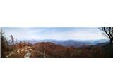
Lubnik is a 1025 m high mountain that rises steeply west of Škofja Loka. From the summit, where a mountain hut stands, there is a beautiful view ...
2 h 15 min |
 | Mesnice - Krim (by road)
Krim is a 1,107-metre-high mountain rising south of the Ljubljana Marsh. From the summit, where a mountain hut and several transmitters stand, th...
1 h 50 min |
 | Rakitna - Krim
Krim is a 1,107-metre-high mountain rising south of the Ljubljana Marsh. From the summit, where a mountain hut and several transmitters stand, th...
2 h |
 | Korensko sedlo - Ofen/Peč
Peč (also known as Tromeja; in Italian Monte Forno, in German Dreiländereck or Ofen) is a 1508 m high peak located at the tripoint between Sloven...
2 h |
 | Korensko sedlo - Ofen/Peč (on marked path)
Peč (also known as Tromeja; in Italian Monte Forno, in German Dreiländereck or Ofen) is a 1508 m high peak located at the tripoint between Sloven...
2 h |
 | Eko koča Nanos (Lovska koča Vojkovo) - Vojkova koča na Nanosu
Vojkova koča is located on the southern edge of the high karst Nanos plateau, near Pleša. This is the prominent peak with television transmitters...
1 h 50 min |
 | Furlanovo zavetišče pri Abramu - Vojkova koča na Nanosu
Vojkova koča is located on the southern edge of the high karst Nanos plateau, near Pleša. This is the prominent peak with television transmitters...
2 h |
 | Selo - Pasja ravan (via Ostrež)
Pasja ravan is the second-highest peak in the Polhograjsko hribovje. A few decades ago, at 1029 meters, it was the highest, but in the second hal...
2 h 15 min |
 | Polomova rajda - Kucelj (on Čaven) (by road)
Kucelj is located on the southern slopes of the Trnovski Forest, northwest of the Vipava Valley. From the bare summit, where a cross stands, ther...
1 h 45 min |
| Predmeja - Kucelj (on Čaven)
Kucelj is located on the southern slopes of the Trnovski Forest, northwest of the Vipava Valley. From the bare summit, where a cross stands, ther...
2 h |
 | Dom na Paškem Kozjaku - Basališče (Paški Kozjak)
Basališče is the highest peak of Paški Kozjak. A bench and a summit register have been placed on the summit. However, due to the forest, there is...
2 h |
 | Kampelc - Javornik (above Črni Vrh)
Javornik is a forested peak located southeast of Črni Vrh. In 1972, a wooden observation tower was built on it, rising above the treetops and off...
2 h 15 min |
 | Repna dolina - Javornik (above Črni Vrh)
Javornik is a forested peak located southeast of Črni Vrh. In 1972, a wooden observation tower was built on it, rising above the treetops and off...
1 h 45 min |
 | Sveti Trije kralji - Žigartov vrh
Žigartov vrh, at 1,346 meters, is the highest peak in the eastern part of Pohorje. An "observation" tower once stood on the summit, erected solel...
2 h 45 min |
| Koča na Šumiku - Žigartov vrh
Žigartov vrh, at 1,346 meters, is the highest peak in the eastern part of Pohorje. An "observation" tower once stood on the summit, erected solel...
1 h 55 min |
 | Pohorje cable car - Žigartov vrh (via Razglednik)
Žigartov vrh, at 1,346 meters, is the highest peak in the eastern part of Pohorje. An "observation" tower once stood on the summit, erected solel...
2 h 15 min |
| Pohorje cable car - Žigartov vrh (via Mariborska koča)
Žigartov vrh, at 1,346 meters, is the highest peak in the eastern part of Pohorje. An "observation" tower once stood on the summit, erected solel...
2 h 20 min |
 | Platak - Vidikovac
Vidikovac is a 1,408-meter-high peak in Gorski Kotar. From its partly unforested summit, there is a very beautiful view of the nearby Veliki Risn...
2 h 45 min |
 | Dom na Osankarici - Klopni vrh (eastern path)
From the northwest, Klopni vrh closes off the lower-lying extensive plateau on eastern Pohorje. The horizontal cross-sectional area at 1300 m is ...
2 h 45 min |
| Koča na Šumiku - Klopni vrh (eastern path)
From the northwest, Klopni vrh closes off the lower-lying extensive plateau on eastern Pohorje. The horizontal cross-sectional area at 1300 m is ...
2 h |
 | Koča na Šumiku - Klopni vrh (northern path)
From the northwest, Klopni vrh closes off the lower-lying extensive plateau on eastern Pohorje. The horizontal cross-sectional area at 1300 m is ...
2 h |
 | Dom planincev Farbanca - Tolsti vrh (Dobrovlje)
Tolsti vrh, together with Šentjoški vrh (1,077 m), is the highest peak of the Dobroveljska planota plateau. From the summit, which has a logbook ...
2 h |
| Dom na Čreti - Tolsti vrh (Dobrovlje)
Tolsti vrh, together with Šentjoški vrh (1,077 m), is the highest peak of the Dobroveljska planota plateau. From the summit, which has a logbook ...
1 h 45 min |
 | Zagrad - Medvižica (via Ostrič)
Medvižica is a rocky peak located on the Slovenian side of Čičarija. From the bare summit, there is a beautiful view of the surrounding hills, wi...
1 h 50 min |
| Zagrad - Medvižica (via Razsušica)
Medvižica is a rocky peak located on the Slovenian side of Čičarija. From the bare summit, there is a beautiful view of the surrounding hills, wi...
1 h 45 min |
 | Zagrad - Razsušica (via Ostrič)
Razsušica, at 1083 meters, is the highest peak of Slovenian Istria. Although the summit is partly vegetated, it offers a nice view towards the ne...
2 h 5 min |
 | Polomova rajda - Veliki Rob (via Kucelj)
Veliki Rob is a panoramic peak situated between Kuclj (1237 m) and Čaven (1185 m). From the summit, where there is a cross, there is a nice view ...
2 h 45 min |
 | Strma Reber - Cerk
Cerk, at 1,192 meters, is the highest peak of Borovška gora, a range situated between the Kolpa River valley and Goteniški Snežnik. From the summ...
1 h 45 min |
 | border crossing Remšnik - Kapunar / Kapunerkogel (via Sveti Urban)
Kapunar is a 1,051-meter-high peak above Radlje ob Dravi. Just below the summit stands an old customs post and border guardhouse, now used by ama...
2 h 20 min |
| border crossing Remšnik - Kapunar / Kapunerkogel (Austrian path)
Kapunar is a 1,051-meter-high peak above Radlje ob Dravi. Just below the summit stands an old customs post and border guardhouse, now used by ama...
2 h 5 min |
| Sv. Pankracij (Legat) / St. Pongratzen (Legat) - Kapunar / Kapunerkogel (via Sveti Urban)
Kapunar is a 1,051-meter-high peak above Radlje ob Dravi. Just below the summit stands an old customs post and border guardhouse, now used by ama...
2 h 10 min |
| Sv. Pankracij (Legat) / St. Pongratzen (Legat) - Kapunar / Kapunerkogel (Austrian path)
Kapunar is a 1,051-meter-high peak above Radlje ob Dravi. Just below the summit stands an old customs post and border guardhouse, now used by ama...
1 h 55 min |
| Sveti Jurij (Remšnik) - Kapunar / Kapunerkogel
Kapunar is a 1,051-meter-high peak above Radlje ob Dravi. Just below the summit stands an old customs post and border guardhouse, now used by ama...
2 h |
 | Koča pri Jelenovem studencu - Slovenski vrh
Slovenski vrh is a 1,041-meter-high mountain located in the ridge of Stojna, which lies between Kočevska Reka and Kočevje. The peak, a control po...
3 h |
 | Široko - Veliki vrh (above Lom) (via Grudnica - on trail Lom is my home)
Veliki vrh is located on the northeastern part of the Banjška planota plateau, which rises above Čepovani dol, the Soča river valley, and the Idr...
1 h 50 min |
 | Chortata - Egklouvi road - Stavrota (Lefkada)
Stavrota is the highest peak at 1,182 m on the Greek island of Lefkada (also known as Lefkas), which lies in the Ionian Sea. The Greek name of t...
1 h 50 min |
 | Koča na Šumiku - Veliki vrh (on Pohorje)
Veliki vrh is a 1344-meter-high peak located above the RTC Jakec - Trije kralji ski slope. The highest point of the peak is in the forest, but ju...
2 h |
 | Teichalm (Teichalmsee) - Rote Wand (lower path)
Rote Wand is a 1,505-meter-high mountain in the Graz Mountains in Styria, Austria. The name "Rote Wand" (red wall) comes from its southeast-facin...
2 h 15 min |
| Teichalm (Teichalmsee) - Rote Wand (upper path)
Rote Wand is a 1,505-meter-high mountain in the Graz Mountains in Styria, Austria. The name "Rote Wand" (red wall) comes from its southeast-facin...
2 h 15 min |
 | Planinski dom Orlove stine - Svilaja (past Umac)
Svilaja is a 1509-meter grassy peak above Peručko Lake, north of the town of Sinj. The summit features a cross and a concrete pillar. From the to...
2 h |
 | Malovan - Čardak (Tremzina)
Čardak is a peak on Tremzina, a smaller range east of the more famous Crnopac. Tremzina is located at the end of the Southern Velebit. There is a...
2 h |
 | Malovan - Oklinak
Oklinak is the highest peak of Tremzina, a smaller range east of the more famous Crnopac. Tremzina is located at the end of the Southern Velebit....
2 h 30 min |
 | Alpl (Zisleranger Weg) - Teufelstein
Teufelstein is a 1,498-meter-high mountain in the Fischbacher Alpen group. At the summit there is a cross with a summit logbook, and slightly bel...
2 h 20 min |
| Alpl (Zisleranger Weg) - Teufelstein (past Edelweißhütte)
Teufelstein is a 1,498-meter-high mountain in the Fischbacher Alpen group. At the summit there is a cross with a summit logbook, and slightly bel...
2 h 40 min |
 | Nechnitz - Gerlerkogel (via Gschaidberg)
Gerlerkogel is a 1324-meter-high peak situated in the Almenland nature park. From the grassy peak, a beautiful view opens up of the surrounding m...
2 h 15 min |
 | Schanzsattel - Stanglalpe
Stanglalpe is a peak in the Fischabacher Alpen mountain group, which lies in the hills east of the Mur. The peak itself is situated beside a road...
2 h 20 min |
 | Omar - Črni vrh (above Klenovica)
Črni vrh is a distinct peak situated above Klenovica. It is located near the more famous Kolovratske stijene. From the summit, which has a logboo...
1 h 45 min |