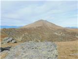
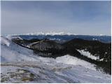
 | Tomčeva koča na Poljški planini - Begunjščica
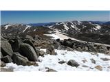
Begunjščica is a mountain range in the Karawanks east of Stol. Its highest peak is Veliki Vrh, which at over 2,000 m offers a fine view across ce...
2 h 50 min |
 | Rudno polje - Lipanski vrh
The panoramic Lipanski vrh is located above the Blejska koča on the Lipanca mountain pasture. From the summit, which drops steeply towards the Kr...
2 h 55 min |
 | Strmec - Debela peč (via Spodnja Brda)
Debela peč is a 2014 m high mountain that rises steeply above the Krma valley on one side and gently descends towards the expansive Pokljuka fore...
2 h 45 min |
 | Šport hotel - Debela peč
Debela peč is a 2014 m high mountain that rises steeply above the Krma valley on one side and gently descends towards the expansive Pokljuka fore...
3 h 30 min |
 | Rudno polje - Debela peč
Debela peč is a 2014 m high mountain that rises steeply above the Krma valley on one side and gently descends towards the expansive Pokljuka fore...
3 h 15 min |
 | Vrh Bače - Črna prst
On the northern slope of the summit ridge of Črna prst, black soil is visible the feature after which the mountain is named. Črna prst is renown...
3 h 10 min |
 | Bukovnik - Velika Raduha (via Durce)
Velika Raduha, at 2062 m, is the highest peak of the Raduha range, which rises steeply east of Robanov Kot. From the summit, with its registratio...
2 h 50 min |
 | Planina Blato - Mala Tičarica (via Štapce)
Mala Tičarica is a highly panoramic mountain above the Twin Triglav Lakes. From the summit there is a beautiful view toward the Koča pri Triglavs...
3 h 25 min |
 | End of road on Vogar - Mala Tičarica (via Štapce)
Mala Tičarica is a highly panoramic mountain above the Twin Triglav Lakes. From the summit there is a beautiful view toward the Koča pri Triglavs...
3 h 30 min |
 | Šport hotel - Brda (east path)
Brda is a panoramic peak situated between Pokljuka and Krma. The summit has a stamp attached to a metal pole and offers a beautiful view towards ...
3 h 15 min |
 | Rudno polje - Brda (east path)
Brda is a panoramic peak situated between Pokljuka and Krma. The summit has a stamp attached to a metal pole and offers a beautiful view towards ...
3 h 10 min |
 | Rudno polje - Brda (west path)
Brda is a panoramic peak situated between Pokljuka and Krma. The summit has a stamp attached to a metal pole and offers a beautiful view towards ...
2 h 55 min |
 | Valvasorjev dom - Prešernova koča na Stolu (Zabreška way)
The Prešernova koča na Stolu mountain hut is located just a few metres below the summit of the 2198 m high Mali Stol. From the hut or the nearby ...
3 h 5 min |
 | Valvasorjev dom - Prešernova koča na Stolu (Žirovniška way)
The Prešernova koča na Stolu mountain hut is located just a few metres below the summit of the 2198 m high Mali Stol. From the hut or the nearby ...
2 h 45 min |
 | Razpotje Vragovec - Prešernova koča na Stolu (via Zabreška planina)
The Prešernova koča na Stolu mountain hut is located just a few metres below the summit of the 2198 m high Mali Stol. From the hut or the nearby ...
2 h 45 min |
 | Ski hotel Vogel - Rodica
The mountain Rodica is located above Bohinj in the Lower Bohinj Mountains. From the summit there is a beautiful view over the Julian Alps and the...
3 h |
 | Kriška planina - Kalški greben (via planina Koren)
Kalški greben is a 2224 m high peak and the highest point of the ridge bearing the same name. From the summit, where there is a summit register a...
3 h 45 min |
| Dom na Gospincu - Kalški greben (via Dolga Njiva)
Kalški greben is a 2224 m high peak and the highest point of the ridge bearing the same name. From the summit, where there is a summit register a...
3 h 20 min |
 | Kriška planina - Mokrica (via Kompotela)
Mokrica is a panoramic peak east of Kompotela. The summit, partially covered with dwarf pines, has a summit logbook....
2 h 45 min |
| Planina Jezerca - Mokrica (via Kompotela)
Mokrica is a panoramic peak east of Kompotela. The summit, partially covered with dwarf pines, has a summit logbook....
3 h |
 | Rudno polje - Debeli vrh above Lipanca (via Kačji rob)
Debeli vrh is a 1962 m high mountain located in the ridge that rises steeply above the Krma valley. From the summit, where a stamp is attached to...
2 h 45 min |
 | Šport hotel - Debeli vrh above Lipanca
Debeli vrh is a 1962 m high mountain located in the ridge that rises steeply above the Krma valley. From the summit, where a stamp is attached to...
3 h 15 min |
| Rudno polje - Debeli vrh above Lipanca (via Blejska koča)
Debeli vrh is a 1962 m high mountain located in the ridge that rises steeply above the Krma valley. From the summit, where a stamp is attached to...
2 h 45 min |
 | Valvasorjev dom pod Stolom - Potoški Stol
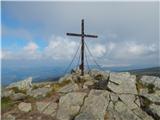
Potoški Stol is located between Stol and Vajnež on the border with Austria. A cross stands just a few metres below the grassy summit. The finest ...
3 h 5 min |
 | Planina Kuk - Vogel (direct way)
Many associate the name Vogel first with the Vogel ski resort near the eponymous peak. From the north, it is recognizable by its pyramidal shape,...
2 h 45 min |
| Planina Kuk - Vogel (via Globoko)
Many associate the name Vogel first with the Vogel ski resort near the eponymous peak. From the north, it is recognizable by its pyramidal shape,...
3 h 30 min |
 | Andrejev dom na Slemenu - Uršlja gora (Plešivec)
Uršlja gora, or Plešivec, is a panoramic mountain between Slovenj Gradec and Črna na Koroškem. At or just below the summit stands the Church of S...
2 h 45 min |
 | Koutschitz Alm/Kočiška planina - Poludnig/Poludnik
Poludnik/Poludnig is located on the eastern part of the Carnic Alps. Because there is no higher peak nearby, there is a very nice view from Polud...
3 h |
 | Waldheimhütte - Zirbitzkogel (via Wildsee)
Zirbitzkogel, at 2,396 m, is the highest peak of the Labotniške Alpe / Seetaler Alpen. From the summit, where a cross and a panorama board stand,...
3 h 32 min |
| Waldheimhütte - Zirbitzkogel (via Rothaidenhütte)
Zirbitzkogel, at 2,396 m, is the highest peak of the Labotniške Alpe / Seetaler Alpen. From the summit, where a cross and a panorama board stand,...
3 h 7 min |
| Waldheimhütte - Zirbitzkogel (via Lavantsee)
Zirbitzkogel, at 2,396 m, is the highest peak of the Labotniške Alpe / Seetaler Alpen. From the summit, where a cross and a panorama board stand,...
2 h 47 min |
 | Waldheimhütte - Fuchskogel (via Wildsee)
Fuchskogel is a peak south of Zirbitzkogel in the Seetaler Alpen mountain group. The summit is broad and mostly covered in grass. More precisely,...
2 h 45 min |
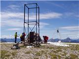
 | Waldheimhütte - Scharfes Eck (Direct way)
Scharfes Eck is a peak on which stands an Austrian meteorological radar station. From the summit, there is a beautiful view of the neighbouring p...
2 h 45 min |
| Tonnerhütte - Scharfes Eck
Scharfes Eck is a peak on which stands an Austrian meteorological radar station. From the summit, there is a beautiful view of the neighbouring p...
3 h |
 | Salzstiegelhaus - Großenberg (Packalpe) (via Ameringkogel)
Großenberg, also known as Größing, is the northernmost two-thousander in the Packalpe mountain group. From its expansive grassy summit, where a t...
3 h |
| Salzstiegelhaus - Großenberg (Packalpe)
Großenberg, also known as Größing, is the northernmost two-thousander in the Packalpe mountain group. From its expansive grassy summit, where a t...
2 h 55 min |
 | Nassfeld - Monte Cavallo / Rosskofel (via Sella di Aip / Rudnig sattel)
Konjski Špik / Monte Cavallo di Pontebba / Rosskofel is a 2,240-meter-high and highly panoramic mountain in the main ridge of the Carnic Alps in ...
4 h |
 | Pod Peco / Koprein-Petzen - Petzen (Kordeschkopf) (Peca (Kordeževa glava)) (slovenska pot)
Kordeževa glava, better known as Peca, is the highest peak of the Peca range. It is located on the border with Austria above the Mežiška dolina v...
3 h 50 min |
| Koprivna (Kumer) - Petzen (Kordeschkopf) (Peca (Kordeževa glava))
Kordeževa glava, better known as Peca, is the highest peak of the Peca range. It is located on the border with Austria above the Mežiška dolina v...
3 h 25 min |
 | Spodnje Sleme - Govca (Olševa)
Govca is the highest peak of the Olševa range, rising above Koprivna, Solčava, and Remšenik (Remšenik/Remschenig is a valley on the Austrian side...
3 h |
 | Pod Peco / Koprein-Petzen - Govca (Olševa) (via Kumer)
Govca is the highest peak of the Olševa range, rising above Koprivna, Solčava, and Remšenik (Remšenik/Remschenig is a valley on the Austrian side...
4 h 30 min |
| Mountain hut on farm Kumer - Govca (Olševa)
Govca is the highest peak of the Olševa range, rising above Koprivna, Solčava, and Remšenik (Remšenik/Remschenig is a valley on the Austrian side...
3 h 45 min |
 | Windische Hohe - Kobesnock
Kobesnock is a lesser-known peak west of the massive Dobrač range. From its summit, which features a cross, there are fine views of Dobrač, the l...
2 h 45 min |
 | Weinebene - Großer Speikkogel (Koralpe) (panoramic path)
Großer Speikkogel is, at 2,140 meters, the highest peak of Golica/Koralpe, a range east of Volšperk/Wolfsberg. From the summit, where a cross and...
3 h |
 | parking below Weinebene - Großer Speikkogel (Koralpe) (panoramic path)
Großer Speikkogel is, at 2,140 meters, the highest peak of Golica/Koralpe, a range east of Volšperk/Wolfsberg. From the summit, where a cross and...
3 h |
| parking below Weinebene - Großer Speikkogel (Koralpe) (via cross Schäferkreuz)
Großer Speikkogel is, at 2,140 meters, the highest peak of Golica/Koralpe, a range east of Volšperk/Wolfsberg. From the summit, where a cross and...
3 h 15 min |
| parking below Weinebene - Großer Speikkogel (Koralpe) (via Grünangerhütte)
Großer Speikkogel is, at 2,140 meters, the highest peak of Golica/Koralpe, a range east of Volšperk/Wolfsberg. From the summit, where a cross and...
3 h 10 min |
 | Weinebene - Großer Speikkogel (Koralpe) (above Pomswasserfall)
Großer Speikkogel is, at 2,140 meters, the highest peak of Golica/Koralpe, a range east of Volšperk/Wolfsberg. From the summit, where a cross and...
3 h 45 min |
| Oberfresen (Brendlwald) - Großer Speikkogel (Koralpe) (lower path)
Großer Speikkogel is, at 2,140 meters, the highest peak of Golica/Koralpe, a range east of Volšperk/Wolfsberg. From the summit, where a cross and...
4 h 15 min |
| Oberfresen (Brendlwald) - Großer Speikkogel (Koralpe) (upper path)
Großer Speikkogel is, at 2,140 meters, the highest peak of Golica/Koralpe, a range east of Volšperk/Wolfsberg. From the summit, where a cross and...
3 h 45 min |
| Glashütten - Großer Speikkogel (Koralpe)
Großer Speikkogel is, at 2,140 meters, the highest peak of Golica/Koralpe, a range east of Volšperk/Wolfsberg. From the summit, where a cross and...
3 h 55 min |
 | Ladinger Straße - Ladinger Spitz (Saualpe) (via Ladinger Hütte)
Velika Svinja, known in German as Ladinger Spitz, is at 2079 m the highest peak of the Svinja / Saualpe mountain range. From the summit, which ha...
3 h |
 | Ladinger Straße - Ladinger Spitz (Saualpe) (via Wolfsberger Hütte)
Velika Svinja, known in German as Ladinger Spitz, is at 2079 m the highest peak of the Svinja / Saualpe mountain range. From the summit, which ha...
2 h 50 min |
 | Klippitztörl - Ladinger Spitz (Saualpe) (via Geierkogel and Gertrusk)
Velika Svinja, known in German as Ladinger Spitz, is at 2079 m the highest peak of the Svinja / Saualpe mountain range. From the summit, which ha...
4 h 10 min |
| Klippitztörl - Ladinger Spitz (Saualpe)
Velika Svinja, known in German as Ladinger Spitz, is at 2079 m the highest peak of the Svinja / Saualpe mountain range. From the summit, which ha...
3 h 35 min |
 | Rudno polje - Okroglež
Okroglež is a peak covered with dwarf pines, located between Debela peč and Brda. From the summit, which has a stamp (no logbook), a nice view op...
2 h 55 min |
 | Koprivna (Kumer) - Wackendorfer Spitze
Veška kopa, also known as Veški vrh or by its German name Wackendorfer Spitze, is the northernmost two-thousander in the Peca range. From its ind...
2 h 55 min |
 | Jakobe - Feistritzer Spitze (easy path)
Bistriška špica is a 2113 m high peak located on the Austrian side of Peca. From the summit, which features a cross, there is a fine view of the ...
3 h 45 min |
| Koprivna (Kumer) - Feistritzer Spitze (Austrian path)
Bistriška špica is a 2113 m high peak located on the Austrian side of Peca. From the summit, which features a cross, there is a fine view of the ...
2 h 55 min |
 | Koprivna (Kumer) - Feistritzer Spitze (slovenska pot)
Bistriška špica is a 2113 m high peak located on the Austrian side of Peca. From the summit, which features a cross, there is a fine view of the ...
3 h 40 min |
 | Koprein-Petzen - Končnikov vrh (Peca)
Končnikov vrh (German: Knieps) is a 2109 m high peak situated in the central part of Peca. From the grassy summit, there is a beautiful view of t...
3 h 15 min |
 | Pod Peco/Koprein-Petzen - Končnikov vrh (Peca) (slovenska pot)
Končnikov vrh (German: Knieps) is a 2109 m high peak situated in the central part of Peca. From the grassy summit, there is a beautiful view of t...
3 h 15 min |
| Koprivna (Kumer) - Končnikov vrh (Peca) (slovenska pot)
Končnikov vrh (German: Knieps) is a 2109 m high peak situated in the central part of Peca. From the grassy summit, there is a beautiful view of t...
2 h 55 min |
| Jakobe - Končnikov vrh (Peca) (easy path)
Končnikov vrh (German: Knieps) is a 2109 m high peak situated in the central part of Peca. From the grassy summit, there is a beautiful view of t...
2 h 45 min |
 | Bohinjsko sedlo - Gladki vrh (Ratitovec)
Gladki vrh (Ratitovec), at 1,667 meters, is the most visited peak in the Ratitovec range. From its bare summit, which features a panorama board, ...
3 h 35 min |
 | Forestry cottage Rovtarica - Gladki vrh (Ratitovec)
Gladki vrh (Ratitovec), at 1,667 meters, is the most visited peak in the Ratitovec range. From its bare summit, which features a panorama board, ...
3 h 35 min |
 | Razglednik - Gladki vrh (Ratitovec)
Gladki vrh (Ratitovec), at 1,667 meters, is the most visited peak in the Ratitovec range. From its bare summit, which features a panorama board, ...
3 h 5 min |
 | Bohinjsko sedlo - Altemaver (Ratitovec)
Altemaver (Ratitovec), at 1,678 meters, is the highest peak of Ratitovec. From its grassy summit, there is a beautiful view of the Julian Alps, J...
3 h 15 min |
 | Forestry cottage Rovtarica - Altemaver (Ratitovec)
Altemaver (Ratitovec), at 1,678 meters, is the highest peak of Ratitovec. From its grassy summit, there is a beautiful view of the Julian Alps, J...
3 h 40 min |
| Razglednik - Altemaver (Ratitovec)
Altemaver (Ratitovec), at 1,678 meters, is the highest peak of Ratitovec. From its grassy summit, there is a beautiful view of the Julian Alps, J...
3 h 10 min |
| Soriška peč - Altemaver (Ratitovec)
Altemaver (Ratitovec), at 1,678 meters, is the highest peak of Ratitovec. From its grassy summit, there is a beautiful view of the Julian Alps, J...
3 h |
 | Plockenpass - Creta di Collinetta / Cellon
Creta di Collinetta / Cellon is a 2,238-meter-high mountain located west of the Plöcken Pass. From the summit, which features a cross, there is a...
3 h |
 | Planina Ravne - Mala Ojstrica (via Dolga trata)
Mala Ojstrica is an indistinct peak located between Ojstrica, Molička Planina mountain pasture, and Korošica. From the summit, which features a l...
3 h 45 min |
 | Heidi Alm - Mallnock (via Klomnock)
Mallnock is a 2226 m high peak located north of the settlement St. Oswald in the Krške Alpe. From the summit, where a cross stands, a beautiful v...
2 h 45 min |
 | Bad Kleinkirchheim - Wöllaner Nock
Wöllaner Nock is a 2145 m high peak located south of the ski area and the settlement Bad Kleinkirchheim. From the spacious summit, where a larger...
3 h 45 min |
| Bad Kleinkirchheim - Wöllaner Nock (by road)
Wöllaner Nock is a 2145 m high peak located south of the ski area and the settlement Bad Kleinkirchheim. From the spacious summit, where a larger...
4 h 15 min |
 | Bad Kleinkirchheim - Kaiseburg
Kaiseburg is a panoramic peak located directly above the Bad Kleinkirchheim ski area. From the summit, where a cross stands, a beautiful view ope...
3 h 25 min |
 | Bad Kleinkirchheim - Kaiseburg (by road)
Kaiseburg is a panoramic peak located directly above the Bad Kleinkirchheim ski area. From the summit, where a cross stands, a beautiful view ope...
3 h 55 min |
 | Turracher Höhe - Straßburger Spitz
Straßburger Spitz is a 2,404-meter-high peak located between the summits of Eisenhut (2,441 m) and Wintertalernock (2,394 m). From the top, where...
4 h 45 min |
 | Thredbo - Mount Kosciuszko (Merritts Track & Mt. Kosciuszko Track)
Mount Kosciuszko is the highest mountain on mainland Australia, the easiest of the elite "Seven Summits", and it is also on the Ultra list. The m...
4 h |
 | Klippitztörl - Gertrusk (Saualpe) (via Geierkogel)
Gertrusk is a panoramic two-thousander in the central part of the Saualpe. A cross stands on the summit, next to it a summit register box with a ...
3 h 35 min |
| Vitlenica - Veliki Vilinac (Vitlenica - Vilinac)
Veliki Vilinac is one of the peaks of the Čvrsnica mountain range, located west of Jablanica in Blidinje Nature Park. Čvrsnica is bounded by the ...
3 h |
 | parking below Weinebene - Krakaberg (Golica / Koralpe) (panoramic path)
Krakaberg is a 2,070-meter-high peak located south of Großer Speikkogel, the highest peak of Golica / Koralpe. From the summit, a nice view opens...
3 h 10 min |
 | parking below Weinebene - Steinschneider (above Pomswasserfall)
Steinschneider is a 2070-meter-high peak in the Golica / Koralpe mountain range, situated northwest of Großer Speikkogel, the highest peak of the...
3 h 20 min |
 | Oberfresen (Brendlwald) - Bürgerhalt (Koralpe)
Bürgerhalt is a lesser-known peak in the Golica / Koralpe mountain range, situated between the peaks Krennkogel and Großer Frauenkogel....
3 h 15 min |
 | Koprivna (Kumer) - Križnik (Peca) (slovenska pot)
Križnik is a 2,109-meter-high peak on Peca, located on the Austrian side of the mountain. From the summit, just a short way above the marked path...
3 h 15 min |
| Koprein-Petzen - Križnik (Peca)
Križnik is a 2,109-meter-high peak on Peca, located on the Austrian side of the mountain. From the summit, just a short way above the marked path...
3 h |