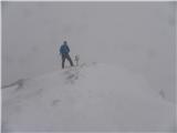
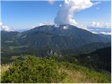
 | Planina Vetrh - Veliki Javornik (Ženiklovec)
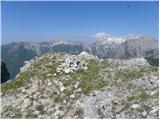
Veliki Javornik (also known as Ženiklovec) is a 1716 m high peak located between Storžič and Stegovnik. From the grassy summit with its registrat...
1 h 30 min |
 | Planina Dol - Rzenik (west path)
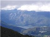
Rzenik is a grassy peak surrounded by dwarf pines that drops precipitously into the Kamniška Bela valley. From the summit, in clear weather, a wo...
1 h 40 min |
 | Planina Dol - Rzenik (east path)
Rzenik is a grassy peak surrounded by dwarf pines that drops precipitously into the Kamniška Bela valley. From the summit, in clear weather, a wo...
1 h 40 min |
 | Kozji hrbet - Možic
Možic is a 1,602 m high peak located west of Soriška Planina. At the very summit there is an old military bunker bearing the name of the peak and...
1 h |
 | Kališe - Kranjska reber
Kranjska reber, also known as Vrh Kašne planine (1435 m), is a mountain of volcanic origin. From the summit, which has a registration box with a ...
1 h 30 min |
| Volovljek - Kranjska reber (on unmarked path)
Kranjska reber, also known as Vrh Kašne planine (1435 m), is a mountain of volcanic origin. From the summit, which has a registration box with a ...
1 h 15 min |
 | Bohinjsko sedlo - Slatnik (northwestern peak) (direct way)
Slatnik is a panoramic mountain located west of the Soriška Planina ski resort. From its grassy summit there is a beautiful view of the Škofjeloš...
1 h |
| Bohinjsko sedlo - Slatnik (northwestern peak) (by Lajnar)
Slatnik is a panoramic mountain located west of the Soriška Planina ski resort. From its grassy summit there is a beautiful view of the Škofjeloš...
1 h 15 min |
 | Pod Krnico - Plešivec
Plešivec is an 1801 m high peak situated south of the eastern part of Košuta. From the summit, where a border marker stands, there is a beautiful...
1 h 20 min |
 | Pod Krnico - Mala Košuta
Mala Košuta (in German: Kleine Koschuta) is a 1740 m high peak located at the far eastern end of the Košuta ridge. From the summit, which drops s...
1 h 15 min |
 | Kosmačev preval - Črna gora
The summit is located between the Kot and Vrata valleys. A bivouac with two sleeping places stands on the summit. The view is beautiful towards K...
1 h 15 min |
 | Planina Vetrh - Bela peč (via Koča pr. Zdravc)
The mountain, known mainly among climbers, is located north of Storžič on the slopes of Konjščica. From the summit there is a beautiful view of t...
1 h 15 min |
 | Križovec - Ptičji vrh
Ptičji vrh is a 1550-meter-high mountain located in the main ridge of the Karavanke, between Struška and Golica. From the summit, through which t...
1 h |
 | Planina Dol - Koritni vrh (Velika planina)
Koritni vrh is a 1648 m high mountain on the northern part of Velika planina. From the summit, where a small cross stands, there is a beautiful v...
1 h |
 | Koča na Gozdu - Vršič vrh (on old road)
Vršič is a 1,737-metre-high mountain situated between the Poštarski dom hut and the Vršič pass. From the summit, where there is a registration bo...
1 h 30 min |
 | Dom na Smrekovcu - Krnes (via Smrekovec)
The summit is located in the heart of the Smrekovec mountain range and offers a beautiful view. Peca, Uršlja gora, and part of the highest peaks ...
1 h 35 min |
 | Za Malim vrhom - Krevl
Krevl is a 1515-meter-high peak situated south of the Kobla ski area, more precisely between the Kobla peak and Kravja Črna gora. From the summit...
1 h |
 | Jezero Sobote / Stausee Soboth - Huhnerkogel/Košenjak (on unmarked path)
Košenjak is located north of Dravograd and the Drava River on the border with neighbouring Austria. Access to Košenjak is possible on foot or by ...
1 h 40 min |
 | Avsa - Mrzli vrh (on Matajur)
Mrzli vrh is a 1358-meter-high peak located in the Matajur range. From the summit, where there is a panorama board and a summit register box with...
1 h 25 min |
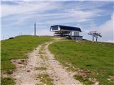 | Dom na Gospincu - Krvavec
Krvavec is a 1,853-meter-high peak located in the heart of the eponymous ski resort. From the summit, which is crisscrossed with cable cars, ther...
1 h |
 | Dom Pristava in Javorniški Rovt - Španov vrh
Španov vrh is a 1334-meter-high mountain in the Karavanke that rises between Javorniški Rovt and Planina pod Golico. From the scenic summit, acce...
1 h 30 min |
| Planina pod Golico - Španov vrh
Španov vrh is a 1334-meter-high mountain in the Karavanke that rises between Javorniški Rovt and Planina pod Golico. From the scenic summit, acce...
1 h 15 min |
 | Planina Lom - Kobilja glava
Kobilja glava is a 1,475-meter-high peak located east of Tolmin. From the summit, where a cross stands, there is a beautiful view of Krn, the ran...
1 h 15 min |
 | Koča na planini Stador - Jalovnik
Jalovnik is a grassy peak located southeast of the slightly higher Kobilja glava. From the summit, which has a summit logbook, there is a nice vi...
1 h 30 min |
| Planina Lom - Jalovnik
Jalovnik is a grassy peak located southeast of the slightly higher Kobilja glava. From the summit, which has a summit logbook, there is a nice vi...
1 h 30 min |
 | Korensko sedlo - Jerebikovec/Rawikautz
Jerebikovec is a 1621 m high mountain rising east of Korensko sedlo. From its partly grassy summit, surrounded by forest, there is no view....
1 h 20 min |
 | Koča na Gozdu - Visoki Mavrinc
Visoki Mavrinc (Špica v Sedelcih) is a 1562 m high mountain between Suha, Mala, and Velika Pišnica. From the summit, where a wooden cross and ple...
1 h 15 min |
 | Križovec - Mala Golica
Mala Golica is a less distinct peak located east of Krvavka. From its grassy summit, there is a nice view of the Dravska dolina, Struško, parts o...
1 h 20 min |
 | Poden / Bodental - Požgani rob
Požgani rob is a 1,513-meter-high mountain north of Rjavca. The summit is surrounded by forest, so there is no good view from it, but a nice pano...
1 h 10 min |
 | Planina Loka - Kup (on Raduha)
Kup is a 1,808-meter-high peak situated on the far northeastern part of Raduha. From the summit, where a cross stands, a beautiful view opens up ...
1 h 20 min |
 | Rotek - Erbelc
Erbelc is a 1,308-meter-high peak that rises steeply above Zgornja Sorica. From the summit, which has a summit logbook, there is a fine view of t...
1 h 15 min |
| Spodnje Danje - Erbelc
Erbelc is a 1,308-meter-high peak that rises steeply above Zgornja Sorica. From the summit, which has a summit logbook, there is a fine view of t...
1 h 15 min |
 | Rotek - Tonderškofel
Tonderškofel is a 1,326-meter-high peak located between Soriška peč and Erbelc. From the partly overgrown summit, which has no marked trail leadi...
1 h 15 min |
| Spodnje Danje - Tonderškofel
Tonderškofel is a 1,326-meter-high peak located between Soriška peč and Erbelc. From the partly overgrown summit, which has no marked trail leadi...
1 h 15 min |
 | Planina pod Golico - Na pečeh at Črni Vrh
Na pečeh is a lesser-known panoramic peak at 1,318 meters above sea level, rising east above the village of Planina pod Golico. Before the Španov...
1 h 5 min |
 | Tolminske Ravne - Javor (above Tolminske Ravne)
Javor is a 1,363-meter-high peak situated between Tolminske Ravne and Grušnica. From the summit, which features a small cross, nice views open up...
1 h 20 min |
 | Pod Debelo glavo - Gradovec
Gradovec is a 1,692-meter-high peak located north of the ridge of Spodnje Bohinjske gore, specifically above the mountain pasture Poljana. From t...
1 h 35 min |
 | Korensko sedlo - Petelinjek (above Korensko sedlo) (on Austrian side)
Petelinjek is a smaller ridge located west to southwest of Korensko sedlo. The ridge is mostly on the Slovenian side, with only the highest peak ...
1 h 30 min |
 | Polja - Kališje
Kališje is a lesser-known peak in the western part of the Karawanks. From the summit, where transmitters are located, there are some views toward...
1 h 40 min |
 | Topla (Končnik) - Šoparjev vrh
Šoparjev vrh is a 1,524-meter-high mountain located between Olševa and Peca, more precisely on the ridge separating the Koprivna Valley from the ...
1 h 15 min |
| Koprivna (Kumer) - Šoparjev vrh
Šoparjev vrh is a 1,524-meter-high mountain located between Olševa and Peca, more precisely on the ridge separating the Koprivna Valley from the ...
1 h 10 min |
| Pod Peco / Koprein-Petzen - Šoparjev vrh
Šoparjev vrh is a 1,524-meter-high mountain located between Olševa and Peca, more precisely on the ridge separating the Koprivna Valley from the ...
1 h 35 min |
 | Poden / Bodental - Veronjak / Hausberg
Veronjak / Hausberg is a 1,348-meter-high peak located above the Poden / Bodental valley on the Austrian side of the Karawanks. From the summit, ...
1 h 20 min |
| Slovenji Plajberk / Windisch Bleiberg - Veronjak / Hausberg (via Veronjak / Hausberg)
Veronjak / Hausberg is a 1,348-meter-high peak located above the Poden / Bodental valley on the Austrian side of the Karawanks. From the summit, ...
1 h 25 min |
 | Medvodje - Penatca
Penatca is a 1,299-meter-high peak located above the right bank of the Tržiška Bistrica. The summit itself is in the forest, but a few steps to t...
1 h 40 min |
 | Erjavčev rovt - Bela peč (above Dovje)
Bela peč is a lesser-known peak located above the marked trail from Dovje to Dovška Baba. From the summit, there is a beautiful view to the south...
1 h 15 min |
 | 2nd turn of Vršič road - Škrbinjek
Škrbinjek is a 1,341-meter-high peak in the Julian Alps and Triglav National Park. The summit is located 2 km south-southwest of Kranjska Gora or...
1 h |
 | Feistritzsattel - Schöberlriegel
Schöberlriegel is a 1,704-meter-high peak situated north of Hochwechsel. From the summit, where a large cairn stands, a beautiful view opens up o...
1 h 40 min |
 | Straßegg - Zechnerschlag (Rohregg)
Zechnerschlag, or Rohregg, is a 1434-meter-high mountain situated in the Almenland nature park. From the summit, where a cross stands, a beautifu...
1 h 30 min |
 | Brneško sedlo - Mala Kopa
Mala Kopa is a 1,524-meter-high peak in the western part of the Pohorje. From the summit, where part of the Kope ski resort is also located, a be...
1 h 35 min |
| Koča Planinc - Mala Kopa
Mala Kopa is a 1,524-meter-high peak in the western part of the Pohorje. From the summit, where part of the Kope ski resort is also located, a be...
1 h 35 min |