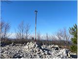
 | Lokvica - Veliki vrh (Črni hribi)
Veliki vrh is a 463-meter-high hill located in the Črni hribi ridge. From the summit, which has a summit logbox, there is no view due to the fore...
1 h 30 min |
 | Topole - Koseški hrib
Koseški hrib is located between Kuharjev boršt and Koseze, the settlement after which the peak is also named. From the summit, which has a table,...
55 min |
 | Dragomer - Strmca (via Debeli hrib)
Strmca is a lesser-known forested hill located between the settlements of Brezje pri Dobrovi and Log pri Brezovici. Due to the forest cover, ther...
1 h 15 min |
 | Brezje pri Dobrovi - Vrhovčev grič (via Strmca)
Vrhovčev grič is an indistinct, forested peak located just a few meters off the marked trail between Debeli hrib and Strmca....
50 min |
| Dragomer (bajer) - Vrhovčev grič (via Ferjanka and Strmca)
Vrhovčev grič is an indistinct, forested peak located just a few meters off the marked trail between Debeli hrib and Strmca....
1 h 10 min |
 | Komare doline - Kuk
Kuk (also known as Ščukovec on some maps) is a 498-meter-high hill north of the village Movraž. From the summit, which features a small cross, th...
1 h 15 min |
 | Zazid - Kuk
Kuk (also known as Ščukovec on some maps) is a 498-meter-high hill north of the village Movraž. From the summit, which features a small cross, th...
1 h |
 | Komare doline - Veliki Gradež
Veliki Gradež is a 507-meter-high rise between Zazid and Movraž. From the summit, amid expansive pastures, there is a fine view of the Primorska ...
1 h 30 min |
 | Loka pri Žusmu (Žamerk) - Castle Žusem
Castle Žusem (German Sussenheim), of which only ruins remain today, is located east to northeast of Žusem, a peak with a lookout tower....
50 min |
 | Šentilj v Slovenskih goricah - Plački vrh
Plački vrh is a peak in Slovenske Gorice. It lies in the municipality of Kungota, right on the border with Austria.A 28-meter-high lookout tower ...
1 h |
 | Repnje - Smledniški hrib (Stari grad)
Stari grad (also known as Smlednik Castle) is located on a small hill southwest of Valburga. In recent years, the castle has been renovated and n...
1 h 15 min |
 | Stari trg (Pilštanj) - Vina gora (zahodna pot)
Vina Gora is a scenic hill rising east of the medieval market town of Pilštanj. Its summit has been converted into an attractive open-air museum ...
55 min |
| Lesično - Vina gora (zahodna pot)
Vina Gora is a scenic hill rising east of the medieval market town of Pilštanj. Its summit has been converted into an attractive open-air museum ...
55 min |
| Lesično - Vina gora (along the water educational trail and along the western path)
Vina Gora is a scenic hill rising east of the medieval market town of Pilštanj. Its summit has been converted into an attractive open-air museum ...
55 min |
 | Rdeči Kal - Ostri vrh (above Globodol) (via Velika raven)
Ostri vrh is a 523-meter-high peak located between Vrbovec, Rdeči Kal, Gorenji, Srednji, and Dolenji Globodol, Dolnji and Gornji Ajdovec, and Pod...
1 h 15 min |
| Dom Frata - Ostri vrh (above Globodol)
Ostri vrh is a 523-meter-high peak located between Vrbovec, Rdeči Kal, Gorenji, Srednji, and Dolenji Globodol, Dolnji and Gornji Ajdovec, and Pod...
1 h 20 min |
| Rdeči Kal - Ostri vrh (above Globodol) (via Dom LD Dobrnič)
Ostri vrh is a 523-meter-high peak located between Vrbovec, Rdeči Kal, Gorenji, Srednji, and Dolenji Globodol, Dolnji and Gornji Ajdovec, and Pod...
1 h |
 | Liboje - Kamčič (via organic farm Kralj - southern approach)
Kamčič is a wooded peak in the Posavje Hills, located north of Šmohor between Kotečnik to the left and Veliki Slomnik to the right. It is recogni...
1 h 10 min |
 | Brezje pri Dobrovi - Vrh (Debeli hrib) (via Strmca)
Vrh is a 540-meter-high hill on the Debeli hrib ridge, which lies between the Ljubljana Marshes and the Horjulščica river valley. The view from t...
1 h 15 min |
 | Dragomer - Vrh (Debeli hrib) (on Pentlja)
Vrh is a 540-meter-high hill on the Debeli hrib ridge, which lies between the Ljubljana Marshes and the Horjulščica river valley. The view from t...
1 h |
 | Treskavac - Veli Vrh
Veli Vrh is not the highest peak on the island of Krk, but it offers the best view of the entire island, the Bay of Rijeka / Riješki zaliv, Učka,...
50 min |
 | Okrog (Lazar) - Zaplaz
Zaplaz is a 543-meter-high hill located above Čatež, a settlement best known as the endpoint of the Levstik Trail (From Litija to Čatež). The sum...
1 h 10 min |
| Bridge over Dušica - Zaplaz
Zaplaz is a 543-meter-high hill located above Čatež, a settlement best known as the endpoint of the Levstik Trail (From Litija to Čatež). The sum...
1 h |
 | Gaber pri Semiču - Smuk (via Semenič)
Smuk is a 545-meter-high peak above Semič. The summit features the Church of St. Lawrence, a hunting cabin, and nearby ruins of Smuk (or Turn) Ca...
1 h 10 min |
 | Wildon - Buchkogel (Wildoner Berg)
Buchkogel or Wildoner Berg is a 550-meter-high hill in southern Styria. Buchkogel together with the peaks Wildoner Schlossberg (450 m) and Bockbe...
1 h 30 min |
 | Buzet Railway Station - Pilj (nad Buzetom)
Pilj is a grassy peak above Buzet. It is located on the edge of the cliff. From the summit, which has an inscription on the rock, a beautiful vie...
1 h |
 | Borovic (road on Hum) - Sveti Duh (Hum) (past Titova špilja)
Sveti Duh is a chapel located northeast of Hum, the highest peak on Vis island, though it is under military control and inaccessible. From the ch...
50 min |
 | Založe (Hotunjščica) - Sevčnik (Andraška pot (pri Vodostečni))
Sevčnik is a hill located northeast of Polzela along the PolzelaVelenje road. The nearest larger settlement is Andraž nad Polzelo. The summit off...
1 h 30 min |
 | Bad Gleichenberg (Eichgraben Weg) - Bschaidkogel (via Steinriegel)
Bschaidkogel is a 563-meter-high mountain located northeast of the town of Bad Gleichenberg....
1 h 30 min |
 | Treskavac - Obzova
Obzova is the highest point on the island of Krk. Like the entire surrounding area, the summit is completely rocky. Interesting are the pools nea...
1 h 30 min |
 | Šahovec - Trebni vrh (Baragova pot)
Trebni vrh is a 581-meter-high hill located south or southwest of Trebnje. On the forested summit stands a bench, and nearby is a logbook box wit...
1 h 5 min |
 | Velenje (Stari trg) - Veliko Gradišče
Gradišče is a hill above Pesje near Velenje.It has two peaks: Veliko Gradišče and Malo Gradišče.Veliko Gradišče lies west of the St. James church...
1 h |
 | Zreče (Terme Zreče) - Sveti Martin (Zlakova) (on PP1)
The Church of St. Martin is situated on a panoramic hill on the edge of Zlakova village. From the church, a nice view opens up towards part of Po...
55 min |
 | Ljubljana (Podutik) - Toško Čelo
Toško Čelo is a 590-metre hill above the village of the same name. From the summit, or slightly below it, a beautiful view opens over part of Lju...
1 h |
 | Radovljica - Lipnica Castle (Pusti grad above Lipnica) (on natural learning trail)
Lipniški Castle, or Pusti grad above Lipnica (German: Waldenberg), is located on a panoramic hill above the Sava and Lipnica watercourses, more p...
1 h 20 min |
 | Bad Gleichenberg (Eichgraben Weg) - Gleichenberger Kogel (via Mühlsteinbruch)
Gleichenberger Kogel is a 598-meter-high mountain of volcanic origin located above Bad Gleichenberg in Styria....
1 h 10 min |
| Bad Gleichenberg (Eichgraben Weg) - Gleichenberger Kogel
Gleichenberger Kogel is a 598-meter-high mountain of volcanic origin located above Bad Gleichenberg in Styria....
1 h 5 min |
 | Gleichenberg Dorf - Gleichenberger Kogel
Gleichenberger Kogel is a 598-meter-high mountain of volcanic origin located above Bad Gleichenberg in Styria....
50 min |
 | Preval Prosca - Visoki hrib
Visoki hrib is a 602-meter-high hill located south of Polhov Gradec. From the summit, which is partly overgrown with forest, a beautiful view ope...
50 min |
 | Polhov Gradec - Visoki hrib
Visoki hrib is a 602-meter-high hill located south of Polhov Gradec. From the summit, which is partly overgrown with forest, a beautiful view ope...
1 h 15 min |
 | Povir - Stari tabor
Stari Tabor is a panoramic peak located west of Divača, north of Lokev, and south of the village of Povir. From the summit, which has a stamp and...
1 h 10 min |
 | Povir - Stari tabor (harder path)
Stari Tabor is a panoramic peak located west of Divača, north of Lokev, and south of the village of Povir. From the summit, which has a stamp and...
1 h 15 min |
 | Ressnig - Aussicht Petelinz
The Petelinz viewpoint (Aussicht Petelinz) is located northeast of Borovelj/Ferlach, north of or directly above the Drava/Drau River. From the vi...
1 h |
 | Čatež - Bajturn (Zaplaški hrib) (on north slope)
Bajturn, or Zaplaški hrib, at 609 meters, is the highest peak in the Trebnje municipality. The summit features a pleasant bench with a table, a b...
50 min |
 | Zreče (Terme Zreče) - Golika
Golika is a 609-meter-high peak on Brinjeva gora, on which stands the church of St. Neža....
50 min |
 | Donji Borki - Petrov vrh above Daruvar
Petrov vrh is one of the peaks on Papuk Mountain. It is located above the town of Daruvar and is a popular destination for local residents. There...
1 h |
 | Zgornja Slivnica - Pugled
Pugled is a 615-meter-high peak situated between Podlipoglav and Veliki Lipoglav. From the summit, where a large NOB monument stands, the view is...
1 h 30 min |
 | Lovnik - Rančka
Rančka is a 615-meter-high peak located west to southwest of Boč. Just below the summit is a stamp box with a bench nearby; the highest point its...
1 h |
 | Oplotnica - Brinjeva gora (above Zreče) (above quarry)
Brinjeva gora is a prominent hill situated between Zreče and Oplotnica. It is known for several churches located along its entire ridge. Several ...
1 h 30 min |
 | Oplotnica - Brinjeva gora (above Zreče) (on forest path)
Brinjeva gora is a prominent hill situated between Zreče and Oplotnica. It is known for several churches located along its entire ridge. Several ...
1 h 30 min |
 | Zreče (Terme Zreče) - Brinjeva gora (above Zreče) (via farm Pudgrošek)
Brinjeva gora is a prominent hill situated between Zreče and Oplotnica. It is known for several churches located along its entire ridge. Several ...
50 min |
 | Zreče (Terme Zreče) - Brinjeva gora (above Zreče) (via Golika)
Brinjeva gora is a prominent hill situated between Zreče and Oplotnica. It is known for several churches located along its entire ridge. Several ...
1 h |
 | Puštal (Na Dobravi) - Sveti Andrej (above Zminec)
The Church of St. Andrew is located on a panoramic hill in the Sveti Andrej settlement. From the church, there is a fine view of the Škofjeloško ...
1 h 15 min |
 | Preval Prosca - Ključ
Ključ is a forest-covered peak located north of the village Brezje pri Dobrovi and south of Dolenja vas. The summit, which has a stamp box with l...
1 h |
 | Dolenja vas (Kosmulj) - Ključ
Ključ is a forest-covered peak located north of the village Brezje pri Dobrovi and south of Dolenja vas. The summit, which has a stamp box with l...
1 h 10 min |
 | Sveti Urh - Ključ
Ključ is a forest-covered peak located north of the village Brezje pri Dobrovi and south of Dolenja vas. The summit, which has a stamp box with l...
1 h |
 | Gorjane (Železno) - Rigelj
Rigelj is a 626-meter-high indistinct peak in the Orlice range, on which a few antennas stand....
1 h 20 min |
 | Višnja Gora - Sveti Duh (Polževo)
The Church of the Holy Spirit is located at 630 meters above sea level on a hill above Hotel Polževo. The stamp is a few dozen meters away, along...
1 h 30 min |
 | Rašica - Rašica (Vrh Staneta Kosca) (by road)
Vrh Staneta Kosca, better known as Rašica, is located north of Ljubljana, more precisely above the villages of Rašica and Dobeno. From the summit...
55 min |
| Rašica - Rašica (Vrh Staneta Kosca) (footpath)
Vrh Staneta Kosca, better known as Rašica, is located north of Ljubljana, more precisely above the villages of Rašica and Dobeno. From the summit...
55 min |
 | Selo pri Vodicah - Rašica (Vrh Staneta Kosca) (by road)
Vrh Staneta Kosca, better known as Rašica, is located north of Ljubljana, more precisely above the villages of Rašica and Dobeno. From the summit...
1 h 20 min |
 | Spodnje Dobeno - Rašica (Vrh Staneta Kosca)
Vrh Staneta Kosca, better known as Rašica, is located north of Ljubljana, more precisely above the villages of Rašica and Dobeno. From the summit...
50 min |
 | Gora - Trstelj
Trstelj is the highest peak in the ridge of Črni hribi. From the spacious summit, which has TV transmitters, the view is divided. From the north ...
50 min |
 | Mekinje nad Stično - Sveti Lambert
Sveti Lambert is located on an inconspicuous rise near the village of Pristava nad Stično. From the summit, once the site of a castle where Duche...
1 h 5 min |
 | Zazid - Jampršnik
Jampršnik is a little-known and even less visited peak located in the mountain chain southwest of Črni Kal. Despite its modest height, there is a...
1 h |
 | border crossing Lipica - Kokoš (steep way)
The Koča na Kokoši mountain hut is located on Jirmanec peak, just 5 minutes from the forested Kokoš. From the summit, situated south of Lokavsko ...
50 min |
| border crossing Lipica - Kokoš (by road)
The Koča na Kokoši mountain hut is located on Jirmanec peak, just 5 minutes from the forested Kokoš. From the summit, situated south of Lokavsko ...
1 h |
 | Lipica (Škibini) - Kokoš
The Koča na Kokoši mountain hut is located on Jirmanec peak, just 5 minutes from the forested Kokoš. From the summit, situated south of Lokavsko ...
50 min |
| Lokev - Kokoš
The Koča na Kokoši mountain hut is located on Jirmanec peak, just 5 minutes from the forested Kokoš. From the summit, situated south of Lokavsko ...
1 h 30 min |
 | Krvavi Potok - Kokoš
The Koča na Kokoši mountain hut is located on Jirmanec peak, just 5 minutes from the forested Kokoš. From the summit, situated south of Lokavsko ...
1 h 30 min |
| Prelože pri Lokvi - Kokoš
The Koča na Kokoši mountain hut is located on Jirmanec peak, just 5 minutes from the forested Kokoš. From the summit, situated south of Lokavsko ...
1 h 30 min |
 | Legastja - Sveti Florijan (Tehovec)
The Church of St. Florijan is a subsidiary church located in the village of Tehovec above Medvode. From the church, first mentioned in 1548, a ni...
50 min |