 | Ljubelj - Begunjščica (via Zelenica)
Begunjščica is a mountain range in the Karawanks east of Stol. Its highest peak is Veliki Vrh, which at over 2,000 m offers a fine view across ce...
3 h 50 min |
| Tinčkova koča - Begunjščica
Begunjščica is a mountain range in the Karawanks east of Stol. Its highest peak is Veliki Vrh, which at over 2,000 m offers a fine view across ce...
3 h 15 min |
 | Tinčkova koča - Begunjščica (via Poljška planina)
Begunjščica is a mountain range in the Karawanks east of Stol. Its highest peak is Veliki Vrh, which at over 2,000 m offers a fine view across ce...
3 h 50 min |
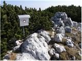
 | Rudno polje - Viševnik (via Kačji rob)
Viševnik is a 2050 m high mountain rising northwest of Rudno polje on Pokljuka. From the summit, where there is a stamp, a beautiful view opens o...
2 h 30 min |
| End of road on Pokljuka - Viševnik (via Srenjski preval)
Viševnik is a 2050 m high mountain rising northwest of Rudno polje on Pokljuka. From the summit, where there is a stamp, a beautiful view opens o...
2 h 15 min |
 | Planina Zajavornik - Viševnik
Viševnik is a 2050 m high mountain rising northwest of Rudno polje on Pokljuka. From the summit, where there is a stamp, a beautiful view opens o...
3 h 30 min |
| Medvedova konta - Viševnik
Viševnik is a 2050 m high mountain rising northwest of Rudno polje on Pokljuka. From the summit, where there is a stamp, a beautiful view opens o...
3 h 15 min |
| Pri Rupah - Viševnik
Viševnik is a 2050 m high mountain rising northwest of Rudno polje on Pokljuka. From the summit, where there is a stamp, a beautiful view opens o...
3 h 15 min |
| Rudno polje - Viševnik (via Jezerce and Srenjski preval)
Viševnik is a 2050 m high mountain rising northwest of Rudno polje on Pokljuka. From the summit, where there is a stamp, a beautiful view opens o...
2 h 40 min |
 | Uskovnica (Lom) - Viševnik (via Srenjski preval)
Viševnik is a 2050 m high mountain rising northwest of Rudno polje on Pokljuka. From the summit, where there is a stamp, a beautiful view opens o...
3 h 10 min |
| Uskovnica (Razpotje) - Viševnik (via Srenjski preval)
Viševnik is a 2050 m high mountain rising northwest of Rudno polje on Pokljuka. From the summit, where there is a stamp, a beautiful view opens o...
2 h 55 min |
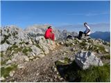
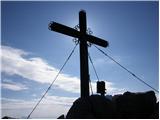
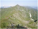
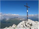
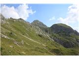
 | Ljubelj - Vertatscha/Vrtača
Vrtača is a 2181 m high peak located east of Stol. From the summit, where a large peg stands, a beautiful view opens over parts of the Julian Alp...
3 h 30 min |
| Tinčkova koča - Vertatscha/Vrtača (via Smuška planina in saddle Šija)
Vrtača is a 2181 m high peak located east of Stol. From the summit, where a large peg stands, a beautiful view opens over parts of the Julian Alp...
3 h 30 min |
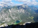
 | Rudno polje - Lipanski vrh (via Mrežce)
The panoramic Lipanski vrh is located above the Blejska koča on the Lipanca mountain pasture. From the summit, which drops steeply towards the Kr...
2 h 50 min |
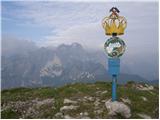
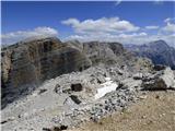
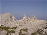 | Vršič - Mala Mojstrovka (southern way)
Mala Mojstrovka is one of the most visited peaks in the Julian Alps due to the relatively high elevation of its starting point. From the summit, ...
2 h 15 min |
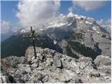
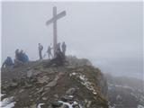
 | Trate / Johannsenruhe - Prešernova koča na Stolu (via Celovška koča)
The Prešernova koča na Stolu mountain hut is located just a few metres below the summit of the 2198 m high Mali Stol. From the hut or the nearby ...
3 h 40 min |
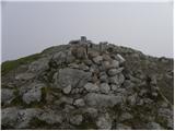
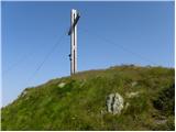
| Planina Jezerca - Mokrica (via Košutna)
Mokrica is a panoramic peak east of Kompotela. The summit, partially covered with dwarf pines, has a summit logbook....
3 h |
 | Ravenska Kočna - Ledinski vrh (hunter's way)
The mountain is located above Jezersko and lies on the border with Austria. From the summit there is a beautiful view north towards the neighbour...
3 h 30 min |
| Koča pod slapom Rinka - Ledinski vrh
The mountain is located above Jezersko and lies on the border with Austria. From the summit there is a beautiful view north towards the neighbour...
3 h 30 min |
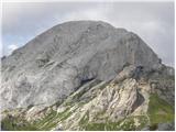
 | Globoka dolina - Kofce gora
Kofce gora is a 1967 m high peak located in the eastern part of the longest Slovenian ridge. From the summit, which drops precipitously towards A...
2 h 15 min |
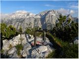
 | Mrzli studenec - Veliko Kladivo
Veliko Kladivo is a 2094 m high peak in the longest Slovenian ridge, Košuta. From the summit, which has a register box and stamp, there is a very...
2 h 15 min |
| Globoka dolina - Veliko Kladivo
Veliko Kladivo is a 2094 m high peak in the longest Slovenian ridge, Košuta. From the summit, which has a register box and stamp, there is a very...
3 h |
 | Planina Jezerca - Košutna (via planina Košutna)
The summit is located between Kompotela and the mountain pasture Košutna. From the top, there is a beautiful view toward Krvavec and Kalški grebe...
2 h 20 min |
 | Tinčkova koča - Bielschitza/Svačica (via Smokuška planina)
Svačica is a less prominent peak in the main ridge of the Karawanks. It lies between Vrtača and Stol, slightly offset to the north. The summit, m...
3 h 30 min |
 | Johannsenruhe - Bielschitza/Svačica
Svačica is a less prominent peak in the main ridge of the Karawanks. It lies between Vrtača and Stol, slightly offset to the north. The summit, m...
2 h 30 min |
| Bodenbauer - Bielschitza/Svačica (via Karweg)
Svačica is a less prominent peak in the main ridge of the Karawanks. It lies between Vrtača and Stol, slightly offset to the north. The summit, m...
3 h |
 | Planina Storeča raven - Vogel (po severozahodnih pobočjih Visokega Orlovega roba)
Many associate the name Vogel first with the Vogel ski resort near the eponymous peak. From the north, it is recognizable by its pyramidal shape,...
3 h 45 min |
 | Planina Storeča raven - Vogel (po zahodnih pobočjih smučišča Vogel)
Many associate the name Vogel first with the Vogel ski resort near the eponymous peak. From the north, it is recognizable by its pyramidal shape,...
3 h 45 min |
 | Planina Kuk - Vrh nad Škrbino (direct way)
Vrh nad Škrbino is the easternmost two-thousander in the ridge of the Lower Bohinj Mountains. From the summit, there are excellent views of the n...
3 h 15 min |
 | Cave del Predil - Kraljevska špica/Monte Re
Kraljevska špica, or Monte Re in Italian, is a 1912 m high mountain located northwest of Raibl/Cave del Predil. From its mining summit, where a c...
2 h 30 min |
 | Lienzer Dolomitenhütte - Laserzwand
Laserzwand is a 2614-meter-high mountain situated in the heart of the Lienz Dolomites. From its spacious and precipitous summit, a beautiful view...
3 h |
 | Rifugio Tolazzi - Rauchkofel
North of Monte Coglians, the highest peak of the Carnic Alps, lies the 2,460-meter-high Rauchkofel. From the summit, which features a cross and a...
3 h 15 min |
 | Raabtal - Steinkarspitz/Monte Antola
Steinkarspitz (Monte Antola in Italian) is a 2,524-meter-high mountain on the border ridge between Austria and Italy. From its grassy summit, the...
2 h 45 min |
 | Raabtal - Monte Vancomun / Hochspitz
Monte Vancomun / Hochspitz is a 2,580-meter-high mountain located south of the upper Gail Valley. From the summit, which features a cross, there ...
3 h 15 min |
 | Rifugio Sorgenti del Piave - Monte Avanza
Monte Avanza is a 2,489 m high peak located east of the better-known Monte Peralba. From the summit, where a small cross stands, nice views open ...
3 h |
 | Cristo di Forca - Amariana
Amariana is a beautiful pyramidal mountain rising above Tolmezzo. Due to its exposed position, it offers wonderful views of the surrounding range...
2 h 30 min |
 | San Martino - Cima della Rosetta
Cima della Rosetta is a 2,743-meter-high peak rising above the settlement of San Martino. From the summit, where a cross stands, there is a nice ...
3 h 40 min |
 | Fiames - Col Rosa
Col Rosa is a 2,166-meter-high mountain situated north of Cortina d'Ampezzo. From the summit, where a cross stands, there is a very nice view of ...
2 h 45 min |
 | Landro - Monte Piano
Monte Piano (Toblacher Kreuz) is a 2,305-meter-high mountain located on the northwestern edge of the Monte Piana plateau. Near the summit there a...
2 h 50 min |
 | Kesselfall - Höhenburg
Höhenburg is a 2,108-metre mountain in the Glockner group of the High Tauern. It is located beside the Mooserboden reservoir. From the summit, wh...
3 h 50 min |
 | Baita Rododendro - Monte Lastroni (Sentiero 138)
Monte Lastroni is a mountain in the western part of the central Carnic Alps, south of the source of the Piave River....
3 h |
 | Casa da Monthana - Pico
Pico is Portugal's highest peak and the third highest in the Atlantic Ocean, located on Pico Island in the Azores archipelago. It is an active st...
3 h |
 | Collina - Cima Ombladet (path 141)
Cima Ombladet is a 2,255-meter-high mountain in the Carnic Alps east of the town of Forni Avoltri. From the summit, where a small cross stands, t...
3 h 20 min |
 | Capanna Alpina - Bivacco Baccon Barborka
Bivacco Baccon Barborka is a small bivouac with four bunks. It is located near the summit of Furcia Rossa II, where large ruins from World War I ...
3 h 50 min |
 | Maria Waldrast - Serles (western approach from Maria Waldrast)
Serles is one of the most recognizable, admired, and visited peaks around Innsbruck. This three-headed pyramidal mountain, together with Hafeleka...
3 h 30 min |
 | Sella di Razzo - Bivera (via 210 & 212)
Monte Bivera is a 2,474-meter-high mountain in the Carnic Alps in Italy. It lies about an hour's walk east of the neighboring 2,462-meter-high Cl...
3 h |
 | Planina Zajzera - Visoki Pipar / Monte Piper (path 648)
Visoki Pipar or Italian Monte Piper is, with 2069 meters, the highest and most easily accessible peak in the Pipar ridge in the Naborje mountains...
3 h |