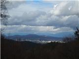
 | Ljubljana (Gruberjeva brv) - Orle
Orle is a settlement in the Municipality of Škofljica, located on a small hill northeast of the Ljubljana Marshes. A few meters below the highest...
1 h 45 min |
 | Lokvica - Veliki vrh (Črni hribi)
Veliki vrh is a 463-meter-high hill located in the Črni hribi ridge. From the summit, which has a summit logbox, there is no view due to the fore...
1 h 30 min |
 | Dragomer - Strmca (via Debeli hrib)
Strmca is a lesser-known forested hill located between the settlements of Brezje pri Dobrovi and Log pri Brezovici. Due to the forest cover, ther...
1 h 15 min |
 | Stainz bei Straden - Aussichtswarte Vulkanland (via Rosenberg)
The 41-meter-high lookout tower Aussichtswarte Vulkanland (or Aussichtswarte Frutten-Gießelsdorf) is located above the settlement Frutten-Gießels...
1 h 30 min |
 | Komare doline - Kuk
Kuk (also known as Ščukovec on some maps) is a 498-meter-high hill north of the village Movraž. From the summit, which features a small cross, th...
1 h 15 min |
 | Komare doline - Veliki Gradež
Veliki Gradež is a 507-meter-high rise between Zazid and Movraž. From the summit, amid expansive pastures, there is a fine view of the Primorska ...
1 h 30 min |
 | Svečina - Plački vrh
Plački vrh is a peak in Slovenske Gorice. It lies in the municipality of Kungota, right on the border with Austria.A 28-meter-high lookout tower ...
1 h 35 min |
 | Štore - Turn (Sveti Janez Krstnik) (via Kompole)
Turn is a peak above Štore - Šentjanž nad Štorami. Slightly below the summit, at the site of the former Prežin Castle, the Church of St. John the...
1 h 15 min |
 | Hunting cottage Muljava - Mali Petrovac (Petrova gora) (via Mali Velebit)
Mali Petrovac is a rather low hill located somewhere on the border between Banija and Kordun, as well as Pannonian Croatia and Gorski Kotar. The ...
1 h 15 min |
 | Malovše - Školj Svetega Pavla above Vrtovin
Školj sv. Pavla is located on a panoramic hill above the village of Vrtovin, which lies west of Ajdovščina. From the church, near which the logbo...
1 h 5 min |
 | Rdeči Kal - Ostri vrh (above Globodol) (via Velika raven)
Ostri vrh is a 523-meter-high peak located between Vrbovec, Rdeči Kal, Gorenji, Srednji, and Dolenji Globodol, Dolnji and Gornji Ajdovec, and Pod...
1 h 15 min |
 | Jama Pekel (parking lot) - Apno (via Pogorišče)
Apno is a 525-metre-high mountain located on the Ponikovski karst. The summit has some benches, a summit register box, but due to the forest ther...
1 h 25 min |
 | Gorjuša - Sveta Trojica (above Dob) (via Dobovlje)
Sveta Trojica is a village located southeast of Dob pri Domžalah. In the upper part of the village, on a scenic hill, stands the Church of the Ho...
1 h 50 min |
 | Gorica pri Slivnici - Church of St. Helena on Javor
The Church of St. Helena stands on Javor, just off the highest point of the nearby peak where there is also a summit register box and an NOB monu...
1 h 45 min |
 | Zagrad - Vipota (via crossing Ivankovič)
Vipota is a 532-meter-high peak south of Celje above the left bank of the Savinja River. Approaches to the summit are possible from several direc...
1 h 15 min |
 | Zgornje Poljčane - Ljubična gora
Ljubična gora is an elongated hill above the settlements of Ljubično, Zbelovo and Zbelovska gora. The peak is hidden in forest and not well visib...
1 h 15 min |
 | Velika Kostrevnica - Kožljevec
Kožljevec (also Kožlevec) is a 533-meter-high hill above Cerovica in the municipality of Šmartno pri Litiji. The forested summit features a logbo...
1 h 10 min |
 | Brezje pri Dobrovi - Vrh (Debeli hrib) (via Strmca)
Vrh is a 540-meter-high hill on the Debeli hrib ridge, which lies between the Ljubljana Marshes and the Horjulščica river valley. The view from t...
1 h 15 min |
 | Okrog (Lazar) - Zaplaz
Zaplaz is a 543-meter-high hill located above Čatež, a settlement best known as the endpoint of the Levstik Trail (From Litija to Čatež). The sum...
1 h 10 min |
 | Pliskovica - Volnik
Volnik (Monte Lanaro in Italian) is a 546 m high hill located near the village of Pliskovica on the Karst. At the summit there is a small tower, ...
1 h 30 min |
 | Wildon - Buchkogel (Wildoner Berg)
Buchkogel or Wildoner Berg is a 550-meter-high hill in southern Styria. Buchkogel together with the peaks Wildoner Schlossberg (450 m) and Bockbe...
1 h 30 min |
 | Žena Glava - Sveti Duh (Hum)
Sveti Duh is a chapel located northeast of Hum, the highest peak on Vis island, though it is under military control and inaccessible. From the ch...
1 h 45 min |
 | Bela - Čevo
Čevo is the eastern peak on Ivanščica. From the south it is a gentle hill, but from the north it descends very steeply into the valley. It is als...
1 h 45 min |
 | Gorica pri Slivnici - Rifnik
Rifnik is a 568-meter-high peak situated south of Šentjur pri Celju. The summit, known for its archaeological site, offers nice views towards Šen...
1 h 15 min |
 | Treskavac - Obzova
Obzova is the highest point on the island of Krk. Like the entire surrounding area, the summit is completely rocky. Interesting are the pools nea...
1 h 30 min |
 | Podčetrtek (Terme Olimia) - Zavetišče Šmarnica on Mala Rudnica (past castle Podčetrtek)
The Šmarnica shrine is located on Mala Rudnica within the Rudnica range, a smaller hill chain above Podčetrtek. From the shrine there opens a bea...
1 h 15 min |
| Podčetrtek (sveti Lovrenc) - Zavetišče Šmarnica on Mala Rudnica (past castle Podčetrtek)
The Šmarnica shrine is located on Mala Rudnica within the Rudnica range, a smaller hill chain above Podčetrtek. From the shrine there opens a bea...
1 h 5 min |
 | Olimje - Zavetišče Šmarnica on Mala Rudnica
The Šmarnica shrine is located on Mala Rudnica within the Rudnica range, a smaller hill chain above Podčetrtek. From the shrine there opens a bea...
1 h 45 min |
| Slake (Church of the Virgin Mary on Pesek) - Zavetišče Šmarnica on Mala Rudnica
The Šmarnica shrine is located on Mala Rudnica within the Rudnica range, a smaller hill chain above Podčetrtek. From the shrine there opens a bea...
1 h 35 min |
 | Dobrnič - Trebni vrh (via Šahovec)
Trebni vrh is a 581-meter-high hill located south or southwest of Trebnje. On the forested summit stands a bench, and nearby is a logbook box wit...
1 h 45 min |
 | Stojdraga (Glažuta) - Gradina Tuščak (via Tuščak)
Gradina Tuščak is an HPO point about 10 minutes off the Tuščak summit. The castle is believed to have been built at the end of the 12th or beginn...
1 h 20 min |
 | Ljubljana (Šentvid) - Toško Čelo
Toško Čelo is a 590-metre hill above the village of the same name. From the summit, or slightly below it, a beautiful view opens over part of Lju...
1 h 45 min |
 | Stogovci (Vabča vas) - Kerješetov vrh
Kerješetov vrh is a 590-meter-high hill located above the settlement of Jelovice. The summit is overgrown with forest, so there is no good view f...
1 h 30 min |
 | Bad Gleichenberg (Eichgraben Weg) - Gleichenberger Kogel (via Mühlsteinbruch)
Gleichenberger Kogel is a 598-meter-high mountain of volcanic origin located above Bad Gleichenberg in Styria....
1 h 10 min |
| Bad Gleichenberg (Eichgraben Weg) - Gleichenberger Kogel
Gleichenberger Kogel is a 598-meter-high mountain of volcanic origin located above Bad Gleichenberg in Styria....
1 h 5 min |
| Bad Gleichenberg (Eichgraben Weg) - Gleichenberger Kogel (via Steinriegel)
Gleichenberger Kogel is a 598-meter-high mountain of volcanic origin located above Bad Gleichenberg in Styria....
1 h 55 min |
 | Stojdraga (Glažuta) - Tuščak (Žumberačka gora)
Tuščak is a forested hill above the Bregana River valley on Žumberačka gora. The summit features a logbox....
1 h 10 min |
 | Griže - Dragov dom na Homu (direct path)
Dragov dom is located on a scenic hill south of Šempeter. From the summit, where there is also the Church of St. Magdalena, there is a fine panor...
1 h 30 min |
| Griže - Dragov dom na Homu (via Zahom)
Dragov dom is located on a scenic hill south of Šempeter. From the summit, where there is also the Church of St. Magdalena, there is a fine panor...
1 h 50 min |
| Griže - Dragov dom na Homu (via Lajnarjev hrib)
Dragov dom is located on a scenic hill south of Šempeter. From the summit, where there is also the Church of St. Magdalena, there is a fine panor...
1 h 40 min |
| Šešče pri Preboldu - Dragov dom na Homu (Brdovska pot)
Dragov dom is located on a scenic hill south of Šempeter. From the summit, where there is also the Church of St. Magdalena, there is a fine panor...
1 h 15 min |
 | Za koridorjem - Sabotin (on ridge)
Sabotin is a hill above Nova Gorica or, more precisely, above Solkan. Despite its modest height, it is an excellent viewpoint with views of the J...
1 h 15 min |
 | Bridge over Dušica - Bajturn (Zaplaški hrib) (on ridge)
Bajturn, or Zaplaški hrib, at 609 meters, is the highest peak in the Trebnje municipality. The summit features a pleasant bench with a table, a b...
1 h 20 min |
| Bridge over Dušica - Bajturn (Zaplaški hrib) (on north slope)
Bajturn, or Zaplaški hrib, at 609 meters, is the highest peak in the Trebnje municipality. The summit features a pleasant bench with a table, a b...
1 h 30 min |
| Okrog (Lazar) - Bajturn (Zaplaški hrib) (on ridge)
Bajturn, or Zaplaški hrib, at 609 meters, is the highest peak in the Trebnje municipality. The summit features a pleasant bench with a table, a b...
1 h 30 min |
| Okrog (Lazar) - Bajturn (Zaplaški hrib) (on north slope)
Bajturn, or Zaplaški hrib, at 609 meters, is the highest peak in the Trebnje municipality. The summit features a pleasant bench with a table, a b...
1 h 40 min |
 | Bad Gleichenberg (Sägewerk Weiss) - Stradner Kogel
Stradner Kogel is the highest hill in southeastern Styria, Austria. The hill is of volcanic origin, and the summit offers no views in any directi...
1 h 15 min |
| Haag - Stradner Kogel
Stradner Kogel is the highest hill in southeastern Styria, Austria. The hill is of volcanic origin, and the summit offers no views in any directi...
1 h 10 min |
 | Zgornje Poljčane - Rančka
Rančka is a 615-meter-high peak located west to southwest of Boč. Just below the summit is a stamp box with a bench nearby; the highest point its...
1 h 25 min |
 | Prebold - Žvajga (northern peak) (western path)
The northern peak of Žvajga is a 620-meter-high hill located south to southwest of Prebold and northwest of the slightly higher southern peak. A ...
1 h 5 min |
 | Podčetrtek (sveti Lovrenc) - Silavec (The Tower of Health and Joy on Rudnica) (past castle Podčetrtek)
Silavec is a 622-meter-high peak on Rudnica above Podčetrtek, on which stands a lookout tower slightly over 35 meters tall, offering a beautiful ...
1 h 25 min |
| Podčetrtek (sveti Lovrenc) - Silavec (The Tower of Health and Joy on Rudnica) (easier path)
Silavec is a 622-meter-high peak on Rudnica above Podčetrtek, on which stands a lookout tower slightly over 35 meters tall, offering a beautiful ...
1 h 15 min |
| Podčetrtek (sveti Lovrenc) - Silavec (The Tower of Health and Joy on Rudnica) (harder path)
Silavec is a 622-meter-high peak on Rudnica above Podčetrtek, on which stands a lookout tower slightly over 35 meters tall, offering a beautiful ...
1 h 15 min |
| Spodnje Tinsko - Silavec (The Tower of Health and Joy on Rudnica)
Silavec is a 622-meter-high peak on Rudnica above Podčetrtek, on which stands a lookout tower slightly over 35 meters tall, offering a beautiful ...
1 h 20 min |
| Olimje - Silavec (The Tower of Health and Joy on Rudnica) (past Koča pri čarovnici)
Silavec is a 622-meter-high peak on Rudnica above Podčetrtek, on which stands a lookout tower slightly over 35 meters tall, offering a beautiful ...
1 h 45 min |
| Olimje - Silavec (The Tower of Health and Joy on Rudnica) (harder path)
Silavec is a 622-meter-high peak on Rudnica above Podčetrtek, on which stands a lookout tower slightly over 35 meters tall, offering a beautiful ...
1 h 35 min |
| Olimje - Silavec (The Tower of Health and Joy on Rudnica) (easier path)
Silavec is a 622-meter-high peak on Rudnica above Podčetrtek, on which stands a lookout tower slightly over 35 meters tall, offering a beautiful ...
1 h 35 min |
| Slake (Church of the Virgin Mary on Pesek) - Silavec (The Tower of Health and Joy on Rudnica) (harder path)
Silavec is a 622-meter-high peak on Rudnica above Podčetrtek, on which stands a lookout tower slightly over 35 meters tall, offering a beautiful ...
1 h 25 min |
| Slake (Church of the Virgin Mary on Pesek) - Silavec (The Tower of Health and Joy on Rudnica) (easier path)
Silavec is a 622-meter-high peak on Rudnica above Podčetrtek, on which stands a lookout tower slightly over 35 meters tall, offering a beautiful ...
1 h 25 min |
 | Naraplje - Jelovice
Jelovice, at 623 meters, is the highest peak in the Haloze hills. The summit is accessible from several directions. It offers partial views towar...
1 h 40 min |
| Stogovci (Vabča vas) - Jelovice
Jelovice, at 623 meters, is the highest peak in the Haloze hills. The summit is accessible from several directions. It offers partial views towar...
1 h 40 min |
 | Podsreda - Rigelj
Rigelj is a 626-meter-high indistinct peak in the Orlice range, on which a few antennas stand....
1 h 15 min |
 | Grgar - Frančiškov hrib
Frančiškov hrib is a less prominent peak on Skalnica, whose highest point is the 681-meter-high Sveta Gora. From the panoramic summit, which feat...
1 h 15 min |
 | Povodje - Rašica (Vrh Staneta Kosca)
Vrh Staneta Kosca, better known as Rašica, is located north of Ljubljana, more precisely above the villages of Rašica and Dobeno. From the summit...
1 h 30 min |
 | Jablje Castle - Rašica (Vrh Staneta Kosca)
Vrh Staneta Kosca, better known as Rašica, is located north of Ljubljana, more precisely above the villages of Rašica and Dobeno. From the summit...
1 h 20 min |
| Loka - Rašica (Vrh Staneta Kosca)
Vrh Staneta Kosca, better known as Rašica, is located north of Ljubljana, more precisely above the villages of Rašica and Dobeno. From the summit...
1 h 20 min |
 | Selo pri Vodicah - Rašica (Vrh Staneta Kosca) (old path)
Vrh Staneta Kosca, better known as Rašica, is located north of Ljubljana, more precisely above the villages of Rašica and Dobeno. From the summit...
1 h 15 min |
 | Selo pri Vodicah - Rašica (Vrh Staneta Kosca) (by road)
Vrh Staneta Kosca, better known as Rašica, is located north of Ljubljana, more precisely above the villages of Rašica and Dobeno. From the summit...
1 h 20 min |
 | Selo pri Vodicah - Rašica (Vrh Staneta Kosca)
Vrh Staneta Kosca, better known as Rašica, is located north of Ljubljana, more precisely above the villages of Rašica and Dobeno. From the summit...
1 h 30 min |
 | Prevala - Škabrijel (via Veliki hrib)
Škabrijel is a hill northeast of the town of Gorica. Since the vegetation on the summit was cleared and a tall metal observation tower was erecte...
1 h 5 min |
 | Rimske Toplice - Stražnik (via Borovo)
Stražnik is a 648-meter peak south of Rimske Toplice. The summit features a bench and summit register box, with a cross erected in 2021 about 50 ...
1 h 20 min |
 | Šentjur - Resevna
Resevna is a peak situated south of Šentjur. At the summit stands a 20-meter-high observation tower offering beautiful views that extend far acro...
1 h 30 min |
| Jakob pri Šentjurju - Resevna
Resevna is a peak situated south of Šentjur. At the summit stands a 20-meter-high observation tower offering beautiful views that extend far acro...
1 h 30 min |
 | Šentjur (center) - Resevna (via Krajnče)
Resevna is a peak situated south of Šentjur. At the summit stands a 20-meter-high observation tower offering beautiful views that extend far acro...
1 h 35 min |
| Šentjur (center) - Resevna (steep path)
Resevna is a peak situated south of Šentjur. At the summit stands a 20-meter-high observation tower offering beautiful views that extend far acro...
1 h 30 min |
| Šentjur (center) - Resevna (gentle path)
Resevna is a peak situated south of Šentjur. At the summit stands a 20-meter-high observation tower offering beautiful views that extend far acro...
1 h 35 min |
 | Kozje - Raskože (Bohor) (via Vetrnik)
Raskože is a 650-meter-high peak on the eastern part of Bohor. Some people also call this area Vetrnik. The south side of the peak is dominated b...
1 h 15 min |
 | Grgar - Vodice (via Ranjeke)
Vodice (according to some records also Sveti Jakob) is a peak on the western part of the Banjška planota plateau. From the summit, which features...
1 h 30 min |
 | Pišece (Pri mlinu) - Velika Vagla
Velika Vagla is a 667-meter-high peak located in the Orlice mountain range, specifically along the marked trail from Pišece to Veliki Špiček....
1 h 5 min |
 | Povodje - Šmarna gora
Šmarna gora is a 669 m peak northwest of Slovenia's capital. From the summit, with its restaurant and church, there is a beautiful view over Gore...
1 h 30 min |
 | Povodje - Šmarna gora (via Sedlo)
Šmarna gora is a 669 m peak northwest of Slovenia's capital. From the summit, with its restaurant and church, there is a beautiful view over Gore...
1 h 35 min |
| Šmartno - Šmarna gora (path around Šmarna gora)
Šmarna gora is a 669 m peak northwest of Slovenia's capital. From the summit, with its restaurant and church, there is a beautiful view over Gore...
1 h 30 min |
 | Vikrče - Šmarna gora (via Zatrep)
Šmarna gora is a 669 m peak northwest of Slovenia's capital. From the summit, with its restaurant and church, there is a beautiful view over Gore...
1 h 10 min |
 | Povodje - Šmarna gora (Partizanska steza)
Šmarna gora is a 669 m peak northwest of Slovenia's capital. From the summit, with its restaurant and church, there is a beautiful view over Gore...
1 h 45 min |
| Skaručna - Šmarna gora
Šmarna gora is a 669 m peak northwest of Slovenia's capital. From the summit, with its restaurant and church, there is a beautiful view over Gore...
1 h 30 min |
| Skaručna - Šmarna gora (via Sedlo)
Šmarna gora is a 669 m peak northwest of Slovenia's capital. From the summit, with its restaurant and church, there is a beautiful view over Gore...
1 h 35 min |
| Skaručna - Šmarna gora (Partizanska steza)
Šmarna gora is a 669 m peak northwest of Slovenia's capital. From the summit, with its restaurant and church, there is a beautiful view over Gore...
1 h 45 min |
| Vikrče - Šmarna gora (Mazijeva steza)
Šmarna gora is a 669 m peak northwest of Slovenia's capital. From the summit, with its restaurant and church, there is a beautiful view over Gore...
1 h 35 min |
 | Lipa - Šmarna gora (by road)
Šmarna gora is a 669 m peak northwest of Slovenia's capital. From the summit, with its restaurant and church, there is a beautiful view over Gore...
1 h 5 min |
 | Vikrče - Šmarna gora (Kovačeva steza)
Šmarna gora is a 669 m peak northwest of Slovenia's capital. From the summit, with its restaurant and church, there is a beautiful view over Gore...
1 h 10 min |
| Vikrče - Šmarna gora (learning trail)
Šmarna gora is a 669 m peak northwest of Slovenia's capital. From the summit, with its restaurant and church, there is a beautiful view over Gore...
1 h 20 min |
| Spodnje Pirniče - Šmarna gora (Kovačeva steza)
Šmarna gora is a 669 m peak northwest of Slovenia's capital. From the summit, with its restaurant and church, there is a beautiful view over Gore...
1 h 10 min |
| Spodnje Pirniče - Šmarna gora (learning trail)
Šmarna gora is a 669 m peak northwest of Slovenia's capital. From the summit, with its restaurant and church, there is a beautiful view over Gore...
1 h 10 min |
| Tourist farm Žurej - Žusem (Panoramska pot - old route)
Žusem is a 669-meter-high hill with a rich history and great potential for the future. It forms the northern edge of Kozjansko, and its name deri...
1 h 40 min |
 | Tourist farm Žurej - Žusem (Panoramska pot)
Žusem is a 669-meter-high hill with a rich history and great potential for the future. It forms the northern edge of Kozjansko, and its name deri...
1 h 40 min |
 | Loka pri Žusmu (Žamerk) - Žusem
Žusem is a 669-meter-high hill with a rich history and great potential for the future. It forms the northern edge of Kozjansko, and its name deri...
1 h 20 min |
 | Loka pri Žusmu (Žamerk) - Žusem (via Dobrina)
Žusem is a 669-meter-high hill with a rich history and great potential for the future. It forms the northern edge of Kozjansko, and its name deri...
1 h 30 min |
 | Povodje - Grmada
Grmada is a 676-meter-high mountain located west of the much more visited Šmarna gora. From the summit, which has a small takeoff area, a beautif...
1 h 50 min |
| Vikrče - Grmada (via Zatrep)
Grmada is a 676-meter-high mountain located west of the much more visited Šmarna gora. From the summit, which has a small takeoff area, a beautif...
1 h 15 min |
| Skaručna - Grmada
Grmada is a 676-meter-high mountain located west of the much more visited Šmarna gora. From the summit, which has a small takeoff area, a beautif...
1 h 50 min |
 | Vikrče - Grmada (Mazijeva steza)
Grmada is a 676-meter-high mountain located west of the much more visited Šmarna gora. From the summit, which has a small takeoff area, a beautif...
1 h 5 min |
| Tacen - Grmada (Mazijeva steza)
Grmada is a 676-meter-high mountain located west of the much more visited Šmarna gora. From the summit, which has a small takeoff area, a beautif...
1 h 10 min |
| Tacen (Sveti Jurij) - Grmada
Grmada is a 676-meter-high mountain located west of the much more visited Šmarna gora. From the summit, which has a small takeoff area, a beautif...
1 h 5 min |
 | Vikrče - Grmada (Kovačeva steza)
Grmada is a 676-meter-high mountain located west of the much more visited Šmarna gora. From the summit, which has a small takeoff area, a beautif...
1 h 10 min |
 | Lipa - Grmada (by road)
Grmada is a 676-meter-high mountain located west of the much more visited Šmarna gora. From the summit, which has a small takeoff area, a beautif...
1 h 10 min |
| Vikrče - Grmada (on Kovačeva steza and over Sedlo)
Grmada is a 676-meter-high mountain located west of the much more visited Šmarna gora. From the summit, which has a small takeoff area, a beautif...
1 h 15 min |
| Vikrče - Grmada (learning trail)
Grmada is a 676-meter-high mountain located west of the much more visited Šmarna gora. From the summit, which has a small takeoff area, a beautif...
1 h 20 min |
| Spodnje Pirniče - Grmada (learning trail)
Grmada is a 676-meter-high mountain located west of the much more visited Šmarna gora. From the summit, which has a small takeoff area, a beautif...
1 h 15 min |
| Spodnje Pirniče - Grmada (on Kovačeva steza and over Sedlo)
Grmada is a 676-meter-high mountain located west of the much more visited Šmarna gora. From the summit, which has a small takeoff area, a beautif...
1 h 15 min |