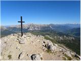
 | Medvedova konta - Debela peč
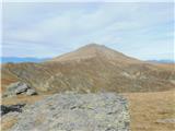
Debela peč is a 2014 m high mountain that rises steeply above the Krma valley on one side and gently descends towards the expansive Pokljuka fore...
2 h 15 min |
 | Pri Rupah - Debela peč
Debela peč is a 2014 m high mountain that rises steeply above the Krma valley on one side and gently descends towards the expansive Pokljuka fore...
2 h 15 min |
| Strmec - Debela peč (via Spodnja Brda)
Debela peč is a 2014 m high mountain that rises steeply above the Krma valley on one side and gently descends towards the expansive Pokljuka fore...
2 h 45 min |
| Strmec - Debela peč
Debela peč is a 2014 m high mountain that rises steeply above the Krma valley on one side and gently descends towards the expansive Pokljuka fore...
2 h 30 min |
 | Strmec - Debela peč (old path)
Debela peč is a 2014 m high mountain that rises steeply above the Krma valley on one side and gently descends towards the expansive Pokljuka fore...
2 h 15 min |
 | Rudno polje - Debela peč
Debela peč is a 2014 m high mountain that rises steeply above the Krma valley on one side and gently descends towards the expansive Pokljuka fore...
3 h 15 min |
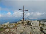
 | Planina Podvežak - Veliki vrh (Veža) (via Prag)
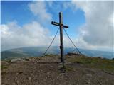
Veliki Vrh is a 2,110-metre-high mountain located in the central part of the Dleskovec Plateau. From the summit, where there are two registration...
2 h 20 min |
 | Planina Ravne - Veliki vrh (Veža) (via Zelene trate)
Veliki Vrh is a 2,110-metre-high mountain located in the central part of the Dleskovec Plateau. From the summit, where there are two registration...
2 h 15 min |
| Planina Ravne - Veliki vrh (Veža) (via Dolga trata)
Veliki Vrh is a 2,110-metre-high mountain located in the central part of the Dleskovec Plateau. From the summit, where there are two registration...
2 h 30 min |
| Kraljev dol - Veliki vrh (Veža) (via Planina Vodole)
Veliki Vrh is a 2,110-metre-high mountain located in the central part of the Dleskovec Plateau. From the summit, where there are two registration...
2 h 35 min |
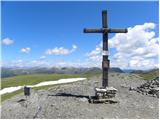
 | Waldheimhütte - Zirbitzkogel (Direct way)
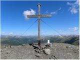
Zirbitzkogel, at 2,396 m, is the highest peak of the Labotniške Alpe / Seetaler Alpen. From the summit, where a cross and a panorama board stand,...
2 h 17 min |
 | Winterleiten parking - Zirbitzkogel
Zirbitzkogel, at 2,396 m, is the highest peak of the Labotniške Alpe / Seetaler Alpen. From the summit, where a cross and a panorama board stand,...
2 h 17 min |
 | Tonnerhütte - Zirbitzkogel
Zirbitzkogel, at 2,396 m, is the highest peak of the Labotniške Alpe / Seetaler Alpen. From the summit, where a cross and a panorama board stand,...
2 h 32 min |
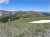
 | Waldheimhütte - Fuchskogel (via Wildsee)
Fuchskogel is a peak south of Zirbitzkogel in the Seetaler Alpen mountain group. The summit is broad and mostly covered in grass. More precisely,...
2 h 45 min |
 | Tonnerhütte - Fuchskogel
Fuchskogel is a peak south of Zirbitzkogel in the Seetaler Alpen mountain group. The summit is broad and mostly covered in grass. More precisely,...
2 h 20 min |
 | Tonnerhütte - Scharfes Eck
Scharfes Eck is a peak on which stands an Austrian meteorological radar station. From the summit, there is a beautiful view of the neighbouring p...
3 h |
 | Salzstiegelhaus - Weißenstein (Packalpe)
Weißenstein is a grassy mountain crisscrossed with wire fences. From its indistinct summit, there is a nice view of the neighboring Ameringkogel ...
2 h 20 min |
 | Salzstiegelhaus - Ameringkogel (Packalpe)
Ameringkogel is a grassy summit with a cross and summit register. At 2,187 meters, it is the highest peak of the Packalpe. In good visibility, th...
2 h 30 min |
 | Walischeben - Großenberg (Packalpe) (via Ameringkogel)
Großenberg, also known as Größing, is the northernmost two-thousander in the Packalpe mountain group. From its expansive grassy summit, where a t...
2 h 25 min |
| Walischeben - Großenberg (Packalpe) (below the Ameringkogel summit)
Großenberg, also known as Größing, is the northernmost two-thousander in the Packalpe mountain group. From its expansive grassy summit, where a t...
2 h 20 min |
| Salzstiegelhaus - Großenberg (Packalpe)
Großenberg, also known as Größing, is the northernmost two-thousander in the Packalpe mountain group. From its expansive grassy summit, where a t...
2 h 55 min |
 | Jakobe - Petzen (Kordeschkopf) (Peca (Kordeževa glava)) (easy path)
Kordeževa glava, better known as Peca, is the highest peak of the Peca range. It is located on the border with Austria above the Mežiška dolina v...
2 h 15 min |
 | Planina Ravne - Velika Zelenica (via Zelene trate)
Velika Zelenica is the highest peak of the Dleskovška plateau, offering panoramic views accordingly. The nearby Ojstrica stands out most prominen...
2 h 15 min |
 | Planina Podvežak - Velika Zelenica (via Prag)
Velika Zelenica is the highest peak of the Dleskovška plateau, offering panoramic views accordingly. The nearby Ojstrica stands out most prominen...
2 h 30 min |
| Planina Ravne - Velika Zelenica (via Dolga trata)
Velika Zelenica is the highest peak of the Dleskovška plateau, offering panoramic views accordingly. The nearby Ojstrica stands out most prominen...
2 h 30 min |
 | Weinebene - Großer Speikkogel (Koralpe) (panoramic path)
Großer Speikkogel is, at 2,140 meters, the highest peak of Golica/Koralpe, a range east of Volšperk/Wolfsberg. From the summit, where a cross and...
3 h |
| Weinebene - Großer Speikkogel (Koralpe) (via Schäferkreuz)
Großer Speikkogel is, at 2,140 meters, the highest peak of Golica/Koralpe, a range east of Volšperk/Wolfsberg. From the summit, where a cross and...
3 h 15 min |
| Smučišče Koralpe (Koralpenparkplatz) - Großer Speikkogel (Koralpe) (via Großhöllerhütte)
Großer Speikkogel is, at 2,140 meters, the highest peak of Golica/Koralpe, a range east of Volšperk/Wolfsberg. From the summit, where a cross and...
3 h |
 | parking below Weinebene - Großer Speikkogel (Koralpe) (panoramic path)
Großer Speikkogel is, at 2,140 meters, the highest peak of Golica/Koralpe, a range east of Volšperk/Wolfsberg. From the summit, where a cross and...
3 h |
| parking below Weinebene - Großer Speikkogel (Koralpe) (via cross Schäferkreuz)
Großer Speikkogel is, at 2,140 meters, the highest peak of Golica/Koralpe, a range east of Volšperk/Wolfsberg. From the summit, where a cross and...
3 h 15 min |
| parking below Weinebene - Großer Speikkogel (Koralpe) (via Grünangerhütte)
Großer Speikkogel is, at 2,140 meters, the highest peak of Golica/Koralpe, a range east of Volšperk/Wolfsberg. From the summit, where a cross and...
3 h 10 min |
 | Weinebene - Großer Speikkogel (Koralpe) (above Pomswasserfall)
Großer Speikkogel is, at 2,140 meters, the highest peak of Golica/Koralpe, a range east of Volšperk/Wolfsberg. From the summit, where a cross and...
3 h 45 min |
| Smučišče Koralpe (Koralpenparkplatz) - Großer Speikkogel (Koralpe) (by the edge of the Großes Kar plateau)
Großer Speikkogel is, at 2,140 meters, the highest peak of Golica/Koralpe, a range east of Volšperk/Wolfsberg. From the summit, where a cross and...
2 h 15 min |
 | Ladinger Straße - Ladinger Spitz (Saualpe) (via Ladinger Hütte)
Velika Svinja, known in German as Ladinger Spitz, is at 2079 m the highest peak of the Svinja / Saualpe mountain range. From the summit, which ha...
3 h |
 | Ladinger Straße - Ladinger Spitz (Saualpe) (via Wolfsberger Hütte)
Velika Svinja, known in German as Ladinger Spitz, is at 2079 m the highest peak of the Svinja / Saualpe mountain range. From the summit, which ha...
2 h 50 min |
 | Klippitztörl - Ladinger Spitz (Saualpe)
Velika Svinja, known in German as Ladinger Spitz, is at 2079 m the highest peak of the Svinja / Saualpe mountain range. From the summit, which ha...
3 h 35 min |
 | Ladinger Straße - Ladinger Spitz (Saualpe) (via Offnerhütte)
Velika Svinja, known in German as Ladinger Spitz, is at 2079 m the highest peak of the Svinja / Saualpe mountain range. From the summit, which ha...
2 h 25 min |
| Ladinger Straße - Ladinger Spitz (Saualpe) (via Zechhütte)
Velika Svinja, known in German as Ladinger Spitz, is at 2079 m the highest peak of the Svinja / Saualpe mountain range. From the summit, which ha...
2 h 20 min |
 | Heidi Alm - Klomnock
Klomnock is the house mountain of the Nockalmstraße alpine road, leading to the Schiestelscharte pass (2,024 m). From the summit, where a cross s...
2 h 15 min |
 | Turracher Höhe - Kaserhöhe
Kaserhöhe is a panoramic peak located in Austrian Carinthia in the heart of the Gurktal Alps. On the spacious summit, which is partly covered in ...
2 h 20 min |
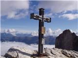
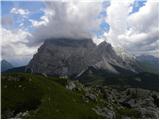
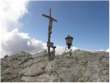 | Passo Falzarego - Lagazuoi Piccolo (normal way)
Lagazuoi Piccolo is a 2,778 m high mountain located north of the Passo Falzarego pass (2,105 m). From the summit, where a cross stands, there is ...
2 h 15 min |
| Passo Valparola - Lagazuoi Piccolo
Lagazuoi Piccolo is a 2,778 m high mountain located north of the Passo Falzarego pass (2,105 m). From the summit, where a cross stands, there is ...
2 h 45 min |
 | Rifugio Auronzo - Croda Fiscalina di Mezzo / Oberbachernspitze
Croda Fiscalina di Mezzo, or in German Oberbachernspitze, is a 2675-meter-high mountain located in the heart of the Dolomiti di Sesto / Sextner D...
2 h 30 min |
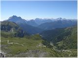
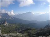 | Passo Falzarego - Rifugio Nuvolau
The mountain hut Rifugio Nuvolau is located on its eponymous summit, southwest of Cortina d'Ampezzo. On clear days, it offers a breathtaking pano...
2 h 15 min |
 | Rifugio Bai de Dones - Rifugio Nuvolau (Trincee)
The mountain hut Rifugio Nuvolau is located on its eponymous summit, southwest of Cortina d'Ampezzo. On clear days, it offers a breathtaking pano...
2 h 50 min |
| Rifugio Bai de Dones - Rifugio Nuvolau (via Rifugio Cinque Torri)
The mountain hut Rifugio Nuvolau is located on its eponymous summit, southwest of Cortina d'Ampezzo. On clear days, it offers a breathtaking pano...
2 h 35 min |
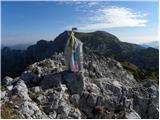
 | Planina Podvežak - Mala Ojstrica
Mala Ojstrica is an indistinct peak located between Ojstrica, Molička Planina mountain pasture, and Korošica. From the summit, which features a l...
2 h 30 min |
 | Planina Ravne - Mala Ojstrica (via Dolga trata)
Mala Ojstrica is an indistinct peak located between Ojstrica, Molička Planina mountain pasture, and Korošica. From the summit, which features a l...
3 h 45 min |
 | Rifugio Selvapiana I.Lunelli - Croda Sora I Colesei / Arzalpenkopf (via Forcella Popera)
Croda Sora I Colesei (German: Arzalpenkopf) is a 2,321-meter-high mountain on the eastern edge of the Sexten Dolomites (Dolomiti di Sesto). The s...
2 h 30 min |
| Rifugio Selvapiana I.Lunelli - Croda Sora I Colesei / Arzalpenkopf (via Belvedere)
Croda Sora I Colesei (German: Arzalpenkopf) is a 2,321-meter-high mountain on the eastern edge of the Sexten Dolomites (Dolomiti di Sesto). The s...
2 h 30 min |
 | Heidi Alm - Mallnock
Mallnock is a 2226 m high peak located north of the settlement St. Oswald in the Krške Alpe. From the summit, where a cross stands, a beautiful v...
2 h 30 min |
 | Heidi Alm - Mallnock (via Klomnock)
Mallnock is a 2226 m high peak located north of the settlement St. Oswald in the Krške Alpe. From the summit, where a cross stands, a beautiful v...
2 h 45 min |
 | Rifugio Rio Gere - Rifugio Tondi
Rifugio Tondi is situated a few meters below the summit of Monte Ciasadio, the highest point of the Faloria ski slope. From the hut, there is a v...
2 h 15 min |
 | Passo Staulanza - Monte Pena
Monte Pena is a 2,196-meter-high mountain in the Pelmo group. From its summit, topped by a cross, there are superb views of nearby Monte Pelmo an...
3 h 30 min |
 | Rifugio Valparola - Setsas
The Setsas peak is located west of the Passo Valparola pass and is somewhat distant from the highest summits. Precisely because of this remotenes...
2 h 30 min |
 | Malga Crocifisso - Col de Valvacin
Col de Valvacin is a 2,372-meter-high peak on the west side of the Marmolada group near the Buffaure ski slopes. Rifugio el Zedron mountain hut i...
2 h 15 min |
 | Klippitztörl - Forstalpe (Saualpe) (via Geierkogel)
Forstalpe is an indistinct peak in the massif of Svinška planina / Saualpe. The stamp for Forstalpe is located in an interesting natural window, ...
2 h 10 min |
 | Klippitztörl - Kienberg (Saualpe) (via Geierkogel)
Kienberg is a 2,050-meter-high peak in the massif of Svinška planina / Saualpe. From the grassy summit, a beautiful view opens up over a larger p...
2 h 50 min |
| Klippitztörl - Kienberg (Saualpe)
Kienberg is a 2,050-meter-high peak in the massif of Svinška planina / Saualpe. From the grassy summit, a beautiful view opens up over a larger p...
2 h 20 min |
 | Klippitztörl - Gertrusk (Saualpe) (via Geierkogel)
Gertrusk is a panoramic two-thousander in the central part of the Saualpe. A cross stands on the summit, next to it a summit register box with a ...
3 h 35 min |
| Klippitztörl - Gertrusk (Saualpe)
Gertrusk is a panoramic two-thousander in the central part of the Saualpe. A cross stands on the summit, next to it a summit register box with a ...
3 h 5 min |
| Vitlenica - Veliki Vilinac (Vitlenica - Vilinac)
Veliki Vilinac is one of the peaks of the Čvrsnica mountain range, located west of Jablanica in Blidinje Nature Park. Čvrsnica is bounded by the ...
3 h |
 | Sella di Razzo - Clapsavon (via 210)
Clapsavon is a 2,462-meter-high mountain in the Carnic Alps in Italy. It lies about an hour's walk west of the 2,474-meter-high Bivera. Both peak...
3 h |
 | parking below Weinebene - Krakaberg (Golica / Koralpe) (panoramic path)
Krakaberg is a 2,070-meter-high peak located south of Großer Speikkogel, the highest peak of Golica / Koralpe. From the summit, a nice view opens...
3 h 10 min |
 | Weinebene - Steinschneider (via Großes Kar)
Steinschneider is a 2070-meter-high peak in the Golica / Koralpe mountain range, situated northwest of Großer Speikkogel, the highest peak of the...
3 h 15 min |
| parking below Weinebene - Steinschneider (via Großes Kar)
Steinschneider is a 2070-meter-high peak in the Golica / Koralpe mountain range, situated northwest of Großer Speikkogel, the highest peak of the...
3 h 15 min |
| Weinebene - Steinschneider (above Pomswasserfall)
Steinschneider is a 2070-meter-high peak in the Golica / Koralpe mountain range, situated northwest of Großer Speikkogel, the highest peak of the...
3 h 20 min |
| parking below Weinebene - Steinschneider (above Pomswasserfall)
Steinschneider is a 2070-meter-high peak in the Golica / Koralpe mountain range, situated northwest of Großer Speikkogel, the highest peak of the...
3 h 20 min |
 | Ladinger Straße - Sandkogel (via Offnerhütte)
Sandkogel is an indistinct panoramic peak rising to 2011 meters in the Svinja range....
2 h 20 min |
| Ladinger Straße - Sandkogel (via Zechhütte)
Sandkogel is an indistinct panoramic peak rising to 2011 meters in the Svinja range....
2 h 15 min |