 | Tomčeva koča na Poljški planini - Begunjščica
Begunjščica is a mountain range in the Karawanks east of Stol. Its highest peak is Veliki Vrh, which at over 2,000 m offers a fine view across ce...
2 h 50 min |
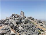
 | Valvasorjev dom pod Stolom - Hochstuhl/Stol (Zabreška way)
Stol is, at 2,236 m, the highest peak in the Karawanks. From the summit, which has a registration box and stamp, a beautiful view opens onto the ...
3 h 20 min |
 | Valvasorjev dom pod Stolom - Hochstuhl/Stol (Žirovniška way)
Stol is, at 2,236 m, the highest peak in the Karawanks. From the summit, which has a registration box and stamp, a beautiful view opens onto the ...
3 h |
 | Tinčkova koča - Hochstuhl/Stol (via Smokuška planina)
Stol is, at 2,236 m, the highest peak in the Karawanks. From the summit, which has a registration box and stamp, a beautiful view opens onto the ...
4 h 15 min |
 | Razpotje Vragovec - Hochstuhl/Stol (via Zabreška planina)
Stol is, at 2,236 m, the highest peak in the Karawanks. From the summit, which has a registration box and stamp, a beautiful view opens onto the ...
3 h |
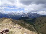
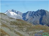
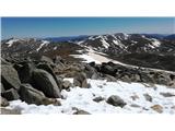
 | Globoka dolina - Veliki vrh (Košuta)
Veliki Vrh, at 2,088 m, is the westernmost two-thousander in Slovenia's longest ridge, the Košuta. From the summit, which has a registration box ...
3 h |
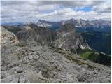
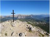
 | Dom pod Storžičem - Storžič (through southwest groove)
Storžič is a 2132 m high mountain located in the western part of the Kamnik-Savinja Alps. From the summit, where there is a cross, a beautiful vi...
3 h 50 min |
 | Bukovnik - Velika Raduha (via Durce)
Velika Raduha, at 2062 m, is the highest peak of the Raduha range, which rises steeply east of Robanov Kot. From the summit, with its registratio...
2 h 50 min |
 | Radušnik - Velika Raduha
Velika Raduha, at 2062 m, is the highest peak of the Raduha range, which rises steeply east of Robanov Kot. From the summit, with its registratio...
3 h 10 min |
| Planina Kosmačeve Rastke - Velika Raduha
Velika Raduha, at 2062 m, is the highest peak of the Raduha range, which rises steeply east of Robanov Kot. From the summit, with its registratio...
2 h 55 min |
 | Planina Vodol - Velika Raduha
Velika Raduha, at 2062 m, is the highest peak of the Raduha range, which rises steeply east of Robanov Kot. From the summit, with its registratio...
2 h 40 min |
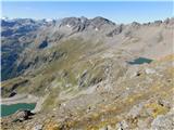
 | Planina Blato - Mala Tičarica (via Štapce)
Mala Tičarica is a highly panoramic mountain above the Twin Triglav Lakes. From the summit there is a beautiful view toward the Koča pri Triglavs...
3 h 25 min |
 | End of road on Vogar - Mala Tičarica (via Štapce)
Mala Tičarica is a highly panoramic mountain above the Twin Triglav Lakes. From the summit there is a beautiful view toward the Koča pri Triglavs...
3 h 30 min |
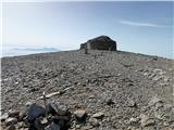
 | Valvasorjev dom - Prešernova koča na Stolu (Zabreška way)
The Prešernova koča na Stolu mountain hut is located just a few metres below the summit of the 2198 m high Mali Stol. From the hut or the nearby ...
3 h 5 min |
 | Valvasorjev dom - Prešernova koča na Stolu (Žirovniška way)
The Prešernova koča na Stolu mountain hut is located just a few metres below the summit of the 2198 m high Mali Stol. From the hut or the nearby ...
2 h 45 min |
 | Razpotje Vragovec - Prešernova koča na Stolu (via Zabreška planina)
The Prešernova koča na Stolu mountain hut is located just a few metres below the summit of the 2198 m high Mali Stol. From the hut or the nearby ...
2 h 45 min |
 | Kriška planina - Kalški greben (via planina Koren)
Kalški greben is a 2224 m high peak and the highest point of the ridge bearing the same name. From the summit, where there is a summit register a...
3 h 45 min |
| Dom na Gospincu - Kalški greben (via Dolga Njiva)
Kalški greben is a 2224 m high peak and the highest point of the ridge bearing the same name. From the summit, where there is a summit register a...
3 h 20 min |
| Planina Jezerca - Kalški greben (via planina Koren)
Kalški greben is a 2224 m high peak and the highest point of the ridge bearing the same name. From the summit, where there is a summit register a...
4 h |
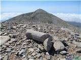
 | Kraljev dol - Veliki vrh (Veža) (via Planina Vodole)
Veliki Vrh is a 2,110-metre-high mountain located in the central part of the Dleskovec Plateau. From the summit, where there are two registration...
2 h 35 min |
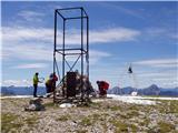
 | Zell-Schaida - Hochobir (Ojstrc)
Ojstrc (Hochobir) is the highest peak of the smaller Obir range. It is located west of Železna Kapla (Eisenkappel) on the Austrian side of the Ka...
3 h |
 | Waldheimhütte - Zirbitzkogel (via Wildsee)
Zirbitzkogel, at 2,396 m, is the highest peak of the Labotniške Alpe / Seetaler Alpen. From the summit, where a cross and a panorama board stand,...
3 h 32 min |
 | Tonnerhütte - Zirbitzkogel
Zirbitzkogel, at 2,396 m, is the highest peak of the Labotniške Alpe / Seetaler Alpen. From the summit, where a cross and a panorama board stand,...
2 h 32 min |
| Waldheimhütte - Zirbitzkogel (via Rothaidenhütte)
Zirbitzkogel, at 2,396 m, is the highest peak of the Labotniške Alpe / Seetaler Alpen. From the summit, where a cross and a panorama board stand,...
3 h 7 min |
| Waldheimhütte - Zirbitzkogel (via Lavantsee)
Zirbitzkogel, at 2,396 m, is the highest peak of the Labotniške Alpe / Seetaler Alpen. From the summit, where a cross and a panorama board stand,...
2 h 47 min |
 | Waldheimhütte - Scharfes Eck (Direct way)
Scharfes Eck is a peak on which stands an Austrian meteorological radar station. From the summit, there is a beautiful view of the neighbouring p...
2 h 45 min |
| Tonnerhütte - Scharfes Eck
Scharfes Eck is a peak on which stands an Austrian meteorological radar station. From the summit, there is a beautiful view of the neighbouring p...
3 h |
 | Salzstiegelhaus - Ameringkogel (Packalpe)
Ameringkogel is a grassy summit with a cross and summit register. At 2,187 meters, it is the highest peak of the Packalpe. In good visibility, th...
2 h 30 min |
 | Salzstiegelhaus - Großenberg (Packalpe) (via Ameringkogel)
Großenberg, also known as Größing, is the northernmost two-thousander in the Packalpe mountain group. From its expansive grassy summit, where a t...
3 h |
| Salzstiegelhaus - Großenberg (Packalpe)
Großenberg, also known as Größing, is the northernmost two-thousander in the Packalpe mountain group. From its expansive grassy summit, where a t...
2 h 55 min |
 | Nassfeld - Monte Cavallo / Rosskofel (via Sella di Aip / Rudnig sattel)
Konjski Špik / Monte Cavallo di Pontebba / Rosskofel is a 2,240-meter-high and highly panoramic mountain in the main ridge of the Carnic Alps in ...
4 h |
 | Koprein-Petzen - Petzen (Kordeschkopf) (Peca (Kordeževa glava))
Kordeževa glava, better known as Peca, is the highest peak of the Peca range. It is located on the border with Austria above the Mežiška dolina v...
4 h |
 | Rudnik v Topli - Petzen (Kordeschkopf) (Peca (Kordeževa glava)) (via hut, easy)
Kordeževa glava, better known as Peca, is the highest peak of the Peca range. It is located on the border with Austria above the Mežiška dolina v...
3 h 30 min |
| Pod Peco / Koprein-Petzen - Petzen (Kordeschkopf) (Peca (Kordeževa glava)) (slovenska pot)
Kordeževa glava, better known as Peca, is the highest peak of the Peca range. It is located on the border with Austria above the Mežiška dolina v...
3 h 50 min |
| Koprivna (Kumer) - Petzen (Kordeschkopf) (Peca (Kordeževa glava))
Kordeževa glava, better known as Peca, is the highest peak of the Peca range. It is located on the border with Austria above the Mežiška dolina v...
3 h 25 min |
 | Oberfresen (Brendlwald) - Großer Speikkogel (Koralpe) (lower path)
Großer Speikkogel is, at 2,140 meters, the highest peak of Golica/Koralpe, a range east of Volšperk/Wolfsberg. From the summit, where a cross and...
4 h 15 min |
| Oberfresen (Brendlwald) - Großer Speikkogel (Koralpe) (upper path)
Großer Speikkogel is, at 2,140 meters, the highest peak of Golica/Koralpe, a range east of Volšperk/Wolfsberg. From the summit, where a cross and...
3 h 45 min |
| Glashütten - Großer Speikkogel (Koralpe)
Großer Speikkogel is, at 2,140 meters, the highest peak of Golica/Koralpe, a range east of Volšperk/Wolfsberg. From the summit, where a cross and...
3 h 55 min |
 | Goldberg - Jaukenstöckl
Jaukenstöckl is a 2209 m high peak on the western side of the panoramic Jauken ridge. From the summit, where a statue of the Virgin Mary stands, ...
3 h 45 min |
 | Goldberg - Jaukenhöhe
Jaukenhöhe is a little-visited peak in the Jauken ridge. It lies west of Torkofel, the highest point in the ridge at 2276 m. The grassy, steep su...
3 h 45 min |
 | Etrachsee - Bauleiteck
Bauleiteck is a panoramic peak located on the eastern part of the Schladminger Tauern mountain group. From the summit, where a cross stands, ther...
3 h 15 min |
 | Prebersee - Preber
Preber is a 2740 m high peak located in the heart of the Schladminger Tauern mountain group. The summit, where a cross stands, is a very popular ...
3 h 30 min |
 | Prebersee - Preber (via Mühlbachtörl)
Preber is a 2740 m high peak located in the heart of the Schladminger Tauern mountain group. The summit, where a cross stands, is a very popular ...
3 h 45 min |
 | Koprein-Petzen - Wackendorfer Spitze
Veška kopa, also known as Veški vrh or by its German name Wackendorfer Spitze, is the northernmost two-thousander in the Peca range. From its ind...
2 h 30 min |
| Koprivna (Kumer) - Wackendorfer Spitze
Veška kopa, also known as Veški vrh or by its German name Wackendorfer Spitze, is the northernmost two-thousander in the Peca range. From its ind...
2 h 55 min |
 | Koprein-Petzen - Feistritzer Spitze
Bistriška špica is a 2113 m high peak located on the Austrian side of Peca. From the summit, which features a cross, there is a fine view of the ...
2 h 30 min |
| Jakobe - Feistritzer Spitze (easy path)
Bistriška špica is a 2113 m high peak located on the Austrian side of Peca. From the summit, which features a cross, there is a fine view of the ...
3 h 45 min |
| Koprivna (Kumer) - Feistritzer Spitze (Austrian path)
Bistriška špica is a 2113 m high peak located on the Austrian side of Peca. From the summit, which features a cross, there is a fine view of the ...
2 h 55 min |
 | Koprivna (Kumer) - Feistritzer Spitze (slovenska pot)
Bistriška špica is a 2113 m high peak located on the Austrian side of Peca. From the summit, which features a cross, there is a fine view of the ...
3 h 40 min |
 | Koprein-Petzen - Končnikov vrh (Peca)
Končnikov vrh (German: Knieps) is a 2109 m high peak situated in the central part of Peca. From the grassy summit, there is a beautiful view of t...
3 h 15 min |
 | Pod Peco/Koprein-Petzen - Končnikov vrh (Peca) (slovenska pot)
Končnikov vrh (German: Knieps) is a 2109 m high peak situated in the central part of Peca. From the grassy summit, there is a beautiful view of t...
3 h 15 min |
| Koprivna (Kumer) - Končnikov vrh (Peca) (slovenska pot)
Končnikov vrh (German: Knieps) is a 2109 m high peak situated in the central part of Peca. From the grassy summit, there is a beautiful view of t...
2 h 55 min |
| Jakobe - Končnikov vrh (Peca) (easy path)
Končnikov vrh (German: Knieps) is a 2109 m high peak situated in the central part of Peca. From the grassy summit, there is a beautiful view of t...
2 h 45 min |
 | Volkzeinalm - Hochalmspitze (Villgraten)
Hochalmspitze is a 2797-meter-high peak located in the southwestern part of the High Tauern in the Villgraten mountain group. This peak is much l...
2 h 45 min |
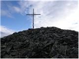
 | Plockenpass - Creta di Collinetta / Cellon
Creta di Collinetta / Cellon is a 2,238-meter-high mountain located west of the Plöcken Pass. From the summit, which features a cross, there is a...
3 h |
 | Rifugio Selvapiana I.Lunelli - Croda Sora I Colesei / Arzalpenkopf (via Forcella Popera)
Croda Sora I Colesei (German: Arzalpenkopf) is a 2,321-meter-high mountain on the eastern edge of the Sexten Dolomites (Dolomiti di Sesto). The s...
2 h 30 min |
| Rifugio Selvapiana I.Lunelli - Croda Sora I Colesei / Arzalpenkopf (via Belvedere)
Croda Sora I Colesei (German: Arzalpenkopf) is a 2,321-meter-high mountain on the eastern edge of the Sexten Dolomites (Dolomiti di Sesto). The s...
2 h 30 min |
 | Bad Kleinkirchheim - Wöllaner Nock
Wöllaner Nock is a 2145 m high peak located south of the ski area and the settlement Bad Kleinkirchheim. From the spacious summit, where a larger...
3 h 45 min |
| Bad Kleinkirchheim - Wöllaner Nock (by road)
Wöllaner Nock is a 2145 m high peak located south of the ski area and the settlement Bad Kleinkirchheim. From the spacious summit, where a larger...
4 h 15 min |
 | Bad Kleinkirchheim - Kaiseburg
Kaiseburg is a panoramic peak located directly above the Bad Kleinkirchheim ski area. From the summit, where a cross stands, a beautiful view ope...
3 h 25 min |
 | Bad Kleinkirchheim - Kaiseburg (by road)
Kaiseburg is a panoramic peak located directly above the Bad Kleinkirchheim ski area. From the summit, where a cross stands, a beautiful view ope...
3 h 55 min |
 | Malga Crocifisso - Sas de Adam
Sas de Adam (also Sass de Dama) is a 2,430-meter-high peak situated north of the alpine valley Val Sen Nicolo. From the top, a nice view opens up...
2 h 35 min |
 | Colfosco - Sas Ciampac
Sas Ciampac is a 2672-meter-high peak in the Puez group. From the summit, which features a small wooden cross, there is a nice view of the Puez g...
3 h 30 min |
 | Passo Campolongo - Setsas
The Setsas peak is located west of the Passo Valparola pass and is somewhat distant from the highest summits. Precisely because of this remotenes...
3 h 40 min |
 | Sadnighaus - Sadnig (direct way (path 150))
Sadnig or Hoher Sadnig is a relatively easily accessible and panoramic mountain in the eponymous Sadnig group (German: Sadniggruppe), the souther...
2 h 45 min |
 | Sadnighaus - Sadnig (via mountain pasture Lindler (pot 149))
Sadnig or Hoher Sadnig is a relatively easily accessible and panoramic mountain in the eponymous Sadnig group (German: Sadniggruppe), the souther...
3 h 15 min |
 | Sportgastein - Greilkopf (via Hagener Hütte)
Greilkopf is a 2,581 m high mountain in the Ankogel group of the Hohe Tauern in Austria above the town of Mallnitz. It is a popular winter destin...
3 h 45 min |
 | Parking below Jamnigalm - Feldseekopf (via Feldseecharte)
Feldseekopf, at 2,864 m, is as high as Triglav. The mountain is located in the Goldberg group of the Hohe Tauern in Austria and receives far fewe...
3 h 50 min |
 | Plöckenhaus - Polinik (path 403)
Polinik is a 2,332-meter-high mountain in the Austrian part of the Carnic Alps near the mountain pass to Italy, the Plöckenpass.East of Polinik l...
3 h 15 min |
 | Turrach - Eisenhut
Eisenhut, at 2,441 meters, is the highest peak in the Gurktal Alps, which stretch across the basin of the Krka/Gurk River and descend to the nort...
4 h 30 min |
 | Turrach - Straßburger Spitz
Straßburger Spitz is a 2,404-meter-high peak located between the summits of Eisenhut (2,441 m) and Wintertalernock (2,394 m). From the top, where...
4 h |
 | Turrach - Wintertalernock
Wintertalernock is a 2,394-meter-high peak located southeast of the highest summit of the Gurktal Alps, Eisenhut. From the top, where a cross sta...
4 h 15 min |
 | Thredbo - Mount Kosciuszko (Merritts Track & Mt. Kosciuszko Track)
Mount Kosciuszko is the highest mountain on mainland Australia, the easiest of the elite "Seven Summits", and it is also on the Ultra list. The m...
4 h |
 | Sella di Razzo - Clapsavon (via 210)
Clapsavon is a 2,462-meter-high mountain in the Carnic Alps in Italy. It lies about an hour's walk west of the 2,474-meter-high Bivera. Both peak...
3 h |
 | Lakkos tou Mygerou - Agathias (Kreta)
Agathias is the fourth-highest mountain on the island of Crete in Greece, at 2,424 meters. Agathias (Gr. Αγκαθιάς) is located southeast of Timios...
3 h |
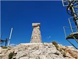
 | Nida - Timios Stavros / Psiloritis (Kreta)
Timios Stavros is Crete's highest mountain at 2,456 meters and also the highest among the Greek islands. Due to its topographic prominence, it is...
4 h 15 min |
 | Lakkos tou Mygerou - Timios Stavros / Psiloritis (Kreta)
Timios Stavros is Crete's highest mountain at 2,456 meters and also the highest among the Greek islands. Due to its topographic prominence, it is...
3 h |
 | Agion Pneuma (Avrakondes) - Spathi (Crete)
Spathi (Gr. Σπαθί) is at 2,148 m the highest mountain of the Dikti massif (Gr. Δικτή) on the Greek island of Crete. Among Crete's three massifs w...
4 h |
 | Koprivna (Kumer) - Križnik (Peca) (slovenska pot)
Križnik is a 2,109-meter-high peak on Peca, located on the Austrian side of the mountain. From the summit, just a short way above the marked path...
3 h 15 min |
| Koprein-Petzen - Križnik (Peca)
Križnik is a 2,109-meter-high peak on Peca, located on the Austrian side of the mountain. From the summit, just a short way above the marked path...
3 h |
 | Masna Luka - Pločno
Pločno is the highest peak of the Čvrsnica range and the fourth highest peak in Bosnia and Herzegovina. At its highest point is a geodetic pillar...
4 h 30 min |