 | Vidrga - Zasavska Sveta gora (on forest footpath)
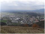
Zasavska Sveta Gora is a popular excursion destination located between Litija and Izlake. From the summit, where the parish church of the Nativit...
1 h 30 min |
| Vidrga - Zasavska Sveta gora (on a cart track)
Zasavska Sveta Gora is a popular excursion destination located between Litija and Izlake. From the summit, where the parish church of the Nativit...
1 h 30 min |
 | Mala voda - Kožljek
Kožljek is a 788 m high peak located west of Koren, more precisely above the village of Samotorica. From the summit, where there are several benc...
1 h 15 min |
 | Mala voda - Koreno
Koreno (also known as Korena) is a 729 m high hill located north of Horjul. From the summit, which features a large cross, the church of St. Moho...
1 h 15 min |
 | Spodnje Pirniče - Grmada (Kovačeva steza)
Grmada is a 676-meter-high mountain located west of the much more visited Šmarna gora. From the summit, which has a small takeoff area, a beautif...
1 h 10 min |
 | Briše - Mali vrh
West of Polhov Gradec, between the rivers Mala voda and Velika Božna, lies the 708-meter-high hill known as Mali vrh. From the grassy summit, whi...
1 h 5 min |
 | Hotovlja - Bukov vrh (by road)
Bukov vrh, where the Church of Our Lady of Sorrows stands, is located in the northwestern part of Polhograjsko hribovje. From the summit, there a...
1 h 30 min |
 | Podgorje - Kojnik (via hunting cottage)
Kojnik is a partly forested peak located in the southern part of Podgorski Kras near the Slovenian-Croatian border. From the summit, which has a ...
1 h 30 min |
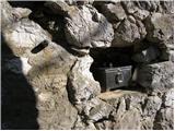
 | Liboje (quarry) - Kotečnik (via eastern ridge)
Kotečnik is a peak in the Posavsko hribovje, located north of Šmohor. It is a summit with two logboxes: the first on the western subpeak, offerin...
1 h 5 min |
 | Tržič - Kamnek (Milanova pot)
Kamnek (Kamnik on maps, also sometimes Kamnjek) is a panoramic peak above Tržič....
1 h 5 min |
 | Tržič (Slap) - Kamnek (via Dobrivc)
Kamnek (Kamnik on maps, also sometimes Kamnjek) is a panoramic peak above Tržič....
1 h |
 | End of road below Jelovec - Castle Stari grad (Čušperk Castle)
Stari Grad, or Čušperk Castle, is located south of Grosuplje, more precisely west of the village of Čušperk. Of the castle, built in the 12th cen...
1 h 30 min |
 | Podpeč - Grmada on Mala gora
Grmada (also Grmada above Ortnek) is an 887-meter-high peak located above the village of Vrh pri Poljanah in the Mala Gora range. Just a few mete...
1 h 35 min |
 | Planina - Grmada (Planinska gora)
Grmada is an 873-meter-high peak rising west of Planinsko polje. Although the summit is forested, a viewpoint just below it offers a stunning vie...
1 h |
 | Planina (Dolnja Planina) - Grmada (Planinska gora) (via Zavrtniki)
Grmada is an 873-meter-high peak rising west of Planinsko polje. Although the summit is forested, a viewpoint just below it offers a stunning vie...
1 h 5 min |
| Planina (Dolnja Planina) - Grmada (Planinska gora) (via Sv. Duh)
Grmada is an 873-meter-high peak rising west of Planinsko polje. Although the summit is forested, a viewpoint just below it offers a stunning vie...
1 h 5 min |
 | Kamnik - Visoka špica (via Krniška gora)
An indistinct but clearly visible forested hill above Kamnik from everywhere. Due to the slightly lower Čokl, on which Kamnik Castle stands, it i...
1 h |
 | Njivica - Sveti Primož in Felicijan (Jamnik)
The Church of St. Primož and Felicijan at Jamnik is located on a scenic grassy ridge rising between Kropa and Podblica. From the church or its ne...
1 h 10 min |
 | Brezovica - Sveti Primož in Felicijan (Jamnik)
The Church of St. Primož and Felicijan at Jamnik is located on a scenic grassy ridge rising between Kropa and Podblica. From the church or its ne...
1 h 20 min |
| Češnjica pri Kropi - Sveti Primož in Felicijan (Jamnik) (via Berigla)
The Church of St. Primož and Felicijan at Jamnik is located on a scenic grassy ridge rising between Kropa and Podblica. From the church or its ne...
1 h 20 min |
| Kropa (Slovenska peč) - Sveti Primož in Felicijan (Jamnik)
The Church of St. Primož and Felicijan at Jamnik is located on a scenic grassy ridge rising between Kropa and Podblica. From the church or its ne...
1 h 10 min |
 | Rodik - Sveti Socerb (Artviže)
The Church of St. Socerb is located on a panoramic hill above the village of Artviže, which at 817 meters is the highest peak of the Brkini. From...
1 h 20 min |
 | Trojane - Lipovec
Lipovec is an 848-meter-high peak located above the pastures of Lipovec. On clear days, the summit offers views of the Posavsko hribovje, Kum, Me...
1 h 30 min |
 | Jasen - Ahac
Ahac (or Sv. Ahac) is a 799-meter-high peak located east of Ilirska Bistrica. The summit hosts a summit logbox, a cross, and ruins of the former ...
1 h |
| Vrbovo - Ahac
Ahac (or Sv. Ahac) is a 799-meter-high peak located east of Ilirska Bistrica. The summit hosts a summit logbox, a cross, and ruins of the former ...
1 h |
 | Šembije - Gradišče (Čepan)
Gradišče (also Čepan) is a 791-meter-high peak in the ridge between Šembije and Pivka. At 791 meters, it marks the highest point of the Brkini ed...
1 h 20 min |
 | Puščava - Lobnikov vrh
Lobnikov vrh is a forested peak above the Dravska dolina valley, located between the settlements of Fala and Ruta. From the east, due to its remo...
1 h 20 min |
| Činžat - Lobnikov vrh
Lobnikov vrh is a forested peak above the Dravska dolina valley, located between the settlements of Fala and Ruta. From the east, due to its remo...
1 h |
 | Log - Pečke (by road)
Pečke is an easily accessible peak that has seen fewer visitors lately, located north of the main Pohorje ridge. It gets more visits only on May ...
1 h 5 min |
 | Babni Vrt - Gradišče (Pustinjak) (through the forest and past sv. Lovrenc)
Gradišče or Pustinjak (also Gradišče nad Bašljem) is an 871-meter-high peak located above the Belica stream, which lies below the 2,132-meter-hig...
1 h 25 min |
 | Logatec (Gorenja vas) - Šenčurjev vrh (via Žibrše)
Šenčurjev vrh is a 725-meter-high hill located above the settlement of Žibrše, which lies between Logatec, Hotedršica, and Rovte. At the summit, ...
1 h 30 min |
 | Adergas - Apnišče (via Šterna)
Apnišče is a 740 m high mountain between Možjanca and Štefanja gora. It is the highest point of the Šenčur municipality. The forested summit offe...
1 h |
 | Preddvor - Apnišče (on footpath)
Apnišče is a 740 m high mountain between Možjanca and Štefanja gora. It is the highest point of the Šenčur municipality. The forested summit offe...
1 h 15 min |
 | Blejska Dobrava (cemetery) - Hom at Bled (via Katarina)
Hom is an 834-meter-high hill rising north above the villages of Zasip and Podhom near Bled, or south of the village Blejska Dobrava near Jesenic...
1 h 25 min |
 | Blejska Dobrava (cemetery) - Hom at Bled (on east slope)
Hom is an 834-meter-high hill rising north above the villages of Zasip and Podhom near Bled, or south of the village Blejska Dobrava near Jesenic...
1 h 5 min |
 | Dvor - Kucelj above Polhov Gradec (on marked path)
Kucelj is a somewhat less known peak located between Polhov Gradec and Dvor pri Polhovem Gradcu. From the 705-meter-high summit, a view opens tow...
1 h |
| Dvor - Kucelj above Polhov Gradec (on unmarked path)
Kucelj is a somewhat less known peak located between Polhov Gradec and Dvor pri Polhovem Gradcu. From the 705-meter-high summit, a view opens tow...
1 h |
| Polhov Gradec - Kucelj above Polhov Gradec (via Ravnek)
Kucelj is a somewhat less known peak located between Polhov Gradec and Dvor pri Polhovem Gradcu. From the 705-meter-high summit, a view opens tow...
1 h |
 | Mežica - Andrejev vrh (by cart track)
Andrejev vrh is a forest-covered peak located between Mežica and Leše. On the summit there is a bench and a summit register box with a logbook....
1 h 15 min |
| Mežica - Andrejev vrh (past the chapel)
Andrejev vrh is a forest-covered peak located between Mežica and Leše. On the summit there is a bench and a summit register box with a logbook....
1 h 20 min |
| Leše - Andrejev vrh (via Leše churches and via chapel)
Andrejev vrh is a forest-covered peak located between Mežica and Leše. On the summit there is a bench and a summit register box with a logbook....
1 h 35 min |
| Leše - Andrejev vrh (past Leše churches and on cart track)
Andrejev vrh is a forest-covered peak located between Mežica and Leše. On the summit there is a bench and a summit register box with a logbook....
1 h 30 min |
 | Prevalje - Brinjeva gora (above Prevalje) (via Stations of the Cross)
Brinjeva gora is a popular excursion spot for Prevalje locals, located between the Meža River and Zelenbreški Stream. On the summit stands a smal...
1 h |
| Prevalje - Brinjeva gora (above Prevalje) (south path)
Brinjeva gora is a popular excursion spot for Prevalje locals, located between the Meža River and Zelenbreški Stream. On the summit stands a smal...
1 h |
| Ravne na Koroškem - Brinjeva gora (above Prevalje)
Brinjeva gora is a popular excursion spot for Prevalje locals, located between the Meža River and Zelenbreški Stream. On the summit stands a smal...
1 h 10 min |
 | Rudnik pri Radomljah - Tolsta gora
Tolsta gora is a 734-meter-high mountain located above the settlement of Vrhpolje pri Kamniku. From the summit, where a cairn stands, there is no...
1 h 25 min |
 | Rudnik pri Radomljah - Vrtače (via Lancar)
Vrtače is a 758-meter-high peak located above the village of Zgornje Palovče. The summit is overgrown with forest, but from a clearing slightly b...
1 h 30 min |
 | Škofja Loka - Vrh soteske (Križna gora)
Vrh soteske is a 735 meters high peak, which is situated on the southwestern part of Križna gora. From the top, which is overgrown by the forest,...
1 h 25 min |
| Vešter - Vrh soteske (Križna gora)
Vrh soteske is a 735 meters high peak, which is situated on the southwestern part of Križna gora. From the top, which is overgrown by the forest,...
1 h 15 min |
 | Graz Center West - Buchkogel (Rudolfswarte) (via St. Martin)
Buchkogel, also known as Graz Buchkogel, is located west of Graz and, alongside Plabutsch, is one of the most popular excursion destinations on t...
1 h 30 min |
 | Hotavlje - Vrh Slajke
Vrh Slajke is a 790-metre hill above Hotavlje, specifically above the right bank of the Kopačnica. From the summit, where an antenna tower stands...
1 h 15 min |
| Hotavlje - Vrh Slajke (via Bela)
Vrh Slajke is a 790-metre hill above Hotavlje, specifically above the right bank of the Kopačnica. From the summit, where an antenna tower stands...
1 h 30 min |
| Podgora - Vrh Slajke
Vrh Slajke is a 790-metre hill above Hotavlje, specifically above the right bank of the Kopačnica. From the summit, where an antenna tower stands...
1 h 25 min |
 | Selca - Lepo brdo
Lepo brdo is a 778-metre hill rising above the Selca and Studeno settlements....
1 h |
 | Sora - Breznik (Boben)
Breznik, also known as Boben, is a 643-meter-high peak situated above the right bank of the Ločnica, more precisely above Sora, Rakovnik, Goričan...
1 h 5 min |
 | Lovrenc na Pohorju (cemetery) - Koglerjev vrh (via Hožičev vrh)
Koglerjev vrh is a 698-meter-high forested peak located southwest of the organic farm Šlaus-Kogler, which lies above the settlement of Lovrenc na...
1 h |
 | Stari Grad (Šega) - Dedni vrh (Šuštarica)
Dedni vrh, also known as Šuštarica, is a lesser-known peak in the Karawanks located north of Plešivec. The summit lies in the forest and offers l...
1 h |
 | Zreče (Terme Zreče) - Golek (steep path)
Golek is a 769-meter-high peak located northwest of Zreče. The summit has a logbook box with book and stamp, plus a bench; a short distance (a fe...
1 h 20 min |