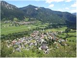
 | Topol - Sveti Jakob
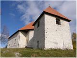
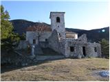
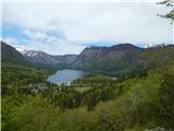
The Church of St. James is located on a scenic hill north of the village of Topol pri Medvodah. From the summit, which features a registration bo...
40 min |
| Topol - Sveti Jakob (via homestead Na Vihri)
The Church of St. James is located on a scenic hill north of the village of Topol pri Medvodah. From the summit, which features a registration bo...
45 min |
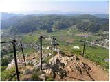
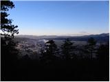
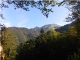
 | Javornik - Sveti Jošt above Kranj
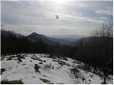
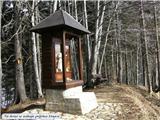
Sveti Jošt above Kranj is a hill located west of the slightly lower Šmarjetna gora. From the summit, where the Church of St Jošt stands alongside...
40 min |
| Čepulje - Sveti Jošt above Kranj
Sveti Jošt above Kranj is a hill located west of the slightly lower Šmarjetna gora. From the summit, where the Church of St Jošt stands alongside...
45 min |
 | Topol - Jeterbenk
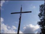
Jeterbenk is a 774-meter-high peak located between the Slavkov dom hut on Golo Brdo and Katarina (the village of Topol). From the summit, where t...
45 min |
 | Križna Gora - Archangel Gabriel (Planica)
Planica is an 824-meter-high peak located north of Škofja Loka, more precisely between Križna gora and Planica. From the summit, where the church...
35 min |
 | Veliki Ločnik - Sveti Ahac
The Church of St. Ahac is located on the summit named Gora above the villages of Mali and Veliki Ločnik near Turjak. From the top, which has a lo...
30 min |
 | Lanišče - Janče
Janče is a 792-meter-high peak situated between the Sava River and the Besnica stream valley. From the summit, where a mountain hut stands and th...
30 min |
 | Zabukovica (Podvine) - Dom na Bukovici
The mountain hut Dom na Bukovici is situated just a few meters below the summit of the forested Bukovica. From the hut, near which there is a lar...
25 min |
 | Sveta Gora - Vodice
Vodice (according to some records also Sveti Jakob) is a peak on the western part of the Banjška planota plateau. From the summit, which features...
45 min |
 | Železna vrata - Trstelj
Trstelj is the highest peak in the ridge of Črni hribi. From the spacious summit, which has TV transmitters, the view is divided. From the north ...
35 min |
 | Tržič - Sveti Jurij above Tržič
The Church of St. Jurij, built in the 15th century, stands on a small hill above Tržič or Bistrica pri Tržiču. Nearby Gutenberg Castle, to which ...
40 min |
 | Grozzana / Gročana - Kokoš
The Koča na Kokoši mountain hut is located on Jirmanec peak, just 5 minutes from the forested Kokoš. From the summit, situated south of Lokavsko ...
40 min |
 | Blečji vrh - Kucelj
Kucelj is a 748-meter-high peak situated north of Višnja gora. From the summit, where there is a small geodetic tower with a nearby stamp, there ...
45 min |
| Veliko Trebeljevo - Kucelj
Kucelj is a 748-meter-high peak situated north of Višnja gora. From the summit, where there is a small geodetic tower with a nearby stamp, there ...
45 min |
 | Lokev - Stari tabor
Stari Tabor is a panoramic peak located west of Divača, north of Lokev, and south of the village of Povir. From the summit, which has a stamp and...
45 min |
| Vilenica - Stari tabor
Stari Tabor is a panoramic peak located west of Divača, north of Lokev, and south of the village of Povir. From the summit, which has a stamp and...
45 min |
 | Sveta Trojica - Murovica
Murovica is a popular excursion point, accessible from the Posavje side, Domžale, or the Moravška Valley. On the summit there is a bench and a lo...
45 min |
 | Zgornja Javoršica - Murovica
Murovica is a popular excursion point, accessible from the Posavje side, Domžale, or the Moravška Valley. On the summit there is a bench and a lo...
25 min |
| Križevska vas - Murovica
Murovica is a popular excursion point, accessible from the Posavje side, Domžale, or the Moravška Valley. On the summit there is a bench and a lo...
45 min |
 | Vitovlje - Vitovski hrib (by road)
Vitovski hrib is a 604-meter-high hill located north of the village Vitovlje in the Vipava Valley. From the summit, where there is a church dedic...
30 min |
 | Jesenice (Ukova) - Kalvarija above Jesenice
Kalvarija is a popular point or peak above the town of Jesenice, known either as a sort of short "pilgrimage" path for the faithful or as a desti...
25 min |
 | Velika Zaka (Bled) - Mala Osojnica (along Ojstrica)
Mala Osojnica is a 691-meter-high peak rising above Lake Bled near Velika Zaka. It is considered the most popular spot for photographers, as all ...
40 min |
 | Mislinja - Črepič
Črepič is an 798-meter-high peak west of Mislinja. The summit is forested and offers no view, but there is an expansive panorama from a nearby me...
45 min |
 | Begunje - Goli vrh (Cemarovnik)
Goli vrh, also known as Begunjski Cemarovnik, is an 816 m high mountain located on the southeastern part of Menišija. From the summit, where a la...
30 min |
 | Belo - Goljek
Goljek is an 809 m high peak located east of Polhograjska Grmada. From the summit, where remains of a former guard tower on the Italian-German bo...
40 min |
| Topol - Goljek (on west ridge)
Goljek is an 809 m high peak located east of Polhograjska Grmada. From the summit, where remains of a former guard tower on the Italian-German bo...
30 min |
 | Trebež (Jesenice) - Kozjek (on east ridge)
Kozjek is a 766 m high, easily accessible ridge-like secondary peak of Jelenkamen, belonging to the southern Karawanks foothills; it is located a...
30 min |
 | Čepulje - Špičasti hrib
Špičasti hrib (known as Špičasti vrh on maps) is an 837-meter-high hill located west of Sveti Jošt above Kranj. The summit, which has a few bench...
40 min |
 | Vinska Gora - Gonžarjeva peč (easy path)
Gonžarjeva peč, increasingly known in recent times due to a new climbing route, is located on a hill northwest of Vinska Gora. At the summit of G...
30 min |
 | Hunting sports association Vinska Gora - Temnjak
Temnjak (on some maps also written as Vinska gora, the neighboring hill) is a 798 m high peak located north of the village of Prelska pri Vinski ...
25 min |
 | Hunting sports association Vinska Gora - Vinska gora
Vinska gora (marked as the neighboring Temnjak on some maps) is an 806 m high hill located northwest of Dobrna and northeast of Vinska Gora. From...
40 min |
 | Srednje - Globočak
Globočak is an 809 m high peak located in the Kanal Kolovrat range. From the summit, which has some remnants from the First World War, there is n...
35 min |
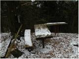
 | Mojstrana - Grančišče (south path)
Grančišče (also Grančiše) is a small precipitous hill rising west to southwest of Mojstrana. From the summit, where there is a bench and table, a...
25 min |
 | Pivka - Primož
Primož is a 718-meter-high peak located south to southeast of Pivka. Due to its ideal location overlooking the entire Pivka Basin, the Italians b...
25 min |
 | Zagorje - Šilentabor
Šilentabor is a 751-meter-high peak just above the village of the same name. From the summit, near which there is a bench and a logbook box, ther...
35 min |
 | Črne njive - Ahac
Ahac (or Sv. Ahac) is a 799-meter-high peak located east of Ilirska Bistrica. The summit hosts a summit logbox, a cross, and ruins of the former ...
40 min |
 | Gaber pri Semiču - Semenič
Semenič is a 590-meter-high, forest-covered peak located southwest of the better-known Smuk above Semič. A castle from the 12th century once stoo...
30 min |
 | Žusem Castle - Žusem
Žusem is a 669-meter-high hill with a rich history and great potential for the future. It forms the northern edge of Kozjansko, and its name deri...
30 min |
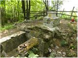
 | Potoče - Novi grad (Pusti grad)
Novi grad or Pusti grad (German: Neuburg) is first mentioned in 1156. Today, only ruins remain of the castle, which is located on a hill north to...
25 min |
| Preddvor - Novi grad (Pusti grad)
Novi grad or Pusti grad (German: Neuburg) is first mentioned in 1156. Today, only ruins remain of the castle, which is located on a hill north to...
40 min |
 | Dobrič (Vedet) - Brezovec
Brezovec is a 617-meter-high peak located north of Gora Oljka. The summit features a logbook box with book and stamp, but due to the surrounding ...
25 min |
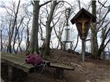
 | Veliko Trebeljevo - Sveta Marjeta (Prežganje)
The Church of St. Marjeta stands on the hilltop above Prežganje. Next to the church is the Minorite retreat house, and a bit lower down the Marje...
40 min |
 | Travnarjev gozd (Hotenjsko podolje) - Sveta Barbara (Ravnik pri Hotedršici)
The Church of St. Barbara is located on a panoramic rise above the settlement of Ravnik pri Hotedršici. From the church or its immediate surround...
35 min |
 | Možjanca - Apnišče
Apnišče is a 740 m high mountain between Možjanca and Štefanja gora. It is the highest point of the Šenčur municipality. The forested summit offe...
35 min |
 | Čatež - Bajturn (Zaplaški hrib) (on ridge)
Bajturn, or Zaplaški hrib, at 609 meters, is the highest peak in the Trebnje municipality. The summit features a pleasant bench with a table, a b...
40 min |
 | Kamna Gorica - Lipnica Castle (Pusti grad above Lipnica)
Lipniški Castle, or Pusti grad above Lipnica (German: Waldenberg), is located on a panoramic hill above the Sava and Lipnica watercourses, more p...
40 min |
| Kamna Gorica - Lipnica Castle (Pusti grad above Lipnica) (via Galerije)
Lipniški Castle, or Pusti grad above Lipnica (German: Waldenberg), is located on a panoramic hill above the Sava and Lipnica watercourses, more p...
45 min |
 | Jezersko polje - Peč (viewpoint)
The viewpoint is located about 50 vertical meters below the 720-meter-high Peč peak, which separates the Lower from the Upper Bohinj Valley on th...
35 min |
 | Pečar - Žagarski vrh
Žagarski vrh is situated on the ridge between Podlipoglav and Besnica. From the summit, where there is the amateur radio operators' hut, there is...
35 min |
 | Aussichtswarte Vulkanland - Stradner Kogel
Stradner Kogel is the highest hill in southeastern Styria, Austria. The hill is of volcanic origin, and the summit offers no views in any directi...
45 min |
 | Škalske Cirkovce - Skalni vrh (Vodemla)
Skalni vrh is the highest summit of the hill Vodemla, which rises on one side above Paka pri Velenju and on the other above the Velenje Basin. Al...
35 min |
 | Žiri - Goropeški grič (Pikrej)
Goropeški grič, also known as Pikrej, is located south of Žiri. From the meadows near the logbook box, a nice view opens up onto the surrounding ...
30 min |
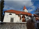
 | Gorenja Dobrava - Sveti Urban (above Gorenja Dobrava)
The Church of St. Urban is located on a hill between Gorenja Dobrava and Todraž. From the summit, where there is a summit register box with a log...
25 min |
 | Škalske Cirkovce - Lubela (by road)
Lubela is a hill near Velenje that rises to the north above the Šaleška Valley and belongs to the Šentviško Hills or the broader Graška Gora area...
45 min |
 | Zajasovnik - del (Strmce, chapel) - Jasovnik (Motnik tourist trail)
Jasovnik is a hill better known to everyone as the A1 highway tunnel. It lies near Trojane and has two peaks: Mali Jasovnik and Jasovnik. The sum...
45 min |
 | Lovrenc na Pohorju (cemetery) - Hožičev vrh
Hožičev vrh is a 595-meter-high indistinct peak located southwest of the center of Lovrenc na Pohorju. At the summit, there is a small sign marki...
40 min |
 | Planina pri Sevnici - Sveti Križ (above Planina pri Sevnici) (via Pravljični gozd)
The Church of the Holy Cross is located above Planina pri Sevnici, near the settlement of Šentvid pri Planini. From the summit opens a fine view ...
28 min |
 | Zreče (church of St. Egidij) - Sveti Martin (Zlakova) (on PP4)
The Church of St. Martin is situated on a panoramic hill on the edge of Zlakova village. From the church, a nice view opens up towards part of Po...
40 min |
 | Smiljan - Krčmar (on marked path)
Krčmar is a 773-meter-high peak above Smiljan, known for the Nikola Tesla Memorial Center. There is a cross and an HPO stamp on the summit, which...
40 min |
 | Road on Bjelsko - Stožac
Stožac is a distinct peak situated south of the more famous Klek, above Ogulin. There is no marked trail to the summit itself. Just below the top...
30 min |
 | Rašpor - Gradina Rašpor (on marked path)
Gradina Rašpor are the ruins of a former castle above the village of Rašpor. Several information boards are by the ruins. Due to the surrounding ...
45 min |