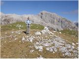
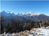
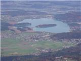
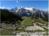
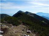
 | Planina Jezerca - Veliki Zvoh (on unmarked path via Razor)
Veliki Zvoh is the highest point of the Krvavec ski resort. The cable car does not quite reach the summit but stops only a few metres short. A fe...
2 h 15 min |
 | End of road on Pokljuka - Viševnik (via Gola Ravan)
Viševnik is a 2050 m high mountain rising northwest of Rudno polje on Pokljuka. From the summit, where there is a stamp, a beautiful view opens o...
2 h 15 min |
| Rudno polje - Viševnik (via Gola Ravan)
Viševnik is a 2050 m high mountain rising northwest of Rudno polje on Pokljuka. From the summit, where there is a stamp, a beautiful view opens o...
2 h 15 min |
 | End of road on Pokljuka - Viševnik (via source of Zlata voda)
Viševnik is a 2050 m high mountain rising northwest of Rudno polje on Pokljuka. From the summit, where there is a stamp, a beautiful view opens o...
2 h 20 min |
| Rudno polje - Viševnik (via source of Zlata voda)
Viševnik is a 2050 m high mountain rising northwest of Rudno polje on Pokljuka. From the summit, where there is a stamp, a beautiful view opens o...
2 h 20 min |
| Uskovnica (Razpotje) - Viševnik (via source of Zlata voda)
Viševnik is a 2050 m high mountain rising northwest of Rudno polje on Pokljuka. From the summit, where there is a stamp, a beautiful view opens o...
2 h 55 min |
| Uskovnica (Razpotje) - Viševnik (via Gola Ravan)
Viševnik is a 2050 m high mountain rising northwest of Rudno polje on Pokljuka. From the summit, where there is a stamp, a beautiful view opens o...
2 h 50 min |
 | Gozd - Tolsti vrh (Sheep Trail across Kriška Gora)
Tolsti vrh, located west of Storžič, is at 1715 metres also the highest peak of the Kriška gora range, which rises steeply above central Gorenjsk...
2 h 30 min |
 | Tržiški graben - Veliki Javornik (Ženiklovec)
Veliki Javornik (also known as Ženiklovec) is a 1716 m high peak located between Storžič and Stegovnik. From the grassy summit with its registrat...
2 h 30 min |
 | Križovec - Barentaler Kotschna/Struška (čez Sedlo Kočna)
Struška is a smaller mountain range in the Karavanke ridge, located between Stol (specifically Belščica) and Golica. From Veliki vrh (1944 m), th...
2 h 30 min |
| Križovec - Barentaler Kotschna/Struška (by road)
Struška is a smaller mountain range in the Karavanke ridge, located between Stol (specifically Belščica) and Golica. From Veliki vrh (1944 m), th...
2 h 15 min |
 | Planina pod Golico - Kahlkogel/Golica (via Ovčarska koča - eastern way)
Golica is an unvegetated peak located north of Jesenice. From the summit, where a registration box is placed, there is a fine view of the western...
2 h 50 min |
 | Dom Pristava in Javorniški Rovt - Kahlkogel/Golica (on the ridge)
Golica is an unvegetated peak located north of Jesenice. From the summit, where a registration box is placed, there is a fine view of the western...
2 h 50 min |
 | Erjavčev rovt - Frauenkogel/Dovška Baba (direct way)
Dovška Baba is a 1891-meter-high peak located on the border ridge between Slovenia and Austria. From the summit, which has a registration box and...
2 h 15 min |
 | Rogarjev rovt - Frauenkogel/Dovška Baba (via Rožca and Hruški vrh)
Dovška Baba is a 1891-meter-high peak located on the border ridge between Slovenia and Austria. From the summit, which has a registration box and...
2 h 30 min |
 | End of road on Vogar - Slatna (via Griva)
Slatna is a panoramic mountain located between Kreda and Prvi Vogel. From its grassy summit, which is not reached by any marked path, a fine view...
3 h 50 min |
 | Smrečje - Pečovnik (survey point 1668) (by road)
Pečovnik (1668 m) is a 1668-meter-high mountain located between Plešivec (1801 m) and Virnikov Grintovec (1654 m). From its grassy summit on the ...
2 h 45 min |
 | Jezerski vrh - Pečovnik (survey point 1668)
Pečovnik (1668 m) is a 1668-meter-high mountain located between Plešivec (1801 m) and Virnikov Grintovec (1654 m). From its grassy summit on the ...
2 h 45 min |
 | Jezerski vrh - Plešivec
Plešivec is an 1801 m high peak situated south of the eastern part of Košuta. From the summit, where a border marker stands, there is a beautiful...
3 h 30 min |
 | Rateče - Ofen/Peč (western path, past bivouac and on footpath)
Peč (also known as Tromeja; in Italian Monte Forno, in German Dreiländereck or Ofen) is a 1508 m high peak located at the tripoint between Sloven...
2 h 15 min |
| Rateče - Ofen/Peč (western path, past bivouac and on mule track)
Peč (also known as Tromeja; in Italian Monte Forno, in German Dreiländereck or Ofen) is a 1508 m high peak located at the tripoint between Sloven...
2 h 20 min |
 | Polja - Ofen/Peč (via Petelinjek)
Peč (also known as Tromeja; in Italian Monte Forno, in German Dreiländereck or Ofen) is a 1508 m high peak located at the tripoint between Sloven...
2 h 45 min |
| Polja - Ofen/Peč (via Kališje)
Peč (also known as Tromeja; in Italian Monte Forno, in German Dreiländereck or Ofen) is a 1508 m high peak located at the tripoint between Sloven...
2 h 15 min |
 | Javorje - Rodica (via Lepa Suha)
The mountain Rodica is located above Bohinj in the Lower Bohinj Mountains. From the summit there is a beautiful view over the Julian Alps and the...
2 h 30 min |
 | Rudno polje - Debeli vrh above Lipanca (via Zgornji Razor)
Debeli vrh is a 1962 m high mountain located in the ridge that rises steeply above the Krma valley. From the summit, where a stamp is attached to...
2 h 15 min |
 | Ravne - Rosenkogel/Hruški vrh (via Dovška Baba)
Hruški vrh is a 1776-metre-high mountain located between Dovška Baba and the lesser-known Klek. From the summit, where there is a small chapel de...
2 h 25 min |
 | Ravne - Klek (via Hruški vrh)
Klek is a 1753-metre-high mountain located between Hruški vrh and the better-known Golica. The summit, on the border between Slovenia and Austria...
2 h 30 min |
| Planina pod Golico - Klek (via Rožca)
Klek is a 1753-metre-high mountain located between Hruški vrh and the better-known Golica. The summit, on the border between Slovenia and Austria...
2 h 20 min |
 | Planina pod Golico - Klek (via Ovčarska koča)
Klek is a 1753-metre-high mountain located between Hruški vrh and the better-known Golica. The summit, on the border between Slovenia and Austria...
3 h |
 | Srednji Vrh - Vošca (via Zajčnik)
Vošca is a 1737 m high peak located west of Trupejevo poldne. From the grassy summit, there is a beautiful view of the Julian Alps, western Karaw...
2 h 35 min |
 | Srnjak - Vošca
Vošca is a 1737 m high peak located west of Trupejevo poldne. From the grassy summit, there is a beautiful view of the Julian Alps, western Karaw...
2 h 45 min |
 | Gate (Belca) - Kresišče (by road)
Kresišče is an 1839 m high peak in the main ridge of the Karawanks, specifically between Kepa and Trupejevo poldne. From the summit, where a wood...
3 h |
 | Srednji Vrh - Kresišče (via Grajšca)
Kresišče is an 1839 m high peak in the main ridge of the Karawanks, specifically between Kepa and Trupejevo poldne. From the summit, where a wood...
2 h 50 min |
177100.th.jpg) | Gate (Belca) - Mojstrovica
Mojstrovica is a panoramic grassy peak in the western part of the Karawanks, located between the Belca Valley and the Hladnik stream valley. From...
2 h 20 min |
438900.th.jpg) | Gate (Belca) - Visoki vrh (by road)
Visoki vrh (also known as Visoki Kurji vrh) is an 1828 m high mountain located west of the Belca River valley. From the summit, marked by a small...
2 h 55 min |
 | Gate (Belca) - Visoki vrh (via Bašinov breg)
Visoki vrh (also known as Visoki Kurji vrh) is an 1828 m high mountain located west of the Belca River valley. From the summit, marked by a small...
2 h 40 min |
 | Urbas - Weinasch/Vajnež
Vajnež is the highest peak of Belščica, a subrange located west of the better-known Stol. The summit features a cross and both Slovenian and Aust...
2 h 25 min |
| Olipova planina - Weinasch/Vajnež (via Hrašenska planina)
Vajnež is the highest peak of Belščica, a subrange located west of the better-known Stol. The summit features a cross and both Slovenian and Aust...
2 h 50 min |
 | Ravne - Jerebikovec
The panoramic, slightly overgrown peak is located above Mojstrana and Radovna. From the summit, there is a beautiful view towards the Karawanks a...
2 h 45 min |
| Planina Spodnji Kozjek - Jerebikovec
The panoramic, slightly overgrown peak is located above Mojstrana and Radovna. From the summit, there is a beautiful view towards the Karawanks a...
2 h 30 min |
 | Javorje - Šija (via Kratki plaz)
Šija is located above the Vogel ski resort in the Lower Bohinj Mountains. From the summit, there is a nice view of the neighboring peaks in the s...
2 h 40 min |
 | Gate (Belca) - Mallestiger Mittagskogel (by road)
Ostra peč, known in German as Mallestiger Mittagskogel, is an 1801 m high mountain located on the northern side of the main Karawanks ridge. From...
3 h 25 min |
 | Srednji vrh - Mallestiger Mittagskogel (Via Grajšca)
Ostra peč, known in German as Mallestiger Mittagskogel, is an 1801 m high mountain located on the northern side of the main Karawanks ridge. From...
3 h 10 min |
 | Urbas - Potoški Stol
Potoški Stol is located between Stol and Vajnež on the border with Austria. A cross stands just a few metres below the grassy summit. The finest ...
2 h 15 min |
| Olipova planina - Potoški Stol
Potoški Stol is located between Stol and Vajnež on the border with Austria. A cross stands just a few metres below the grassy summit. The finest ...
2 h 40 min |
 | Dom na Smrekovcu - Komen (via Smrekovec and Krnes)
At 1684 meters, Komen is the highest peak in the Smrekovec mountain range, which borders between Styria and Carinthia. In good weather, the summi...
2 h 15 min |
 | Valley of stream Žep - Komen
At 1684 meters, Komen is the highest peak in the Smrekovec mountain range, which borders between Styria and Carinthia. In good weather, the summi...
2 h 30 min |
 | Valley of stream Žep - Veliki Travnik (Turnovka) (via partisan hospital)
Veliki Travnik, also known as Turnovka by the locals, is located on the western edge of the Smrekovec mountain range. From the summit, which has ...
2 h 25 min |
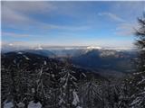
 | Mislinjski graben (Pestotnik) - Rogla (via Ostruščica)
Rogla is a peak in the middle of the eponymous ski resort. The peak is forested with a small clearing on which stands a lookout tower. The tower ...
3 h |
 | Smrečje - Pečovnik (by road)
Pečovnik is a 1640-meter-high peak situated in the ridge of mountains between Košuta and Virnikov Grintovec. From the partly vegetated peak, a ni...
2 h 35 min |
 | Jezerski vrh - Pečovnik
Pečovnik is a 1640-meter-high peak situated in the ridge of mountains between Košuta and Virnikov Grintovec. From the partly vegetated peak, a ni...
2 h 35 min |
 | Jevšček - Monte Mataiur/Matajur
Matajur is a panoramic mountain located on the border between Slovenia and Italy. From the summit there is a beautiful view of Kobariški or Bregi...
2 h 30 min |
 | NC Planica - Glave (by ski jumping hill)
Glave is an indistinct side ridge of Ponca, rising steeply west of Planica. Maps incorrectly label its highest peak (1,760 m) as Ovčja stran; tha...
2 h 30 min |
| Rateče (Ledine) - Glave
Glave is an indistinct side ridge of Ponca, rising steeply west of Planica. Maps incorrectly label its highest peak (1,760 m) as Ovčja stran; tha...
2 h 50 min |
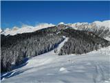
 | Markova raven - Krvavec (on unmarked path via Razor)
Krvavec is a 1,853-meter-high peak located in the heart of the eponymous ski resort. From the summit, which is crisscrossed with cable cars, ther...
2 h 45 min |
 | Ravne - Kleiner Frauenkogel/Koprivnjak
Koprivnjak (Mala Dovška Baba) is a 1754 m high peak on the Austrian side of the Karawanks. From the summit, where a cross and summit logbook stan...
2 h 20 min |
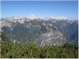
 | Koprivna (Kumer) - Velika glava (Peca) (via Knipsovo sedlo)
Velika glava is a peak in the Peca range, located between Kordeževa glava and Končnikov vrh. From the summit, which borders Austria, a beautiful ...
3 h 10 min |
 | Mangartska planina - Šober / Monte Sciober Grande (via Dren)
Šober / Monte Sciober Grande is a 1,845 m high peak located between the Remšendol Valley and Jezerska Valley. From the summit there is a fine vie...
2 h 35 min |
 | Spodnje Danje - Altemaver (Ratitovec)
Altemaver (Ratitovec), at 1,678 meters, is the highest peak of Ratitovec. From its grassy summit, there is a beautiful view of the Julian Alps, J...
2 h 30 min |
 | Srednji Vrh - Maloško poldne / Mallestiger Mittagskogel
Maloško poldne, or Mallestiger Mittagskogel in German, is a 1,823-meter-high peak on the border between Slovenia and Austria, precisely between T...
2 h 55 min |
 | Gate (Belca) - Maloško poldne / Mallestiger Mittagskogel (by road)
Maloško poldne, or Mallestiger Mittagskogel in German, is a 1,823-meter-high peak on the border between Slovenia and Austria, precisely between T...
3 h 10 min |
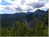
 | Vas na Skali - Čisti vrh
Čisti vrh is a 1875 m high mountain located north of the Špičje ridge, more precisely on a panoramic elevation above the Čez Drt saddle. From the...
3 h 30 min |
 | Planina Blato - Krsteniški Stog (čez Krsteniški preval)
Krsteniški Stog, or Mali Stog, is a 1879 m high mountain rising steeply above the Krstenica mountain pasture. From the summit, where a stone cair...
2 h 25 min |
 | Srednji Vrh - Zajčnik
Zajčnik (also Blekova) is a 1746-meter-high peak situated northeast of Vošca. From the partly vegetated summit, which borders Slovenia and Austri...
2 h 10 min |
 | Vrh Bače - Rušni vrh
Rušni vrh is a 1,786-meter-high peak located east of Črna Prst. From the summit, which features a border stone from the old Rapallo border, a bea...
3 h |
 | Spodnje Danje - Kremant (Ratitovec)
Kremant is a 1,654 m high peak located on the western part of Ratitovec. From the summit, where a stamp is attached to a metal pole, a nice view ...
2 h 30 min |
 | Kosmačev preval - Lengarjeva glava
Lengarjeva glava is a 1,498 m high peak situated between the Vrata and Kot valleys. From the partly vegetated summit, a nice view opens up on Deb...
3 h 30 min |
 | Srnjak - Tamarča
Tamarča is a lesser-known peak located northwest of Vošca. From its summit, surrounded by larch forest, a nice view opens up onto the Martuljek m...
2 h 30 min |
 | Carbonin - Knollkopf / Col Rotondo dei Canope
The 2204 m high Knollkopf / Col Rotondo dei Canope is located in Fanes-Sennes-Prags Nature Park. Mostly covered in dwarf pines, it features a cro...
3 h |
 | Vodel - Hunting cottage Na Glinu
The hunting cottage Na Glinu is situated on a panoramic hill between the mountain pastures Suha and Poljana. From the cottage there opens a nice ...
2 h 35 min |
 | Šajda / Schaidasattel - Kravji vrh / Kuhberg (via Obirsko sedlo)
Kravji vrh / Kuhberg is a two-thousander on the Obir with two approximately equally high peaks. Apart from dwarf pines, there is nothing on the h...
2 h 45 min |
 | Šajda / Schaidasattel - Kravji vrh / Kuhberg (steep path)
Kravji vrh / Kuhberg is a two-thousander on the Obir with two approximately equally high peaks. Apart from dwarf pines, there is nothing on the h...
2 h 30 min |
 | Javorje - Gradovec (path over Glin)
Gradovec is a 1,692-meter-high peak located north of the ridge of Spodnje Bohinjske gore, specifically above the mountain pasture Poljana. From t...
3 h 10 min |
 | Mislinjski graben (Pestotnik) - Ostruščica
Ostruščica is a 1,498-meter-high peak located west of the ski slopes on Rogla....
2 h 30 min |
 | Trbiž / Tarviso - Florjanka / Monte Florianca (on transport road)
Florjanka is a 1,653-meter-high mountain on the Italian side of the Julian Alps. At or just below the summit is a reservoir for snowmaking on the...
2 h 30 min |
 | Concentration camp - Hajnžev Praprotnik / Zeller Prapotnik
Hajnžev Praprotnik is a 1,727-metre peak on the Austrian side of the Karawanks, more precisely between Košutica and the settlement of Sele-Zvrhnj...
3 h 15 min |
| Vranček - Hajnžev Praprotnik / Zeller Prapotnik
Hajnžev Praprotnik is a 1,727-metre peak on the Austrian side of the Karawanks, more precisely between Košutica and the settlement of Sele-Zvrhnj...
3 h 20 min |
 | Slovenji Plajberk / Windisch Bleiberg - Kosmatica / Kosmatitza
Kosmatica / Kosmatitza is a 1,659-meter-high peak entirely on the Austrian side of the Karawanks, north of Vrtača. From the summit, which is part...
3 h |
 | St. Vinzenz (St. Vinzenz) - Kleinalpl
Kleinalpl is a panoramic expansive grassy peak in the Golica/Koralpe range from which beautiful views extend far to the west....
3 h 35 min |
 | Knödelhütte - Peterer Riegel (by grazing fence)
Peterer Riegel is a panoramic peak above the Peterer Sattel saddle. From the summit, where a cross stands and a bench sits below it, a beautiful ...
3 h 45 min |
 | Knödelhütte - Peterer Riegel (via Peterer Alm)
Peterer Riegel is a panoramic peak above the Peterer Sattel saddle. From the summit, where a cross stands and a bench sits below it, a beautiful ...
3 h 50 min |
| Unterauerlinger Hütte - Peterer Riegel (by grazing fence)
Peterer Riegel is a panoramic peak above the Peterer Sattel saddle. From the summit, where a cross stands and a bench sits below it, a beautiful ...
3 h 35 min |
| Unterauerlinger Hütte - Peterer Riegel (via Peterer Alm)
Peterer Riegel is a panoramic peak above the Peterer Sattel saddle. From the summit, where a cross stands and a bench sits below it, a beautiful ...
3 h 40 min |
 | Alpengasthof Scheikl - Hohe Veitsch (up along the southern ridge)
Hohe Veitsch is the highest peak of the Veitsch mountain range, located in the eastern part of the Northern Limestone Alps. From the summit, a be...
2 h 35 min |
 | Teichalm (Parking Heulantsch) - Plankogel
Plankogel is a 1531-meter-high mountain situated in the Almenland nature park. From the panoramic summit, where a cross stands, a beautiful view ...
3 h 45 min |
 | Aflenz Kurort (Bürgergraben) - Schönleitenhaus (Windgrube) (on southern ridge)
The Schönleitenhaus hut is located just a few meters below the Windgrube summit. From the hut or the summit, there is a beautiful view of the sur...
3 h |