 | Pri Mlinču - Mangart (italijanska pot)
Mangart (also spelled Mangrt; both forms are grammatically correct) is a mountain that attracts a large number of visitors in summer. Access to t...
4 h 45 min |
 | Aljažev dom v Vratih - Dolkova špica (western way)
Dolkova špica is a 2,591 m high mountain situated between Stenar and Škrlatica. From the summit, which has a registration box, a beautiful panora...
5 h 15 min |
 | Suhadolnik - Grintovec (via Streha)
Grintovec is the highest peak of the Kamnik-Savinja Alps. It is located above the Kamniška Bistrica Valley, Suhi Dol, and the Ravenska Kočna Vall...
4 h 45 min |
 | The Kot Valley - Triglavski dom na Kredarici
The Triglav Hut at Kredarica is the highest-lying serviced Slovenian mountain hut. It is open all year round but outside the season only on an em...
5 h 10 min |
| end of road on Pokljuka - Triglavski dom na Kredarici
The Triglav Hut at Kredarica is the highest-lying serviced Slovenian mountain hut. It is open all year round but outside the season only on an em...
5 h |
| Rudno polje - Triglavski dom na Kredarici
The Triglav Hut at Kredarica is the highest-lying serviced Slovenian mountain hut. It is open all year round but outside the season only on an em...
5 h 25 min |
| Uskovnica (Lom) - Triglavski dom na Kredarici (via Planina Spodnji Tosc)
The Triglav Hut at Kredarica is the highest-lying serviced Slovenian mountain hut. It is open all year round but outside the season only on an em...
5 h 35 min |
| Uskovnica (Razpotje) - Triglavski dom na Kredarici (via planina Spodnji Tosc)
The Triglav Hut at Kredarica is the highest-lying serviced Slovenian mountain hut. It is open all year round but outside the season only on an em...
5 h 30 min |
 | V Koncu - Skuta (via Kokrsko sedlo)
Skuta is a 2,532-meter-high mountain located in the heart of the Kamnik-Savinja Alps. From the summit, which has a logbook box and a stamp, a bea...
5 h 30 min |
| Suhadolnik - Skuta (via Kokrsko sedlo)
Skuta is a 2,532-meter-high mountain located in the heart of the Kamnik-Savinja Alps. From the summit, which has a logbook box and a stamp, a bea...
5 h 45 min |
 | Gozdec - Prestreljenik (via dom Petra Skalarja)
Prestreljenik is a 2,499 m high mountain located in the heart of the Kanin range. From the summit, where there is a registration box shaped like ...
5 h 45 min |
| B station - Prestreljenik (via Krnica)
Prestreljenik is a 2,499 m high mountain located in the heart of the Kanin range. From the summit, where there is a registration box shaped like ...
4 h 25 min |
| Sella Nevea - Prestreljenik (via Rifugio Gilberti)
Prestreljenik is a 2,499 m high mountain located in the heart of the Kanin range. From the summit, where there is a registration box shaped like ...
4 h 15 min |
| Sella Nevea - Prestreljenik (via 636)
Prestreljenik is a 2,499 m high mountain located in the heart of the Kanin range. From the summit, where there is a registration box shaped like ...
3 h 45 min |
 | Pišnica - Špik (via Kačji graben)
Špik is a 2,472 m high mountain situated in the heart of the Martuljek group. From the summit, clearly visible from the road through Gozd Martulj...
4 h 40 min |
| Ruski križ - Špik (via Kačji graben)
Špik is a 2,472 m high mountain situated in the heart of the Martuljek group. From the summit, clearly visible from the road through Gozd Martulj...
4 h 45 min |
 | The Kot Valley - Begunjski vrh
Begunjski Vrh is a 2,461 m high mountain located in the heart of the highest peaks of the Julian Alps. From the summit, which has a registration ...
4 h 40 min |
| End of road on Pokljuka - Begunjski vrh
Begunjski Vrh is a 2,461 m high mountain located in the heart of the highest peaks of the Julian Alps. From the summit, which has a registration ...
5 h 55 min |
 | Bodenbauer - Hochstuhl/Stol
Stol is, at 2,236 m, the highest peak in the Karawanks. From the summit, which has a registration box and stamp, a beautiful view opens onto the ...
4 h 30 min |
| Ogris - Hochstuhl/Stol
Stol is, at 2,236 m, the highest peak in the Karawanks. From the summit, which has a registration box and stamp, a beautiful view opens onto the ...
4 h 30 min |
 | Bodenbauer - Vertatscha/Vrtača
Vrtača is a 2181 m high peak located east of Stol. From the summit, where a large peg stands, a beautiful view opens over parts of the Julian Alp...
4 h 45 min |
| Ogris - Vertatscha/Vrtača
Vrtača is a 2181 m high peak located east of Stol. From the summit, where a large peg stands, a beautiful view opens over parts of the Julian Alp...
4 h 45 min |
 | Jermanca - Planjava (via Kamniško sedlo)
Planjava is a smaller mountain group east of Kamniško sedlo. It has two peaks eastern and western. The marked path leads to the eastern peak, wh...
4 h 30 min |
| Koča pod slapom Rinka - Planjava
Planjava is a smaller mountain group east of Kamniško sedlo. It has two peaks eastern and western. The marked path leads to the eastern peak, wh...
4 h 45 min |
| Planina Ravne - Planjava (via Dolga trata and Srebrno sedlo)
Planjava is a smaller mountain group east of Kamniško sedlo. It has two peaks eastern and western. The marked path leads to the eastern peak, wh...
5 h 30 min |
 | Planina Ravne - Planjava (via Dolga trata and Škarje)
Planjava is a smaller mountain group east of Kamniško sedlo. It has two peaks eastern and western. The marked path leads to the eastern peak, wh...
6 h |
 | Kraljev dol - Planjava (via Srebrno sedlo)
Planjava is a smaller mountain group east of Kamniško sedlo. It has two peaks eastern and western. The marked path leads to the eastern peak, wh...
4 h 30 min |
| Dom Planincev v Logarski dolini - Planjava
Planjava is a smaller mountain group east of Kamniško sedlo. It has two peaks eastern and western. The marked path leads to the eastern peak, wh...
4 h 55 min |
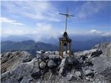
 | Jermanca - Brana (via Kamniško sedlo)
Brana is a mountain above Kamniško sedlo. From the spacious summit, which has a registration box and a small cross, there is a very beautiful vie...
3 h 45 min |
| Koča pod slapom Rinka - Brana
Brana is a mountain above Kamniško sedlo. From the spacious summit, which has a registration box and a small cross, there is a very beautiful vie...
3 h 45 min |
 | Erjavčev rovt - Mittagskogel/Kepa
Kepa (also Jepa, German: Mittagskogel) is a panoramic mountain in the western Karavanke, located on the border ridge between Slovenia and Austria...
3 h 50 min |
 | Planina Podvežak - Ojstrica (via Kocbekov dom)
Ojstrica, named for its sharp shape, rises steeply above Korošica, the Logarska Dolina valley, and Robanov Kot. From the summit, which has a regi...
4 h |
| Planina Ravne - Ojstrica (via Dolga trata and Kocbekov dom)
Ojstrica, named for its sharp shape, rises steeply above Korošica, the Logarska Dolina valley, and Robanov Kot. From the summit, which has a regi...
5 h 15 min |
 | Dom Planincev v Logarski dolini - Ojstrica (via Škarje)
Ojstrica, named for its sharp shape, rises steeply above Korošica, the Logarska Dolina valley, and Robanov Kot. From the summit, which has a regi...
4 h 10 min |
 | Planina Zapleč - Krn
Krn, at 2244 m, is the highest peak of the Krn mountain group, which rises steeply above the central part of the Soča River. From the summit, fea...
4 h 30 min |
 | The Kot Valley - Cmir
Cmir is located between two alpine valleys: Vrata and the lesser-known valley Za Cmirom. From the summit, there is a beautiful view of the peaks ...
6 h 10 min |
 | Aljažev dom v Vratih - Križ (via Sovatna)
Križ is a 2,140 m high mountain located northeast of the Kriški Podi plateau. The summit, which has a registration box with a stamp, offers a bea...
5 h |
 | Podnar / Bodenbauer - Prešernova koča na Stolu
The Prešernova koča na Stolu mountain hut is located just a few metres below the summit of the 2198 m high Mali Stol. From the hut or the nearby ...
4 h 25 min |
 | The Kot Valley - Visoka Vrbanova špica (via Staničev dom)
Visoka Vrbanova špica is located at the far southwestern end of the ridge rising above the Kot and Vrata valleys, and higher up between the Kot a...
4 h 30 min |
 | End of road on Pokljuka - Visoka Vrbanova špica
Visoka Vrbanova špica is located at the far southwestern end of the ridge rising above the Kot and Vrata valleys, and higher up between the Kot a...
5 h 45 min |
 | Sella Nevea - Rombon (along the ski piste)
Rombon is a scenic mountain above Bovec. It is particularly known for having the most artificial tunnels in Slovenia. During the First World War,...
6 h 30 min |
 | Aljažev dom v Vratih - Planja (via Sovatna)
The Planja summit is located between two alpine valleys: Mlinarica on the north side and Zadnjica on the south. From the summit, there is a beaut...
6 h 5 min |
 | Planina Blato - Veliko Špičje (via Štapce)
Veliko Špičje is the highest peak in the ridge from Travnik to Zasavska koča. From the top, there is a very nice view of the Komna plateaus, the ...
5 h 45 min |
 | Aljažev dom v Vratih - Bovški Gamsovec (via Luknja)
Bovški Gamsovec is a 2392 m high mountain in the immediate vicinity of Triglav. From the summit there is a magnificent view of Triglav and its no...
4 h 35 min |
| Aljažev dom v Vratih - Bovški Gamsovec (via Sovatna)
Bovški Gamsovec is a 2392 m high mountain in the immediate vicinity of Triglav. From the summit there is a magnificent view of Triglav and its no...
4 h 45 min |
 | Plockenpass - Monte Coglians (Hohe Warte) (via Rifugio Marinelli)
Monte Coglians (Hohe Warte) is, at 2,780 meters, the highest mountain of the Carnic Alps. From the summit, which has a cross and a bell, there is...
5 h |
| Untere Valentinalm - Monte Coglians (Hohe Warte) (via Wolayer See)
Monte Coglians (Hohe Warte) is, at 2,780 meters, the highest mountain of the Carnic Alps. From the summit, which has a cross and a bell, there is...
5 h 30 min |
| Rifugio Tolazzi - Monte Coglians (Hohe Warte) (via Rifugio Marinelli)
Monte Coglians (Hohe Warte) is, at 2,780 meters, the highest mountain of the Carnic Alps. From the summit, which has a cross and a bell, there is...
4 h 25 min |
 | Sella Nevea - Velika Črnelska špica (on ski track)
Velika Črnelska špica is located in the Kanin mountains on the border between Italy and Slovenia. From the top there is a very nice view of the V...
4 h 30 min |
| Sella Nevea - Velika Črnelska špica (via 636)
Velika Črnelska špica is located in the Kanin mountains on the border between Italy and Slovenia. From the top there is a very nice view of the V...
4 h 45 min |
 | Goldberg - Torkofel
Torkofel is the highest peak of the panoramic Jauken ridge, which extends north of the Gailtal valley. From the summit cross, there is a nice vie...
3 h 45 min |
 | Reißkofelbad - Reißkofel (via east ridge)
Reißkofel is a 2371 m high mountain in the Gailtal Alps. The summit, marked by a cross, also features a summit register. The view is particularly...
4 h 45 min |
 | Reißkofelbad - Kleiner Reißkofel
Kleiner Reißkofel is a 2,161-meter-high mountain east of Reißkofel. From the summit, where a cross stands, there are fine views of the nearby Rei...
3 h 30 min |
 | Göriach - Hochgolling (Normalanstieg)
Hochgolling is a 2863 m high peak (2862 m according to some sources), located in the heart of the Schladminger Tauern group. With its height, it ...
4 h |
 | NC Planica - Srednja Ponca / Ponza di Mezze
Srednja Ponca is a 2,228-meter-high peak rising steeply above Tamar, Planica, and Mangartska Dolina. From the summit, which has a stamp, there ar...
4 h |
 | Aljažev dom v Vratih - Pihavec (via Sovatna)
Pihavec is a spacious and panoramic peak located south of Kriški Podi. From the summit, which has a logbook and stamp, there are nice views of mo...
5 h 15 min |
 | Cave del Mole - Koštrunove špice (via Forcella Lavinal dell Orso)
Koštrunove špice is a 2,502-meter-high peak located southwest of Viš (2,666 m). From the summit, a beautiful view opens up over much of the weste...
4 h |
| Cave del Mole - Koštrunove špice (via Forcella Mose)
Koštrunove špice is a 2,502-meter-high peak located southwest of Viš (2,666 m). From the summit, a beautiful view opens up over much of the weste...
4 h |
 | Alba di Canazei - Cima Ombretta (via Passo Ombretta)
Cima Ombretta is a 3,011-meter-high peak in the Marmolada mountain group. From the summit, where a cross stands, there is the finest view of the ...
5 h |
 | Parkplatz Innerfragant - Baumbachspitze
Baumbachspitze is a 3,105-meter-high peak in the Goldberg mountain group. The summit lies directly next to the Mölltaler Gletscher ski area. Crow...
6 h |
 | Parkplatz Innerfragant - Schareck
Schareck is a 3,123-meter-high peak above the Wurtenkees glacier in the Goldberg mountain group. It is very popular due to the nearby cable car t...
6 h 15 min |
 | Coot Parking Lot - Velika Baba (Kanin) (via Skutnik)
Velika Baba is the southernmost two-thousander of the Kanin mountains. It is separated from the main ridge to the north by the saddle Med Baban, ...
4 h 20 min |
 | Plockenpass - Cima di Mezzo / Keller Warte (via Rifugio Marinelli)
Cima di Mezzo (German: Keller Warte) is a 2,713-meter-high mountain in the Carnic Alps on the border between Austria and Italy. A small cross and...
4 h 35 min |
| Rifugio Tolazzi - Cima di Mezzo / Keller Warte (via Rifugio Marinelli)
Cima di Mezzo (German: Keller Warte) is a 2,713-meter-high mountain in the Carnic Alps on the border between Austria and Italy. A small cross and...
4 h |
 | The Kot Valley - Kredarica
Kredarica is a 2,541-meter-high panoramic peak located between Triglav and Rž. From the summit, a nice view opens up towards Triglav and the surr...
5 h 5 min |
 | Rudno polje - Kredarica
Kredarica is a 2,541-meter-high panoramic peak located between Triglav and Rž. From the summit, a nice view opens up towards Triglav and the surr...
5 h 30 min |
| end of road on Pokljuka - Kredarica
Kredarica is a 2,541-meter-high panoramic peak located between Triglav and Rž. From the summit, a nice view opens up towards Triglav and the surr...
5 h 5 min |
 | Cima Sappada - Creta Forata
Creta Forata is a 2,462-meter-high mountain in the Pesarina Dolomites group of the Carnic Alps in Italy, south of Sappada. A small cross and a st...
4 h |
 | Gschnitz - Kalkwand (western approach from Gschnitza via Pinnisjoch)
Kalkwand is an extensive mountain in the eastern part of the Habicht group in the central Stubai Alps. Due to its attractive views, relatively ea...
3 h 45 min |
 | Sankt Ilgen (Der Bodenbauer) - Hochschwab
Hochschwab, at 2,277 meters, is the highest peak of its namesake mountain group in the Northern Limestone Alps. From the summit, where a cross st...
4 h 25 min |
 | Ruski križ - Lipnica (via Koča v Krnici)
Lipnica is a high-mountain peak standing in the immediate vicinity of Špik and representing its southern neighbour. It lies on the ridge that des...
4 h 15 min |