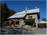
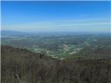
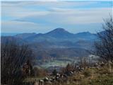
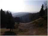
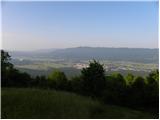
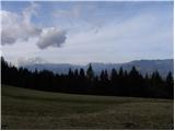
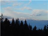
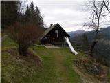
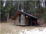
 | Tržič (Slap) - Dom pod Storžičem
Dom pod Storžičem is a mountain hut located northwest of Storžič, near the Jesenje mountain pasture. Mostly surrounded by forest, the hut offers ...
2 h 15 min |
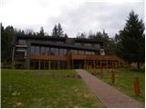
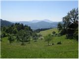
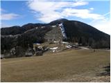
 | Vrčice - Dom na Mirni gori (by road)
The Dom na Mirni Gori mountain hut is located just a few dozen metres below the summit of Mirna Gora. From the hut or from the nearby viewpoint t...
2 h 15 min |
 | Vrčice - Dom na Mirni gori (via Škrilj)
The Dom na Mirni Gori mountain hut is located just a few dozen metres below the summit of Mirna Gora. From the hut or from the nearby viewpoint t...
2 h |
| Vrčice - Dom na Mirni gori (via Planina)
The Dom na Mirni Gori mountain hut is located just a few dozen metres below the summit of Mirna Gora. From the hut or from the nearby viewpoint t...
2 h |
 | Preddvor - Planinska koča Iskra na Jakobu (via Planinska koča pri Franciju)
The mountain hut stands below the summit of Potoška gora, offering a beautiful view of the Julian Alps and the Gorenjska plain. The nearby Cjanov...
1 h 35 min |
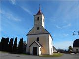
 | Gornji Grad - Sveti Lenart above Gornji Grad
The Church of St. Lenart above Gornji Grad is located at the edge of a larger meadow, more precisely on the slopes below Lepenatka and Rogatec. A...
1 h 35 min |
 | Zgornje Poljčane - Boč (via Baba)
Boč is among the last peaks in the Karawanks before they transition over Donačka gora and Macelj into the Pannonian Plain. Boč has two approximat...
1 h 55 min |
 | Zgornje Poljčane - Boč (on road and Senčna pot)
Boč is among the last peaks in the Karawanks before they transition over Donačka gora and Macelj into the Pannonian Plain. Boč has two approximat...
1 h 50 min |
| Pečica - Boč
Boč is among the last peaks in the Karawanks before they transition over Donačka gora and Macelj into the Pannonian Plain. Boč has two approximat...
2 h 30 min |
| Pečica - Boč (Senčna pot)
Boč is among the last peaks in the Karawanks before they transition over Donačka gora and Macelj into the Pannonian Plain. Boč has two approximat...
2 h 30 min |
 | Smolnik (Marotov most) - Posestvo Šumik (through valley of Lobnica)
Posestvo Šumik is located in the immediate vicinity of the Šumik nature reserve with the Lobnica valley and the Mali and Veliki Šumik waterfalls....
2 h 35 min |
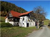
 | Sora - Brunarica Osovnik (on footpath)
The Brunarica Osovnik log cabin is located below the Osolnik peak, from where some views open onto the Polhograjsko hribovje. It is open from Fri...
1 h 35 min |
 | Žiri - Koča na Vrhu Svetih Treh Kraljev
The mountain hut is located just a few minutes below the 884-meter-high peak Vrh Svetih Treh Kraljev. It lies in the Rovtarsko hribovje and is ac...
2 h 20 min |
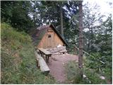
 | Gradišče - Koča pod Kremžarjevim vrhom
The mountain hut is located west of Kremžarjev vrh, just a few minutes' walk away. From the hut, a point on the Slovenian Mountain Trail, Uršlja ...
1 h 45 min |
| Slovenj Gradec - Koča pod Kremžarjevim vrhom
The mountain hut is located west of Kremžarjev vrh, just a few minutes' walk away. From the hut, a point on the Slovenian Mountain Trail, Uršlja ...
2 h 5 min |
 | Drežnica - Bivak na Črniku
Bivak na Črniku is located west of the mighty Krn, along the lower part of the Silvo Koren path. Surrounded by forest, it offers no view but prov...
1 h 45 min |
 | Trojane - Koča na Čemšeniški planini
The Dom dr. Franca Goloba mountain hut on Čemšeniška planina is located at the edge of a large grassy area from which a fine view opens toward Za...
2 h 30 min |
| Jelševica - Koča na Čemšeniški planini
The Dom dr. Franca Goloba mountain hut on Čemšeniška planina is located at the edge of a large grassy area from which a fine view opens toward Za...
2 h 30 min |
 | Dol pri Hrastniku - Planinski dom na Kalu
The Planinski dom na Kalu mountain hut, formerly known as Planinski rudarski dom na Kalu, is located below the summit of Kal (985 m). Nearby is a...
2 h |
 | Katarija - Dom na Slivni
The Dom na Zgornji Slivni mountain hut is located west of GEOSS on the eastern slopes of Pivkelj peak. Near the closed hut is the church of St. N...
2 h 15 min |
 | Moravče - Dom na Slivni (via Pivkelj)
The Dom na Zgornji Slivni mountain hut is located west of GEOSS on the eastern slopes of Pivkelj peak. Near the closed hut is the church of St. N...
2 h 50 min |
 | Grčarevec - Hunting cottage on Planinska gora (Jakobova pot)
The hunting cottage on Planinska gora is located between Grmada (873 m) and Petričev hrib (937 m). A macadam road from Lohača (a village near Pla...
2 h |
 | Vransko - Dom na Čreti
The Dom na Čreti mountain hut is located north of Vransko on the central part of the Dobroveljska planota plateau. Near the hut are two small chu...
1 h 45 min |
 | Kokarje (ŠRC Laze) - Dom na Čreti (via Tajna)
The Dom na Čreti mountain hut is located north of Vransko on the central part of the Dobroveljska planota plateau. Near the hut are two small chu...
1 h 40 min |
| Kokarje (ŠRC Laze) - Dom na Čreti (via Dom na Farbanci)
The Dom na Čreti mountain hut is located north of Vransko on the central part of the Dobroveljska planota plateau. Near the hut are two small chu...
2 h |
| Potok (Mostni graben) - Dom na Čreti (via Dom na Farbanci)
The Dom na Čreti mountain hut is located north of Vransko on the central part of the Dobroveljska planota plateau. Near the hut are two small chu...
1 h 35 min |
 | Črna na Koroškem - Andrejev dom na Slemenu (by road)
The Andrejev dom mountain hut is situated on the top of a grassy ridge from which there is a nice view to the south towards the hills between Moz...
2 h 30 min |
 | Idrija - Koča na Hleviški planini (hunting path)
The Koča na Hleviški planini mountain hut is located just below the 908 m high peak of Hleviška planina. From the hut, a control point on the Slo...
1 h 35 min |
 | Divje jezero - Koča na Hleviški planini (via Prižnica)
The Koča na Hleviški planini mountain hut is located just below the 908 m high peak of Hleviška planina. From the hut, a control point on the Slo...
2 h 20 min |
| Idrija - Koča na Hleviški planini (via Kodrov rovt)
The Koča na Hleviški planini mountain hut is located just below the 908 m high peak of Hleviška planina. From the hut, a control point on the Slo...
1 h 50 min |
 | Pivola (Reka) - Mariborska koča (via Petkovo sedlo and waterfall Skalca)
Mariborska koča is the first control point of the Slovenian Mountain Trail (SPP). It is located north of Slivniško Pohorje and west of Hočko Poho...
2 h 30 min |
 | Pivola (Reka) - Mariborska koča (via Hočka koča)
Mariborska koča is the first control point of the Slovenian Mountain Trail (SPP). It is located north of Slivniško Pohorje and west of Hočko Poho...
2 h 15 min |
 | Pivola (Reka) - Mariborska koča (via Petkovo sedlo)
Mariborska koča is the first control point of the Slovenian Mountain Trail (SPP). It is located north of Slivniško Pohorje and west of Hočko Poho...
2 h 15 min |
 | Leše - Koča na Naravskih ledinah (via Kot pri Prevaljah)
Koča na Naravskih ledinah is located on the northern side of the western ridge of Uršlja gora. The hut, accessible by car, offers no views due to...
2 h 40 min |
| Prevalje - Koča na Naravskih ledinah (by road)
Koča na Naravskih ledinah is located on the northern side of the western ridge of Uršlja gora. The hut, accessible by car, offers no views due to...
2 h 55 min |
 | Ortnek - Koča pri Sveti Ani on Mala gora
The Planinska Koča pri Sveti Ani mountain hut is located near the namesake church on the slopes of Mala Gora above Ribnica. From the hut or its i...
2 h 45 min |
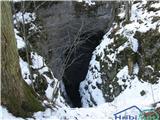 | Kočevje - Ledena jama on Stojna (Kalan way)
The Ledena jama cave is located south of the Koča pri Jelenovem studencu cottage, in the midst of the extensive forests of Stojna. Over 100 m dee...
1 h 45 min |
 | Vitovlje - Sekulak (via Vitovlje Lake)
Sekulak is a viewpoint on a side ridge of the Čavenski massif. Because Sekulak protrudes from the main ridge line, it offers a wonderful view of ...
1 h 40 min |
 | Vitovlje - Kopitnik (na Čavnu) (via Sekulak)
Kopitnik, known as a takeoff point for hang gliders and paragliders, is located above the village of Vitovlje above the Vipava Valley. Near the t...
2 h 30 min |
 | Razdrto - Sveti Hieronim (na Nanosu)
The Church of St. Jerome is located at an altitude of 1020 meters on the southern edge of the Nanos plateau, just above the steep slopes of Reber...
1 h 45 min |
 | Vrtovin - Bivak Črna peč
Bivak Črna peč is a closed-type bivouac owned by the Čaven hunting family. From the bivouac, located below the steep slopes of Črna peč, there is...
1 h 50 min |
 | Buzet Railway Station - Planinarska kuća Žbevnica (on IPP)
The Žbevnica mountain hut is situated below the summit of the scenic 1,014-meter-high Žbevnica....
2 h 30 min |
 | Železniki - Prtovč (via Draoboslovica)
Prtovč is a small hill village located west of Železniki. On a panoramic grassy ridge right next to the village stands the Church of Mary Help of...
1 h 45 min |
 | Mežica - Koča na Pikovem (via saddle Vrh šteng)
The Koča na Pikovem mountain hut is situated above Podpeca, with the Church of St. Helena and a chapel nearby, and a volleyball court a bit farth...
2 h 15 min |
| Mežica - Koča na Pikovem (via homestead Jesenik)
The Koča na Pikovem mountain hut is situated above Podpeca, with the Church of St. Helena and a chapel nearby, and a volleyball court a bit farth...
2 h |
| Mežica - Koča na Pikovem (old path)
The Koča na Pikovem mountain hut is situated above Podpeca, with the Church of St. Helena and a chapel nearby, and a volleyball court a bit farth...
2 h |
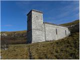
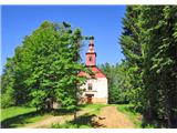
 | Dravograd - Church of St. John the Baptist on Ojstrica
The Church of St. John the Baptist on Ojstrica is located on the edge of panoramic pastures where highland cattle usually graze. From the church ...
1 h 45 min |
 | Letuš - Holy Mother of God on Čreta
The Church of the Holy Mother of God on Čreta is located west of the lesser-known forested peak Vrhe. From the church or its immediate surroundin...
2 h 50 min |
 | Kokarje (ŠRC Laze) - Holy Mother of God on Čreta (via Tajna)
The Church of the Holy Mother of God on Čreta is located west of the lesser-known forested peak Vrhe. From the church or its immediate surroundin...
1 h 40 min |
| Kokarje (ŠRC Laze) - Holy Mother of God on Čreta (via Dom na Farbanci)
The Church of the Holy Mother of God on Čreta is located west of the lesser-known forested peak Vrhe. From the church or its immediate surroundin...
2 h |
| Potok (Mostni graben) - Holy Mother of God on Čreta (via Dom na Farbanci)
The Church of the Holy Mother of God on Čreta is located west of the lesser-known forested peak Vrhe. From the church or its immediate surroundin...
1 h 35 min |
 | Zabočevo - Rakitna
Rakitna is a popular excursion spot for residents of the Ljubljana Marshes and surrounding areas. The village center features the Church of the H...
1 h 45 min |
 | Lavamünd - St. Lorenzen (Lorenzenberg)
The Church of St. Lorenzen is located on the edge of the village Lorenzenberg, east of Labot/Lavamünd. From the church or its immediate surroundi...
2 h |
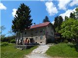
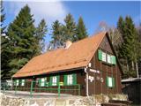
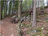
 | Tržič - Zavetišče na Kalu (via Kamnek)
The Zavetišče na Kalu shelter is located on the edge of the namesake saddle, more precisely between the Bela peč and Kobel peaks. From the saddle...
2 h 40 min |
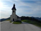
 | Vače - Planinski dom na Zasavski Sveti gori (on a slope)
The Planinski dom na Zasavski Sveti gori mountain hut is located just a few tens of meters below the summit of Zasavska Sveta gora. From the hut ...
2 h 30 min |
| Vače - Planinski dom na Zasavski Sveti gori (on the ridge)
The Planinski dom na Zasavski Sveti gori mountain hut is located just a few tens of meters below the summit of Zasavska Sveta gora. From the hut ...
2 h 35 min |
 | Loke - Planinski dom Vrhe
The Planinski dom Vrhe mountain hut is situated on the southeast slopes of Kisovec peak, from where a nice view opens up to the nearby Javor. Nea...
1 h 50 min |
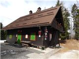
 | Hayrack (Laška vas - Pečovje) - Vrunčev dom na Svetini (via chapel at Mary)
Vrunčev dom na Svetini mountain hut is located at a pleasant vantage point above Štore or the settlement of Svetina. It was built by the Štore ve...
1 h 35 min |
 | Bezgovica - Firstov rep
Firstov rep lies north of Loška stena, where a summit register box with a logbook and stamp is located. From the register box on Firstov rep, a f...
2 h 15 min |
 | Mežica - Bivak Suška bajta
Bivak Suška bajta is located between Suški vrh and Kot pri Prevaljah. Nearby Suška bajta there are numerous verses, figures of Tomažej (Tomažej -...
2 h 45 min |
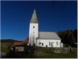
 | Radlje ob Dravi - Sveti Primož above Muta
Sveti Primož above Muta is a dispersed settlement rising north of Muta. The Church of St. Primož and Felicijan, located on the ridge between Prim...
2 h 30 min |
 | Muta (Spodnja Muta) - St. Lorenzen ob Eibiswald
The Church of St. Lovrenc is located on the Austrian side of the Kozjak / Poßruck hills, specifically in the village of Sv. Lovrenc / St. Lorenze...
2 h 55 min |
| Bistriški jarek (Verdinek) - St. Lorenzen ob Eibiswald
The Church of St. Lovrenc is located on the Austrian side of the Kozjak / Poßruck hills, specifically in the village of Sv. Lovrenc / St. Lorenze...
2 h 45 min |
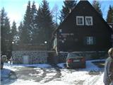
 | Muta (Spodnja Muta) - Zavetišče Onuk - Glavar
The Zavetišče Onuk - Glavar shelter is located below Bricnik peak in the settlement of Sveti Primož above Muta. It offers the KPP (Koroška Planin...
1 h 35 min |
 | Radlje ob Dravi - Zavetišče Onuk - Glavar
The Zavetišče Onuk - Glavar shelter is located below Bricnik peak in the settlement of Sveti Primož above Muta. It offers the KPP (Koroška Planin...
2 h 15 min |
 | Bistriški jarek (border crossing Muta) - Church of St. Simon and Judah Tadej (Pernice)
Pernice is a settlement located between Gortina, Kozji vrh and Bistriški jarek. In Pernice there is the church of St. Simon and Jude Thaddeus, a ...
1 h 50 min |
| Bistriški jarek (Glasbeni dom) - Church of St. Simon and Judah Tadej (Pernice)
Pernice is a settlement located between Gortina, Kozji vrh and Bistriški jarek. In Pernice there is the church of St. Simon and Jude Thaddeus, a ...
1 h 45 min |
 | Muta (Zgornja Muta) - Church of St. Simon and Judah Tadej (Pernice)
Pernice is a settlement located between Gortina, Kozji vrh and Bistriški jarek. In Pernice there is the church of St. Simon and Jude Thaddeus, a ...
2 h 45 min |
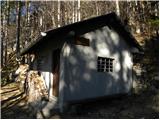
 | Radlje ob Dravi - Kapunerhütte (via Župank and hut of amateur radio operators)
Kapunerhütte is a small mountain hut located on the Austrian side of Kapunar. As it lies in the forest, it offers no scenic views....
2 h 45 min |
| Radlje ob Dravi - Kapunerhütte (via old castle and hut of amateur radio operators)
Kapunerhütte is a small mountain hut located on the Austrian side of Kapunar. As it lies in the forest, it offers no scenic views....
2 h 45 min |
 | Brezno - Sveti Urban (Radelca) (along Remšniški potok)
The Church of St. Urban on Radelca stands on the southern slopes of the border ridge Radelj. Built in the mid-17th century amid nearby forest, it...
2 h 30 min |
 | Bled (Velika Zaka) - Forestry cottage Mali Vokel
The forestry cottage Mali Vokel is located on the eastern slopes of Pokljuka, specifically along the marked trail from Bled to Pokljuka. There ar...
2 h 50 min |
| Bohinjska Bela (St. Marjeta) - Forestry cottage Mali Vokel
The forestry cottage Mali Vokel is located on the eastern slopes of Pokljuka, specifically along the marked trail from Bled to Pokljuka. There ar...
2 h 35 min |
 | Rein - Mühlbacher Hütte (Hunting path / Jägersteig)
The Mühlbacher Hütte mountain hut stands at 996 m above sea level above the Mühlbacher Graben near Rein and is a popular destination for cyclists...
2 h |
 | Rein - Mühlbacher Hütte (via Hochstein)
The Mühlbacher Hütte mountain hut stands at 996 m above sea level above the Mühlbacher Graben near Rein and is a popular destination for cyclists...
2 h 15 min |
 | Kropa - Partisan cyclostyle Tehnika Meta (via Berigla)
The partisan printing press Tehnika Meta on Jelovica is located at approximately 1,100 m elevation. At the site of the former Tehnika Meta there ...
1 h 50 min |
 | Lovrenc na Pohorju - Sveti Ignacij (Rdeči Breg) (via Povh and Brabar)
The Church of St. Ignacij is situated on the periphery of the settlement Rdeči Breg, which rises northwest of Lovrenc na Pohorju and only a littl...
2 h 25 min |
 | Lovrenc na Pohorju - Sveti Ignacij (Rdeči Breg)
The Church of St. Ignacij is situated on the periphery of the settlement Rdeči Breg, which rises northwest of Lovrenc na Pohorju and only a littl...
2 h 5 min |
| Janževski Vrh (Uran) - Sveti Ignacij (Rdeči Breg) (via Brabar)
The Church of St. Ignacij is situated on the periphery of the settlement Rdeči Breg, which rises northwest of Lovrenc na Pohorju and only a littl...
1 h 35 min |
| Puščava - Sveti Ignacij (Rdeči Breg)
The Church of St. Ignacij is situated on the periphery of the settlement Rdeči Breg, which rises northwest of Lovrenc na Pohorju and only a littl...
2 h 50 min |
| Lovrenc na Pohorju - Sveti Ignacij (Rdeči Breg) (via Kapus)
The Church of St. Ignacij is situated on the periphery of the settlement Rdeči Breg, which rises northwest of Lovrenc na Pohorju and only a littl...
2 h 35 min |
| HE Ožbalt - Sveti Ignacij (Rdeči Breg)
The Church of St. Ignacij is situated on the periphery of the settlement Rdeči Breg, which rises northwest of Lovrenc na Pohorju and only a littl...
2 h 45 min |
 | Zgornja Bistrica (Center Vintgar) - Majalova Chapel (via Bistriški vintgar)
Majalova Chapel is located south of the Majal homestead, from where a nice view opens up onto the nearby surroundings....
2 h 45 min |
 | Puščava - Hunting cottage Klančnik
The Hunting Cottage Klančnik is located just below the Klančnik peak on the panoramic grassy slopes of Rdeči Breg....
2 h 20 min |
| Lovrenc na Pohorju - Hunting cottage Klančnik (via Kapus)
The Hunting Cottage Klančnik is located just below the Klančnik peak on the panoramic grassy slopes of Rdeči Breg....
2 h 5 min |
 | Lovrenc na Pohorju - Hunting cottage Klančnik (via Povh, Brabar and Hudej)
The Hunting Cottage Klančnik is located just below the Klančnik peak on the panoramic grassy slopes of Rdeči Breg....
2 h 20 min |
| Janževski Vrh (Uran) - Hunting cottage Klančnik (via Sveti Ignacij)
The Hunting Cottage Klančnik is located just below the Klančnik peak on the panoramic grassy slopes of Rdeči Breg....
1 h 55 min |
| HE Ožbalt - Hunting cottage Klančnik
The Hunting Cottage Klančnik is located just below the Klančnik peak on the panoramic grassy slopes of Rdeči Breg....
2 h 15 min |
 | Vitanje - Chapel of Mary's Hand (Stenica)
The Chapel of Mary's Hand is located a few minutes below the summit of Stenica on Mala gora, which rises steeply above the settlement of Vitanje....
1 h 40 min |
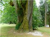
 | Zgornja Bistrica (Center Vintgar) - Marolt fir tree (Bistriški vintgar)
The Marolt fir tree is slowly rotting today. Until 2010, when it collapsed in a fire, it was the thickest fir tree in Europe, with a circumferenc...
1 h 45 min |
 | Pivola (Reka) - Sveti Bolfenk (Mariborsko Pohorje) (via Petkovo sedlo and Mariborska koča)
The Church of St. Bolfenk on Mariborsko Pohorje is located near the upper station of the funicular and near the Hotel Bellevue....
2 h 50 min |
 | Stubenbergsee - Mariabrunn (via Kulmkögerl)
Mariabrunn is a small chapel located on the western slopes of Kulm peak....
1 h 53 min |
 | Zgornja Bistrica (Center Vintgar) - Ponds Devin in Ošelj (via Bistriški vintgar)
The Devin Ponds in Ošelj are located on the outskirts of the settlement Ošelj in the southeastern part of Pohorje....
2 h 15 min |
 | Zgornja Bistrica (Center Vintgar) - Pond west of Ošelj (via Bistriški vintgar)
The pond west of Ošelj lies among the Pohorje forests, near the settlements of Smrečno and Ošelj....
2 h 5 min |
 | Smolnik (Marotov most) - Sveta Marija (Smolnik) (through valley of Lobnica)
The Church of Holy Mary is situated at the edge of the forest and on the periphery of the hamlet Hlebovo, near the settlement Smolnik....
2 h 5 min |
 | Pivola (Reka) - Hotel Tisa (Poštarski dom) (via Petkovo sedlo)
Hotel Tisa, the former Poštarski dom, is situated at the edge of the Hočko Pohorje forests. The hotel, known for its original Pohorje omelette, o...
1 h 45 min |
| Fram - Hotel Tisa (Poštarski dom) (via Petkovo sedlo)
Hotel Tisa, the former Poštarski dom, is situated at the edge of the Hočko Pohorje forests. The hotel, known for its original Pohorje omelette, o...
2 h 30 min |
 | Bistriški jarek (Glasbeni dom) - Arl's Pine
Arlov bor has been protected since 2010 as a local, municipal, and natural landmark due to its unique and unusual growth.From the pine, where a v...
2 h |
| Bistriški jarek (border crossing Muta) - Arl's Pine
Arlov bor has been protected since 2010 as a local, municipal, and natural landmark due to its unique and unusual growth.From the pine, where a v...
2 h 5 min |
| Muta (Zgornja Muta) - Arl's Pine
Arlov bor has been protected since 2010 as a local, municipal, and natural landmark due to its unique and unusual growth.From the pine, where a v...
2 h 30 min |
 | Črna na Koroškem - Najevska lipa
The Najevska linden, regarded as Slovenia's thickest tree for decades, stands in Ludranski Vrh in the Municipality of Črna na Koroškem. It is a s...
2 h 10 min |