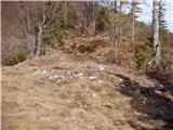
 | Brezje pri Tržiču - Vaško
Vaško is a little-known mountain in the southeastern ridge of Dobrča. From the summit, there is a nice view toward Jelovica and the Julian Alps. ...
55 min |
 | Brezje pri Tržiču - Vaško (eastern path)
Vaško is a little-known mountain in the southeastern ridge of Dobrča. From the summit, there is a nice view toward Jelovica and the Julian Alps. ...
1 h 5 min |
| Water storage Žegnani studenec - Vaško
Vaško is a little-known mountain in the southeastern ridge of Dobrča. From the summit, there is a nice view toward Jelovica and the Julian Alps. ...
1 h 5 min |
 | Podgorje - Kojnik (via hunting cottage)
Kojnik is a partly forested peak located in the southern part of Podgorski Kras near the Slovenian-Croatian border. From the summit, which has a ...
1 h 30 min |
 | Planina - Petričev hrib
Petričev hrib is a peak north of Postojna and west of Planina. From the summit, which has a logbook box, there is a nice view of the Notranjska h...
1 h 30 min |
 | Tržič - Kamnek (Milanova pot)
Kamnek (Kamnik on maps, also sometimes Kamnjek) is a panoramic peak above Tržič....
1 h 5 min |
 | Tržič (Slap) - Kamnek (via Dobrivc)
Kamnek (Kamnik on maps, also sometimes Kamnjek) is a panoramic peak above Tržič....
1 h |
 | Lučine - Sivka
Sivka is a grassy peak at the far western end of Polhograjsko hribovje. On clear days, it offers breathtaking views from Snežnik across Javorniki...
50 min |
 | Prelesje - Sivka
Sivka is a grassy peak at the far western end of Polhograjsko hribovje. On clear days, it offers breathtaking views from Snežnik across Javorniki...
1 h |
| Novi Lazi - Livoldski vrh
Livoldski vrh is a forest-covered hill located on the southeastern part of Stojna. The summit has a logbox and stamp....
1 h 10 min |
 | Planina - Grmada (Planinska gora)
Grmada is an 873-meter-high peak rising west of Planinsko polje. Although the summit is forested, a viewpoint just below it offers a stunning vie...
1 h |
 | Planina (Dolnja Planina) - Grmada (Planinska gora) (via Zavrtniki)
Grmada is an 873-meter-high peak rising west of Planinsko polje. Although the summit is forested, a viewpoint just below it offers a stunning vie...
1 h 5 min |
| Planina (Dolnja Planina) - Grmada (Planinska gora) (via Sv. Duh)
Grmada is an 873-meter-high peak rising west of Planinsko polje. Although the summit is forested, a viewpoint just below it offers a stunning vie...
1 h 5 min |
 | Poljana - Smolnik
Smolnik is a steep 1075-meter-high peak a solitary summit below Valvasorjev dom hut rising above the Zavrh (Završnica) valley, with views of St...
1 h 15 min |
 | Poljana - Smolnik (steep path)
Smolnik is a steep 1075-meter-high peak a solitary summit below Valvasorjev dom hut rising above the Zavrh (Završnica) valley, with views of St...
1 h |
 | Oblakov Vrh - Hudournik
Hudournik is a 1,148-meter-high peak on the northern edge of the Vojskarska planota plateau, which lies between the valleys of the Idrijca, Kanom...
1 h 30 min |
 | Smrečje - Goli vrh
Goli vrh (also Golni vrh on maps) is an indistinct, forest-covered peak above the dispersed settlement of Goli Vrh. There is no view from the sum...
1 h 30 min |
 | Bohinjska Češnjica - Rudnica
Rudnica is a panoramic mountain located between the Lower and Upper Bohinj Valleys. From the summit, where there is a register box with a stamp a...
1 h 30 min |
| Srednja vas (Senožeta) - Rudnica
Rudnica is a panoramic mountain located between the Lower and Upper Bohinj Valleys. From the summit, where there is a register box with a stamp a...
1 h 30 min |
 | Ledinsko Razpotje - Gradišče (above Spodnja Idrija) (steep path)
Gradišče is a 998 m high peak that separates the Ledinska plateau in the northwestern part of Rovtarsko hribovje from the Idrijca valley. A telev...
1 h |
 | Ledinsko Razpotje - Gradišče (above Spodnja Idrija) (gentle path)
Gradišče is a 998 m high peak that separates the Ledinska plateau in the northwestern part of Rovtarsko hribovje from the Idrijca valley. A telev...
1 h 15 min |
 | Nemilje - Sveti Mohor (Zabrekve)
The Church of St. Mohor is located on a 952 m high hill between Zgornja Besnica and Selci. From the church or its nearby surroundings, there is a...
1 h 20 min |
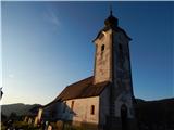
 | Njivica - Sveti Primož in Felicijan (Jamnik)
The Church of St. Primož and Felicijan at Jamnik is located on a scenic grassy ridge rising between Kropa and Podblica. From the church or its ne...
1 h 10 min |
 | Brezovica - Sveti Primož in Felicijan (Jamnik)
The Church of St. Primož and Felicijan at Jamnik is located on a scenic grassy ridge rising between Kropa and Podblica. From the church or its ne...
1 h 20 min |
| Češnjica pri Kropi - Sveti Primož in Felicijan (Jamnik) (via Berigla)
The Church of St. Primož and Felicijan at Jamnik is located on a scenic grassy ridge rising between Kropa and Podblica. From the church or its ne...
1 h 20 min |
| Kropa (Slovenska peč) - Sveti Primož in Felicijan (Jamnik)
The Church of St. Primož and Felicijan at Jamnik is located on a scenic grassy ridge rising between Kropa and Podblica. From the church or its ne...
1 h 10 min |
 | Nemilje - Sveti Primož in Felicijan (Jamnik) (on marked path)
The Church of St. Primož and Felicijan at Jamnik is located on a scenic grassy ridge rising between Kropa and Podblica. From the church or its ne...
50 min |
 | Rodik - Sveti Socerb (Artviže)
The Church of St. Socerb is located on a panoramic hill above the village of Artviže, which at 817 meters is the highest peak of the Brkini. From...
1 h 20 min |
 | Gorenji Novaki (Mrovlje) - Škofje
Škofje is a 973-meter-high peak located above the villages of Čeplez, Planina pri Cerknem, and Podpleče. The summit itself, marked by a small con...
1 h |
 | Trojane - Lipovec
Lipovec is an 848-meter-high peak located above the pastures of Lipovec. On clear days, the summit offers views of the Posavsko hribovje, Kum, Me...
1 h 30 min |
 | Tržič (Čegelše) - Veliki vrh above Završnik
Veliki vrh above Završnik is a 968 m high mountain located in the Pirmance ridge, north to northeast of Tržič. From the grassy summit, which feat...
1 h 20 min |
| Podljubelj - Veliki vrh above Završnik
Veliki vrh above Završnik is a 968 m high mountain located in the Pirmance ridge, north to northeast of Tržič. From the grassy summit, which feat...
1 h 20 min |
 | Čepovan (Želinc) - Vrh Skopice
Vrh Skopice, also known as Skopica, is a panoramic peak located between the Čepovan Valley, the Idrijca River valley, and the Trebuščica River va...
50 min |
 | Brezje nad Kamnikom - Vovar (western way)
A viewless hill in front of the Kamnik mountains. In recent times, due to storms, it is crisscrossed with cart tracks for log extraction.Below th...
1 h |
| Brezje nad Kamnikom - Vovar (northern way)
A viewless hill in front of the Kamnik mountains. In recent times, due to storms, it is crisscrossed with cart tracks for log extraction.Below th...
1 h |
 | Žiri - Javorč
Javorč is a 901-meter-high peak located northeast of Žiri. The summit, featuring a logbox with a logbook, lies at the edge of a larger clearing, ...
1 h 15 min |
 | Babni Vrt - Gradišče (Pustinjak) (through the forest and past sv. Lovrenc)
Gradišče or Pustinjak (also Gradišče nad Bašljem) is an 871-meter-high peak located above the Belica stream, which lies below the 2,132-meter-hig...
1 h 25 min |
 | Blejska Dobrava (cemetery) - Hom at Bled (via Katarina)
Hom is an 834-meter-high hill rising north above the villages of Zasip and Podhom near Bled, or south of the village Blejska Dobrava near Jesenic...
1 h 25 min |
 | Blejska Dobrava (cemetery) - Hom at Bled (on east slope)
Hom is an 834-meter-high hill rising north above the villages of Zasip and Podhom near Bled, or south of the village Blejska Dobrava near Jesenic...
1 h 5 min |
 | Poljane (Spodnje Gorje) - Boršt (by road)
Boršt is a 931-meter-high vegetated peak located 4 km northwest of Bled, or east of the Mežakla Plateau. Between it and the neighboring peak Hom ...
1 h |
 | Kočna - Boršt (via Vrše)
Boršt is a 931-meter-high vegetated peak located 4 km northwest of Bled, or east of the Mežakla Plateau. Between it and the neighboring peak Hom ...
1 h 20 min |
 | Trate (Blejska Dobrava) - Boršt
Boršt is a 931-meter-high vegetated peak located 4 km northwest of Bled, or east of the Mežakla Plateau. Between it and the neighboring peak Hom ...
1 h |
 | Ukova (Jesenice) - Mirca (via Pekova plan'ca)
Mirca (Merca in dialect) is one of the peaks in the southern Karawanks at an elevation of 1025 meters. It rises north above the center of Jesenic...
1 h 20 min |
 | Murova - Mirca
Mirca (Merca in dialect) is one of the peaks in the southern Karawanks at an elevation of 1025 meters. It rises north above the center of Jesenic...
1 h 10 min |
 | Jeršiče - Baba (at Javorniki)
Baba is a 1,085-meter-high peak located between the Javorniki ridge and Sveta Trojica. From its grassy summit, nice views open up to the Javornik...
1 h 30 min |
 | Možjanca - Kopa (Partizanski vrh)
Kopa, also known as Partizanski vrh, is a 1,024-meter-high mountain located west of the Davovec saddle, which itself lies west to southwest of Kr...
1 h 30 min |
 | Možjanca - Skutman
Skutman is a lesser-known peak above the left bank of the Kokra River and north of Štefanja Gora. The summit is marked by a metal plaque reading ...
1 h 25 min |
 | Možjanca - Skutman (via Zapečnikova planina)
Skutman is a lesser-known peak above the left bank of the Kokra River and north of Štefanja Gora. The summit is marked by a metal plaque reading ...
1 h 25 min |
| Kokra (resting place Kokra-sotočje) - Skutman
Skutman is a lesser-known peak above the left bank of the Kokra River and north of Štefanja Gora. The summit is marked by a metal plaque reading ...
1 h 10 min |
 | Bele Vode (Kovač) - Sveti Križ above Bele Vode (on south ridge)
The Church of St. Cross is located on Kriška gora, formerly called Oslovska gora. Kriška gora rises above Beli Vodi, or above the streams Ljubija...
1 h 10 min |
 | Poljšica pri Gorjah (Zatrata) - Hotunjski vrh (on footpath)
Hotunjski vrh is a 1,107-meter-high panoramic peak located above the Zatrnik ski slope. From the summit, where there is a summit register box and...
1 h 30 min |
 | Mežica - Andrejev vrh (by cart track)
Andrejev vrh is a forest-covered peak located between Mežica and Leše. On the summit there is a bench and a summit register box with a logbook....
1 h 15 min |
| Mežica - Andrejev vrh (past the chapel)
Andrejev vrh is a forest-covered peak located between Mežica and Leše. On the summit there is a bench and a summit register box with a logbook....
1 h 20 min |
| Leše - Andrejev vrh (past Leše churches and on cart track)
Andrejev vrh is a forest-covered peak located between Mežica and Leše. On the summit there is a bench and a summit register box with a logbook....
1 h 30 min |
 | Železniki - Sveti Križ above Selca (via Štalca)
The Church of the Holy Cross above Selca is situated on a panoramic hill from which a beautiful view opens up over part of the Škofjeloško hribov...
1 h 15 min |
 | Hunting lodge LD Libeliče - Šteharski vrh (Šteharnikov vrh)
Šteharski vrh (also Šteharnikov vrh or Črneška gora) is a 1,018 m high mountain located in the southeastern part of the Strojna range, between th...
1 h 30 min |
 | Senično - Planica (Paragliding site Gozd) (gentle path)
Planica is a 926-meter peak located above the village of Gozd. From the summit, where the JPK Kriška gora cottage stands, a nice view opens up ov...
1 h 15 min |
| Senično - Planica (Paragliding site Gozd) (steep path)
Planica is a 926-meter peak located above the village of Gozd. From the summit, where the JPK Kriška gora cottage stands, a nice view opens up ov...
1 h 10 min |
| Pristava - Planica (Paragliding site Gozd)
Planica is a 926-meter peak located above the village of Gozd. From the summit, where the JPK Kriška gora cottage stands, a nice view opens up ov...
1 h 20 min |
 | Šenturška Gora - Prgozdnik (Martinova pot)
Prgozdnik is a 1013 meters high peak, which is situated on the eponymous ridge, between the settlements Ambrož pod Krvavcem, Šenturška Gora, Apno...
1 h 5 min |
 | Apno - Prgozdnik (Martinova pot)
Prgozdnik is a 1013 meters high peak, which is situated on the eponymous ridge, between the settlements Ambrož pod Krvavcem, Šenturška Gora, Apno...
1 h 10 min |
 | Koprivna (Šumel) - Sveti Jakob in Koprivna
The Church of St. Jakob in Koprivna stands on a panoramic rise above the right bank of the Meža River. It offers a beautiful view towards Raduha ...
50 min |
 | Bukovo - Črvov vrh
Črvov Vrh, also known as Črvov Grič, is the highest peak of the Šentviška Planota at 974 metres. The plateau rises above the right bank of the Id...
1 h 30 min |
| Šentviška Gora - Črvov vrh
Črvov Vrh, also known as Črvov Grič, is the highest peak of the Šentviška Planota at 974 metres. The plateau rises above the right bank of the Id...
1 h 10 min |
 | Bukovo - Bukovski vrh
Bukovski Vrh (918 m) lies above the settlement of Bukovski Vrh, more precisely above the Pri Pircu homestead. From the grassy summit there is a f...
1 h 20 min |
| Šentviška Gora - Bukovski vrh
Bukovski Vrh (918 m) lies above the settlement of Bukovski Vrh, more precisely above the Pri Pircu homestead. From the grassy summit there is a f...
1 h 30 min |
 | Ledinica - Krog (Ledinski grič)
Krog is a 940-metre-high peak on the western part of the Ledinski grič ridge, between the streams Jerešča and Ledinščicaboth left tributaries of ...
1 h 15 min |
 | Ledinsko Razpotje - Krog (Ledinski grič)
Krog is a 940-metre-high peak on the western part of the Ledinski grič ridge, between the streams Jerešča and Ledinščicaboth left tributaries of ...
1 h 30 min |
 | Dovje - Blažčeva skala (western path)
Blažčeva skala is a 1,091-meter-high hill located northeast of Mojstrana and Dovje. The summit, known more among climbers than hikers due to the ...
1 h |
 | Veliko Tinje - Repnikov vrh
Repnikov vrh is a 988-meter-high peak on Pohorje, located between Planina pod Šumikom and Urh. The summit is in the middle of the forest, along a...
1 h 25 min |