 | Cerknica (Senior citizens home) - Slivnica (Zatrepi - Slivnica)
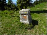
Slivnica is a 1,114-meter-high peak located north of the Cerknica Field and the intermittent Lake Cerknica. The summit itself is quite rounded, p...
1 h 30 min |
 | Kališe - Kranjska reber
Kranjska reber, also known as Vrh Kašne planine (1435 m), is a mountain of volcanic origin. From the summit, which has a registration box with a ...
1 h 30 min |
| Volovljek - Kranjska reber (on unmarked path)
Kranjska reber, also known as Vrh Kašne planine (1435 m), is a mountain of volcanic origin. From the summit, which has a registration box with a ...
1 h 15 min |
 | Kosmačev preval - Črna gora
The summit is located between the Kot and Vrata valleys. A bivouac with two sleeping places stands on the summit. The view is beautiful towards K...
1 h 15 min |
 | Kajfežev rob - Kamniški vrh
Kamniški vrh is a 1259-metre-high mountain located north of Kamnik, more precisely between Stahovica and the Korošica valley. From the summit, wh...
1 h 15 min |
 | Preval Hlevišče - Koprivnik (via Brdo)
Koprivnik is a 1393-meter-high mountain located between Blegoš and Mladi vrh. From the summit, which has a registration box and a stamp, the view...
2 h |
 | Avsa - Mrzli vrh (on Matajur)
Mrzli vrh is a 1358-meter-high peak located in the Matajur range. From the summit, where there is a panorama board and a summit register box with...
1 h 25 min |
 | Gorenje - Gora (Sveti Lovrenc) (gentle path)
Gora, or Sveti Lovrenc, is a peak above Studeno, a village north of Postojna that serves as a suitable starting point for the ascent to this pano...
1 h 45 min |
 | Zatrnik - Galetovec
Galetovec is an indistinct peak on the southeastern part of the Pokljuka plateau. From the summit, which has a logbook, there is a nice view of t...
2 h |
 | Laze - Črni vrh above Novaki
Črni vrh, the highest point of the popular Cerkno ski center, is located northeast of Novaki. Near the summit, where an artificial lake has been ...
2 h |
 | Bač - Kršičevec
Kršičevec is a lesser-known mountain located east of Jurišče village in the Pivka basin. From its grassy summit, which has a logbook box with a s...
2 h 15 min |
 | Preval Hlevišče - Mladi vrh
Mladi vrh is the higher neighbor of the better-known Stari vrh, separated from it by a saddle. Covered in sparse beech forest, the summit offers ...
1 h 45 min |
 | Begunje (Krpin) - Smokuški vrh (on cart track and past sv. Peter)
Smokuški vrh is a panoramic mountain located on the ridge between the Završnica Valley and the Gorenjska plain. From the summit, where there is a...
1 h 50 min |
 | Begunje (Krpin) - Smokuški vrh (by road)
Smokuški vrh is a panoramic mountain located on the ridge between the Završnica Valley and the Gorenjska plain. From the summit, where there is a...
1 h 35 min |
 | Begunje (Krpin) - Smokuški vrh (through Blatnica Gorge)
Smokuški vrh is a panoramic mountain located on the ridge between the Završnica Valley and the Gorenjska plain. From the summit, where there is a...
1 h 40 min |
 | Cenc - Špičasti vrh (on road over Novina)
Špičasti vrh is a forest-covered mountain located south of the village of Zadlog. To ensure the summit is not without a view, a 13-meter-high woo...
1 h 30 min |
 | Dom Pristava in Javorniški Rovt - Španov vrh
Španov vrh is a 1334-meter-high mountain in the Karavanke that rises between Javorniški Rovt and Planina pod Golico. From the scenic summit, acce...
1 h 30 min |
| Planina pod Golico - Španov vrh
Španov vrh is a 1334-meter-high mountain in the Karavanke that rises between Javorniški Rovt and Planina pod Golico. From the scenic summit, acce...
1 h 15 min |
 | Jesenice (Ukova) - Jelenkamen (via Dole)
Jelenkamen is a peak in the northern Karawanks above Jesenice, interesting mainly for local hiking enthusiasts, some of whom choose it as their g...
1 h 20 min |
 | Koroška Bela (RC Kres) - Alničje (hunting path)
Alničje is a 1145 m high ridge-like rise that ascends from the southwest above the Jesenice settlements of Koroška Bela and Javornik, extending n...
1 h 20 min |
 | Poljana - Smolnik
Smolnik is a steep 1075-meter-high peak a solitary summit below Valvasorjev dom hut rising above the Zavrh (Završnica) valley, with views of St...
1 h 15 min |
 | Oblakov Vrh - Hudournik
Hudournik is a 1,148-meter-high peak on the northern edge of the Vojskarska planota plateau, which lies between the valleys of the Idrijca, Kanom...
1 h 30 min |
 | Ledinsko Razpotje - Gradišče (above Spodnja Idrija) (gentle path)
Gradišče is a 998 m high peak that separates the Ledinska plateau in the northwestern part of Rovtarsko hribovje from the Idrijca valley. A telev...
1 h 15 min |
 | Makekova Kočna - Javornik above Jezersko
Javornik is a forested peak between the valleys of Ravenska Kočna and Makekove Kočna. There is no view from the summit due to the trees, but near...
1 h 45 min |
 | Solarji - Kuk (Kolovrat)
Kuk is the highest peak of the Kolovrat range at 1243 m. The range extends from Livek to Kambreško. From the summit, which has several transmitte...
2 h 10 min |
 | Livek - Kuk (Kolovrat)
Kuk is the highest peak of the Kolovrat range at 1243 m. The range extends from Livek to Kambreško. From the summit, which has several transmitte...
1 h 30 min |
 | Podmeja - Javor
Javor is a 1,132-meter-high peak situated between Kisovec and Sveta Planina. The summit, covered with forest, offers no views, but a nice panoram...
2 h |
 | Dom pod Reško planino - Javor
Javor is a 1,132-meter-high peak situated between Kisovec and Sveta Planina. The summit, covered with forest, offers no views, but a nice panoram...
2 h 5 min |
 | Matevljek - Petelinjek
Petelinjek is a 1212 m high peak located in the Racna gora range. From the summit, where there is a small metal chair, a cairn, and an old ladder...
1 h 15 min |
 | Tržič (Čegelše) - Veliki vrh above Završnik
Veliki vrh above Završnik is a 968 m high mountain located in the Pirmance ridge, north to northeast of Tržič. From the grassy summit, which feat...
1 h 20 min |
| Podljubelj - Veliki vrh above Završnik
Veliki vrh above Završnik is a 968 m high mountain located in the Pirmance ridge, north to northeast of Tržič. From the grassy summit, which feat...
1 h 20 min |
 | Ukova (Jesenice) - Mirca (via Pekova plan'ca)
Mirca (Merca in dialect) is one of the peaks in the southern Karawanks at an elevation of 1025 meters. It rises north above the center of Jesenic...
1 h 20 min |
 | Rotek - Erbelc
Erbelc is a 1,308-meter-high peak that rises steeply above Zgornja Sorica. From the summit, which has a summit logbook, there is a fine view of t...
1 h 15 min |
| Spodnje Danje - Erbelc
Erbelc is a 1,308-meter-high peak that rises steeply above Zgornja Sorica. From the summit, which has a summit logbook, there is a fine view of t...
1 h 15 min |
 | Rotek - Tonderškofel
Tonderškofel is a 1,326-meter-high peak located between Soriška peč and Erbelc. From the partly overgrown summit, which has no marked trail leadi...
1 h 15 min |
| Spodnje Danje - Tonderškofel
Tonderškofel is a 1,326-meter-high peak located between Soriška peč and Erbelc. From the partly overgrown summit, which has no marked trail leadi...
1 h 15 min |
 | Jeršiče - Baba (at Javorniki)
Baba is a 1,085-meter-high peak located between the Javorniki ridge and Sveta Trojica. From its grassy summit, nice views open up to the Javornik...
1 h 30 min |
 | Možjanca - Kopa (Partizanski vrh)
Kopa, also known as Partizanski vrh, is a 1,024-meter-high mountain located west of the Davovec saddle, which itself lies west to southwest of Kr...
1 h 30 min |
 | Tolminske Ravne - Javor (above Tolminske Ravne)
Javor is a 1,363-meter-high peak situated between Tolminske Ravne and Grušnica. From the summit, which features a small cross, nice views open up...
1 h 20 min |
 | Polja - Kališje
Kališje is a lesser-known peak in the western part of the Karawanks. From the summit, where transmitters are located, there are some views toward...
1 h 40 min |
 | Bela Peč - Ojstri vrh (above Prevala) (past peak Seduc)
Ojstri vrh is a 1,197-meter-high mountain located between the Seduc peak and Prevala. From the summit, there is a beautiful view of the surroundi...
1 h 30 min |
 | Bela Peč - Ojstri vrh (above Prevala) (via Ovčje jame)
Ojstri vrh is a 1,197-meter-high mountain located between the Seduc peak and Prevala. From the summit, there is a beautiful view of the surroundi...
1 h 45 min |
 | Poljšica pri Gorjah (Zatrata) - Hotunjski vrh (on footpath)
Hotunjski vrh is a 1,107-meter-high panoramic peak located above the Zatrnik ski slope. From the summit, where there is a summit register box and...
1 h 30 min |
| Poljšica pri Gorjah (Zatrata) - Hotunjski vrh (by road)
Hotunjski vrh is a 1,107-meter-high panoramic peak located above the Zatrnik ski slope. From the summit, where there is a summit register box and...
2 h |
 | Zatrnik - Turn (above Bohinjska Bela)
Turn is a panoramic and precipitous peak located above Bohinjska Bela. From the summit, there is a nice view of Ratitovec, Jelovica, the Kamnik-S...
1 h 40 min |
 | Podblica - Bela peč (Podbliška gora)
Bela peč is situated on the edge of Jelovica above the village Podblica. From the top of the cliff a beautiful view opens up towards the mentione...
1 h 30 min |
 | Koča na Pikovem - Šumahov vrh (via Pikov and Veliki vrh)
Šumahov vrh is a 1,155-meter-high peak on which a wooden cross stands. From the summit, which descends steeply towards Žerjav, a nice view opens ...
1 h 35 min |
 | Završnica (Pri žagi) - Tolsti vrh (at Poljška planina) (via saddle Kališča)
Tolsti vrh is a 1,225-meter-high peak located between Završnica Valley and Draga Valley. The summit lies in forest, but a viewpoint just below of...
1 h 25 min |
 | Begunje (Krpin) - Pleče (by ski slope and via Sankaška koča)
Pleče is a 1,131-meter-high peak located north of Sveti Peter above Begunje. The summit is overgrown with forest, but near the top some views ope...
1 h 45 min |
| Begunje (PGD Begunje) - Pleče (Petrova pot)
Pleče is a 1,131-meter-high peak located north of Sveti Peter above Begunje. The summit is overgrown with forest, but near the top some views ope...
1 h 45 min |
| Begunje (Krpin) - Pleče (by road)
Pleče is a 1,131-meter-high peak located north of Sveti Peter above Begunje. The summit is overgrown with forest, but near the top some views ope...
1 h 40 min |
| Begunje (Krpin) - Pleče (through Blatnica Gorge)
Pleče is a 1,131-meter-high peak located north of Sveti Peter above Begunje. The summit is overgrown with forest, but near the top some views ope...
1 h 45 min |
 | Slovenji Plajberk / Windisch Bleiberg - Veronjak / Hausberg (via Veronjak / Hausberg)
Veronjak / Hausberg is a 1,348-meter-high peak located above the Poden / Bodental valley on the Austrian side of the Karawanks. From the summit, ...
1 h 25 min |
 | Zatrnik - Berjanca
Berjanca is a 1,264 m high peak above the namesake mountain pasture. An abandoned ski lift from the former Zatrnik ski area used to reach the sum...
1 h 35 min |
 | Bukovo - Črvov vrh
Črvov Vrh, also known as Črvov Grič, is the highest peak of the Šentviška Planota at 974 metres. The plateau rises above the right bank of the Id...
1 h 30 min |
 | Medvodje - Penatca
Penatca is a 1,299-meter-high peak located above the right bank of the Tržiška Bistrica. The summit itself is in the forest, but a few steps to t...
1 h 40 min |
 | Jelendol (mansion Puterhof) - Primožkovi hribi
Primožkovi hribi is a small ridge above Jelendol, situated between the Tržiška Bistrica, Dolžanka and Zalega potok streams. The ridge's highest p...
1 h 40 min |
| MHE Zali potok - Primožkovi hribi
Primožkovi hribi is a small ridge above Jelendol, situated between the Tržiška Bistrica, Dolžanka and Zalega potok streams. The ridge's highest p...
1 h 30 min |
 | Medvodje - Medvodnica (via Tržiška Bistrica)
Medvodnica is a 1,202-meter-high mountain situated between the Košutnik and Tržiška Bistrica streams. The summit lies within the forest, offering...
1 h 30 min |
| Medvodje - Medvodnica (via Košutnik)
Medvodnica is a 1,202-meter-high mountain situated between the Košutnik and Tržiška Bistrica streams. The summit lies within the forest, offering...
1 h 25 min |
 | Veliko Tinje - Repnikov vrh
Repnikov vrh is a 988-meter-high peak on Pohorje, located between Planina pod Šumikom and Urh. The summit is in the middle of the forest, along a...
1 h 25 min |
 | Schrems/Frohnleiten (Hautabauer) - Harterberg (Hoaterberg)
Harterberg, also known as Hoaterberg, is a 1,036 m high hill above the settlement of Schrems/Frohnleiten in the northern part of the Graz Mountai...
2 h |