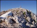
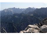
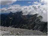
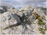
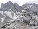
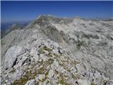
 | Sella Nevea - Visoki Kanin (Via ferrata Divisione Julia)
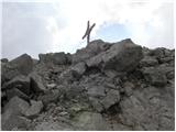
Visoki Kanin is the highest peak of the Kanin mountains. From the summit, which has a cross, there is a nice view of the western Julian Alps, and...
4 h 45 min |
 | Ravenska Kočna - Grintovec (past the cableway and on Frischaufova pot)
Grintovec is the highest peak of the Kamnik-Savinja Alps. It is located above the Kamniška Bistrica Valley, Suhi Dol, and the Ravenska Kočna Vall...
5 h 15 min |
 | Ravenska Kočna - Grintovec (past the cableway and on Kremžarjeva pot)
Grintovec is the highest peak of the Kamnik-Savinja Alps. It is located above the Kamniška Bistrica Valley, Suhi Dol, and the Ravenska Kočna Vall...
5 h 15 min |
 | Koča na Gozdu - Prisank / Prisojnik (Hanzova pot)
Prisank (also known as Prisojnik) is a 2,547-meter-high mountain situated above the Mlinarica, Krnica, and Suha Pišnica valleys. From the summit,...
5 h |
 | Aljažev dom v Vratih - Triglavski dom na Kredarici (Tominšek route)
The Triglav Hut at Kredarica is the highest-lying serviced Slovenian mountain hut. It is open all year round but outside the season only on an em...
4 h 55 min |
| Aljažev dom v Vratih - Triglavski dom na Kredarici (via Prag)
The Triglav Hut at Kredarica is the highest-lying serviced Slovenian mountain hut. It is open all year round but outside the season only on an em...
5 h |
 | Ravenska Kočna - Jezerska Kočna (past the cableway and on Kremžarjeva pot)
Jezerska Kočna is located west of Grintovec. From the summit, there is a very nice view towards Grintovec. The Karawanks and the Gorenjska plain ...
5 h |
| Ravenska Kočna - Jezerska Kočna (umik Žrela and on Kremžarjeva pot)
Jezerska Kočna is located west of Grintovec. From the summit, there is a very nice view towards Grintovec. The Karawanks and the Gorenjska plain ...
5 h 5 min |
| Ravenska Kočna - Jezerska Kočna (via Štularjeva planina and on path Kremžarjeva pot)
Jezerska Kočna is located west of Grintovec. From the summit, there is a very nice view towards Grintovec. The Karawanks and the Gorenjska plain ...
5 h |
 | Ravenska Kočna - Dolgi hrbet (past the cableway and on Frischaufova pot)
Dolgi Hrbet lies between Grintovec and Skuta. From its precipitous summit there is a fine view across the heart of the Kamnik-Savinja Alps. Dolgi...
5 h |
 | Ravenska Kočna - Dolgi hrbet (umik Žrela and on Frischaufova pot)
Dolgi Hrbet lies between Grintovec and Skuta. From its precipitous summit there is a fine view across the heart of the Kamnik-Savinja Alps. Dolgi...
5 h 5 min |
| Ravenska Kočna - Dolgi hrbet (via Štularjeva planina and on path Frischaufova pot)
Dolgi Hrbet lies between Grintovec and Skuta. From its precipitous summit there is a fine view across the heart of the Kamnik-Savinja Alps. Dolgi...
5 h |
 | Ruski križ - Špik (via Koča v Krnici)
Špik is a 2,472 m high mountain situated in the heart of the Martuljek group. From the summit, clearly visible from the road through Gozd Martulj...
4 h 50 min |
 | Aljažev dom v Vratih - Begunjski vrh (via Prag)
Begunjski Vrh is a 2,461 m high mountain located in the heart of the highest peaks of the Julian Alps. From the summit, which has a registration ...
5 h |
| Aljažev dom v Vratih - Begunjski vrh (Tominšek route)
Begunjski Vrh is a 2,461 m high mountain located in the heart of the highest peaks of the Julian Alps. From the summit, which has a registration ...
4 h 55 min |
 | Ravenska Kočna - Kranjska Rinka (Slovenska pot)
Kranjska Rinka is the highest of all the Rinka peaks. From the summit, which has a logbook, the most beautiful view is towards Skuta. The other R...
4 h 35 min |
| Ravenska Kočna - Kranjska Rinka (via Žrelo)
Kranjska Rinka is the highest of all the Rinka peaks. From the summit, which has a logbook, the most beautiful view is towards Skuta. The other R...
4 h 35 min |
| Ravenska Kočna - Kranjska Rinka (hunting path)
Kranjska Rinka is the highest of all the Rinka peaks. From the summit, which has a logbook, the most beautiful view is towards Skuta. The other R...
4 h 50 min |
 | Trate / Johannsenruhe - Hochstuhl/Stol (climbing way)
Stol is, at 2,236 m, the highest peak in the Karawanks. From the summit, which has a registration box and stamp, a beautiful view opens onto the ...
3 h 20 min |
 | Vranček - Veliki vrh (Košuta) (climbing way)
Veliki Vrh, at 2,088 m, is the westernmost two-thousander in Slovenia's longest ridge, the Košuta. From the summit, which has a registration box ...
3 h 10 min |
| Ljubelj - Veliki vrh (Košuta) (via Koča na Ljubelju)
Veliki Vrh, at 2,088 m, is the westernmost two-thousander in Slovenia's longest ridge, the Košuta. From the summit, which has a registration box ...
3 h 50 min |
| Bučan - Veliki vrh (Košuta)
Veliki Vrh, at 2,088 m, is the westernmost two-thousander in Slovenia's longest ridge, the Košuta. From the summit, which has a registration box ...
3 h 50 min |
 | Dom pod Storžičem - Storžič (via Psica)
Storžič is a 2132 m high mountain located in the western part of the Kamnik-Savinja Alps. From the summit, where there is a cross, a beautiful vi...
3 h 45 min |
| Gozd - Storžič (via Psica)
Storžič is a 2132 m high mountain located in the western part of the Kamnik-Savinja Alps. From the summit, where there is a cross, a beautiful vi...
4 h 50 min |
 | NC Planica - Visoka Ponca
Visoka Ponca lies on the border with Italy and offers a beautiful view of the mountains above the Tamar valley and the Italian Julian Alps. From ...
4 h 45 min |
| Belopeška jezera - Visoka Ponca (via normale)
Visoka Ponca lies on the border with Italy and offers a beautiful view of the mountains above the Tamar valley and the Italian Julian Alps. From ...
4 h |
 | Belopeška jezera - Visoka Ponca (ferrata)
Visoka Ponca lies on the border with Italy and offers a beautiful view of the mountains above the Tamar valley and the Italian Julian Alps. From ...
4 h |
 | Dom Planincev v Logarski dolini - Ojstrica (Kopinškova pot)
Ojstrica, named for its sharp shape, rises steeply above Korošica, the Logarska Dolina valley, and Robanov Kot. From the summit, which has a regi...
4 h 5 min |
 | Ruski križ - Pogačnikov dom na Kriških podih (via Kriška stena)
The hut is located on the scenic ridge Griva on Kriški Podi above Trenta. The hut, open during the summer season, also has a large winter room. T...
5 h 30 min |
 | NC Planica - Mala Mojstrovka (via Grlo)
Mala Mojstrovka is one of the most visited peaks in the Julian Alps due to the relatively high elevation of its starting point. From the summit, ...
4 h 35 min |
 | Ruski križ - Križ
Križ is a 2,140 m high mountain located northeast of the Kriški Podi plateau. The summit, which has a registration box with a stamp, offers a bea...
4 h 45 min |
 | V Koncu - Kalški greben
Kalški greben is a 2224 m high peak and the highest point of the ridge bearing the same name. From the summit, where there is a summit register a...
4 h |
| Suhadolnik - Kalški greben
Kalški greben is a 2224 m high peak and the highest point of the ridge bearing the same name. From the summit, where there is a summit register a...
4 h 15 min |
 | Aljažev dom v Vratih - Visoka Vrbanova špica (via Prag)
Visoka Vrbanova špica is located at the far southwestern end of the ridge rising above the Kot and Vrata valleys, and higher up between the Kot a...
4 h 50 min |
| Aljažev dom v Vratih - Visoka Vrbanova špica (Tominšek route)
Visoka Vrbanova špica is located at the far southwestern end of the ridge rising above the Kot and Vrata valleys, and higher up between the Kot a...
4 h 45 min |
 | Sele pri Cerkvi / Zell - Pfarre - Koschutnikturm (Košutnikov turn) (ÖTK Steig Neu)
Košutnikov Turn is the highest peak in Košuta, the longest Slovenian ridge. The summit offers a beautiful view of the entire ridge. Austria and t...
4 h |
| Ridovc / Ridovcsäge - Koschutnikturm (Košutnikov turn) (along Mrzlem potok and via ÖTK Steig Neu)
Košutnikov Turn is the highest peak in Košuta, the longest Slovenian ridge. The summit offers a beautiful view of the entire ridge. Austria and t...
4 h 10 min |
 | Ravenska Kočna - Ledinski vrh (Slovenian way)
The mountain is located above Jezersko and lies on the border with Austria. From the summit there is a beautiful view north towards the neighbour...
3 h 15 min |
| Ravenska Kočna - Ledinski vrh (via Žrelo)
The mountain is located above Jezersko and lies on the border with Austria. From the summit there is a beautiful view north towards the neighbour...
3 h 15 min |
 | Baumgartnerhof - Kresišče (climbing way)
Kresišče is an 1839 m high peak in the main ridge of the Karawanks, specifically between Kepa and Trupejevo poldne. From the summit, where a wood...
3 h 15 min |
 | Ravenska Kočna - Koroška Rinka (Slovenska pot)
Koroška Rinka (also known as Križ) is a 2433 m high mountain rising steeply above Ledine and Okrešelj. The summit has a register and stamp, offer...
4 h 15 min |
| Belska Kočna - Koroška Rinka
Koroška Rinka (also known as Križ) is a 2433 m high mountain rising steeply above Ledine and Okrešelj. The summit has a register and stamp, offer...
4 h 45 min |
| Ravenska Kočna - Koroška Rinka (via Žrelo)
Koroška Rinka (also known as Križ) is a 2433 m high mountain rising steeply above Ledine and Okrešelj. The summit has a register and stamp, offer...
4 h 15 min |
| Ravenska Kočna - Koroška Rinka (hunting path)
Koroška Rinka (also known as Križ) is a 2433 m high mountain rising steeply above Ledine and Okrešelj. The summit has a register and stamp, offer...
4 h 30 min |
 | Ravenska Kočna - Štajerska Rinka (Slovenska pot)
Štajerska Rinka is a 2374 m high mountain rising steeply above Okrešelj, more precisely east of the more visited Koroška Rinka. The summit has a ...
4 h 30 min |
| Ravenska Kočna - Štajerska Rinka (via Žrelo)
Štajerska Rinka is a 2374 m high mountain rising steeply above Okrešelj, more precisely east of the more visited Koroška Rinka. The summit has a ...
4 h 30 min |
| Ravenska Kočna - Štajerska Rinka (hunting path)
Štajerska Rinka is a 2374 m high mountain rising steeply above Okrešelj, more precisely east of the more visited Koroška Rinka. The summit has a ...
4 h 45 min |
 | Jermanca - Turska gora (via Kamniško sedlo)
The mountain is located above Logarska dolina and the Kamniška Bistrica valley. From the summit, there is a beautiful view of the neighboring pea...
4 h 45 min |
 | Baumgartnerhof - Mallestiger Mittagskogel (climbing way)
Ostra peč, known in German as Mallestiger Mittagskogel, is an 1801 m high mountain located on the northern side of the main Karawanks ridge. From...
3 h 15 min |
 | Planina Zajzera - Cima Alta (Due Pizzi) (path 648)
Dve špici (Due Pizzi) comprise two peaks in the Naborjet mountains group, namely Cima Alta (2046 m) and Cima Vildiver (2008 m). Both peaks have a...
4 h |
 | Rudnik v Topli - Petzen (Kordeschkopf) (Peca (Kordeževa glava)) (via Dom na Peci - climbing way)
Kordeževa glava, better known as Peca, is the highest peak of the Peca range. It is located on the border with Austria above the Mežiška dolina v...
3 h 30 min |
| Podpeca (Mitnek) - Petzen (Kordeschkopf) (Peca (Kordeževa glava)) (climbing way)
Kordeževa glava, better known as Peca, is the highest peak of the Peca range. It is located on the border with Austria above the Mežiška dolina v...
4 h 15 min |
| Koča na Pikovem - Petzen (Kordeschkopf) (Peca (Kordeževa glava)) (over saddle Vrh šteng and on climbing way)
Kordeževa glava, better known as Peca, is the highest peak of the Peca range. It is located on the border with Austria above the Mežiška dolina v...
3 h 45 min |
| Topla (Burjak) - Petzen (Kordeschkopf) (Peca (Kordeževa glava)) (over Mala Peca and on climbing way)
Kordeževa glava, better known as Peca, is the highest peak of the Peca range. It is located on the border with Austria above the Mežiška dolina v...
4 h |
 | Ravenska Kočna - Velika (Koroška) Baba (on Slovenska and climbing way)
Velika (Koroška) Baba is a 2127 m high mountain on the border ridge above the Ravenska Kočna valley on the Slovenian side and above the Bela (Bel...
3 h 45 min |
| Ravenska Kočna - Velika (Koroška) Baba (on Slovenska pot and over Jezersko sedlo)
Velika (Koroška) Baba is a 2127 m high mountain on the border ridge above the Ravenska Kočna valley on the Slovenian side and above the Bela (Bel...
4 h 15 min |
| Ravenska Kočna - Velika (Koroška) Baba (through Žrelo and on climbing way)
Velika (Koroška) Baba is a 2127 m high mountain on the border ridge above the Ravenska Kočna valley on the Slovenian side and above the Bela (Bel...
3 h 45 min |
| Ravenska Kočna - Velika (Koroška) Baba (on hunting and climbing path)
Velika (Koroška) Baba is a 2127 m high mountain on the border ridge above the Ravenska Kočna valley on the Slovenian side and above the Bela (Bel...
4 h |
| Ravenska Kočna - Velika (Koroška) Baba (through Žrelo and over Jezersko sedlo)
Velika (Koroška) Baba is a 2127 m high mountain on the border ridge above the Ravenska Kočna valley on the Slovenian side and above the Bela (Bel...
4 h 15 min |
 | Zadnja Trenta (Flori) - Bavški Grintavec (via Kanski preval)
Bavški Grintavec is a mighty mountain that rises steeply above the valleys of Bavšica, Zadnja Trenta, and Soča. All approaches to the summit are ...
4 h 45 min |
| Zadnja Trenta (Flori) - Bavški Grintavec (direct way)
Bavški Grintavec is a mighty mountain that rises steeply above the valleys of Bavšica, Zadnja Trenta, and Soča. All approaches to the summit are ...
4 h 30 min |
 | The Kot Valley - Spodnja Vrbanova špica (via Lojze Rekar)
Spodnja Vrbanova špica is a 2,299 m high mountain above Kot valley and Za Cmirom valley. From the summit there is a very nice view toward Rjavina...
4 h |
 | Planina Kuk - Vrh nad Škrbino (via Škrbina)
Vrh nad Škrbino is the easternmost two-thousander in the ridge of the Lower Bohinj Mountains. From the summit, there are excellent views of the n...
3 h 45 min |
| Tolminske Ravne - Vrh nad Škrbino (on steep pathi and over Škrbina)
Vrh nad Škrbino is the easternmost two-thousander in the ridge of the Lower Bohinj Mountains. From the summit, there are excellent views of the n...
4 h |
 | Reißkofelbad - Reißkofel (via bivouac)
Reißkofel is a 2371 m high mountain in the Gailtal Alps. The summit, marked by a cross, also features a summit register. The view is particularly...
4 h 30 min |
 | Belopeška jezera - Srednja Ponca / Ponza di Mezze
Srednja Ponca is a 2,228-meter-high peak rising steeply above Tamar, Planica, and Mangartska Dolina. From the summit, which has a stamp, there ar...
3 h 45 min |
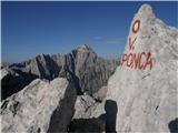
 | NC Planica - Zadnja Ponca / Ponza di Detro
Zadnja Ponca is a 2,242-meter-high peak located on the narrow and precipitous Ponca ridge. From the summit, which is not accessible to everyone, ...
4 h 50 min |
| Belopeška jezera - Zadnja Ponca / Ponza di Detro
Zadnja Ponca is a 2,242-meter-high peak located on the narrow and precipitous Ponca ridge. From the summit, which is not accessible to everyone, ...
4 h 30 min |
 | Velacher Kotschna/Belska Kočna - Vellacher Turm/Storžek
Storžek (or Belski turn) is a 2,110-meter-high mountain on the Austrian side of Jezersko sedlo. The summit, which is not marked on most Slovenian...
3 h 15 min |
| Ravenska Kočna - Vellacher Turm/Storžek (Slovenska pot)
Storžek (or Belski turn) is a 2,110-meter-high mountain on the Austrian side of Jezersko sedlo. The summit, which is not marked on most Slovenian...
4 h |
| Ravenska Kočna - Vellacher Turm/Storžek (via Žrelo)
Storžek (or Belski turn) is a 2,110-meter-high mountain on the Austrian side of Jezersko sedlo. The summit, which is not marked on most Slovenian...
4 h |
| Ravenska Kočna - Vellacher Turm/Storžek (hunting path)
Storžek (or Belski turn) is a 2,110-meter-high mountain on the Austrian side of Jezersko sedlo. The summit, which is not marked on most Slovenian...
4 h 15 min |
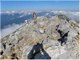
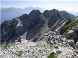
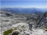
 | Sella Nevea - Vrh Krnice
Vrh Krnice is a 2,441-meter-high peak located northwest of Visoki Kanin. From the summit, where there is usually an empty logbook box, there is a...
5 h 15 min |
 | Zajzera - Monte Nabois grande (variante per la crestaest)
Veliki Nabojs, or Monte Nabois grande in Italian, is a 2313 m high mountain located north of the higher and better-known Viš. From the summit, wh...
4 h 30 min |
| Zajzera - Monte Nabois grande
Veliki Nabojs, or Monte Nabois grande in Italian, is a 2313 m high mountain located north of the higher and better-known Viš. From the summit, wh...
4 h 30 min |
 | Klammbrückl - Weittalspitze (Allmaier Toni Weg)
Weittalspitze is a 2539-meter-high peak in the Lienz Dolomites. The summit is located south of the Kerschbaumeralm pasture. From the top, where a...
4 h 30 min |
 | Rifugio Cercena - Cima Montanel
Cima Montanel is a 2,461-meter-high peak above the Piave river valley in the Carnic Prealps. The summit, which bears a cross, is an exceptional v...
4 h 40 min |
| Rifugio Padova - Cima Montanel (via Forcella di Crodon)
Cima Montanel is a 2,461-meter-high peak above the Piave river valley in the Carnic Prealps. The summit, which bears a cross, is an exceptional v...
4 h 50 min |
 | Aljažev dom v Vratih - Kredarica (via Prag)
Kredarica is a 2,541-meter-high panoramic peak located between Triglav and Rž. From the summit, a nice view opens up towards Triglav and the surr...
5 h 5 min |
| Aljažev dom v Vratih - Kredarica (Tominšek route)
Kredarica is a 2,541-meter-high panoramic peak located between Triglav and Rž. From the summit, a nice view opens up towards Triglav and the surr...
5 h |
 | Edelweiss - Monte Volaia / Wolayer Kopf (path 176)
Italian Monte Volaia, German Wolayer Kopf, is a 2470-meter-high peak in the main ridge of the Carnic Alps west of the highest peak Monte Coglians...
3 h 45 min |
| Collina - Monte Volaia / Wolayer Kopf (path 141)
Italian Monte Volaia, German Wolayer Kopf, is a 2470-meter-high peak in the main ridge of the Carnic Alps west of the highest peak Monte Coglians...
4 h |
 | Val Aupa - Creta Grauzaria (via normale)
Creta Grauzaria (Friulian: La Crete) is a 2,065-meter-high mountain in the Carnic Alps in Italy. The first ascent occurred on June 18, 1893, due ...
4 h 20 min |
 | Planina Zajzera - Monte Gosadon
Monte Gosadon is a somewhat less-visited peak in the Naborjet Mountains group. The surroundings of the peak also feature quite a few remains from...
4 h 10 min |
 | Gozdec - Vrh Laške Planje
Vrh Laške Planje (Lasca Plagna) is a 2,448-meter-high peak located on the border ridge between Italy and Slovenia. From the top there is a magnif...
5 h |
 | Coot Parking Lot - Vrh Laške Planje
Vrh Laške Planje (Lasca Plagna) is a 2,448-meter-high peak located on the border ridge between Italy and Slovenia. From the top there is a magnif...
5 h 45 min |
 | Planina Zajzera - Visoki Pipar / Monte Piper
Visoki Pipar or Italian Monte Piper is, with 2069 meters, the highest and most easily accessible peak in the Pipar ridge in the Naborje mountains...
3 h 40 min |
 | Gozdec - Črni Vogel
Črni Vogel (Italian: Cerni Vogu) is a 2,422-meter-high peak located in the Kanin Mountains on the border between Italy and Slovenia. The Visoka R...
5 h 30 min |
 | Karnica / Sella Carnizza - Monte Musi (western peak)
Vrh Muzcev (western peak) is located in the central part of the Muzcev Ridge, separating Rezija Valley and Terska Valley. Its 1,864-meter summit,...
3 h 30 min |
 | Coot Parking Lot - Vrh Žlebi / Monte Slebe
Vrh Žlebi (also known as Žbrančev zob, Italian: Monte Slebe) lies in the Kanin Mountains on the border between Italy and Slovenia, east of the Žl...
4 h 45 min |