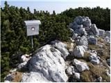
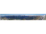
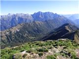
 | Sella Nevea - Prestreljenik (on ski track)
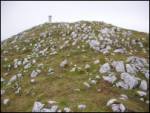
Prestreljenik is a 2,499 m high mountain located in the heart of the Kanin range. From the summit, where there is a registration box shaped like ...
3 h 30 min |
 | Podljubelj (Lajb) - Begunjščica
Begunjščica is a mountain range in the Karawanks east of Stol. Its highest peak is Veliki Vrh, which at over 2,000 m offers a fine view across ce...
3 h 30 min |
 | Ljubelj - Begunjščica (via Zelenica)
Begunjščica is a mountain range in the Karawanks east of Stol. Its highest peak is Veliki Vrh, which at over 2,000 m offers a fine view across ce...
3 h 50 min |
| Tinčkova koča - Begunjščica
Begunjščica is a mountain range in the Karawanks east of Stol. Its highest peak is Veliki Vrh, which at over 2,000 m offers a fine view across ce...
3 h 15 min |
 | Dom v Dragi - Begunjščica (via Preval-a)
Begunjščica is a mountain range in the Karawanks east of Stol. Its highest peak is Veliki Vrh, which at over 2,000 m offers a fine view across ce...
3 h 30 min |
 | Tinčkova koča - Begunjščica (via Poljška planina)
Begunjščica is a mountain range in the Karawanks east of Stol. Its highest peak is Veliki Vrh, which at over 2,000 m offers a fine view across ce...
3 h 50 min |
 | Ljubelj - Hochstuhl/Stol (upper way)
Stol is, at 2,236 m, the highest peak in the Karawanks. From the summit, which has a registration box and stamp, a beautiful view opens onto the ...
4 h 50 min |
| Johannsenruhe - Hochstuhl/Stol (via Klagenfurter Hütte)
Stol is, at 2,236 m, the highest peak in the Karawanks. From the summit, which has a registration box and stamp, a beautiful view opens onto the ...
3 h 45 min |
| Ljubelj - Hochstuhl/Stol (via Vatelca or Skleda)
Stol is, at 2,236 m, the highest peak in the Karawanks. From the summit, which has a registration box and stamp, a beautiful view opens onto the ...
5 h |
 | Vranček - Loibler Baba/Košutica (western way)
Košutica (also known as Ljubeljska Baba) is a panoramic mountain north of the western ridge of Košuta. From the summit, marked by a small cross a...
2 h 50 min |
 | Sele-Zvrhnji Kot (Male) / Zell-Oberwinkel (Male) - Loibler Baba/Košutica (over Dovjakovo sedlo)
Košutica (also known as Ljubeljska Baba) is a panoramic mountain north of the western ridge of Košuta. From the summit, marked by a small cross a...
4 h 45 min |
 | Uskovnica (Lom) - Viševnik (via Srenjski preval)
Viševnik is a 2050 m high mountain rising northwest of Rudno polje on Pokljuka. From the summit, where there is a stamp, a beautiful view opens o...
3 h 10 min |
 | Ljubelj - Vertatscha/Vrtača
Vrtača is a 2181 m high peak located east of Stol. From the summit, where a large peg stands, a beautiful view opens over parts of the Julian Alp...
3 h 30 min |
| Tinčkova koča - Vertatscha/Vrtača (via Smuška planina in saddle Šija)
Vrtača is a 2181 m high peak located east of Stol. From the summit, where a large peg stands, a beautiful view opens over parts of the Julian Alp...
3 h 30 min |
| Trate / Johannsenruhe - Vertatscha/Vrtača
Vrtača is a 2181 m high peak located east of Stol. From the summit, where a large peg stands, a beautiful view opens over parts of the Julian Alp...
4 h |
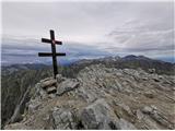
 | Gozd - Storžič (through southwest groove)
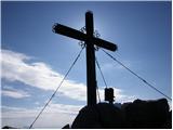
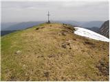
Storžič is a 2132 m high mountain located in the western part of the Kamnik-Savinja Alps. From the summit, where there is a cross, a beautiful vi...
4 h 55 min |
 | Planina Kuhinja - Krn (via jezero v Lužnici)
Krn, at 2244 m, is the highest peak of the Krn mountain group, which rises steeply above the central part of the Soča River. From the summit, fea...
4 h 45 min |
 | Planina Kuk - Tolminski Kuk
Tolminski Kuk is the highest peak in the Bohinj-Tolmin mountains. The summit, equipped with a registration box, offers a very beautiful view. Fro...
4 h 30 min |
 | Tolminske Ravne - Tolminski Kuk (via Dolina pod Ploščo)
Tolminski Kuk is the highest peak in the Bohinj-Tolmin mountains. The summit, equipped with a registration box, offers a very beautiful view. Fro...
4 h 35 min |
 | Aljažev dom v Vratih - Pogačnikov dom na Kriških podih (via Sovatna)
The hut is located on the scenic ridge Griva on Kriški Podi above Trenta. The hut, open during the summer season, also has a large winter room. T...
4 h 30 min |
 | Aljažev dom v Vratih - Križ (via bivak na Rušju)
Križ is a 2,140 m high mountain located northeast of the Kriški Podi plateau. The summit, which has a registration box with a stamp, offers a bea...
4 h 30 min |
 | Ljubelj - Prešernova koča na Stolu (upper way)
The Prešernova koča na Stolu mountain hut is located just a few metres below the summit of the 2198 m high Mali Stol. From the hut or the nearby ...
4 h 45 min |
| Ljubelj - Prešernova koča na Stolu (via Vatelca or Skleda)
The Prešernova koča na Stolu mountain hut is located just a few metres below the summit of the 2198 m high Mali Stol. From the hut or the nearby ...
4 h 55 min |
 | Trate / Johannsenruhe - Prešernova koča na Stolu (via Celovška koča)
The Prešernova koča na Stolu mountain hut is located just a few metres below the summit of the 2198 m high Mali Stol. From the hut or the nearby ...
3 h 40 min |
 | Koča pri Savici - Bogatin (via Bogatinsko sedlo)
Bogatin, also known as Mali Bogatin, is the last or first peak in the chain of the Lower Bohinj Mountains. From the summit, where there is a summ...
4 h 30 min |
| Dom v Lepeni - Bogatin (via Bogatinsko sedlo)
Bogatin, also known as Mali Bogatin, is the last or first peak in the chain of the Lower Bohinj Mountains. From the summit, where there is a summ...
4 h 30 min |
 | Koča pri Savici - Mahavšček (via Bogatin)
Mahavšček, or Veliki Bogatin, is a 2008 m high mountain on the northwestern edge of the Lower Bohinj Mountains. From the summit, with its somewha...
5 h |
| Dom v Lepeni - Mahavšček (via Bogatinsko sedlo)
Mahavšček, or Veliki Bogatin, is a 2008 m high mountain on the northwestern edge of the Lower Bohinj Mountains. From the summit, with its somewha...
5 h |
 | Ravenska Kočna - Ledinski vrh (hunter's way)
The mountain is located above Jezersko and lies on the border with Austria. From the summit there is a beautiful view north towards the neighbour...
3 h 30 min |
| Koča pod slapom Rinka - Ledinski vrh
The mountain is located above Jezersko and lies on the border with Austria. From the summit there is a beautiful view north towards the neighbour...
3 h 30 min |
 | Velacher Kotschna/Belska Kočna - Ledinski vrh
The mountain is located above Jezersko and lies on the border with Austria. From the summit there is a beautiful view north towards the neighbour...
3 h 45 min |
 | Dolina - Kofce gora (past the chapel)
Kofce gora is a 1967 m high peak located in the eastern part of the longest Slovenian ridge. From the summit, which drops precipitously towards A...
2 h 50 min |
| Dolina - Kofce gora
Kofce gora is a 1967 m high peak located in the eastern part of the longest Slovenian ridge. From the summit, which drops precipitously towards A...
2 h 45 min |
 | Matizovec - Veliko Kladivo
Veliko Kladivo is a 2094 m high peak in the longest Slovenian ridge, Košuta. From the summit, which has a register box and stamp, there is a very...
3 h 20 min |
| Globoka dolina - Veliko Kladivo
Veliko Kladivo is a 2094 m high peak in the longest Slovenian ridge, Košuta. From the summit, which has a register box and stamp, there is a very...
3 h |
| Dolina - Veliko Kladivo
Veliko Kladivo is a 2094 m high peak in the longest Slovenian ridge, Košuta. From the summit, which has a register box and stamp, there is a very...
3 h 30 min |
| Dolina - Veliko Kladivo (past the chapel)
Veliko Kladivo is a 2094 m high peak in the longest Slovenian ridge, Košuta. From the summit, which has a register box and stamp, there is a very...
3 h 30 min |
 | Povlje - Mali Grintovec (via Bašeljski vrh)
Mali Grintovec is a panoramic mountain located east of Storžič. From the summit, which has a summit register box, stamp, and a pleasant bench, th...
4 h 35 min |
 | Laško - Mali Grintovec (via Sveti Lovrenc)
Mali Grintovec is a panoramic mountain located east of Storžič. From the summit, which has a summit register box, stamp, and a pleasant bench, th...
4 h 25 min |
| Povlje - Mali Grintovec
Mali Grintovec is a panoramic mountain located east of Storžič. From the summit, which has a summit register box, stamp, and a pleasant bench, th...
4 h 25 min |
 | Planina Kuhinja - Batognica
Batognica is a 2164 m high mountain that was the site of the so-called mine warfare during World War I. Remnants of the fighting between Italian ...
3 h 20 min |
| Dom v Lepeni - Batognica (via Krnska škrbina)
Batognica is a 2164 m high mountain that was the site of the so-called mine warfare during World War I. Remnants of the fighting between Italian ...
4 h 50 min |
 | Bele Vode - Jerebica
Jerebica is a mountain located on the border between Slovenia and Italy, between the Možnica and Jezerska valleys. From the summit, where there i...
3 h 30 min |
 | Markova raven - Košutna (marked way)
The summit is located between Kompotela and the mountain pasture Košutna. From the top, there is a beautiful view toward Krvavec and Kalški grebe...
2 h 50 min |
 | Koča pri Savici - Vrh Planje (via Kser)
The mountain is located between Tolminski Kuk and Mahavšček in the ridge of the Lower Bohinj Mountains. From the top, there is a nice view toward...
5 h 5 min |
 | Planina Blato - Mala Zelnarica (Za Kopico)
Mala Zelnarica is a 2310-meter-high peak situated between the Valley of the Triglav Lakes and the Za Kopico Valley. From the summit, which has a ...
4 h 15 min |
 | Matizovec - Malo Kladivo
Malo Kladivo is located in the Košuta ridge. From the summit, which has no registration box, there is a nice view toward the neighboring Veliko K...
3 h 5 min |
 | Tinčkova koča - Bielschitza/Svačica (via Smokuška planina)
Svačica is a less prominent peak in the main ridge of the Karawanks. It lies between Vrtača and Stol, slightly offset to the north. The summit, m...
3 h 30 min |
 | Ljubelj - Bielschitza/Svačica (upper path)
Svačica is a less prominent peak in the main ridge of the Karawanks. It lies between Vrtača and Stol, slightly offset to the north. The summit, m...
4 h 20 min |
| Ljubelj - Bielschitza/Svačica (via Vatelca or Skleda)
Svačica is a less prominent peak in the main ridge of the Karawanks. It lies between Vrtača and Stol, slightly offset to the north. The summit, m...
4 h |
| Bodenbauer - Bielschitza/Svačica (via Karweg)
Svačica is a less prominent peak in the main ridge of the Karawanks. It lies between Vrtača and Stol, slightly offset to the north. The summit, m...
3 h |
 | Planina Storeča raven - Vogel (po severozahodnih pobočjih Visokega Orlovega roba)
Many associate the name Vogel first with the Vogel ski resort near the eponymous peak. From the north, it is recognizable by its pyramidal shape,...
3 h 45 min |
 | Planina Storeča raven - Vogel (po zahodnih pobočjih smučišča Vogel)
Many associate the name Vogel first with the Vogel ski resort near the eponymous peak. From the north, it is recognizable by its pyramidal shape,...
3 h 45 min |
 | Žabnice/Camporosso in Valcanale - Kamniti lovec / Cima del Cacciatore
Kamniti lovec is a popular excursion point above Trbiž. Due to the short approach, shortened by the cable car to Višarje, it is well visited. Two...
3 h 15 min |
 | Koča pod slapom Rinka - Velika (Koroška) Baba
Velika (Koroška) Baba is a 2127 m high mountain on the border ridge above the Ravenska Kočna valley on the Slovenian side and above the Bela (Bel...
4 h 30 min |
| Ravenska Kočna - Velika (Koroška) Baba (on hunting path and over Jezersko sedlo)
Velika (Koroška) Baba is a 2127 m high mountain on the border ridge above the Ravenska Kočna valley on the Slovenian side and above the Bela (Bel...
4 h 30 min |
 | Gostišče Firšt - Govca (Olševa)
Govca is the highest peak of the Olševa range, rising above Koprivna, Solčava, and Remšenik (Remšenik/Remschenig is a valley on the Austrian side...
3 h 45 min |
 | Tolminske Ravne - Vrh nad Škrbino (on mule track and direct way)
Vrh nad Škrbino is the easternmost two-thousander in the ridge of the Lower Bohinj Mountains. From the summit, there are excellent views of the n...
4 h |
 | Weissensee - Eckwand (via Almspitz)
Eckwand (2,221 m) is a peak in the Latschur group. From its grassy summit, which features a cross, there are beautiful views of the Gailtal Alps,...
4 h 45 min |
 | Remšendol - Šober / Monte Sciober Grande (via 518)
Šober / Monte Sciober Grande is a 1,845 m high peak located between the Remšendol Valley and Jezerska Valley. From the summit there is a fine vie...
3 h |
 | Sele-Zvrhnji Kot (Male) / Zell-Oberwinkel (Male) - Lokovnikov Grintovec / Grintoutz
Lokovnikov Grintovec is a dwarf pine-covered peak north of Košutica, separated from it by Dovjakovo sedlo saddle (1,728 m). Its southwestern and ...
4 h |
 | Planina Kuk - Zeleni vrh
Zeleni vrh is a 2052-meter-high mountain located east of the highest peak of the Spodnje Bohinjske gore. From the grassy summit, which drops prec...
4 h 5 min |
 | Tolminske Ravne - Zeleni vrh (via Dolina pod Ploščo)
Zeleni vrh is a 2052-meter-high mountain located east of the highest peak of the Spodnje Bohinjske gore. From the grassy summit, which drops prec...
4 h 10 min |
 | Čadrg - Tolminski Migovec
Tolminski Migovec is a 1881 m high mountain. Its western slope above the Tolminka valley is the steepest and most scenic. The southern slope is i...
3 h 30 min |
 | Klammbrückl - Weittalspitze
Weittalspitze is a 2539-meter-high peak in the Lienz Dolomites. The summit is located south of the Kerschbaumeralm pasture. From the top, where a...
3 h 30 min |
 | Pala Barzana - Monte Raut (CAI 967)
Raut is a 2,025 m high limestone vantage point above the Friulian plain and the second-highest peak of the ridge between lakes Barcis and Selva. ...
3 h 45 min |
 | Kesselfall - Höhenburg
Höhenburg is a 2,108-metre mountain in the Glockner group of the High Tauern. It is located beside the Mooserboden reservoir. From the summit, wh...
3 h 50 min |
 | Weißenbach - Spitzegel / Negal (25d)
Spitzegel / Negal is a 2,119 m high mountain in the Gailtal Alps in Austria. The ridge with its highest peak Spitzegel / Nagal logically connects...
3 h 40 min |
 | Neustift im Stubaital - Hoher Burgstall (south path via Starkenburger Hütte)
Hoher Burgstall is one of the seven classic peaks of the Stubai Alps, recognized by locals as outstanding in historical, tourist, and aesthetic t...
4 h 15 min |
 | Tri studničky - Kriváň
Mount Kriváň is the first prominent peak of the High Tatras when viewed from the west and belongs to Tatra National Park. It rises above the Lipt...
4 h |
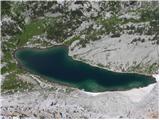
| Koča pod slapom Rinka - Skuta Glacier
Ledenik pod Skuto is today the largest glacier in Slovenia. Due to its location, it is in good condition and has been slightly expanding accordin...
4 h 10 min |
 | Planina Zajzera - Visoki Pipar / Monte Piper (path 648)
Visoki Pipar or Italian Monte Piper is, with 2069 meters, the highest and most easily accessible peak in the Pipar ridge in the Naborje mountains...
3 h |
 | parking lot Hoyer (Neuhofgraben) - Speikkogel (Gleinalpe)
Speikkogel lies northwest of Graz and, at 1988 m, is the second highest peak of the Gleinalpe.The European path E6 and the Austrian Central Alpin...
3 h 30 min |
 | parking lot Hoyer (Neuhofgraben) - Lenzmoarkogel (Gleinalpe)
Lenzmoarkogel is located northwest of Gradec and, at 1991 meters above sea level, is the highest peak of the Gleinalpe (Glinska planina).The thre...
3 h 45 min |
 | parking lot Hoyer (Neuhofgraben) - Lärchkogel (Gleinalpe) (via Speikkogel)
Lärchkogel is a 1,894-meter peak in the Gleinalpe massif with a cross and a small shelter beside it. From the summit, there are fine views of Spe...
4 h 15 min |
 | Passo Tanamea - Monte Zajavor
Zajavor (Italian: Monte Zajavor or Monte Zaiavor) is a 1,815-meter-high peak in the eastern, grassier part of the Muzci ridge. From the summit, w...
3 h |