 | Aljažev dom v Vratih - Dolkova špica (western way)
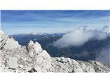
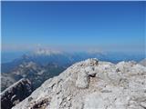
Dolkova špica is a 2,591 m high mountain situated between Stenar and Škrlatica. From the summit, which has a registration box, a beautiful panora...
5 h 15 min |
| Zadnjica - Dolkova špica
Dolkova špica is a 2,591 m high mountain situated between Stenar and Škrlatica. From the summit, which has a registration box, a beautiful panora...
7 h 5 min |
 | Zadnjica - Kanjavec (via Dolič)
Kanjavec is a 2,569-meter-high mountain located between Dolič and Hribarice. From the summit, which has a logbook box and a stamp, a beautiful vi...
6 h 35 min |
 | Koča pri Savici - Kanjavec (via Triglavska jezera)
Kanjavec is a 2,569-meter-high mountain located between Dolič and Hribarice. From the summit, which has a logbook box and a stamp, a beautiful vi...
6 h 30 min |
| Aljažev dom v Vratih - Kanjavec
Kanjavec is a 2,569-meter-high mountain located between Dolič and Hribarice. From the summit, which has a logbook box and a stamp, a beautiful vi...
7 h |
 | Suhadolnik - Grintovec (via Streha)
Grintovec is the highest peak of the Kamnik-Savinja Alps. It is located above the Kamniška Bistrica Valley, Suhi Dol, and the Ravenska Kočna Vall...
4 h 45 min |
 | The Kot Valley - Triglavski dom na Kredarici
The Triglav Hut at Kredarica is the highest-lying serviced Slovenian mountain hut. It is open all year round but outside the season only on an em...
5 h 10 min |
 | Zadnjica - Triglavski dom na Kredarici
The Triglav Hut at Kredarica is the highest-lying serviced Slovenian mountain hut. It is open all year round but outside the season only on an em...
7 h 30 min |
 | V Koncu - Skuta (via Kokrsko sedlo)
Skuta is a 2,532-meter-high mountain located in the heart of the Kamnik-Savinja Alps. From the summit, which has a logbook box and a stamp, a bea...
5 h 30 min |
| Suhadolnik - Skuta (via Kokrsko sedlo)
Skuta is a 2,532-meter-high mountain located in the heart of the Kamnik-Savinja Alps. From the summit, which has a logbook box and a stamp, a bea...
5 h 45 min |
 | B station - Prestreljenik (via Krnica)
Prestreljenik is a 2,499 m high mountain located in the heart of the Kanin range. From the summit, where there is a registration box shaped like ...
4 h 25 min |
 | Pišnica - Špik (via Kačji graben)
Špik is a 2,472 m high mountain situated in the heart of the Martuljek group. From the summit, clearly visible from the road through Gozd Martulj...
4 h 40 min |
 | The Kot Valley - Begunjski vrh
Begunjski Vrh is a 2,461 m high mountain located in the heart of the highest peaks of the Julian Alps. From the summit, which has a registration ...
4 h 40 min |
 | Jermanca - Planjava (via Kamniško sedlo)
Planjava is a smaller mountain group east of Kamniško sedlo. It has two peaks eastern and western. The marked path leads to the eastern peak, wh...
4 h 30 min |
| Pred Belo - Planjava
Planjava is a smaller mountain group east of Kamniško sedlo. It has two peaks eastern and western. The marked path leads to the eastern peak, wh...
7 h |
 | Na Razpotju - Planjava
Planjava is a smaller mountain group east of Kamniško sedlo. It has two peaks eastern and western. The marked path leads to the eastern peak, wh...
5 h |
| Dom Planincev v Logarski dolini - Planjava
Planjava is a smaller mountain group east of Kamniško sedlo. It has two peaks eastern and western. The marked path leads to the eastern peak, wh...
4 h 55 min |
 | Laško - Storžič (via Sveti Lovrenc and over Bašeljski preval)
Storžič is a 2132 m high mountain located in the western part of the Kamnik-Savinja Alps. From the summit, where there is a cross, a beautiful vi...
4 h 25 min |
| Bašelj - Storžič (via Sveti Lovrenc and over Bašeljski preval)
Storžič is a 2132 m high mountain located in the western part of the Kamnik-Savinja Alps. From the summit, where there is a cross, a beautiful vi...
5 h 5 min |
 | Dom v Kamniški Bistrici - Brana
Brana is a mountain above Kamniško sedlo. From the spacious summit, which has a registration box and a small cross, there is a very beautiful vie...
5 h |
 | Podrožca / Rosenbach - Mittagskogel/Kepa
Kepa (also Jepa, German: Mittagskogel) is a panoramic mountain in the western Karavanke, located on the border ridge between Slovenia and Austria...
5 h 10 min |
| Čemernica / Tschemernitzen - Mittagskogel/Kepa
Kepa (also Jepa, German: Mittagskogel) is a panoramic mountain in the western Karavanke, located on the border ridge between Slovenia and Austria...
5 h 5 min |
 | Pred Belo - Ojstrica
Ojstrica, named for its sharp shape, rises steeply above Korošica, the Logarska Dolina valley, and Robanov Kot. From the summit, which has a regi...
6 h 45 min |
 | Robanov kot - Ojstrica (via Mala Ojstrica)
Ojstrica, named for its sharp shape, rises steeply above Korošica, the Logarska Dolina valley, and Robanov Kot. From the summit, which has a regi...
5 h 15 min |
 | Pred Belo - Ojstrica
Ojstrica, named for its sharp shape, rises steeply above Korošica, the Logarska Dolina valley, and Robanov Kot. From the summit, which has a regi...
6 h 45 min |
| Robanov kot - Ojstrica (via Kocbekov dom)
Ojstrica, named for its sharp shape, rises steeply above Korošica, the Logarska Dolina valley, and Robanov Kot. From the summit, which has a regi...
5 h 45 min |
 | Tolminske Ravne - Krn
Krn, at 2244 m, is the highest peak of the Krn mountain group, which rises steeply above the central part of the Soča River. From the summit, fea...
7 h 30 min |
 | The Kot Valley - Cmir
Cmir is located between two alpine valleys: Vrata and the lesser-known valley Za Cmirom. From the summit, there is a beautiful view of the peaks ...
6 h 10 min |
| Dolina Krma - Cmir
Cmir is located between two alpine valleys: Vrata and the lesser-known valley Za Cmirom. From the summit, there is a beautiful view of the peaks ...
7 h 15 min |
 | Aljažev dom v Vratih - Križ (via Sovatna)
Križ is a 2,140 m high mountain located northeast of the Kriški Podi plateau. The summit, which has a registration box with a stamp, offers a bea...
5 h |
| Zadnjica - Križ (via Dovška vrata)
Križ is a 2,140 m high mountain located northeast of the Kriški Podi plateau. The summit, which has a registration box with a stamp, offers a bea...
5 h 45 min |
 | The Kot Valley - Visoka Vrbanova špica (via Staničev dom)
Visoka Vrbanova špica is located at the far southwestern end of the ridge rising above the Kot and Vrata valleys, and higher up between the Kot a...
4 h 30 min |
 | Tolminske Ravne - Batognica
Batognica is a 2164 m high mountain that was the site of the so-called mine warfare during World War I. Remnants of the fighting between Italian ...
6 h 45 min |
 | Zavrzelno - Rombon
Rombon is a scenic mountain above Bovec. It is particularly known for having the most artificial tunnels in Slovenia. During the First World War,...
4 h 45 min |
 | Možnica - Jerebica
Jerebica is a mountain located on the border between Slovenia and Italy, between the Možnica and Jezerska valleys. From the summit, where there i...
5 h |
 | Zadnjica - Planja
The Planja summit is located between two alpine valleys: Mlinarica on the north side and Zadnjica on the south. From the summit, there is a beaut...
5 h 45 min |
| Aljažev dom v Vratih - Planja (via Sovatna)
The Planja summit is located between two alpine valleys: Mlinarica on the north side and Zadnjica on the south. From the summit, there is a beaut...
6 h 5 min |
 | Koča pri Savici - Veliko Špičje
Veliko Špičje is the highest peak in the ridge from Travnik to Zasavska koča. From the top, there is a very nice view of the Komna plateaus, the ...
5 h 40 min |
| Koča pri Savici - Veliko Špičje (via Zasavska koča)
Veliko Špičje is the highest peak in the ridge from Travnik to Zasavska koča. From the top, there is a very nice view of the Komna plateaus, the ...
7 h 15 min |
| Zadnjica - Veliko Špičje
Veliko Špičje is the highest peak in the ridge from Travnik to Zasavska koča. From the top, there is a very nice view of the Komna plateaus, the ...
6 h 20 min |
| Trenta - Veliko Špičje
Veliko Špičje is the highest peak in the ridge from Travnik to Zasavska koča. From the top, there is a very nice view of the Komna plateaus, the ...
6 h 30 min |
 | Koča pri Savici - Mala Zelnarica (via Štapce)
Mala Zelnarica is a 2310-meter-high peak situated between the Valley of the Triglav Lakes and the Za Kopico Valley. From the summit, which has a ...
5 h 55 min |
 | Koča pri Savici - Mala Zelnarica (via Vrata)
Mala Zelnarica is a 2310-meter-high peak situated between the Valley of the Triglav Lakes and the Za Kopico Valley. From the summit, which has a ...
6 h 40 min |
 | Aljažev dom v Vratih - Bovški Gamsovec (via Sovatna)
Bovški Gamsovec is a 2392 m high mountain in the immediate vicinity of Triglav. From the summit there is a magnificent view of Triglav and its no...
4 h 45 min |
| Zadnjica - Bovški Gamsovec (via Luknja)
Bovški Gamsovec is a 2392 m high mountain in the immediate vicinity of Triglav. From the summit there is a magnificent view of Triglav and its no...
5 h 15 min |
| Zadnjica - Bovški Gamsovec (via Dovška vrata)
Bovški Gamsovec is a 2392 m high mountain in the immediate vicinity of Triglav. From the summit there is a magnificent view of Triglav and its no...
5 h 30 min |
 | Reißkofelbad - Reißkofel (via east ridge)
Reißkofel is a 2371 m high mountain in the Gailtal Alps. The summit, marked by a cross, also features a summit register. The view is particularly...
4 h 45 min |
 | Reklanska dolina - Sart / Žrd
Žrd, or Monte Sart in Italian, is a panoramic mountain located on the northwestern ridge of the Kanin mountains. The summit, which has a logbook ...
5 h 15 min |
 | Solbica / Stolvizza - Sart / Žrd (via Ricovero Igor Crasso)
Žrd, or Monte Sart in Italian, is a panoramic mountain located on the northwestern ridge of the Kanin mountains. The summit, which has a logbook ...
6 h |
 | Aljažev dom v Vratih - Pihavec (via Sovatna)
Pihavec is a spacious and panoramic peak located south of Kriški Podi. From the summit, which has a logbook and stamp, there are nice views of mo...
5 h 15 min |
| Zadnjica - Pihavec
Pihavec is a spacious and panoramic peak located south of Kriški Podi. From the summit, which has a logbook and stamp, there are nice views of mo...
5 h 15 min |
 | Unterpirkach - Hochstadel (Dreitörlweg)
Hochstadel is a 2,681-meter peak in the eastern part of the picturesque Lienz Dolomites. From the summit, where a large cross commemorates those ...
6 h 50 min |
 | Bachwinkl - Großer Hundstod
Großer Hundstod is a 2594-meter-high peak in the Berchtesgaden Alps on the border between Austria and Germany. Hundstod is also the highest peak ...
7 h 30 min |
 | Hinterstoder - Großer Priel
Großer Priel, at 2515 meters, is the highest peak in the Totes Gebirge mountain group. From the summit, where a large red cross stands, there is ...
5 h 15 min |
 | The Kot Valley - Kredarica
Kredarica is a 2,541-meter-high panoramic peak located between Triglav and Rž. From the summit, a nice view opens up towards Triglav and the surr...
5 h 5 min |
 | Val Aupa - Sernio (via normale)
Sernio (Ital. Monte Sernio / Furlan: Serenât or Crete di Seregnò) is a 2,187 m high mountain in the Carnic Alps in Italy, between the Aupa river ...
4 h 30 min |
 | Sankt Ilgen (Der Bodenbauer) - Hochschwab
Hochschwab, at 2,277 meters, is the highest peak of its namesake mountain group in the Northern Limestone Alps. From the summit, where a cross st...
4 h 25 min |