 | Ruski križ - Stenar (via Križ)
Stenar is a 2,501-meter-high peak that rises steeply above the Vrata Valley. From the spacious summit, which has a logbook box and a stamp, a bea...
6 h 15 min |
 | Ravenska Kočna - Kokrska Kočna (past the cableway and on Kremžarjeva pot)
Kokrska Kočna is a panoramic and spacious mountain between Jezersko and Suhadolnik. From the summit, which has a logbook box, there is a very nic...
5 h 30 min |
 | Suhadolnik - Kokrska Kočna (via Kokrsko sedlo)
Kokrska Kočna is a panoramic and spacious mountain between Jezersko and Suhadolnik. From the summit, which has a logbook box, there is a very nic...
5 h 45 min |
| V Koncu - Kokrska Kočna
Kokrska Kočna is a panoramic and spacious mountain between Jezersko and Suhadolnik. From the summit, which has a logbook box, there is a very nic...
5 h 30 min |
| Ravenska Kočna - Kokrska Kočna (umik Žrela and on Kremžarjeva pot)
Kokrska Kočna is a panoramic and spacious mountain between Jezersko and Suhadolnik. From the summit, which has a logbook box, there is a very nic...
5 h 35 min |
 | Ravenska Kočna - Kokrska Kočna (via Štularjeva planina and on path Kremžarjeva pot)
Kokrska Kočna is a panoramic and spacious mountain between Jezersko and Suhadolnik. From the summit, which has a logbook box, there is a very nic...
5 h 30 min |
 | Sella Nevea - Foronon del Buinz / Špik nad Nosom (via Forcella Lavinal dell Orso)
Špik nad Nosom is a 2,531 m high mountain located in the ridge between Montaž and Viš. From its rocky summit on a clear day, views open up to the...
6 h |
 | The Kot Valley - Rjavina (ridge way)
Rjavina is located between two alpine valleys, Kot and Krma. From the summit, which has a logbook, there is a very nice view towards Triglav, Rž,...
6 h 10 min |
| Aljažev dom v Vratih - Rjavina (via Prag)
Rjavina is located between two alpine valleys, Kot and Krma. From the summit, which has a logbook, there is a very nice view towards Triglav, Rž,...
6 h 30 min |
| Aljažev dom v Vratih - Rjavina (Tominšek route)
Rjavina is located between two alpine valleys, Kot and Krma. From the summit, which has a logbook, there is a very nice view towards Triglav, Rž,...
6 h 25 min |
| Dolina Krma - Rjavina (ridge path)
Rjavina is located between two alpine valleys, Kot and Krma. From the summit, which has a logbook, there is a very nice view towards Triglav, Rž,...
6 h 45 min |
| End of road on Pokljuka - Rjavina
Rjavina is located between two alpine valleys, Kot and Krma. From the summit, which has a logbook, there is a very nice view towards Triglav, Rž,...
6 h 25 min |
| Rudno polje - Rjavina
Rjavina is located between two alpine valleys, Kot and Krma. From the summit, which has a logbook, there is a very nice view towards Triglav, Rž,...
6 h 50 min |
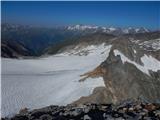
 | Ravenska Kočna - Skuta (past the cableway and over Dolgi hrbet)
Skuta is a 2,532-meter-high mountain located in the heart of the Kamnik-Savinja Alps. From the summit, which has a logbook box and a stamp, a bea...
5 h 45 min |
 | Koča pod slapom Rinka - Skuta (via Turski žleb)
Skuta is a 2,532-meter-high mountain located in the heart of the Kamnik-Savinja Alps. From the summit, which has a logbook box and a stamp, a bea...
5 h 15 min |
| Ravenska Kočna - Skuta (umik Žrela and over Dolgi hrbet)
Skuta is a 2,532-meter-high mountain located in the heart of the Kamnik-Savinja Alps. From the summit, which has a logbook box and a stamp, a bea...
5 h 50 min |
| Ravenska Kočna - Skuta (via Štularjeva planina and Dolgi hrbet)
Skuta is a 2,532-meter-high mountain located in the heart of the Kamnik-Savinja Alps. From the summit, which has a logbook box and a stamp, a bea...
5 h 45 min |
| Ravenska Kočna - Jezerska Kočna (Frischauf way)
Jezerska Kočna is located west of Grintovec. From the summit, there is a very nice view towards Grintovec. The Karawanks and the Gorenjska plain ...
6 h 30 min |
 | Suhadolnik - Jezerska Kočna (via Grdi graben and Dolci)
Jezerska Kočna is located west of Grintovec. From the summit, there is a very nice view towards Grintovec. The Karawanks and the Gorenjska plain ...
5 h 15 min |
| Suhadolnik - Jezerska Kočna (via Kokrsko sedlo and Dolci)
Jezerska Kočna is located west of Grintovec. From the summit, there is a very nice view towards Grintovec. The Karawanks and the Gorenjska plain ...
6 h 15 min |
| V Koncu - Jezerska Kočna (via Dolci)
Jezerska Kočna is located west of Grintovec. From the summit, there is a very nice view towards Grintovec. The Karawanks and the Gorenjska plain ...
6 h |
 | V Koncu - Jezerska Kočna (via Kokrska Kočna)
Jezerska Kočna is located west of Grintovec. From the summit, there is a very nice view towards Grintovec. The Karawanks and the Gorenjska plain ...
6 h |
| Suhadolnik - Jezerska Kočna (via Grdi graben and Kokrska Kočna)
Jezerska Kočna is located west of Grintovec. From the summit, there is a very nice view towards Grintovec. The Karawanks and the Gorenjska plain ...
5 h 15 min |
| Suhadolnik - Jezerska Kočna (via Kokrsko sedlo and Kokrska Kočna)
Jezerska Kočna is located west of Grintovec. From the summit, there is a very nice view towards Grintovec. The Karawanks and the Gorenjska plain ...
6 h 15 min |
| Ravenska Kočna - Jezerska Kočna (umik Žrela and on Frischaufova pot)
Jezerska Kočna is located west of Grintovec. From the summit, there is a very nice view towards Grintovec. The Karawanks and the Gorenjska plain ...
6 h 35 min |
| Ravenska Kočna - Jezerska Kočna (via Štularjeva planina and on path Frischaufova pot)
Jezerska Kočna is located west of Grintovec. From the summit, there is a very nice view towards Grintovec. The Karawanks and the Gorenjska plain ...
6 h 30 min |
 | Erjavčeva koča na Vršiču - Prisank / Prisojnik (Jubilejna pot)
Prisank (also known as Prisojnik) is a 2,547-meter-high mountain situated above the Mlinarica, Krnica, and Suha Pišnica valleys. From the summit,...
6 h 15 min |
 | V Koncu - Grintovec (via Kokrsko and Mlinarsko sedlo)
Grintovec is the highest peak of the Kamnik-Savinja Alps. It is located above the Kamniška Bistrica Valley, Suhi Dol, and the Ravenska Kočna Vall...
5 h 30 min |
| Suhadolnik - Grintovec (via Kokrsko and Mlinarsko sedlo)
Grintovec is the highest peak of the Kamnik-Savinja Alps. It is located above the Kamniška Bistrica Valley, Suhi Dol, and the Ravenska Kočna Vall...
5 h 45 min |
| Ravenska Kočna - Grintovec (past the cableway and on Frischaufova pot)
Grintovec is the highest peak of the Kamnik-Savinja Alps. It is located above the Kamniška Bistrica Valley, Suhi Dol, and the Ravenska Kočna Vall...
5 h 15 min |
 | Ravenska Kočna - Grintovec (past the cableway and on Kremžarjeva pot)
Grintovec is the highest peak of the Kamnik-Savinja Alps. It is located above the Kamniška Bistrica Valley, Suhi Dol, and the Ravenska Kočna Vall...
5 h 15 min |
| Ravenska Kočna - Grintovec (umik Žrela and on Frischaufova pot)
Grintovec is the highest peak of the Kamnik-Savinja Alps. It is located above the Kamniška Bistrica Valley, Suhi Dol, and the Ravenska Kočna Vall...
5 h 20 min |
| Ravenska Kočna - Grintovec (umik Žrela and on Kremžarjeva pot)
Grintovec is the highest peak of the Kamnik-Savinja Alps. It is located above the Kamniška Bistrica Valley, Suhi Dol, and the Ravenska Kočna Vall...
5 h 20 min |
| Ravenska Kočna - Grintovec (via Štularjeva planina and on path Frischaufova pot)
Grintovec is the highest peak of the Kamnik-Savinja Alps. It is located above the Kamniška Bistrica Valley, Suhi Dol, and the Ravenska Kočna Vall...
5 h 30 min |
| Ravenska Kočna - Grintovec (via Štularjeva planina and on path Kremžarjeva pot)
Grintovec is the highest peak of the Kamnik-Savinja Alps. It is located above the Kamniška Bistrica Valley, Suhi Dol, and the Ravenska Kočna Vall...
5 h 30 min |
 | Gozdec - Mali Kanin (Alta Via Resiana)
Mali Kanin is a neighboring mountain to the better-known Visoki Kanin. The peak has a beautiful view of the Kanin mountain chain and, in the back...
6 h 40 min |
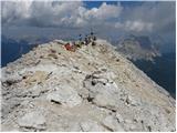
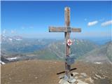
 | Gozdec - Visoki Kanin (via Zadnji dol)
Visoki Kanin is the highest peak of the Kanin mountains. From the summit, which has a cross, there is a nice view of the western Julian Alps, and...
6 h |
 | Sella Nevea - Visoki Kanin (Via ferrata Rosalba Grasselli)
Visoki Kanin is the highest peak of the Kanin mountains. From the summit, which has a cross, there is a nice view of the western Julian Alps, and...
6 h 15 min |
 | Gozdec - Visoki Kanin (via Dom Petra skalarja na Kaninu)
Visoki Kanin is the highest peak of the Kanin mountains. From the summit, which has a cross, there is a nice view of the western Julian Alps, and...
6 h 40 min |
 | Gozdec - Visoki Kanin (Alta Via Resiana)
Visoki Kanin is the highest peak of the Kanin mountains. From the summit, which has a cross, there is a nice view of the western Julian Alps, and...
7 h |
 | Aljažev dom v Vratih - Dolkova špica (eastern way)
Dolkova špica is a 2,591 m high mountain situated between Stenar and Škrlatica. From the summit, which has a registration box, a beautiful panora...
5 h 30 min |
| Ruski križ - Dolkova špica (via Kriška stena)
Dolkova špica is a 2,591 m high mountain situated between Stenar and Škrlatica. From the summit, which has a registration box, a beautiful panora...
5 h 55 min |
 | Aljažev dom v Vratih - Razor (via Sovatna)
The summit of Razor lies above the alpine valley of Mlinarica. Though not spacious, it offers a superb view. All the peaks above the Kriški podi ...
6 h 30 min |
| Ruski križ - Razor (via Kriška stena)
The summit of Razor lies above the alpine valley of Mlinarica. Though not spacious, it offers a superb view. All the peaks above the Kriški podi ...
7 h 30 min |
 | Railway station Hochzirl - Kleiner Solstein (on Höttinger Schützensteig)
Kleiner Solstein is the highest peak of the famous Nordkette ridge, which blocks views from the valley to the central part of the Karwendel range...
6 h |
 | Zadnja Trenta (Flori) - Jalovec (via Jalovška škrbina)
At 2,645 m, Jalovec is the sixth highest mountain in Slovenia. The summit drops steeply towards three alpine valleys (Loška Koritnica, Tamar, and...
5 h 40 min |
| Zadnja Trenta (Flori) - Jalovec (via Zavetišče pod Špičkom)
At 2,645 m, Jalovec is the sixth highest mountain in Slovenia. The summit drops steeply towards three alpine valleys (Loška Koritnica, Tamar, and...
5 h 45 min |
 | NC Planica - Jalovec (past bivouac and Kotovo sedlo)
At 2,645 m, Jalovec is the sixth highest mountain in Slovenia. The summit drops steeply towards three alpine valleys (Loška Koritnica, Tamar, and...
6 h 10 min |
| NC Planica - Jalovec (via Jalovška škrbina)
At 2,645 m, Jalovec is the sixth highest mountain in Slovenia. The summit drops steeply towards three alpine valleys (Loška Koritnica, Tamar, and...
6 h 30 min |
| NC Planica - Jalovec (on scree and over Kotovo sedlo)
At 2,645 m, Jalovec is the sixth highest mountain in Slovenia. The summit drops steeply towards three alpine valleys (Loška Koritnica, Tamar, and...
6 h 10 min |
 | parking lot Stupfer in Gaistal - Hohe Munde - western peak (on climbing path via western ridge)
Hohe Munde is a peak in the Mieming range west of Innsbruck and the local mountain of the town of Telfs, appearing as an imposing rock fortress a...
6 h 15 min |
 | Rio Bianco - Viš/Jof Fuart (Sentiero del Centenario)
Viš is a 2,666 m high peak in the western Julian Alps. From the summit, which features a statue of St. Mary and a cross beside it, there are fine...
6 h |
| Cave del Mole - Viš/Jof Fuart (Anita Goitan)
Viš is a 2,666 m high peak in the western Julian Alps. From the summit, which features a statue of St. Mary and a cross beside it, there are fine...
5 h 30 min |
 | Aljažev dom v Vratih - Mali Triglav (via Prag)
Mali Triglav is an indistinct summit on the main ridge of Triglav. Despite its considerable height, it is rarely chosen as an independent objecti...
5 h 45 min |
| The Kot Valley - Mali Triglav
Mali Triglav is an indistinct summit on the main ridge of Triglav. Despite its considerable height, it is rarely chosen as an independent objecti...
5 h 50 min |
| Aljažev dom v Vratih - Mali Triglav (Tominšek route)
Mali Triglav is an indistinct summit on the main ridge of Triglav. Despite its considerable height, it is rarely chosen as an independent objecti...
5 h 35 min |
| The Krma Valley - Mali Triglav (via Kredarica)
Mali Triglav is an indistinct summit on the main ridge of Triglav. Despite its considerable height, it is rarely chosen as an independent objecti...
5 h 40 min |
| The Krma Valley - Mali Triglav (past Doma Planika pod Triglavom)
Mali Triglav is an indistinct summit on the main ridge of Triglav. Despite its considerable height, it is rarely chosen as an independent objecti...
5 h 25 min |
| Rudno polje - Mali Triglav (via Dom Planika)
Mali Triglav is an indistinct summit on the main ridge of Triglav. Despite its considerable height, it is rarely chosen as an independent objecti...
5 h 50 min |
| Rudno polje - Mali Triglav (via Kredarica)
Mali Triglav is an indistinct summit on the main ridge of Triglav. Despite its considerable height, it is rarely chosen as an independent objecti...
6 h 5 min |
| end of road on Pokljuka - Mali Triglav (via Planika)
Mali Triglav is an indistinct summit on the main ridge of Triglav. Despite its considerable height, it is rarely chosen as an independent objecti...
5 h 25 min |
| end of road on Pokljuka - Mali Triglav (via Kredarica)
Mali Triglav is an indistinct summit on the main ridge of Triglav. Despite its considerable height, it is rarely chosen as an independent objecti...
5 h 40 min |
| Uskovnica (Razpotje) - Mali Triglav (via Planika)
Mali Triglav is an indistinct summit on the main ridge of Triglav. Despite its considerable height, it is rarely chosen as an independent objecti...
5 h 55 min |
 | Aljažev dom v Vratih - Škrlatica
Škrlatica is the second highest mountain in Slovenia. A cross stands on the summit, making it easily recognisable from neighbouring peaks. It als...
6 h |
 | Ruski križ - Škrlatica (via Kriška stena)
Škrlatica is the second highest mountain in Slovenia. A cross stands on the summit, making it easily recognisable from neighbouring peaks. It als...
7 h 45 min |
 | Planina Zajzera - Jôf di Montasio/Montaž (Via Amalia)
Montaž is one of the most imposing and, at 2,753 m, the second-highest mountain in the Julian Alps. Its authentic Slovenian name is Špik nad Poli...
6 h 45 min |
 | Sant'Uberto - Furcia Rossa III
Furcia Rossa III is a 2,791-meter-high peak in a somewhat more remote ridge along which the Walk of Peace (Fridensweg / Via della Pace) runs. At ...
5 h 15 min |
 | Aljažev dom v Vratih - Triglav (Tominšek route)
Triglav is a 2,864 m high mountain located in the heart of the Julian Alps. At this altitude, it is the highest mountain in Slovenia and also the...
6 h 10 min |
| Aljažev dom v Vratih - Triglav (via Prag)
Triglav is a 2,864 m high mountain located in the heart of the Julian Alps. At this altitude, it is the highest mountain in Slovenia and also the...
6 h 20 min |
 | Aljažev dom v Vratih - Triglav (via Plemenice)
Triglav is a 2,864 m high mountain located in the heart of the Julian Alps. At this altitude, it is the highest mountain in Slovenia and also the...
6 h 30 min |
| The Kot Valley - Triglav
Triglav is a 2,864 m high mountain located in the heart of the Julian Alps. At this altitude, it is the highest mountain in Slovenia and also the...
6 h 25 min |
| The Krma Valley - Triglav (via Kredarica)
Triglav is a 2,864 m high mountain located in the heart of the Julian Alps. At this altitude, it is the highest mountain in Slovenia and also the...
6 h 15 min |
| The Krma Valley - Triglav (via Planika and Mali Triglav)
Triglav is a 2,864 m high mountain located in the heart of the Julian Alps. At this altitude, it is the highest mountain in Slovenia and also the...
6 h |
 | The Krma Valley - Triglav (via Planika and Triglavska škrbina)
Triglav is a 2,864 m high mountain located in the heart of the Julian Alps. At this altitude, it is the highest mountain in Slovenia and also the...
5 h 55 min |
| end of road on Pokljuka - Triglav (via Kredarica)
Triglav is a 2,864 m high mountain located in the heart of the Julian Alps. At this altitude, it is the highest mountain in Slovenia and also the...
6 h 15 min |
| end of road on Pokljuka - Triglav (via Planika and Mali Triglav)
Triglav is a 2,864 m high mountain located in the heart of the Julian Alps. At this altitude, it is the highest mountain in Slovenia and also the...
6 h |
| Uskovnica (Razpotje) - Triglav (via Planika and Mali Triglav)
Triglav is a 2,864 m high mountain located in the heart of the Julian Alps. At this altitude, it is the highest mountain in Slovenia and also the...
6 h 30 min |
 | Planina Blato - Triglav (Za Kopico)
Triglav is a 2,864 m high mountain located in the heart of the Julian Alps. At this altitude, it is the highest mountain in Slovenia and also the...
8 h |
| Uskovnica (Razpotje) - Triglav (via Triglavska škrbina)
Triglav is a 2,864 m high mountain located in the heart of the Julian Alps. At this altitude, it is the highest mountain in Slovenia and also the...
6 h 25 min |
| end of road on Pokljuka - Triglav (via Planika and Triglavska škrbina)
Triglav is a 2,864 m high mountain located in the heart of the Julian Alps. At this altitude, it is the highest mountain in Slovenia and also the...
5 h 55 min |
| Rudno polje - Triglav (via Kredarica)
Triglav is a 2,864 m high mountain located in the heart of the Julian Alps. At this altitude, it is the highest mountain in Slovenia and also the...
6 h 40 min |
| Uskovnica (Lom) - Triglav (via Triglavska škrbina)
Triglav is a 2,864 m high mountain located in the heart of the Julian Alps. At this altitude, it is the highest mountain in Slovenia and also the...
6 h 30 min |
| Rudno polje - Triglav (via Dom Planika and Mali Triglav)
Triglav is a 2,864 m high mountain located in the heart of the Julian Alps. At this altitude, it is the highest mountain in Slovenia and also the...
6 h 25 min |
| Rudno polje - Triglav (past Dom Planika and Triglavska škrbina)
Triglav is a 2,864 m high mountain located in the heart of the Julian Alps. At this altitude, it is the highest mountain in Slovenia and also the...
6 h 20 min |
 | Parkplatz Erichhütte - Hochkönig (path 432)
Hochkönig is, at 2941 meters, the highest peak of the Berchtesgaden Alps. The peak, on which the Matrashaus mountain hut stands, is very well vis...
5 h 20 min |
 | Alba di Canazei - Cima Ombretta (Via Ferrata Ombretta)
Cima Ombretta is a 3,011-meter-high peak in the Marmolada mountain group. From the summit, where a cross stands, there is the finest view of the ...
5 h 15 min |
 | Rifugio Pederü - Sasso delle Dieci / Zehnerspitze (path 12)
Sasso delle Dieci / Zehnerspitze is a 3,028-meter-high mountain rising steeply above Val Badia valley. Sasso delle Dieci is the highest peak in t...
5 h 30 min |
| Rifugio Pederü - Sasso delle Dieci / Zehnerspitze (path 7)
Sasso delle Dieci / Zehnerspitze is a 3,028-meter-high mountain rising steeply above Val Badia valley. Sasso delle Dieci is the highest peak in t...
5 h 35 min |
 | Lenzanger - Goldzechkopf (via Hoher Sonnblick)
Goldzechkopf is a 3042-meter-high peak in the Goldberg mountain group. The summit is located on the ridge between the better-known Hoher Sonnblic...
6 h 10 min |
 | Rifugio Pederü - Piz dles Conturines
Piz dles Conturines, at 3064 m, is the highest peak in the Lavarella group. From the cross-topped summit, there are fine views of the entire grou...
6 h 30 min |
 | Lenzanger - Hoher Sonnblick (via Goldzechkopf)
Hoher Sonnblick, also known as Rauriser Sonnblick, is a 3106-meter-high mountain in the Goldberg group. The Zittelhaus hut and Austria's highest ...
6 h 30 min |
 | Palafavera - Monte Civetta (Via Normale)
Monte Civetta is one of the main mountains in the Dolomites. It is recognizable primarily by its more than 1000-meter-high northwestern wall. Thi...
6 h 20 min |
 | Lenzanger - Hocharn (via Hoher Sonnblick)
Hocharn (also Hoher Aar, Hochnarr) is the highest peak in the Goldberg mountain group at 3254 meters. The summit is located on the border between...
7 h 45 min |
 | Gschnitz - Habicht (normal path past Innsbrucker Hütte (Gschnitz))
Habicht (Slovenian "kragulj" or goshawk) is a broad and imposing mountain rising high above the Stubai and Obertal valleys. Due to its somewhat i...
5 h 30 min |
| parking lot at guesthouse Feuerstein - Habicht (normal path past Innsbrucker Hütte (Feuerstein))
Habicht (Slovenian "kragulj" or goshawk) is a broad and imposing mountain rising high above the Stubai and Obertal valleys. Due to its somewhat i...
5 h 15 min |
 | Alba di Canazei - Punta Penia (Marmolada)
Punta Penia, at 3,343 meters, is the highest peak of Marmolada and the Italian Dolomites. From the summit, where there is a small mountain hut (s...
6 h 15 min |