 | Bukovnik - Velika Raduha (via Durce)
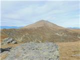
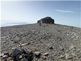
Velika Raduha, at 2062 m, is the highest peak of the Raduha range, which rises steeply east of Robanov Kot. From the summit, with its registratio...
2 h 50 min |
 | Planina Vodol - Velika Raduha
Velika Raduha, at 2062 m, is the highest peak of the Raduha range, which rises steeply east of Robanov Kot. From the summit, with its registratio...
2 h 40 min |
 | End of road on Vogar - Mala Tičarica (via Štapce)
Mala Tičarica is a highly panoramic mountain above the Twin Triglav Lakes. From the summit there is a beautiful view toward the Koča pri Triglavs...
3 h 30 min |
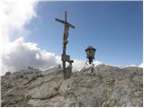
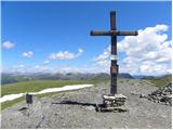
 | Dom na Gospincu - Kalški greben (via Dolga Njiva)
Kalški greben is a 2224 m high peak and the highest point of the ridge bearing the same name. From the summit, where there is a summit register a...
3 h 20 min |
 | Planina Podvežak - Veliki vrh (Veža) (via Prag)
Veliki Vrh is a 2,110-metre-high mountain located in the central part of the Dleskovec Plateau. From the summit, where there are two registration...
2 h 20 min |
 | Planina Ravne - Veliki vrh (Veža) (via Zelene trate)
Veliki Vrh is a 2,110-metre-high mountain located in the central part of the Dleskovec Plateau. From the summit, where there are two registration...
2 h 15 min |
| Planina Ravne - Veliki vrh (Veža) (via Dolga trata)
Veliki Vrh is a 2,110-metre-high mountain located in the central part of the Dleskovec Plateau. From the summit, where there are two registration...
2 h 30 min |
| Kraljev dol - Veliki vrh (Veža) (via Planina Vodole)
Veliki Vrh is a 2,110-metre-high mountain located in the central part of the Dleskovec Plateau. From the summit, where there are two registration...
2 h 35 min |
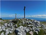
 | Waldheimhütte - Zirbitzkogel (Direct way)
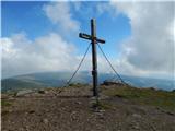
Zirbitzkogel, at 2,396 m, is the highest peak of the Labotniške Alpe / Seetaler Alpen. From the summit, where a cross and a panorama board stand,...
2 h 17 min |
| Waldheimhütte - Zirbitzkogel (via Wildsee)
Zirbitzkogel, at 2,396 m, is the highest peak of the Labotniške Alpe / Seetaler Alpen. From the summit, where a cross and a panorama board stand,...
3 h 32 min |
 | Winterleiten parking - Zirbitzkogel
Zirbitzkogel, at 2,396 m, is the highest peak of the Labotniške Alpe / Seetaler Alpen. From the summit, where a cross and a panorama board stand,...
2 h 17 min |
 | Tonnerhütte - Zirbitzkogel
Zirbitzkogel, at 2,396 m, is the highest peak of the Labotniške Alpe / Seetaler Alpen. From the summit, where a cross and a panorama board stand,...
2 h 32 min |
| Waldheimhütte - Zirbitzkogel (via Rothaidenhütte)
Zirbitzkogel, at 2,396 m, is the highest peak of the Labotniške Alpe / Seetaler Alpen. From the summit, where a cross and a panorama board stand,...
3 h 7 min |
| Waldheimhütte - Zirbitzkogel (via Lavantsee)
Zirbitzkogel, at 2,396 m, is the highest peak of the Labotniške Alpe / Seetaler Alpen. From the summit, where a cross and a panorama board stand,...
2 h 47 min |
 | Waldheimhütte - Fuchskogel (via Wildsee)
Fuchskogel is a peak south of Zirbitzkogel in the Seetaler Alpen mountain group. The summit is broad and mostly covered in grass. More precisely,...
2 h 45 min |
 | Tonnerhütte - Fuchskogel
Fuchskogel is a peak south of Zirbitzkogel in the Seetaler Alpen mountain group. The summit is broad and mostly covered in grass. More precisely,...
2 h 20 min |
 | Waldheimhütte - Scharfes Eck (Direct way)
Scharfes Eck is a peak on which stands an Austrian meteorological radar station. From the summit, there is a beautiful view of the neighbouring p...
2 h 45 min |
 | Winterleiten parking - Scharfes Eck
Scharfes Eck is a peak on which stands an Austrian meteorological radar station. From the summit, there is a beautiful view of the neighbouring p...
2 h |
| Tonnerhütte - Scharfes Eck
Scharfes Eck is a peak on which stands an Austrian meteorological radar station. From the summit, there is a beautiful view of the neighbouring p...
3 h |
 | Salzstiegelhaus - Weißenstein (Packalpe)
Weißenstein is a grassy mountain crisscrossed with wire fences. From its indistinct summit, there is a nice view of the neighboring Ameringkogel ...
2 h 20 min |
 | Salzstiegelhaus - Ameringkogel (Packalpe)
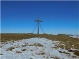
Ameringkogel is a grassy summit with a cross and summit register. At 2,187 meters, it is the highest peak of the Packalpe. In good visibility, th...
2 h 30 min |
 | Walischeben - Großenberg (Packalpe) (via Ameringkogel)
Großenberg, also known as Größing, is the northernmost two-thousander in the Packalpe mountain group. From its expansive grassy summit, where a t...
2 h 25 min |
| Walischeben - Großenberg (Packalpe) (below the Ameringkogel summit)
Großenberg, also known as Größing, is the northernmost two-thousander in the Packalpe mountain group. From its expansive grassy summit, where a t...
2 h 20 min |
| Salzstiegelhaus - Großenberg (Packalpe) (via Ameringkogel)
Großenberg, also known as Größing, is the northernmost two-thousander in the Packalpe mountain group. From its expansive grassy summit, where a t...
3 h |
| Salzstiegelhaus - Großenberg (Packalpe)
Großenberg, also known as Größing, is the northernmost two-thousander in the Packalpe mountain group. From its expansive grassy summit, where a t...
2 h 55 min |
 | Jakobe - Petzen (Kordeschkopf) (Peca (Kordeževa glava)) (easy path)
Kordeževa glava, better known as Peca, is the highest peak of the Peca range. It is located on the border with Austria above the Mežiška dolina v...
2 h 15 min |
 | Plattner - Gartnerkofel (via Watschiger Alm)
Gartnerkofel is a 2,195-meter-high mountain in the Nassfeld ski area. Its Slovenian name is Krniške skale. From the summit, where a cross stands,...
2 h |
 | Planina Ravne - Velika Zelenica (via Zelene trate)
Velika Zelenica is the highest peak of the Dleskovška plateau, offering panoramic views accordingly. The nearby Ojstrica stands out most prominen...
2 h 15 min |
 | Planina Podvežak - Velika Zelenica (via Prag)
Velika Zelenica is the highest peak of the Dleskovška plateau, offering panoramic views accordingly. The nearby Ojstrica stands out most prominen...
2 h 30 min |
| Planina Ravne - Velika Zelenica (via Dolga trata)
Velika Zelenica is the highest peak of the Dleskovška plateau, offering panoramic views accordingly. The nearby Ojstrica stands out most prominen...
2 h 30 min |
 | Rosstratte - Dobratsch / Dobrač (by road)
Dobrač, or in German Dobratsch and also known as Villacher Alpen, is a 2166-meter-high mountain situated on the far eastern edge of the Gailtal A...
2 h |
 | Weinebene - Großer Speikkogel (Koralpe) (panoramic path)
Großer Speikkogel is, at 2,140 meters, the highest peak of Golica/Koralpe, a range east of Volšperk/Wolfsberg. From the summit, where a cross and...
3 h |
| Weinebene - Großer Speikkogel (Koralpe) (via Schäferkreuz)
Großer Speikkogel is, at 2,140 meters, the highest peak of Golica/Koralpe, a range east of Volšperk/Wolfsberg. From the summit, where a cross and...
3 h 15 min |
| Smučišče Koralpe (Koralpenparkplatz) - Großer Speikkogel (Koralpe) (via Großhöllerhütte)
Großer Speikkogel is, at 2,140 meters, the highest peak of Golica/Koralpe, a range east of Volšperk/Wolfsberg. From the summit, where a cross and...
3 h |
 | parking below Weinebene - Großer Speikkogel (Koralpe) (panoramic path)
Großer Speikkogel is, at 2,140 meters, the highest peak of Golica/Koralpe, a range east of Volšperk/Wolfsberg. From the summit, where a cross and...
3 h |
| parking below Weinebene - Großer Speikkogel (Koralpe) (via cross Schäferkreuz)
Großer Speikkogel is, at 2,140 meters, the highest peak of Golica/Koralpe, a range east of Volšperk/Wolfsberg. From the summit, where a cross and...
3 h 15 min |
| parking below Weinebene - Großer Speikkogel (Koralpe) (via Grünangerhütte)
Großer Speikkogel is, at 2,140 meters, the highest peak of Golica/Koralpe, a range east of Volšperk/Wolfsberg. From the summit, where a cross and...
3 h 10 min |
 | Smučišče Koralpe (Koralpenparkplatz) - Großer Speikkogel (Koralpe) (by the edge of the Großes Kar plateau)
Großer Speikkogel is, at 2,140 meters, the highest peak of Golica/Koralpe, a range east of Volšperk/Wolfsberg. From the summit, where a cross and...
2 h 15 min |
 | Ladinger Straße - Ladinger Spitz (Saualpe) (via Ladinger Hütte)
Velika Svinja, known in German as Ladinger Spitz, is at 2079 m the highest peak of the Svinja / Saualpe mountain range. From the summit, which ha...
3 h |
 | Ladinger Straße - Ladinger Spitz (Saualpe) (via Wolfsberger Hütte)
Velika Svinja, known in German as Ladinger Spitz, is at 2079 m the highest peak of the Svinja / Saualpe mountain range. From the summit, which ha...
2 h 50 min |
 | Klippitztörl - Ladinger Spitz (Saualpe)
Velika Svinja, known in German as Ladinger Spitz, is at 2079 m the highest peak of the Svinja / Saualpe mountain range. From the summit, which ha...
3 h 35 min |
 | Ladinger Straße - Ladinger Spitz (Saualpe) (via Offnerhütte)
Velika Svinja, known in German as Ladinger Spitz, is at 2079 m the highest peak of the Svinja / Saualpe mountain range. From the summit, which ha...
2 h 25 min |
| Ladinger Straße - Ladinger Spitz (Saualpe) (via Zechhütte)
Velika Svinja, known in German as Ladinger Spitz, is at 2079 m the highest peak of the Svinja / Saualpe mountain range. From the summit, which ha...
2 h 20 min |
 | Heidi Alm - Klomnock
Klomnock is the house mountain of the Nockalmstraße alpine road, leading to the Schiestelscharte pass (2,024 m). From the summit, where a cross s...
2 h 15 min |
 | Turracher Höhe - Kaserhöhe
Kaserhöhe is a panoramic peak located in Austrian Carinthia in the heart of the Gurktal Alps. On the spacious summit, which is partly covered in ...
2 h 20 min |
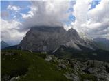
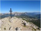
 | Passo Falzarego - Lagazuoi Piccolo (normal way)
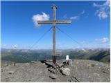
Lagazuoi Piccolo is a 2,778 m high mountain located north of the Passo Falzarego pass (2,105 m). From the summit, where a cross stands, there is ...
2 h 15 min |
| Passo Valparola - Lagazuoi Piccolo
Lagazuoi Piccolo is a 2,778 m high mountain located north of the Passo Falzarego pass (2,105 m). From the summit, where a cross stands, there is ...
2 h 45 min |
 | Rifugio Tolazzi - Monte Floriz
Monte Floriz is a 2,184 m high grassy peak located south of the Marinelli hut. From the summit there is a very nice view of the Coglians group; i...
2 h 25 min |
 | Panoramarestaurant Oben - Feistritzer Spitze
Bistriška špica is a 2113 m high peak located on the Austrian side of Peca. From the summit, which features a cross, there is a fine view of the ...
2 h 5 min |
 | Panoramarestaurant Oben - Feistritzer Spitze (past old cotage)
Bistriška špica is a 2113 m high peak located on the Austrian side of Peca. From the summit, which features a cross, there is a fine view of the ...
2 h |
 | Jakobe - Končnikov vrh (Peca) (easy path)
Končnikov vrh (German: Knieps) is a 2109 m high peak situated in the central part of Peca. From the grassy summit, there is a beautiful view of t...
2 h 45 min |
 | Volkzeinalm - Hochalmspitze (Villgraten)
Hochalmspitze is a 2797-meter-high peak located in the southwestern part of the High Tauern in the Villgraten mountain group. This peak is much l...
2 h 45 min |
 | Plockenpass - Creta di Collinetta / Cellon
Creta di Collinetta / Cellon is a 2,238-meter-high mountain located west of the Plöcken Pass. From the summit, which features a cross, there is a...
3 h |
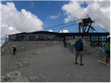 | Passo Pordoi - Sass de Pordoi
Sass de Pordoi is a 2,950-meter-high peak located north of the Passo Pordoi alpine pass. The Rifugio Maria mountain hut stands on the summit, rea...
2 h |
 | Rifugio Selvapiana I.Lunelli - Croda Sora I Colesei / Arzalpenkopf (via Forcella Popera)
Croda Sora I Colesei (German: Arzalpenkopf) is a 2,321-meter-high mountain on the eastern edge of the Sexten Dolomites (Dolomiti di Sesto). The s...
2 h 30 min |
| Rifugio Selvapiana I.Lunelli - Croda Sora I Colesei / Arzalpenkopf (via Belvedere)
Croda Sora I Colesei (German: Arzalpenkopf) is a 2,321-meter-high mountain on the eastern edge of the Sexten Dolomites (Dolomiti di Sesto). The s...
2 h 30 min |
 | Heidi Alm - Mallnock
Mallnock is a 2226 m high peak located north of the settlement St. Oswald in the Krške Alpe. From the summit, where a cross stands, a beautiful v...
2 h 30 min |
 | Heidi Alm - Mallnock (via Klomnock)
Mallnock is a 2226 m high peak located north of the settlement St. Oswald in the Krške Alpe. From the summit, where a cross stands, a beautiful v...
2 h 45 min |
 | Malga Crocifisso - Sas de Adam
Sas de Adam (also Sass de Dama) is a 2,430-meter-high peak situated north of the alpine valley Val Sen Nicolo. From the top, a nice view opens up...
2 h 35 min |
 | Passo Gardena - Sas Ciampac
Sas Ciampac is a 2672-meter-high peak in the Puez group. From the summit, which features a small wooden cross, there is a nice view of the Puez g...
2 h |
 | Rifugio Rio Gere - Rifugio Tondi
Rifugio Tondi is situated a few meters below the summit of Monte Ciasadio, the highest point of the Faloria ski slope. From the hut, there is a v...
2 h 15 min |
 | Passo Staulanza - Monte Pena
Monte Pena is a 2,196-meter-high mountain in the Pelmo group. From its summit, topped by a cross, there are superb views of nearby Monte Pelmo an...
3 h 30 min |
 | Rifugio Valparola - Setsas
The Setsas peak is located west of the Passo Valparola pass and is somewhat distant from the highest summits. Precisely because of this remotenes...
2 h 30 min |
| Passo Campolongo - Setsas
The Setsas peak is located west of the Passo Valparola pass and is somewhat distant from the highest summits. Precisely because of this remotenes...
3 h 40 min |
 | Obertauern - Gamsleitenspitze
Gamsleitenspitze is a 2359-meter-high mountain in the Radstädter Tauern mountain group. From the summit, located above the Obertauern ski center,...
2 h |
 | Sadnighaus - Sadnig (direct way (path 150))
Sadnig or Hoher Sadnig is a relatively easily accessible and panoramic mountain in the eponymous Sadnig group (German: Sadniggruppe), the souther...
2 h 45 min |
 | Sadnighaus - Sadnig (via mountain pasture Lindler (pot 149))
Sadnig or Hoher Sadnig is a relatively easily accessible and panoramic mountain in the eponymous Sadnig group (German: Sadniggruppe), the souther...
3 h 15 min |
 | Malga Crocifisso - Col de Valvacin
Col de Valvacin is a 2,372-meter-high peak on the west side of the Marmolada group near the Buffaure ski slopes. Rifugio el Zedron mountain hut i...
2 h 15 min |
 | Passo San Pellegrino - Col Margherita
Col Margherita is a 2,514-meter-high mountain rising above the San Pellegrino Pass in the Dolomites. Several cableways lead to it, and in the sum...
3 h |
| Vitlenica - Veliki Vilinac (Vitlenica - Vilinac)
Veliki Vilinac is one of the peaks of the Čvrsnica mountain range, located west of Jablanica in Blidinje Nature Park. Čvrsnica is bounded by the ...
3 h |
 | Sella di Razzo - Clapsavon (via 210)
Clapsavon is a 2,462-meter-high mountain in the Carnic Alps in Italy. It lies about an hour's walk west of the 2,474-meter-high Bivera. Both peak...
3 h |
 | Lakkos tou Mygerou - Agathias (Kreta)
Agathias is the fourth-highest mountain on the island of Crete in Greece, at 2,424 meters. Agathias (Gr. Αγκαθιάς) is located southeast of Timios...
3 h |
 | Lakkos tou Mygerou - Timios Stavros / Psiloritis (Kreta)
Timios Stavros is Crete's highest mountain at 2,456 meters and also the highest among the Greek islands. Due to its topographic prominence, it is...
3 h |
 | parking below Weinebene - Krakaberg (Golica / Koralpe) (panoramic path)
Krakaberg is a 2,070-meter-high peak located south of Großer Speikkogel, the highest peak of Golica / Koralpe. From the summit, a nice view opens...
3 h 10 min |
 | parking below Weinebene - Steinschneider (via Großes Kar)
Steinschneider is a 2070-meter-high peak in the Golica / Koralpe mountain range, situated northwest of Großer Speikkogel, the highest peak of the...
3 h 15 min |
| Weinebene - Steinschneider (above Pomswasserfall)
Steinschneider is a 2070-meter-high peak in the Golica / Koralpe mountain range, situated northwest of Großer Speikkogel, the highest peak of the...
3 h 20 min |
| parking below Weinebene - Steinschneider (above Pomswasserfall)
Steinschneider is a 2070-meter-high peak in the Golica / Koralpe mountain range, situated northwest of Großer Speikkogel, the highest peak of the...
3 h 20 min |