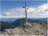
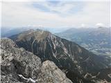
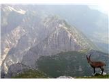
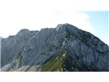
 | Vršič - Prisank / Prisojnik (Slovenian way)
Prisank (also known as Prisojnik) is a 2,547-meter-high mountain situated above the Mlinarica, Krnica, and Suha Pišnica valleys. From the summit,...
3 h 30 min |
| Erjavčeva koča na Vršiču - Prisank / Prisojnik (Slovenska pot)
Prisank (also known as Prisojnik) is a 2,547-meter-high mountain situated above the Mlinarica, Krnica, and Suha Pišnica valleys. From the summit,...
3 h 45 min |
 | Ogris - Hochstuhl/Stol
Stol is, at 2,236 m, the highest peak in the Karawanks. From the summit, which has a registration box and stamp, a beautiful view opens onto the ...
4 h 30 min |
 | Ljubelj - Loibler Baba/Košutica (via koča na Ljubelju)
Košutica (also known as Ljubeljska Baba) is a panoramic mountain north of the western ridge of Košuta. From the summit, marked by a small cross a...
2 h 45 min |
 | Bučan - Loibler Baba/Košutica
Košutica (also known as Ljubeljska Baba) is a panoramic mountain north of the western ridge of Košuta. From the summit, marked by a small cross a...
2 h 45 min |
 | Planina Podvežak - Planjava (via Srebrno sedlo)
Planjava is a smaller mountain group east of Kamniško sedlo. It has two peaks eastern and western. The marked path leads to the eastern peak, wh...
4 h 15 min |
 | Kraljev dol - Planjava (via Srebrno sedlo)
Planjava is a smaller mountain group east of Kamniško sedlo. It has two peaks eastern and western. The marked path leads to the eastern peak, wh...
4 h 30 min |
 | The Krma Valley - Mrežce
Mrežce is a panoramic peak near Lipanski vrh, which is visible on the other side of the gully between the two peaks. Since the slopes towards Pok...
2 h 55 min |
 | The Krma Valley - Lipanski vrh
The panoramic Lipanski vrh is located above the Blejska koča on the Lipanca mountain pasture. From the summit, which drops steeply towards the Kr...
2 h 45 min |
 | The Krma Valley - Debela peč
Debela peč is a 2014 m high mountain that rises steeply above the Krma valley on one side and gently descends towards the expansive Pokljuka fore...
3 h 30 min |
 | Dom pod Storžičem - Storžič (via Škarjev rob)
Storžič is a 2132 m high mountain located in the western part of the Kamnik-Savinja Alps. From the summit, where there is a cross, a beautiful vi...
3 h 5 min |
 | Jekarica - Storžič
Storžič is a 2132 m high mountain located in the western part of the Kamnik-Savinja Alps. From the summit, where there is a cross, a beautiful vi...
3 h |
| Tržiški graben - Storžič (via Javorniški preval)
Storžič is a 2132 m high mountain located in the western part of the Kamnik-Savinja Alps. From the summit, where there is a cross, a beautiful vi...
3 h 45 min |
 | Koča pod slapom Rinka - Brana
Brana is a mountain above Kamniško sedlo. From the spacious summit, which has a registration box and a small cross, there is a very beautiful vie...
3 h 45 min |
 | Erjavčev rovt - Mittagskogel/Kepa
Kepa (also Jepa, German: Mittagskogel) is a panoramic mountain in the western Karavanke, located on the border ridge between Slovenia and Austria...
3 h 50 min |
| Ravne - Mittagskogel/Kepa
Kepa (also Jepa, German: Mittagskogel) is a panoramic mountain in the western Karavanke, located on the border ridge between Slovenia and Austria...
4 h 15 min |
 | Iličev rovt / Illitsch Rauth - Mittagskogel/Kepa (path 680)
Kepa (also Jepa, German: Mittagskogel) is a panoramic mountain in the western Karavanke, located on the border ridge between Slovenia and Austria...
3 h |
 | Planina Podvežak - Ojstrica (via Kocbekov dom)
Ojstrica, named for its sharp shape, rises steeply above Korošica, the Logarska Dolina valley, and Robanov Kot. From the summit, which has a regi...
4 h |
 | Planina Podvežak - Ojstrica (via Mala Ojstrica)
Ojstrica, named for its sharp shape, rises steeply above Korošica, the Logarska Dolina valley, and Robanov Kot. From the summit, which has a regi...
3 h 30 min |
| Planina Ravne - Ojstrica (via Mala Ojstrica)
Ojstrica, named for its sharp shape, rises steeply above Korošica, the Logarska Dolina valley, and Robanov Kot. From the summit, which has a regi...
4 h 15 min |
| Kraljev dol - Ojstrica (via Mala Ojstrica)
Ojstrica, named for its sharp shape, rises steeply above Korošica, the Logarska Dolina valley, and Robanov Kot. From the summit, which has a regi...
3 h 45 min |
| Kraljev dol - Ojstrica (via Kocbekov dom)
Ojstrica, named for its sharp shape, rises steeply above Korošica, the Logarska Dolina valley, and Robanov Kot. From the summit, which has a regi...
4 h 15 min |
 | Planina Zapleč - Krn
Krn, at 2244 m, is the highest peak of the Krn mountain group, which rises steeply above the central part of the Soča River. From the summit, fea...
4 h 30 min |
 | The Krma Valley - Brda
Brda is a panoramic peak situated between Pokljuka and Krma. The summit has a stamp attached to a metal pole and offers a beautiful view towards ...
2 h 55 min |
 | Makekova Kočna - Vratca
The peak of Vratca stands west of Češka koča and is recognisable by its tower-like shape. There is little space on the very summit, but it offers...
2 h 45 min |
 | Podnar / Bodenbauer - Prešernova koča na Stolu
The Prešernova koča na Stolu mountain hut is located just a few metres below the summit of the 2198 m high Mali Stol. From the hut or the nearby ...
4 h 25 min |
| Vgriz / Ogris - Prešernova koča na Stolu
The Prešernova koča na Stolu mountain hut is located just a few metres below the summit of the 2198 m high Mali Stol. From the hut or the nearby ...
4 h 25 min |
 | Planina Jezerca - Vrh Korena (via Dom na Krvavcu)
Vrh Korena is located between Zvoh and Kalški greben near the Krvavec ski resort. The summit offers a beautiful view of the highest peaks in the ...
2 h 55 min |
 | Kriška planina - Kalški greben (via Zvoh)
Kalški greben is a 2224 m high peak and the highest point of the ridge bearing the same name. From the summit, where there is a summit register a...
4 h 10 min |
| Dom na Gospincu - Kalški greben (via Zvoh)
Kalški greben is a 2224 m high peak and the highest point of the ridge bearing the same name. From the summit, where there is a summit register a...
4 h 10 min |
| Planina Jezerca - Kalški greben (via Dom na Krvavcu and Zvoh)
Kalški greben is a 2224 m high peak and the highest point of the ridge bearing the same name. From the summit, where there is a summit register a...
4 h 25 min |
 | Pod Krnico - Koschutnikturm (Košutnikov turn) (eastern way)
Košutnikov Turn is the highest peak in Košuta, the longest Slovenian ridge. The summit offers a beautiful view of the entire ridge. Austria and t...
2 h 30 min |
 | Bodenbauer - Ovčji vrh (Kozjak) / Geissberg (Kosiak) (direct way)
Ovčji Vrh or Kozjak, known in German as Geissberg or Kosiak, is a 2024 m high peak located north of the main Karawanks ridge. Rising above Celovš...
3 h |
| Ogris - Ovčji vrh (Kozjak) / Geissberg (Kosiak) (direct way)
Ovčji Vrh or Kozjak, known in German as Geissberg or Kosiak, is a 2024 m high peak located north of the main Karawanks ridge. Rising above Celovš...
3 h |
| Bodenbauer - Ovčji vrh (Kozjak) / Geissberg (Kosiak) (via Klagenfurter Hütte)
Ovčji Vrh or Kozjak, known in German as Geissberg or Kosiak, is a 2024 m high peak located north of the main Karawanks ridge. Rising above Celovš...
3 h 15 min |
| Ogris - Ovčji vrh (Kozjak) / Geissberg (Kosiak) (via Klagenfurter Hütte)
Ovčji Vrh or Kozjak, known in German as Geissberg or Kosiak, is a 2024 m high peak located north of the main Karawanks ridge. Rising above Celovš...
3 h 15 min |
 | Bodenbauer - Bielschitza/Svačica
Svačica is a less prominent peak in the main ridge of the Karawanks. It lies between Vrtača and Stol, slightly offset to the north. The summit, m...
3 h 15 min |
| Ogris - Bielschitza/Svačica
Svačica is a less prominent peak in the main ridge of the Karawanks. It lies between Vrtača and Stol, slightly offset to the north. The summit, m...
3 h 15 min |
 | Tolminske Ravne - Vogel (steep path)
Many associate the name Vogel first with the Vogel ski resort near the eponymous peak. From the north, it is recognizable by its pyramidal shape,...
3 h |
| Tolminske Ravne - Vogel (steep path and over Globoko)
Many associate the name Vogel first with the Vogel ski resort near the eponymous peak. From the north, it is recognizable by its pyramidal shape,...
3 h 45 min |
 | Ravenska Kočna - Velika (Koroška) Baba (via Jenkova planina)
Velika (Koroška) Baba is a 2127 m high mountain on the border ridge above the Ravenska Kočna valley on the Slovenian side and above the Bela (Bel...
3 h 30 min |
 | Podolševa (Sveti Duh, Strevc) - Govca (Olševa) (via Obel kamen)
Govca is the highest peak of the Olševa range, rising above Koprivna, Solčava, and Remšenik (Remšenik/Remschenig is a valley on the Austrian side...
2 h 30 min |
 | Tolminske Ravne - Vrh nad Škrbino (on steep and direct path)
Vrh nad Škrbino is the easternmost two-thousander in the ridge of the Lower Bohinj Mountains. From the summit, there are excellent views of the n...
3 h 30 min |
 | Goldberg - Torkofel
Torkofel is the highest peak of the panoramic Jauken ridge, which extends north of the Gailtal valley. From the summit cross, there is a nice vie...
3 h 45 min |
 | Jochalm - Reißkofel (235-1)
Reißkofel is a 2371 m high mountain in the Gailtal Alps. The summit, marked by a cross, also features a summit register. The view is particularly...
3 h |
 | Jochalm - Reißkofel (path 235)
Reißkofel is a 2371 m high mountain in the Gailtal Alps. The summit, marked by a cross, also features a summit register. The view is particularly...
3 h 25 min |
 | Reißkofelbad - Kleiner Reißkofel
Kleiner Reißkofel is a 2,161-meter-high mountain east of Reißkofel. From the summit, where a cross stands, there are fine views of the nearby Rei...
3 h 30 min |
 | Göriach - Scharnock
Scharnock is a panoramic peak located in the Schladminger Tauern group. From the summit, where a cross stands, there is a nice view of the surrou...
3 h 30 min |
 | Belopeška jezera - Mala Ponca / Ponza Piccola
Mala Ponca is a 1,925 m high peak between Planica and the Belopeška lakes. Though lower than neighboring Visoka Ponca, it offers fine viewsespeci...
2 h 45 min |
 | Spodnje Belopeško jezero - Mala Ponca / Ponza Piccola (on ridge)
Mala Ponca is a 1,925 m high peak between Planica and the Belopeška lakes. Though lower than neighboring Visoka Ponca, it offers fine viewsespeci...
3 h |
 | Plockenpass - Monte Floriz
Monte Floriz is a 2,184 m high grassy peak located south of the Marinelli hut. From the summit there is a very nice view of the Coglians group; i...
3 h |
 | The Krma Valley - Okroglež
Okroglež is a peak covered with dwarf pines, located between Debela peč and Brda. From the summit, which has a stamp (no logbook), a nice view op...
3 h 10 min |
 | Sella Nevea - Monte Bila pec
Bela peč (Italian: Monte Bila pec) is a 2,146-meter-high mountain located north of the main Kanin ridge. From the summit, which has a logbook box...
2 h 45 min |
 | Planina Pecol - Strma peč / Monte Cimone (path 640 via notch Vandul)
Strma Peč is located west of Montaž, more precisely between the Reklanica and Dunja valleys. From the summit, where a bivouac once stood, there i...
4 h |
 | Ljubelj - Lokovnikov Grintovec / Grintoutz (via Koča na Ljubelju)
Lokovnikov Grintovec is a dwarf pine-covered peak north of Košutica, separated from it by Dovjakovo sedlo saddle (1,728 m). Its southwestern and ...
2 h 45 min |
 | Bučan - Lokovnikov Grintovec / Grintoutz
Lokovnikov Grintovec is a dwarf pine-covered peak north of Košutica, separated from it by Dovjakovo sedlo saddle (1,728 m). Its southwestern and ...
2 h 45 min |
 | Planina Zapleč - Krnčica
Krnčica is a peak in the undulating ridge stretching from Bovec to Krn. It is actually Krn's northwestern ridge. It is comfortably accessible alo...
2 h 40 min |
 | Tolminske Ravne - Zeleni vrh (via planina Razor)
Zeleni vrh is a 2052-meter-high mountain located east of the highest peak of the Spodnje Bohinjske gore. From the grassy summit, which drops prec...
4 h 20 min |
 | Coot Parking Lot - Velika Baba (Kanin) (over Zg. Brda and saddle Med Baban)
Velika Baba is the southernmost two-thousander of the Kanin mountains. It is separated from the main ridge to the north by the saddle Med Baban, ...
3 h 15 min |
 | Coot Parking Lot - Velika Baba (Kanin) (via Skutnik)
Velika Baba is the southernmost two-thousander of the Kanin mountains. It is separated from the main ridge to the north by the saddle Med Baban, ...
4 h 20 min |
 | Bergheimat - Dachskofel (via Scharnik)
Dachskofel is a 2,373 m high mountain in Austria's Hohe Tauern above the town of Irschen and near Lamnitzsee. A wooden cross stands on the summit...
3 h 50 min |
 | Spodnje Sleme - Obel kamen (Olševa)
Obel kamen is a 1,911-meter-high peak located in the ridge of Olševa. On the summit is a border stone marked RS XXII 1; a cross and summit logboo...
3 h 30 min |
 | Weißenbach - Spitzegel / Negal (via Bodenalm)
Spitzegel / Negal is a 2,119 m high mountain in the Gailtal Alps in Austria. The ridge with its highest peak Spitzegel / Nagal logically connects...
4 h 30 min |
 | Passo di Sant'Antonio - Monte Aiarnola (via normale)
Monte Aiarnola is a mountain at the far eastern end of the Sexten Dolomites group. From it there is a nice view towards the western Carnic Alps, ...
3 h 30 min |
 | Cima Sappada - Creton di Tul
Creton di Tul is a 2,288-metre mountain in the Pesarina Dolomites group of the Carnic Alps in Italy, south of Sappada and west of the neighbourin...
3 h 30 min |
 | Cima Sappada - Creta Forata
Creta Forata is a 2,462-meter-high mountain in the Pesarina Dolomites group of the Carnic Alps in Italy, south of Sappada. A small cross and a st...
4 h |
 | Planina Zapleč - Srednji vrh (at Krn)
Srednji vrh is a 2134-meter-high peak located in the ridge between Krn and Krnčica. A marked path leads to the summit, which offers very nice vie...
3 h 10 min |