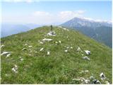
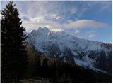
 | Planina Vetrh - Veliki Javornik (Ženiklovec)
Veliki Javornik (also known as Ženiklovec) is a 1716 m high peak located between Storžič and Stegovnik. From the grassy summit with its registrat...
1 h 30 min |
 | Kališe - Kranjska reber
Kranjska reber, also known as Vrh Kašne planine (1435 m), is a mountain of volcanic origin. From the summit, which has a registration box with a ...
1 h 30 min |
| Volovljek - Kranjska reber (on unmarked path)
Kranjska reber, also known as Vrh Kašne planine (1435 m), is a mountain of volcanic origin. From the summit, which has a registration box with a ...
1 h 15 min |
 | Bohinjsko sedlo - Slatnik (northwestern peak) (by Lajnar)
Slatnik is a panoramic mountain located west of the Soriška Planina ski resort. From its grassy summit there is a beautiful view of the Škofjeloš...
1 h 15 min |
 | Pod Krnico - Mala Košuta
Mala Košuta (in German: Kleine Koschuta) is a 1740 m high peak located at the far eastern end of the Košuta ridge. From the summit, which drops s...
1 h 15 min |
 | Kosmačev preval - Črna gora
The summit is located between the Kot and Vrata valleys. A bivouac with two sleeping places stands on the summit. The view is beautiful towards K...
1 h 15 min |
 | Planina Vetrh - Bela peč (via Koča pr. Zdravc)
The mountain, known mainly among climbers, is located north of Storžič on the slopes of Konjščica. From the summit there is a beautiful view of t...
1 h 15 min |
 | Dom Pristava in Javorniški Rovt - Ptičji vrh
Ptičji vrh is a 1550-meter-high mountain located in the main ridge of the Karavanke, between Struška and Golica. From the summit, through which t...
1 h 45 min |
 | Kajfežev rob - Kamniški vrh
Kamniški vrh is a 1259-metre-high mountain located north of Kamnik, more precisely between Stahovica and the Korošica valley. From the summit, wh...
1 h 15 min |
 | Koča na Gozdu - Vršič vrh (on old road)
Vršič is a 1,737-metre-high mountain situated between the Poštarski dom hut and the Vršič pass. From the summit, where there is a registration bo...
1 h 30 min |
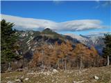
 | Kozarnice - Srednji Golak (unmarked eastern way)
Srednji Golak is located between Mali and Veliki Golak on the plateau of Trnovski gozd above Predmeja. The peak is covered with dwarf pines, and ...
1 h 45 min |
 | Jezero Sobote / Stausee Soboth - Huhnerkogel/Košenjak (on unmarked path)
Košenjak is located north of Dravograd and the Drava River on the border with neighbouring Austria. Access to Košenjak is possible on foot or by ...
1 h 40 min |
 | Avsa - Mrzli vrh (on Matajur)
Mrzli vrh is a 1358-meter-high peak located in the Matajur range. From the summit, where there is a panorama board and a summit register box with...
1 h 25 min |
 | Preval Hlevišče - Mladi vrh
Mladi vrh is the higher neighbor of the better-known Stari vrh, separated from it by a saddle. Covered in sparse beech forest, the summit offers ...
1 h 45 min |
 | Dom Pristava in Javorniški Rovt - Španov vrh
Španov vrh is a 1334-meter-high mountain in the Karavanke that rises between Javorniški Rovt and Planina pod Golico. From the scenic summit, acce...
1 h 30 min |
| Planina pod Golico - Španov vrh
Španov vrh is a 1334-meter-high mountain in the Karavanke that rises between Javorniški Rovt and Planina pod Golico. From the scenic summit, acce...
1 h 15 min |
 | Planina Lom - Kobilja glava
Kobilja glava is a 1,475-meter-high peak located east of Tolmin. From the summit, where a cross stands, there is a beautiful view of Krn, the ran...
1 h 15 min |
 | Korensko sedlo - Jerebikovec/Rawikautz
Jerebikovec is a 1621 m high mountain rising east of Korensko sedlo. From its partly grassy summit, surrounded by forest, there is no view....
1 h 20 min |
 | Koča na Gozdu - Visoki Mavrinc
Visoki Mavrinc (Špica v Sedelcih) is a 1562 m high mountain between Suha, Mala, and Velika Pišnica. From the summit, where a wooden cross and ple...
1 h 15 min |
 | Eko koča Nanos (Lovska koča Vojkovo) - Grmada (Nanos)
Grmada is a 1209-meter peak situated near the edge of the Nanos plateau, northwest of the better-known Pleša (about a 20-minute walk away). Becau...
1 h 45 min |
 | Križovec - Mala Golica
Mala Golica is a less distinct peak located east of Krvavka. From its grassy summit, there is a nice view of the Dravska dolina, Struško, parts o...
1 h 20 min |
 | Makekova Kočna - Visoki vrh above Jezersko
Visoki vrh is a 1459-meter-high mountain in the ridge between Makekovo Kočna and Ravenska Kočna. From the summit, there is a fine view toward Koč...
1 h 30 min |
 | Makekova Kočna - Javornik above Jezersko
Javornik is a forested peak between the valleys of Ravenska Kočna and Makekove Kočna. There is no view from the summit due to the trees, but near...
1 h 45 min |
 | Makekova Kočna - Skubrov vrh
Skubrov vrh is a 1276 m high mountain rising steeply above the Ravenska Kočna valley. The forested summit offers no views....
1 h 10 min |
 | Poden / Bodental - Požgani rob
Požgani rob is a 1,513-meter-high mountain north of Rjavca. The summit is surrounded by forest, so there is no good view from it, but a nice pano...
1 h 10 min |
 | Matevljek - Petelinjek
Petelinjek is a 1212 m high peak located in the Racna gora range. From the summit, where there is a small metal chair, a cairn, and an old ladder...
1 h 15 min |
 | Sele pri Cerkvi / Zell - Pfarre - Mejnik
Mejnik is a 1517-meter-high peak on the Austrian side of the Karawanks, more precisely in a side ridge of Košuta. On the forested summit is a bou...
1 h 55 min |
 | Rotek - Erbelc
Erbelc is a 1,308-meter-high peak that rises steeply above Zgornja Sorica. From the summit, which has a summit logbook, there is a fine view of t...
1 h 15 min |
| Spodnje Danje - Erbelc
Erbelc is a 1,308-meter-high peak that rises steeply above Zgornja Sorica. From the summit, which has a summit logbook, there is a fine view of t...
1 h 15 min |
 | Rotek - Tonderškofel
Tonderškofel is a 1,326-meter-high peak located between Soriška peč and Erbelc. From the partly overgrown summit, which has no marked trail leadi...
1 h 15 min |
| Spodnje Danje - Tonderškofel
Tonderškofel is a 1,326-meter-high peak located between Soriška peč and Erbelc. From the partly overgrown summit, which has no marked trail leadi...
1 h 15 min |
 | Planina pod Golico - Na pečeh at Črni Vrh
Na pečeh is a lesser-known panoramic peak at 1,318 meters above sea level, rising east above the village of Planina pod Golico. Before the Španov...
1 h 5 min |
 | Tolminske Ravne - Javor (above Tolminske Ravne)
Javor is a 1,363-meter-high peak situated between Tolminske Ravne and Grušnica. From the summit, which features a small cross, nice views open up...
1 h 20 min |
 | Pod Debelo glavo - Gradovec
Gradovec is a 1,692-meter-high peak located north of the ridge of Spodnje Bohinjske gore, specifically above the mountain pasture Poljana. From t...
1 h 35 min |
| Pod Debelo glavo (konec ceste) - Gradovec (via hunting cottage)
Gradovec is a 1,692-meter-high peak located north of the ridge of Spodnje Bohinjske gore, specifically above the mountain pasture Poljana. From t...
1 h 50 min |
 | Korensko sedlo - Petelinjek (above Korensko sedlo) (on Austrian side)
Petelinjek is a smaller ridge located west to southwest of Korensko sedlo. The ridge is mostly on the Slovenian side, with only the highest peak ...
1 h 30 min |
 | Polja - Kališje
Kališje is a lesser-known peak in the western part of the Karawanks. From the summit, where transmitters are located, there are some views toward...
1 h 40 min |
 | Ambrož pod Krvavcem - Kržišče (Pokovše)
Kržišče, also known as Pokovše, is a panoramic peak located between the Jezerca pasture, Kriška planina, and Osredek pasture. From the top, there...
1 h 40 min |
 | Bela Peč - Ojstri vrh (above Prevala) (past peak Seduc)
Ojstri vrh is a 1,197-meter-high mountain located between the Seduc peak and Prevala. From the summit, there is a beautiful view of the surroundi...
1 h 30 min |
 | Bela Peč - Ojstri vrh (above Prevala) (via Ovčje jame)
Ojstri vrh is a 1,197-meter-high mountain located between the Seduc peak and Prevala. From the summit, there is a beautiful view of the surroundi...
1 h 45 min |
 | Zatrnik - Turn (above Bohinjska Bela)
Turn is a panoramic and precipitous peak located above Bohinjska Bela. From the summit, there is a nice view of Ratitovec, Jelovica, the Kamnik-S...
1 h 40 min |
 | Topla (Končnik) - Šoparjev vrh
Šoparjev vrh is a 1,524-meter-high mountain located between Olševa and Peca, more precisely on the ridge separating the Koprivna Valley from the ...
1 h 15 min |
| Koprivna (Kumer) - Šoparjev vrh
Šoparjev vrh is a 1,524-meter-high mountain located between Olševa and Peca, more precisely on the ridge separating the Koprivna Valley from the ...
1 h 10 min |
| Pod Peco / Koprein-Petzen - Šoparjev vrh
Šoparjev vrh is a 1,524-meter-high mountain located between Olševa and Peca, more precisely on the ridge separating the Koprivna Valley from the ...
1 h 35 min |
 | Koprivna (Kumer) - Čofatijev vrh (via Šoparjev vrh)
Čofatijev vrh is a panoramic mountain between the Koprivna and Topla valleys. From the top, a beautiful view opens up on the mountains above both...
1 h 45 min |
| Topla (Končnik) - Čofatijev vrh (via Šoparjev vrh)
Čofatijev vrh is a panoramic mountain between the Koprivna and Topla valleys. From the top, a beautiful view opens up on the mountains above both...
1 h 50 min |
 | Šumahovo sedlo - Jesenik (Jesenikov vrh) (via Veliki and Pikov vrh)
Jesenik, also known as Jesenikov vrh, is a 1,199-meter-high forested peak situated between Mežica and Podpeca....
1 h 45 min |
 | Belopeška jezera / Lago di Fusine - Črni vrh / Colrotondo
Črni vrh / Colrotondo is a fairly panoramic peak located west to southwest of the Belopeška jezera lakes. From the summit, which features a hunti...
1 h 40 min |
 | Završnica (Pri žagi) - Tolsti vrh (at Poljška planina) (via saddle Kališča)
Tolsti vrh is a 1,225-meter-high peak located between Završnica Valley and Draga Valley. The summit lies in forest, but a viewpoint just below of...
1 h 25 min |
 | Poden / Bodental - Veliki Rob / Großer Rain
Veliki Rob / Großer Rain is a 1,464-meter-high peak located on the Austrian side of the Karawanks, specifically in the ridge above the Poden / Bo...
1 h 50 min |
 | Poden / Bodental - Veronjak / Hausberg
Veronjak / Hausberg is a 1,348-meter-high peak located above the Poden / Bodental valley on the Austrian side of the Karawanks. From the summit, ...
1 h 20 min |
| Slovenji Plajberk / Windisch Bleiberg - Veronjak / Hausberg (via Veronjak / Hausberg)
Veronjak / Hausberg is a 1,348-meter-high peak located above the Poden / Bodental valley on the Austrian side of the Karawanks. From the summit, ...
1 h 25 min |
 | Zatrnik - Berjanca
Berjanca is a 1,264 m high peak above the namesake mountain pasture. An abandoned ski lift from the former Zatrnik ski area used to reach the sum...
1 h 35 min |
 | Slovenji Plajberk / Windisch Bleiberg - Rabenberg
Rabenberg is a 1,465 m high peak located in the Žingarica / Singerberg ridge. From the summit, there is a partial view to the northwest, while fo...
1 h 45 min |
| Plajberški graben / Bleiberger Graben - Rabenberg
Rabenberg is a 1,465 m high peak located in the Žingarica / Singerberg ridge. From the summit, there is a partial view to the northwest, while fo...
1 h 45 min |
 | Medvodje - Penatca
Penatca is a 1,299-meter-high peak located above the right bank of the Tržiška Bistrica. The summit itself is in the forest, but a few steps to t...
1 h 40 min |
 | Jelendol (mansion Puterhof) - Primožkovi hribi
Primožkovi hribi is a small ridge above Jelendol, situated between the Tržiška Bistrica, Dolžanka and Zalega potok streams. The ridge's highest p...
1 h 40 min |
| MHE Zali potok - Primožkovi hribi
Primožkovi hribi is a small ridge above Jelendol, situated between the Tržiška Bistrica, Dolžanka and Zalega potok streams. The ridge's highest p...
1 h 30 min |
 | Medvodje - Medvodnica (via Tržiška Bistrica)
Medvodnica is a 1,202-meter-high mountain situated between the Košutnik and Tržiška Bistrica streams. The summit lies within the forest, offering...
1 h 30 min |
| Medvodje - Medvodnica (via Košutnik)
Medvodnica is a 1,202-meter-high mountain situated between the Košutnik and Tržiška Bistrica streams. The summit lies within the forest, offering...
1 h 25 min |
 | Erjavčev rovt - Bela peč (above Dovje)
Bela peč is a lesser-known peak located above the marked trail from Dovje to Dovška Baba. From the summit, there is a beautiful view to the south...
1 h 15 min |
 | Teichalm (Teichalmsee) - Zachenkreuz
Zachenkreuz is a 1,601-meter-high peak situated above the Teichalm mountain pasture. On the summit, mostly overgrown by sparse forest, stands a w...
1 h 20 min |
| Breitalm - Zachenkreuz
Zachenkreuz is a 1,601-meter-high peak situated above the Teichalm mountain pasture. On the summit, mostly overgrown by sparse forest, stands a w...
1 h 15 min |
 | Feistritzsattel - Großer Pfaff (easier path)
Großer Pfaff is a 1555-meter-high panoramic peak situated between the Pfaffensattel and Feistritzsattel passes. From the summit, where there is a...
1 h 45 min |
 | Feistritzsattel - Kleiner Pfaff
Kleiner Pfaff is a 1539-meter-high peak located southeast of the Pfaffensattel pass. From the summit, where a small cross stands, beautiful views...
1 h 45 min |
 | Feistritzsattel - Schöberlriegel
Schöberlriegel is a 1,704-meter-high peak situated north of Hochwechsel. From the summit, where a large cairn stands, a beautiful view opens up o...
1 h 40 min |
 | Straßegg - Zechnerschlag (Rohregg)
Zechnerschlag, or Rohregg, is a 1434-meter-high mountain situated in the Almenland nature park. From the summit, where a cross stands, a beautifu...
1 h 30 min |
 | Dražgoše (Na Pečeh) - Britmanca
Britmanca is a 1,231-meter-high peak on the edge of the Jelovica plateau. Slightly south and lower from the summit along a well-worn path lies a ...
1 h 10 min |
 | Brneško sedlo - Mala Kopa
Mala Kopa is a 1,524-meter-high peak in the western part of the Pohorje. From the summit, where part of the Kope ski resort is also located, a be...
1 h 35 min |
| Koča Planinc - Mala Kopa
Mala Kopa is a 1,524-meter-high peak in the western part of the Pohorje. From the summit, where part of the Kope ski resort is also located, a be...
1 h 35 min |