 | Dom na Gospincu - Veliki Zvoh
Veliki Zvoh is the highest point of the Krvavec ski resort. The cable car does not quite reach the summit but stops only a few metres short. A fe...
1 h 25 min |
| Kriška planina - Veliki Zvoh
Veliki Zvoh is the highest point of the Krvavec ski resort. The cable car does not quite reach the summit but stops only a few metres short. A fe...
1 h 25 min |
 | Planina Jezerca - Veliki Zvoh (via Dom na Krvavcu)
Veliki Zvoh is the highest point of the Krvavec ski resort. The cable car does not quite reach the summit but stops only a few metres short. A fe...
1 h 40 min |
 | Pri Rupah - Mrežce (direct way)
Mrežce is a panoramic peak near Lipanski vrh, which is visible on the other side of the gully between the two peaks. Since the slopes towards Pok...
1 h 40 min |
 | Pri Rupah - Lipanski vrh
The panoramic Lipanski vrh is located above the Blejska koča on the Lipanca mountain pasture. From the summit, which drops steeply towards the Kr...
1 h 45 min |
 | Snežniška Grda jama - Veliki Snežnik (via Mali Snežnik)
Veliki Snežnik, at 1796 meters, is the highest peak in the nearby and distant surroundings, offering beautiful views over much of Slovenia and ne...
1 h 25 min |
 | Gašperjev hrib - Veliki Snežnik
Veliki Snežnik, at 1796 meters, is the highest peak in the nearby and distant surroundings, offering beautiful views over much of Slovenia and ne...
1 h 30 min |
 | Gašperjev hrib - Veliki Snežnik
Veliki Snežnik, at 1796 meters, is the highest peak in the nearby and distant surroundings, offering beautiful views over much of Slovenia and ne...
1 h 30 min |
| Sežanje - Veliki Snežnik
Veliki Snežnik, at 1796 meters, is the highest peak in the nearby and distant surroundings, offering beautiful views over much of Slovenia and ne...
1 h 40 min |
 | Bistriška planina - Dobrča
Dobrča is a 1634-metre mountain located between Begunje and Tržič. From the summit, which has a registration box with a stamp, the view opens onl...
1 h 30 min |
 | Snežna jama - Velika Raduha
Velika Raduha, at 2062 m, is the highest peak of the Raduha range, which rises steeply east of Robanov Kot. From the summit, with its registratio...
1 h 45 min |
 | Črni Kal - Blegoš (by road, via hut)
Blegoš is a 1,562-metre-high mountain located between the Selška Sora and Poljanska Sora rivers. From the grassy summit, where there is a stamp a...
1 h 30 min |
 | Črni Kal - Blegoš (direct way)
Blegoš is a 1,562-metre-high mountain located between the Selška Sora and Poljanska Sora rivers. From the grassy summit, where there is a stamp a...
1 h 10 min |
 | Črni kal - Blegoš (via Prva ravan)
Blegoš is a 1,562-metre-high mountain located between the Selška Sora and Poljanska Sora rivers. From the grassy summit, where there is a stamp a...
1 h 20 min |
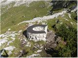
 | Bohinjsko sedlo - Možic (direct way)
Možic is a 1,602 m high peak located west of Soriška Planina. At the very summit there is an old military bunker bearing the name of the peak and...
1 h 15 min |
| Bohinjsko sedlo - Možic (by Lajnar)
Možic is a 1,602 m high peak located west of Soriška Planina. At the very summit there is an old military bunker bearing the name of the peak and...
1 h 30 min |
 | Hunting cottage (Davča) - Porezen
Porezen is a 1,630 m high mountain situated between Davča and Baška Grapa. From the summit, where a large Partisan monument stands, a beautiful v...
1 h 45 min |
 | Podhočar - Porezen
Porezen is a 1,630 m high mountain situated between Davča and Baška Grapa. From the summit, where a large Partisan monument stands, a beautiful v...
1 h 50 min |
 | end of road on Vogar - Pršivec (direct way)
Pršivec is a panoramic mountain above Lake Bohinj. The view is extensive in all directions: Triglav and the surrounding mountains are clearly vis...
1 h 30 min |
 | Planina Dol - Konj
Konj is an 1803 m high peak located between Velika Planina and Presedljaj. From the summit there is a beautiful view of the highest peaks of the ...
1 h 30 min |
 | Tonkina koča na Vršiču - Vršič vrh
Vršič is a 1,737-metre-high mountain situated between the Poštarski dom hut and the Vršič pass. From the summit, where there is a registration bo...
1 h |
 | Bohinjsko sedlo - Dravh (via Lajnar)
Dravh is a 1,547-metre-high peak situated between Sorica and Soriška Planina. From the unforested summit a beautiful view opens across the Škofja...
1 h |
 | Bohinjsko sedlo - Šavnik
Šavnik is a grassy peak situated between the ski resorts of Soriška Planina and Kobla. From the summit, which has a registration box with a stamp...
1 h 30 min |
 | Ski hotel Vogel - Šija
Šija is located above the Vogel ski resort in the Lower Bohinj Mountains. From the summit, there is a nice view of the neighboring peaks in the s...
1 h 30 min |
 | Tonkina koča na Vršiču - Sovna glava (on old road)
Sovna Glava is a 1750-meter-high grassy peak situated between Prisank and the Vršič Pass. From the summit, there is a nice view of the peaks risi...
1 h 10 min |
 | Kramarica - Smrekovec (via Bukov stan)
Smrekovec is a mountain of volcanic origin on the eastern edge of the Smrekovec mountain range. The wide grassy summit features a pyramid with a ...
1 h 30 min |
| Kramarica - Smrekovec (by road)
Smrekovec is a mountain of volcanic origin on the eastern edge of the Smrekovec mountain range. The wide grassy summit features a pyramid with a ...
1 h 30 min |
 | Brneško sedlo - Velika Kopa
Velika Kopa is a 1542-meter-high peak located between Grmovškov dom and the nearby Mala Kopa. From the top, which is only 1 meter lower than the ...
1 h 50 min |
| Koča Planinc - Velika Kopa
Velika Kopa is a 1542-meter-high peak located between Grmovškov dom and the nearby Mala Kopa. From the top, which is only 1 meter lower than the ...
1 h 50 min |
 | Grda draga - Mali Snežnik
Mali Snežnik is a peak on the western ridge of Snežnik. Covered with dwarf pines, the summit offers beautiful views of the neighboring Veliki Sne...
1 h 30 min |
| Sviščaki - Mali Snežnik
Mali Snežnik is a peak on the western ridge of Snežnik. Covered with dwarf pines, the summit offers beautiful views of the neighboring Veliki Sne...
1 h 50 min |
 | Eisenkappler Hutte - Hochobir (Ojstrc)
Ojstrc (Hochobir) is the highest peak of the smaller Obir range. It is located west of Železna Kapla (Eisenkappel) on the Austrian side of the Ka...
1 h 35 min |
 | Koča na Naravskih ledinah - Uršlja gora (Plešivec)
Uršlja gora, or Plešivec, is a panoramic mountain between Slovenj Gradec and Črna na Koroškem. At or just below the summit stands the Church of S...
1 h 45 min |
 | Walischeben - Weißenstein (Packalpe) (Direct way)
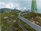
Weißenstein is a grassy mountain crisscrossed with wire fences. From its indistinct summit, there is a nice view of the neighboring Ameringkogel ...
1 h 45 min |
 | Salzstiegelhaus - Hofalmkogel (Packalpe)
Hofalmkogel is a less distinct peak in the ridge from Großenberg to Speikkogel. The summit is broad and mostly grassy. From the top, there is a b...
1 h 50 min |
 | Salzstiegelhaus - Speikkogel (Packalpe)
Speikkogel is a spacious and grassy summit in the Packalpe mountain group. From the top, there is a beautiful view towards the Slovenian mountain...
1 h 15 min |
 | Zadnji travnik - Govca (Olševa)
Govca is the highest peak of the Olševa range, rising above Koprivna, Solčava, and Remšenik (Remšenik/Remschenig is a valley on the Austrian side...
1 h 45 min |
 | Jezerski vrh - Kärntner Storschitz / Pristovški Storžič
Pristovški Storžič (Kärntner Storschitz) is an exceptionally panoramic peak above Jezersko. From it, there are fine views of the northern walls o...
1 h 50 min |
 | Plattner - Gartnerkofel (direct way)
Gartnerkofel is a 2,195-meter-high mountain in the Nassfeld ski area. Its Slovenian name is Krniške skale. From the summit, where a cross stands,...
1 h 15 min |
 | Dolinza Alm/Planina Dolnica - Starhand
Starhand is a panoramic peak in the eastern part of the Carnic Alps near the better-known Ojstrnik. From the top, there are beautiful views of th...
1 h 40 min |
 | Rifugio Pelizzo - Monte Mataiur/Matajur (via Fonte Skrila)
Matajur is a panoramic mountain located on the border between Slovenia and Italy. From the summit there is a beautiful view of Kobariški or Bregi...
1 h 15 min |
 | Strugarjach / Strugarje - Sinacher Gupf / Psinski vrh
Sinski vrh (mostly marked as Psinski vrh on maps) / Sinacher Gupf is a peak north of the main Karawanks ridge, more precisely north of Stol and V...
1 h 30 min |
 | Rosstratte - Dobratsch / Dobrač (by road)
Dobrač, or in German Dobratsch and also known as Villacher Alpen, is a 2166-meter-high mountain situated on the far eastern edge of the Gailtal A...
1 h 20 min |
 | Bistriška planina - Šentanski vrh
Šentanski vrh, located in the Dobrča range just five minutes from the main peak, offers a nice view of the central Karawanks, the Storžič group, ...
1 h 35 min |
 | Smučišče Koralpe (Koralpenparkplatz) - Großer Speikkogel (Koralpe)
Großer Speikkogel is, at 2,140 meters, the highest peak of Golica/Koralpe, a range east of Volšperk/Wolfsberg. From the summit, where a cross and...
1 h 35 min |
 | Atelsko sedlo - Boskovec
Boskovec is with 1587 m the highest peak of the Golte plateau. From the top on which a lookout tower stands, a view opens up on part of Kamnik Sa...
1 h 30 min |
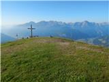
 | Turracher Höhe - Kornock (northern way)
Kornock is a panoramic peak located west of the Turracherhöhe mountain pass. The summit, which is also the highest point of the Turracherhöhe ski...
1 h 15 min |
 | Turracher Höhe - Schoberriegel
Schoberriegel is a 2,208 m high peak located between the Turracher Höhe alpine pass and the slightly higher Gruft. From the summit, where a cross...
1 h 20 min |
 | Turracher Höhe - Gruft
Gruft is a grass-covered peak located southeast of the Turracher Höhe pass in the heart of the Gurktal Alps. From its 2,232 m high summit there a...
1 h 45 min |
 | Planina Jezerca - Krvavec
Krvavec is a 1,853-meter-high peak located in the heart of the eponymous ski resort. From the summit, which is crisscrossed with cable cars, ther...
1 h 10 min |
 | Panoramarestaurant Oben - Končnikov vrh (Peca)
Končnikov vrh (German: Knieps) is a 2109 m high peak situated in the central part of Peca. From the grassy summit, there is a beautiful view of t...
1 h 20 min |
 | Panoramarestaurant Oben - Končnikov vrh (Peca) (past old cotage)
Končnikov vrh (German: Knieps) is a 2109 m high peak situated in the central part of Peca. From the grassy summit, there is a beautiful view of t...
1 h 15 min |
 | Torka - Gladki vrh (Ratitovec)
Gladki vrh (Ratitovec), at 1,667 meters, is the most visited peak in the Ratitovec range. From its bare summit, which features a panorama board, ...
1 h 20 min |
 | Torka - Altemaver (Ratitovec)
Altemaver (Ratitovec), at 1,678 meters, is the highest peak of Ratitovec. From its grassy summit, there is a beautiful view of the Julian Alps, J...
1 h 35 min |
 | Zgornje Danje - Altemaver (Ratitovec)
Altemaver (Ratitovec), at 1,678 meters, is the highest peak of Ratitovec. From its grassy summit, there is a beautiful view of the Julian Alps, J...
1 h 45 min |
 | Pod Peco/Koprein-Petzen - Topitza
Topica, or Topitza in German, is a 1649-meter-high peak situated northeast of Železna Kapla. From the summit, where a cross stands, a nice view o...
1 h 15 min |
 | Rifugio Selvapiana I.Lunelli - Belvedere (Creston Popera)
Belvedere is a 2,125-meter peak on the slopes of the Creston Popera ridge, a known battlefield from World War I. The summit features a stone semi...
1 h 40 min |
 | Zgornje Danje - Kremant (Ratitovec)
Kremant is a 1,654 m high peak located on the western part of Ratitovec. From the summit, where a stamp is attached to a metal pole, a nice view ...
1 h 45 min |
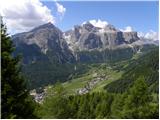 | Colfosco - Rifugio Col Pradat (by road)
The Rifugio Col Pradat mountain hut is situated at 2038 meters in the Puez mountain group. Due to its proximity to the ski area, the hut is well ...
1 h |
 | Weinebene Straße - Weberkogel
Weberkogel is a less prominent peak located north to northwest of the alpine pass Weinebene. On the 1805-meter-high summit stands a medium-sized ...
1 h 30 min |
| Gasthof Pfeifferstocker - Weberkogel
Weberkogel is a less prominent peak located north to northwest of the alpine pass Weinebene. On the 1805-meter-high summit stands a medium-sized ...
1 h 50 min |
 | Glashütten (Gasthof Almwirt) - Glashüttenkogel
Glashüttenkogel is a 1762-meter-high peak located west to northwest of Lonč / Deutschlandsberg. From the grassy summit, there is a fine view towa...
1 h 25 min |
 | Zettersfeld - Steinermandl
Steinermandl is a 2,235-meter-high peak in the Schober mountain group. Below the summit there is also a hut and the upper chairlift station. From...
1 h |
 | Iličev rovt / Illitsch Rauth - Kamnica (Komnica) / Ferlacher Spitze
Kamnica is a panoramic mountain on the Austrian side of the Karawanks, more precisely north of Kepa. From the summit, which has a cross, summit r...
1 h 35 min |
 | Bodenbauer - Kosmatica / Kosmatitza
Kosmatica / Kosmatitza is a 1,659-meter-high peak entirely on the Austrian side of the Karawanks, north of Vrtača. From the summit, which is part...
1 h 45 min |
 | Klippitztörl - Forstalpe (Saualpe)
Forstalpe is an indistinct peak in the massif of Svinška planina / Saualpe. The stamp for Forstalpe is located in an interesting natural window, ...
1 h 40 min |
 | Wiesser Alm - Mirnock (Path 184)
Mirnock is a 2,110 m high isolated and highly panoramic mountain massif in Carinthia. It is part of the Nockberge group in the Gurktal Alps, loca...
1 h 30 min |
 | parking below Weinebene - Steinmandl (Golica / Koralpe) (via Grünangerhütte)
Steinmandl is a panoramic peak in the Golica/Koralpe range, where numerous stone cairns have been built....
1 h 40 min |
 | Knödelhütte - Hirschegger Alm (southern peak)
The southern peak in the Hirschegger Alm ridge is located west of the settlement of Hirschegg. From the summit, where a cross stands, a beautiful...
1 h 35 min |
| Unterauerlinger Hütte - Hirschegger Alm (southern peak)
The southern peak in the Hirschegger Alm ridge is located west of the settlement of Hirschegg. From the summit, where a cross stands, a beautiful...
1 h 25 min |
 | Salzstiegelhaus - Peterer Riegel
Peterer Riegel is a panoramic peak above the Peterer Sattel saddle. From the summit, where a cross stands and a bench sits below it, a beautiful ...
1 h 45 min |
 | Smučišče Koralpe (Koralpenparkplatz) - Steinschneider (by the edge of the Großes Kar plateau)
Steinschneider is a 2070-meter-high peak in the Golica / Koralpe mountain range, situated northwest of Großer Speikkogel, the highest peak of the...
1 h 50 min |
| Koralpe Ski Resort (Koralpenparkplatz) - Steinschneider
Steinschneider is a 2070-meter-high peak in the Golica / Koralpe mountain range, situated northwest of Großer Speikkogel, the highest peak of the...
1 h 20 min |
 | Teichalm (Angerwirt) - Osser
Osser is a 1548-meter-high peak situated above the Teichalm plateau. From the summit, where a cross stands, a beautiful view opens up over the su...
1 h 20 min |
 | Teichalm (Harrerhütte) - Osser
Osser is a 1548-meter-high peak situated above the Teichalm plateau. From the summit, where a cross stands, a beautiful view opens up over the su...
1 h 35 min |
 | Straßegg - Hochschlag
Hochschlag is a 1580-meter-high panoramic peak located in the Fischbacher Alpen mountain group. From the summit, where a cross and a summit regis...
1 h 45 min |
 | Nassfeld - Javornik / Auernig (via Auernig Alm)
Javornik (Italian Monte Auernig, German Auernig) is a 1864-meter-high peak above Mokrine on the border between Austria and Italy. The summit, cov...
1 h 35 min |
 | Nassfeld - Garnitzenberg / Monte Carnizza (via Auernig Alm)
Krniška gora (Italian Monte Carnizza, German Garnitzenberg) is a 1950-meter-high mountain east of the Mokrine mountain pass. It is located on the...
1 h 50 min |
 | Kohlebnerstand - Windberg (northern path)
Windberg is a 1903-meter-high peak in the Schneealpe mountain group and, with its elevation, the highest peak of the group. From the summit, wher...
1 h 50 min |
| Kohlebnerstand - Windberg (southern path)
Windberg is a 1903-meter-high peak in the Schneealpe mountain group and, with its elevation, the highest peak of the group. From the summit, wher...
1 h 50 min |
 | Kohlebnerstand - Hoher Klapf
Hoher Klapf is a panoramic pathless peak in the Schneealpe mountain group, located near the group's highest peak, Windberg....
1 h 40 min |
 | Panoramarestaurant Oben - Križnik (Peca)
Križnik is a 2,109-meter-high peak on Peca, located on the Austrian side of the mountain. From the summit, just a short way above the marked path...
1 h 40 min |
 | Seebergsattel - Seeleiten
Seeleiten is a panoramic peak with a cross on the Aflenzer Staritzen ridge, which belongs to the Hochschwab mountain group....
1 h 30 min |