 | Povodje - Šmarna gora
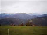
Šmarna gora is a 669 m peak northwest of Slovenia's capital. From the summit, with its restaurant and church, there is a beautiful view over Gore...
1 h 30 min |
 | Povodje - Šmarna gora (via Sedlo)
Šmarna gora is a 669 m peak northwest of Slovenia's capital. From the summit, with its restaurant and church, there is a beautiful view over Gore...
1 h 35 min |
| Šmartno - Šmarna gora (path around Šmarna gora)
Šmarna gora is a 669 m peak northwest of Slovenia's capital. From the summit, with its restaurant and church, there is a beautiful view over Gore...
1 h 30 min |
 | Povodje - Šmarna gora (Partizanska steza)
Šmarna gora is a 669 m peak northwest of Slovenia's capital. From the summit, with its restaurant and church, there is a beautiful view over Gore...
1 h 45 min |
 | Vikrče - Šmarna gora (Mazijeva steza)
Šmarna gora is a 669 m peak northwest of Slovenia's capital. From the summit, with its restaurant and church, there is a beautiful view over Gore...
1 h 35 min |
 | Vikrče - Šmarna gora (learning trail)
Šmarna gora is a 669 m peak northwest of Slovenia's capital. From the summit, with its restaurant and church, there is a beautiful view over Gore...
1 h 20 min |
 | Povodje - Rašica (Vrh Staneta Kosca)
Vrh Staneta Kosca, better known as Rašica, is located north of Ljubljana, more precisely above the villages of Rašica and Dobeno. From the summit...
1 h 30 min |
 | Jablje Castle - Rašica (Vrh Staneta Kosca)
Vrh Staneta Kosca, better known as Rašica, is located north of Ljubljana, more precisely above the villages of Rašica and Dobeno. From the summit...
1 h 20 min |
| Loka - Rašica (Vrh Staneta Kosca)
Vrh Staneta Kosca, better known as Rašica, is located north of Ljubljana, more precisely above the villages of Rašica and Dobeno. From the summit...
1 h 20 min |
 | Ljubljana (Šentvid) - Toško Čelo
Toško Čelo is a 590-metre hill above the village of the same name. From the summit, or slightly below it, a beautiful view opens over part of Lju...
1 h 45 min |
 | Grgar - Sveta Gora (via Frančiškov hrib)
Sveta Gora is known mainly among believers and locals. It is a well-known pilgrimage center above Nova Gorica. Believers come here from all over ...
1 h 25 min |
 | Grgar - Sveta Gora (via Po sredi)
Sveta Gora is known mainly among believers and locals. It is a well-known pilgrimage center above Nova Gorica. Believers come here from all over ...
1 h 15 min |
| Grgar - Sveta Gora (via Ranjeke)
Sveta Gora is known mainly among believers and locals. It is a well-known pilgrimage center above Nova Gorica. Believers come here from all over ...
1 h 30 min |
 | Grgar - Sveta Gora (via Križce)
Sveta Gora is known mainly among believers and locals. It is a well-known pilgrimage center above Nova Gorica. Believers come here from all over ...
1 h 30 min |
 | Povodje - Grmada
Grmada is a 676-meter-high mountain located west of the much more visited Šmarna gora. From the summit, which has a small takeoff area, a beautif...
1 h 50 min |
| Vikrče - Grmada (via Zatrep)
Grmada is a 676-meter-high mountain located west of the much more visited Šmarna gora. From the summit, which has a small takeoff area, a beautif...
1 h 15 min |
| Vikrče - Grmada (on Kovačeva steza and over Sedlo)
Grmada is a 676-meter-high mountain located west of the much more visited Šmarna gora. From the summit, which has a small takeoff area, a beautif...
1 h 15 min |
| Vikrče - Grmada (learning trail)
Grmada is a 676-meter-high mountain located west of the much more visited Šmarna gora. From the summit, which has a small takeoff area, a beautif...
1 h 20 min |
 | Za koridorjem - Sabotin (on ridge)
Sabotin is a hill above Nova Gorica or, more precisely, above Solkan. Despite its modest height, it is an excellent viewpoint with views of the J...
1 h 15 min |
 | Jevnica - Janče
Janče is a 792-meter-high peak situated between the Sava River and the Besnica stream valley. From the summit, where a mountain hut stands and th...
1 h 45 min |
 | Laze pri Dolskem - Janče
Janče is a 792-meter-high peak situated between the Sava River and the Besnica stream valley. From the summit, where a mountain hut stands and th...
2 h 15 min |
 | Senožeti - Sveti Miklavž above Sava (footpath)
The Church of St. Miklavž is situated on a panoramic hill south of Moravče. From the summit, there is a beautiful view toward the nearby Limbarsk...
1 h 20 min |
 | Kamnica - Sveti Miklavž above Sava (via Velika vas)
The Church of St. Miklavž is situated on a panoramic hill south of Moravče. From the summit, there is a beautiful view toward the nearby Limbarsk...
2 h 5 min |
 | Senožeti - Cicelj
Cicelj is a forest-covered peak located between Moravče and the village of Senožeti. From the summit, which has a bench and a logbook box, there ...
1 h 30 min |
 | Kamnica - Cicelj (via farm Buven)
Cicelj is a forest-covered peak located between Moravče and the village of Senožeti. From the summit, which has a bench and a logbook box, there ...
1 h 45 min |
 | Kamnica - Cicelj
Cicelj is a forest-covered peak located between Moravče and the village of Senožeti. From the summit, which has a bench and a logbook box, there ...
1 h 40 min |
 | Senožeti - Cicelj (hunting path)
Cicelj is a forest-covered peak located between Moravče and the village of Senožeti. From the summit, which has a bench and a logbook box, there ...
1 h 30 min |
 | Breg - Sveti Lovrenc (above Okroglice)
The Church of St. Lovrenc is located east of Zidani Most and northwest of Sevnica, above the village of Okroglice and near the Lovrenc peak. From...
1 h 45 min |
 | Hrastnik - Dom v Gorah
The Dom v Gorah mountain hut is located east of Hrastnik, just a few meters below the 786 m high peak where the church of St. Jurij stands. From ...
1 h 30 min |
 | Rečica ob Paki - Gora Oljka
Gora Oljka is a hill located east of Šmartno ob Paki. On the summit stands the Church of the Holy Cross, built in the mid-18th century. Just a fe...
1 h 15 min |
 | Podgora - Gora Oljka (Martin way)
Gora Oljka is a hill located east of Šmartno ob Paki. On the summit stands the Church of the Holy Cross, built in the mid-18th century. Just a fe...
1 h 20 min |
 | Polzela - Gora Oljka (via Vimperk)
Gora Oljka is a hill located east of Šmartno ob Paki. On the summit stands the Church of the Holy Cross, built in the mid-18th century. Just a fe...
2 h 15 min |
 | Prebold - Golava
Golava is a peak located north of Mrzlica. From the summit, where there is a small bivouac (Blažev bivak), there is a fine view toward the aforem...
1 h 45 min |
 | Spodnja Rečica - Dom na Šmohorju (via Tolsto)
The mountain hut Dom na Šmohorju is located between Laško, Liboje, and Zabukovica. From the hut, or from the church of St. Mohor just a few minut...
1 h 35 min |
| Laško - Dom na Šmohorju
The mountain hut Dom na Šmohorju is located between Laško, Liboje, and Zabukovica. From the hut, or from the church of St. Mohor just a few minut...
2 h |
 | Gradišče - Gradiška Tura (via Plaz)
Gradiška Tura is a peak on the western side of the Nanoška planota plateau. A well-routed climbing path and some easier trails lead to the top, f...
2 h |
 | Grgar - Vodice (via Ranjeke)
Vodice (according to some records also Sveti Jakob) is a peak on the western part of the Banjška planota plateau. From the summit, which features...
1 h 30 min |
 | Tremerje - Veliki Slomnik (Tremerje - Veliki Slomnik - Liboje)
Veliki Slomnik is a peak located between Košnica pri Celju and Liboje. The summit has a logbook box, but due to the surrounding forest, there are...
1 h 35 min |
 | Šentjur - Resevna
Resevna is a peak situated south of Šentjur. At the summit stands a 20-meter-high observation tower offering beautiful views that extend far acro...
1 h 30 min |
| Jakob pri Šentjurju - Resevna
Resevna is a peak situated south of Šentjur. At the summit stands a 20-meter-high observation tower offering beautiful views that extend far acro...
1 h 30 min |
 | Šentjur (center) - Resevna (via Krajnče)
Resevna is a peak situated south of Šentjur. At the summit stands a 20-meter-high observation tower offering beautiful views that extend far acro...
1 h 35 min |
| Šentjur (center) - Resevna (steep path)
Resevna is a peak situated south of Šentjur. At the summit stands a 20-meter-high observation tower offering beautiful views that extend far acro...
1 h 30 min |
| Šentjur (center) - Resevna (gentle path)
Resevna is a peak situated south of Šentjur. At the summit stands a 20-meter-high observation tower offering beautiful views that extend far acro...
1 h 35 min |
 | Gorica pri Slivnici - Rifnik
Rifnik is a 568-meter-high peak situated south of Šentjur pri Celju. The summit, known for its archaeological site, offers nice views towards Šen...
1 h 15 min |
 | Zagrad - Grmada above Celje (gentle path)
What Šmarna gora is to people from Ljubljana, Grmada is to those from Celje. Celje's local mountain lies south of the town above Zagrad village. ...
1 h 30 min |
 | Zvodno - Grmada above Celje (via Suhi potok)
What Šmarna gora is to people from Ljubljana, Grmada is to those from Celje. Celje's local mountain lies south of the town above Zagrad village. ...
1 h 15 min |
 | Zagrad - Tolsti vrh above Celjska koča (Po vrheh)
Tolsti vrh (also recorded as Tovsti vrh in some sources) is situated above the Celjska koča ski area. The summit has a logbook box and stamp, but...
1 h 40 min |
 | Hayrack (Laška vas - Pečovje) - Tolsti vrh above Celjska koča (via chapel at Mary and on CPP)
Tolsti vrh (also recorded as Tovsti vrh in some sources) is situated above the Celjska koča ski area. The summit has a logbook box and stamp, but...
1 h 35 min |
 | Zvodno - Tolsti vrh above Celjska koča (via Suhi potok)
Tolsti vrh (also recorded as Tovsti vrh in some sources) is situated above the Celjska koča ski area. The summit has a logbook box and stamp, but...
1 h 30 min |
 | Zvodno - Tolsti vrh above Celjska koča (via Marija)
Tolsti vrh (also recorded as Tovsti vrh in some sources) is situated above the Celjska koča ski area. The summit has a logbook box and stamp, but...
1 h 40 min |
 | Zvodno - Tolsti vrh above Celjska koča (via Suhi potok and on ski slope)
Tolsti vrh (also recorded as Tovsti vrh in some sources) is situated above the Celjska koča ski area. The summit has a logbook box and stamp, but...
1 h 30 min |
 | Štore - Srebotnik
Srebotnik is a slightly vegetated peak located south of Celje and Štore in the Posavsko hribovje. The summit, which has a logbook box and a small...
1 h 30 min |
 | Štore - Srebotnik (via Marija and south approach)
Srebotnik is a slightly vegetated peak located south of Celje and Štore in the Posavsko hribovje. The summit, which has a logbook box and a small...
1 h 45 min |
 | Zvodno - Srebotnik (on Celje mountain trail)
Srebotnik is a slightly vegetated peak located south of Celje and Štore in the Posavsko hribovje. The summit, which has a logbook box and a small...
1 h 15 min |
 | Teharje - Srebotnik (Pot I. Celjske čete)
Srebotnik is a slightly vegetated peak located south of Celje and Štore in the Posavsko hribovje. The summit, which has a logbook box and a small...
2 h |
 | Lopata - Planinski dom Šentjungert
The mountain hut is located just a few meters below the summit of Gora, where the Church of St. Kunigunda stands; it was built in the 14th centur...
1 h 30 min |
 | Bresternica (Šoberjev dvor) - Tojzlov vrh
Tojzlov vrh is a forested hill on the eastern part of Kozjak. On the summit stands a small stone NOB monument and, more recently, also a summit l...
1 h 15 min |
 | Kozjak nad Pesnico - Tojzlov vrh
Tojzlov vrh is a forested hill on the eastern part of Kozjak. On the summit stands a small stone NOB monument and, more recently, also a summit l...
2 h 5 min |
 | Kamnica - Murovica
Murovica is a popular excursion point, accessible from the Posavje side, Domžale, or the Moravška Valley. On the summit there is a bench and a lo...
1 h 20 min |
| Senožeti - Murovica (via Vrh pri Dolskem)
Murovica is a popular excursion point, accessible from the Posavje side, Domžale, or the Moravška Valley. On the summit there is a bench and a lo...
2 h 5 min |
| Senožeti - Murovica (via farm Buven)
Murovica is a popular excursion point, accessible from the Posavje side, Domžale, or the Moravška Valley. On the summit there is a bench and a lo...
1 h 55 min |
 | Bistra - Mali Trebelnik
Mali Trebelnik is an 807-meter-high hill rising above the southwestern part of the Ljubljana Marshes. From the partly grassy summit, which is par...
1 h 45 min |
 | Spodnja Rečica - Tolsto
Tolsto is a 780-meter-high hill between Huda Jama and Šmohor. The summit has a logbook and stamp box, but offers no view due to the forest....
1 h 15 min |
 | Reka - Rodne
Rodne is a 698-meter-high peak situated west of Orehovška Grapa. From the grassy summit, a nice view opens up towards the Cerkljansko-Idrijsko hi...
1 h 20 min |
 | Seljanec - Ham (via Seljanečki potok)
Ham is an isolated peak beside the Ivanščica range, above the Bednja river valley. It is separated from Ivanščica by the Železnice stream valley,...
1 h 30 min |
 | Grgar - Frančiškov hrib
Frančiškov hrib is a less prominent peak on Skalnica, whose highest point is the 681-meter-high Sveta Gora. From the panoramic summit, which feat...
1 h 15 min |
 | Dobrnič - Trebni vrh (via Šahovec)
Trebni vrh is a 581-meter-high hill located south or southwest of Trebnje. On the forested summit stands a bench, and nearby is a logbook box wit...
1 h 45 min |
 | Lesično - Brest (Bohor)
Brest is a peak on Bohor, though it resembles more of a saddle. It is an important trail junction on Bohor, lying between more easterly Oslica an...
1 h 30 min |
 | Kozje - Brest (Bohor) (via Vetrnik)
Brest is a peak on Bohor, though it resembles more of a saddle. It is an important trail junction on Bohor, lying between more easterly Oslica an...
2 h |
 | Kozje - Raskože (Bohor) (via Vetrnik)
Raskože is a 650-meter-high peak on the eastern part of Bohor. Some people also call this area Vetrnik. The south side of the peak is dominated b...
1 h 15 min |
 | Kozje - Pokojni vrh (Bohor) (via Vetrnik)
Pokojni vrh is on the eastern part of Bohor. The western part features a pasture, the rest mostly forest. There is no summit logbook. From the to...
1 h 30 min |
| Tourist farm Žurej - Žusem (Panoramska pot - old route)
Žusem is a 669-meter-high hill with a rich history and great potential for the future. It forms the northern edge of Kozjansko, and its name deri...
1 h 40 min |
 | Tourist farm Žurej - Žusem (Panoramska pot)
Žusem is a 669-meter-high hill with a rich history and great potential for the future. It forms the northern edge of Kozjansko, and its name deri...
1 h 40 min |
 | Loka pri Žusmu (Žamerk) - Žusem
Žusem is a 669-meter-high hill with a rich history and great potential for the future. It forms the northern edge of Kozjansko, and its name deri...
1 h 20 min |
 | Loka pri Žusmu (Žamerk) - Žusem (via Dobrina)
Žusem is a 669-meter-high hill with a rich history and great potential for the future. It forms the northern edge of Kozjansko, and its name deri...
1 h 30 min |
| Krka - Ciganov vrh (Korinjski hrib) (part of circular path Prijetno domače)
Ciganov vrh (Korinjski hrib) is a smaller hill rising above the Krka River valley, from which opens a view (occasionally obscured by vegetation) ...
1 h 45 min |
 | Studenice - Plešivec (at Boč)
Peace, silence, varied terrain... these are characteristics of the peak at the crossroads of numerous paths between the Maribor, Celje, and Ptuj ...
2 h |
 | Studenice - Plešivec (at Boč) (final part on forest road)
Peace, silence, varied terrain... these are characteristics of the peak at the crossroads of numerous paths between the Maribor, Celje, and Ptuj ...
2 h |
 | Bridge over Dušica - Bajturn (Zaplaški hrib) (on north slope)
Bajturn, or Zaplaški hrib, at 609 meters, is the highest peak in the Trebnje municipality. The summit features a pleasant bench with a table, a b...
1 h 30 min |
| Okrog (Lazar) - Bajturn (Zaplaški hrib) (on ridge)
Bajturn, or Zaplaški hrib, at 609 meters, is the highest peak in the Trebnje municipality. The summit features a pleasant bench with a table, a b...
1 h 30 min |
| Okrog (Lazar) - Bajturn (Zaplaški hrib) (on north slope)
Bajturn, or Zaplaški hrib, at 609 meters, is the highest peak in the Trebnje municipality. The summit features a pleasant bench with a table, a b...
1 h 40 min |
 | Bad Gleichenberg (Sägewerk Weiss) - Stradner Kogel
Stradner Kogel is the highest hill in southeastern Styria, Austria. The hill is of volcanic origin, and the summit offers no views in any directi...
1 h 15 min |
 | Naraplje - Jelovice
Jelovice, at 623 meters, is the highest peak in the Haloze hills. The summit is accessible from several directions. It offers partial views towar...
1 h 40 min |
| Stogovci (Vabča vas) - Jelovice
Jelovice, at 623 meters, is the highest peak in the Haloze hills. The summit is accessible from several directions. It offers partial views towar...
1 h 40 min |
 | Gradišče - Škavnica
Škavnica is a 734-meter-high peak above Vipava. From the summit, which features a small cross and bench, there are excellent views of the Vipava ...
1 h 15 min |
 | Railway station (Most na Soči) - Viewpoint Široko
The viewpoint lies at 755 m above Most na Soči in the namesake hamlet of Tolminski Lom. Access is possible by car to the nearby tourist farm or o...
1 h 40 min |
 | Stogovci (Vabča vas) - Kerješetov vrh
Kerješetov vrh is a 590-meter-high hill located above the settlement of Jelovice. The summit is overgrown with forest, so there is no good view f...
1 h 30 min |
 | Brezno - Sveti Jurij (Remšnik) (along Remšniški potok)
The Church of St. Jurij is located on a panoramic hill in the Remšnik settlement, which lies on the slopes of Kozjak. Opposite the church, next t...
1 h 35 min |
 | Radoboj - Sekolje (Strahinjčica)
Sekolje is the easternmost peak of Strahinjčica. It appears as an interesting cone shape from the surrounding areas. The view from the peak is li...
1 h 30 min |
 | Rimske Toplice - Stražnik (via Borovo)
Stražnik is a 648-meter peak south of Rimske Toplice. The summit features a bench and summit register box, with a cross erected in 2021 about 50 ...
1 h 20 min |
 | Podčetrtek (Terme Olimia) - Zavetišče Šmarnica on Mala Rudnica (past castle Podčetrtek)
The Šmarnica shrine is located on Mala Rudnica within the Rudnica range, a smaller hill chain above Podčetrtek. From the shrine there opens a bea...
1 h 15 min |
 | Olimje - Zavetišče Šmarnica on Mala Rudnica
The Šmarnica shrine is located on Mala Rudnica within the Rudnica range, a smaller hill chain above Podčetrtek. From the shrine there opens a bea...
1 h 45 min |
| Slake (Church of the Virgin Mary on Pesek) - Zavetišče Šmarnica on Mala Rudnica
The Šmarnica shrine is located on Mala Rudnica within the Rudnica range, a smaller hill chain above Podčetrtek. From the shrine there opens a bea...
1 h 35 min |
 | Podčetrtek (Terme Olimia) - Silavec (The Tower of Health and Joy on Rudnica) (past castle Podčetrtek)
Silavec is a 622-meter-high peak on Rudnica above Podčetrtek, on which stands a lookout tower slightly over 35 meters tall, offering a beautiful ...
1 h 35 min |
| Podčetrtek (sveti Lovrenc) - Silavec (The Tower of Health and Joy on Rudnica) (past castle Podčetrtek)
Silavec is a 622-meter-high peak on Rudnica above Podčetrtek, on which stands a lookout tower slightly over 35 meters tall, offering a beautiful ...
1 h 25 min |
| Podčetrtek (sveti Lovrenc) - Silavec (The Tower of Health and Joy on Rudnica) (easier path)
Silavec is a 622-meter-high peak on Rudnica above Podčetrtek, on which stands a lookout tower slightly over 35 meters tall, offering a beautiful ...
1 h 15 min |
| Podčetrtek (sveti Lovrenc) - Silavec (The Tower of Health and Joy on Rudnica) (harder path)
Silavec is a 622-meter-high peak on Rudnica above Podčetrtek, on which stands a lookout tower slightly over 35 meters tall, offering a beautiful ...
1 h 15 min |
| Spodnje Tinsko - Silavec (The Tower of Health and Joy on Rudnica)
Silavec is a 622-meter-high peak on Rudnica above Podčetrtek, on which stands a lookout tower slightly over 35 meters tall, offering a beautiful ...
1 h 20 min |
| Olimje - Silavec (The Tower of Health and Joy on Rudnica) (past Koča pri čarovnici)
Silavec is a 622-meter-high peak on Rudnica above Podčetrtek, on which stands a lookout tower slightly over 35 meters tall, offering a beautiful ...
1 h 45 min |
| Olimje - Silavec (The Tower of Health and Joy on Rudnica) (harder path)
Silavec is a 622-meter-high peak on Rudnica above Podčetrtek, on which stands a lookout tower slightly over 35 meters tall, offering a beautiful ...
1 h 35 min |
| Olimje - Silavec (The Tower of Health and Joy on Rudnica) (easier path)
Silavec is a 622-meter-high peak on Rudnica above Podčetrtek, on which stands a lookout tower slightly over 35 meters tall, offering a beautiful ...
1 h 35 min |
| Slake (Church of the Virgin Mary on Pesek) - Silavec (The Tower of Health and Joy on Rudnica) (harder path)
Silavec is a 622-meter-high peak on Rudnica above Podčetrtek, on which stands a lookout tower slightly over 35 meters tall, offering a beautiful ...
1 h 25 min |
| Slake (Church of the Virgin Mary on Pesek) - Silavec (The Tower of Health and Joy on Rudnica) (easier path)
Silavec is a 622-meter-high peak on Rudnica above Podčetrtek, on which stands a lookout tower slightly over 35 meters tall, offering a beautiful ...
1 h 25 min |
 | Zgornje Poljčane - Rančka
Rančka is a 615-meter-high peak located west to southwest of Boč. Just below the summit is a stamp box with a bench nearby; the highest point its...
1 h 25 min |
 | Spodnje Tinsko - Plešivec (Rudnica)
Plešivec is a forest-covered peak on Rudnica, its highest point. The summit has a summit register box, a bench, and a table....
1 h 45 min |
| Olimje - Plešivec (Rudnica) (past lake Zmajevo jezero)
Plešivec is a forest-covered peak on Rudnica, its highest point. The summit has a summit register box, a bench, and a table....
1 h 50 min |
| Olimje - Plešivec (Rudnica)
Plešivec is a forest-covered peak on Rudnica, its highest point. The summit has a summit register box, a bench, and a table....
1 h 30 min |
| Slake (Church of the Virgin Mary on Pesek) - Plešivec (Rudnica)
Plešivec is a forest-covered peak on Rudnica, its highest point. The summit has a summit register box, a bench, and a table....
2 h |
| Podčetrtek (sveti Lovrenc) - Plešivec (Rudnica)
Plešivec is a forest-covered peak on Rudnica, its highest point. The summit has a summit register box, a bench, and a table....
1 h 50 min |
| Podčetrtek (Terme Olimia) - Plešivec (Rudnica) (past castle Podčetrtek)
Plešivec is a forest-covered peak on Rudnica, its highest point. The summit has a summit register box, a bench, and a table....
2 h 5 min |
 | Loka pri Žusmu (Žamerk) - Plešivec (Rudnica)
Plešivec is a forest-covered peak on Rudnica, its highest point. The summit has a summit register box, a bench, and a table....
2 h |
 | Prebold - Tolsti vrh (above Prebold)
Tolsti vrh is a 756-meter-high mountain located southwest of Prebold. From the summit, where a logbook is located, there are partial views toward...
1 h 25 min |
 | Rukavac - Orjak (above Opatija) (direct way)
Orjak is a 722-meter-high peak above Opatija. The rocky summit features two stamps and a logbook. From the top, there are views of Opatija and pa...
1 h 30 min |
 | Stojdraga (Glažuta) - Gradina Tuščak (via Tuščak)
Gradina Tuščak is an HPO point about 10 minutes off the Tuščak summit. The castle is believed to have been built at the end of the 12th or beginn...
1 h 20 min |