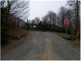
 | Polhov Gradec - Polhograjska Grmada (via Ravnek and via Sveta Uršula)
Polhograjska Grmada is an 898 m high peak located in the heart of the Polhograjski Dolomites. From the summit, where there is a registration box ...
1 h 50 min |
 | Rakovnik - Sveti Jakob (via Breznik)
The Church of St. James is located on a scenic hill north of the village of Topol pri Medvodah. From the summit, which features a registration bo...
1 h 50 min |
 | Gosteče - Osolnik (via Vidmovec)
Osolnik is an 858-metre-high mountain located south of Škofja Loka and west of Medvode. From the summit, where the Church of St Mohor and Fortuna...
1 h 30 min |
 | Hosta - Osolnik
Osolnik is an 858-metre-high mountain located south of Škofja Loka and west of Medvode. From the summit, where the Church of St Mohor and Fortuna...
2 h 10 min |
 | Sveta Barbara (Nova Hrastnica) - Osolnik
Osolnik is an 858-metre-high mountain located south of Škofja Loka and west of Medvode. From the summit, where the Church of St Mohor and Fortuna...
1 h 50 min |
 | Mlinše - Zasavska Sveta gora
Zasavska Sveta Gora is a popular excursion destination located between Litija and Izlake. From the summit, where the parish church of the Nativit...
1 h 30 min |
 | Selski most - Babji zob
Babji zob is a viewpoint above the village of Kupljenik near Bled. The precipitous peak, which has a registration box, offers a beautiful view of...
2 h 30 min |
 | Sveta Barbara (Nova Hrastnica) - Sveti Ožbolt (above Zminec)
Sveti Ožbolt is situated on a panoramic rise in the north of the Polhograjski Dolomiti. There is a beautiful view toward the Škofjeloško hribovje...
1 h 40 min |
 | Dorfarje - Archangel Gabriel (Planica)
Planica is an 824-meter-high peak located north of Škofja Loka, more precisely between Križna gora and Planica. From the summit, where the church...
2 h |
| Vešter - Archangel Gabriel (Planica)
Planica is an 824-meter-high peak located north of Škofja Loka, more precisely between Križna gora and Planica. From the summit, where the church...
2 h 20 min |
 | Hotovlja - Bukov vrh (by road)
Bukov vrh, where the Church of Our Lady of Sorrows stands, is located in the northwestern part of Polhograjsko hribovje. From the summit, there a...
1 h 30 min |
 | Planina - Petričev hrib
Petričev hrib is a peak north of Postojna and west of Planina. From the summit, which has a logbook box, there is a nice view of the Notranjska h...
1 h 30 min |
| Planina (Dolnja Planina) - Petričev hrib (via Zavrtniki)
Petričev hrib is a peak north of Postojna and west of Planina. From the summit, which has a logbook box, there is a nice view of the Notranjska h...
1 h 35 min |
| Planina (Dolnja Planina) - Petričev hrib (via Sv. Duh)
Petričev hrib is a peak north of Postojna and west of Planina. From the summit, which has a logbook box, there is a nice view of the Notranjska h...
1 h 35 min |
 | Stara baba - Sinji vrh
Sinji vrh is a panoramic mountain between Col, Ajdovščina, and Predmeja. It offers views across much of western Slovenia (the sea on clear days)....
1 h 45 min |
 | Divje jezero - Hleviška planina (via Strug)
Hleviška planina (also Hleviške planine) is a slightly vegetated but still very panoramic peak. From the summit, the home mountain of Idrija, the...
1 h 45 min |
 | Spodnje Stranice (graves of hundred hostages) - Stolpnik (by road)
Stolpnik, at 1012 meters, is the highest peak of Konjiška gora, a range stretching southwest from Slovenske Konjice. A 25-meter-high observation ...
2 h |
 | Jablance - Skalica (Bohor) (via Travni laz)
Skalica is a lesser-known peak on the western part of Bohor. From the summit, which has a logbook box, there is a nice view to the south and west...
2 h |
 | Jablance - Veliki Javornik (Bohor) (via Travni laz)
Veliki Javornik, at 1023 meters, is the highest peak of Bohor. Although the summit is unvegetated and there are no higher hills nearby, there is ...
1 h 40 min |
 | Selca - Miklavška gora (by road)
Miklavška gora is a panoramic hill situated south of Železniki and Selca. From the summit, where the Church of St. Nicholas stands, a beautiful v...
1 h 45 min |
 | Prešnica - Grmada at Slavnik
Grmada is a 1,001-meter-high peak located northwest of Slavnik. The summit hosts a fire watchtower, offering fine views over much of Primorska....
1 h 50 min |
 | Jamce - Kovk
Kovk is a panoramic peak west of Col on an elongated ridge rising steeply above the Vipava Valley. From the summit cross, beautiful views extend ...
2 h 10 min |
 | Vitovlje - Čaven
Čaven is a forested peak located west of Veliki Rob (1237 m). No marked trail leads to the summit, despite its very well-known name, even though ...
2 h 30 min |
 | Vitovlje - Hunting cottage below Čaven
The hunting cottage below Čaven is situated on a panoramic hill on a side ridge of Čaven. From the cottage, which serves as an emergency bivouac,...
1 h 50 min |
 | Zgornja Rečica (Maček) - Govško brdo (past shepherd's chapel)
Govško brdo is an 811-meter-high hill located west of the village of Huda Jama above Laško. From the summit, which features a logbook box and sta...
1 h 35 min |
 | Potoče - Baba (via sv. Jakob and source below Potoška gora)
Baba is a 1,119-meter-high peak located west of the Dom Čemšenik mountain hut. The summit, which has a logbook box, offers fine views of the Gore...
2 h 10 min |
 | Source of Ljubljanica (Močilnik) - Ljubljanski vrh
Ljubljanski vrh is an 819 m high hill located south of Vrhnika. The military has installed a radar observatory on the summit, so ascent to the ve...
2 h |
 | Radlje ob Dravi - Kapunar / Kapunerkogel (on unmarked path)
Kapunar is a 1,051-meter-high peak above Radlje ob Dravi. Just below the summit stands an old customs post and border guardhouse, now used by ama...
2 h 15 min |
 | Polhov Gradec - Mala Grmada (via Ravnek and via Sveta Uršula)
Mala Grmada is an 853-meter-high peak located southwest of the slightly higher Polhograjska Grmada. From the summit, a beautiful view opens up ov...
1 h 35 min |
 | Spodnja Idrija - Gradišče (above Spodnja Idrija) (via Grič)
Gradišče is a 998 m high peak that separates the Ledinska plateau in the northwestern part of Rovtarsko hribovje from the Idrijca valley. A telev...
2 h |
 | Spodnja Idrija - Gradišče (above Spodnja Idrija) (via Trnje)
Gradišče is a 998 m high peak that separates the Ledinska plateau in the northwestern part of Rovtarsko hribovje from the Idrijca valley. A telev...
2 h 15 min |
 | Žovneško jezero - Vrhe
Vrhe is a forested peak located east of the Church of the Holy Mother of God on Čreta. There are no views from the summit due to the forest....
2 h 25 min |
 | Zazid - Golič (direct way)
Golič is a grassy ridge extending from Kojnik to the Slovenian-Croatian border and continuing as the Žbevnica ridge on the Croatian side. Due to ...
1 h 45 min |
 | Selca - Sveti Mohor (Zabrekve)
The Church of St. Mohor is located on a 952 m high hill between Zgornja Besnica and Selci. From the church or its nearby surroundings, there is a...
1 h 40 min |
 | Knape - Sveti Mohor (Zabrekve) (via Hudi Laz, Flandrova pot)
The Church of St. Mohor is located on a 952 m high hill between Zgornja Besnica and Selci. From the church or its nearby surroundings, there is a...
1 h 40 min |
 | Nemilje - Sveti Mohor (Zabrekve) (via Prevoje)
The Church of St. Mohor is located on a 952 m high hill between Zgornja Besnica and Selci. From the church or its nearby surroundings, there is a...
1 h 35 min |
 | Cerkno - Veliki vrh (Lajše) (on unmarked path)
Veliki vrh is an almost 900-meter-high elevation rising south of Cerkno. From the summit, which features several television and radio transmitter...
1 h 40 min |
 | Cerkno - Škofje (on unmarked path)
Škofje is a 973-meter-high peak located above the villages of Čeplez, Planina pri Cerknem, and Podpleče. The summit itself, marked by a small con...
1 h 45 min |
 | Vitanje - Stenica (via valley of the stream Jez)
Stenica is a 1091-meter-high peak located between Vitanje, Stranice, and Frankolovo. The summit, which features a stamp, logbook, and bench with ...
1 h 50 min |
| Nevlje pri Kamniku - Vovar
A viewless hill in front of the Kamnik mountains. In recent times, due to storms, it is crisscrossed with cart tracks for log extraction.Below th...
1 h 30 min |
 | Jamce - Sončnica (Reber)
Sončnica is a paragliding site on the periphery of the Gora plateau or Reber ridge. At the take-off point, offering nice views towards the Vipava...
1 h 45 min |
 | Jamce - Kraguljc
Kraguljc is a mountain situated between Podrta gora and Sončnica. On the panoramic summit, from which nice views open towards the Vipava Valley a...
1 h 30 min |
 | Kokra (resting place Kokra-sotočje) - Kopa (Partizanski vrh)
Kopa, also known as Partizanski vrh, is a 1,024-meter-high mountain located west of the Davovec saddle, which itself lies west to southwest of Kr...
1 h 45 min |
 | Bled (Velika Zaka) - Hotunjski vrh
Hotunjski vrh is a 1,107-meter-high panoramic peak located above the Zatrnik ski slope. From the summit, where there is a summit register box and...
2 h 30 min |
| Bohinjska Bela (St. Marjeta) - Hotunjski vrh
Hotunjski vrh is a 1,107-meter-high panoramic peak located above the Zatrnik ski slope. From the summit, where there is a summit register box and...
2 h 15 min |
 | Poljana - Andrejev vrh (over Volinjak and on cart track)
Andrejev vrh is a forest-covered peak located between Mežica and Leše. On the summit there is a bench and a summit register box with a logbook....
1 h 50 min |
| Poljana - Andrejev vrh (via Volinjak and past the chapel)
Andrejev vrh is a forest-covered peak located between Mežica and Leše. On the summit there is a bench and a summit register box with a logbook....
1 h 55 min |
| Poljana - Andrejev vrh (past Leše churches and on cart track)
Andrejev vrh is a forest-covered peak located between Mežica and Leše. On the summit there is a bench and a summit register box with a logbook....
1 h 50 min |
| Poljana - Andrejev vrh (via Leše churches and via chapel)
Andrejev vrh is a forest-covered peak located between Mežica and Leše. On the summit there is a bench and a summit register box with a logbook....
1 h 55 min |
 | Selca - Sleme (Površnica)
Sleme is a panoramic peak located between Rudno, Dražgoše, and Lajše. From the summit, where transmitters are located, there is a nice view of th...
1 h 35 min |
| Železniki - Sleme (Površnica) (via Štalca)
Sleme is a panoramic peak located between Rudno, Dražgoše, and Lajše. From the summit, where transmitters are located, there is a nice view of th...
1 h 35 min |
 | Nemilje - Bela peč (Podbliška gora) (via Sleme)
Bela peč is situated on the edge of Jelovica above the village Podblica. From the top of the cliff a beautiful view opens up towards the mentione...
2 h 25 min |
 | Mežica - Pikov vrh (via homestead Jesenik)
Pikov vrh is a 1,149-meter-high peak located above Podpeča, more precisely above the Pik homestead, near the Koča na Pikovem mountain hut. On the...
2 h |
 | Libeliče - Pokeržnikov vrh
Pokeržnikov vrh is a 1,055-meter-high peak situated above the settlement of Strojna in the Municipality of Ravne na Koroškem. From the summit, wh...
2 h 15 min |
 | Libeliče - Šteknetov vrh (via Trotov križ)
Šteknetov vrh, also marked as Štekneči vrh on some maps, is a 1,061-meter-high peak located between Požegov vrh and Šteharski vrh. The forest-cov...
2 h 20 min |
 | Dravograd (Meža) - Sveti Danijel (above Trbonje)
The Church of St. Daniel is situated on the edge of the Sveti Danijel settlement, above Trbonje. From the church, a nice view opens up towards Po...
1 h 30 min |
 | Grahovo ob Bači (Brelih) - Črvov vrh (via Žrelo)
Črvov Vrh, also known as Črvov Grič, is the highest peak of the Šentviška Planota at 974 metres. The plateau rises above the right bank of the Id...
1 h 50 min |
| Grahovo ob Bači (Brelih) - Črvov vrh (via homestead Pušnik)
Črvov Vrh, also known as Črvov Grič, is the highest peak of the Šentviška Planota at 974 metres. The plateau rises above the right bank of the Id...
1 h 40 min |
 | Grahovo ob Bači (Brelih) - Bukovski vrh (via Žrelo)
Bukovski Vrh (918 m) lies above the settlement of Bukovski Vrh, more precisely above the Pri Pircu homestead. From the grassy summit there is a f...
1 h 40 min |
 | Žiri - Krog (Ledinski grič)
Krog is a 940-metre-high peak on the western part of the Ledinski grič ridge, between the streams Jerešča and Ledinščicaboth left tributaries of ...
1 h 50 min |
 | Hotavlje - Špik (Vranškov grič) (via Bela)
Špik (also marked as Vranškov grič on maps) is a 908 m high mountain west of Hotavlje. The summit lies in forest, but a grassy subpeak offers fin...
1 h 50 min |
| Podgora - Špik (Vranškov grič)
Špik (also marked as Vranškov grič on maps) is a 908 m high mountain west of Hotavlje. The summit lies in forest, but a grassy subpeak offers fin...
1 h 45 min |
 | Hotavlje - Kucelj (above Kopačnica) (via village Studor)
Kucelj is a 920-meter-high peak located above the left bank of Kopačnica and the settlement of the same name. At the summit there is a bench, a t...
2 h 10 min |
| Hotavlje - Kucelj (above Kopačnica) (via Srednje Brdo)
Kucelj is a 920-meter-high peak located above the left bank of Kopačnica and the settlement of the same name. At the summit there is a bench, a t...
1 h 55 min |
 | Bresternica (Spodnji Rušnik) - Možičev vrh (via Žavcarjev vrh)
Možičev vrh is a 926-meter-high peak located west of the more famous but slightly lower Žavcarjev vrh. A cart track leads to the summit, but due ...
1 h 55 min |
 | Ožbalt (dam on stream Črmenica) - Grilov vrh (on cart track)
Grilov vrh is a panoramic peak above the left bank of the Drava River, east of Ožbalt. The summit logbook stands by the transmitters on a grassy ...
1 h 40 min |
 | Mixnitz (parking lot Bärenschützklamm) - Rannerwandkreuz
Rannerwandkreuz is a rocky promontory on the ridge of Ranerwand hill in the Graz Mountains in Austrian Styria.From the rocky promontory, where a ...
1 h 45 min |
 | Selnica ob Dravi - Janžev vrh
Janžev vrh is a lesser-known peak located slightly off the marked path from Selnica ob Dravi to Sveti Duh na Ostrem Vrhu. A few antennas stand on...
1 h 35 min |
| Janževa Gora - Janžev vrh (past church of St. Janez Krstnik)
Janžev vrh is a lesser-known peak located slightly off the marked path from Selnica ob Dravi to Sveti Duh na Ostrem Vrhu. A few antennas stand on...
1 h 35 min |
 | Janževa Gora - Kranjčeva pečina (past church of St. Janez Krstnik)
Kranjčeva pečina is located above the Kranjc homestead in the Kozjak range. A logbook box is on the panoramic cliff, with views mainly towards th...
2 h 10 min |
 | Muta (Zgornja Muta) - Napečnikov vrh
Napečnikov vrh is located near the marked path which leads from Muta towards Pernice. The peak itself is situated in the forest, only about a min...
2 h 10 min |
 | Šentjanž pri Dravogradu - Selovec (Gruberjev vrh) (on southeastern ridge)
Selovec, often also referred to as the adjacent slightly lower Gruberjev vrh, is located above the Bukovnik ski slope near Šentjanž pri Dravograd...
2 h |
| Šentjanž pri Dravogradu - Selovec (Gruberjev vrh) (past Čubej and Rudof)
Selovec, often also referred to as the adjacent slightly lower Gruberjev vrh, is located above the Bukovnik ski slope near Šentjanž pri Dravograd...
1 h 45 min |
| Šentjanž pri Dravogradu - Selovec (Gruberjev vrh) (past Napotnik and Rudof)
Selovec, often also referred to as the adjacent slightly lower Gruberjev vrh, is located above the Bukovnik ski slope near Šentjanž pri Dravograd...
1 h 45 min |