 | Selo - Tošč
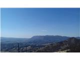
Tošč, which became the highest peak of the Polhov Gradec Hills decades ago when the Yugoslav army lowered Pasja ravan by 9 metres, is located nor...
1 h |
 | Tourist farm Gonte - Tošč
Tošč, which became the highest peak of the Polhov Gradec Hills decades ago when the Yugoslav army lowered Pasja ravan by 9 metres, is located nor...
45 min |
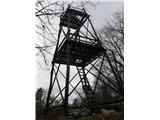
 | Breznica - Lubnik
Lubnik is a 1025 m high mountain that rises steeply west of Škofja Loka. From the summit, where a mountain hut stands, there is a beautiful view ...
40 min |
 | Zapotok - Kurešček
Kurešček is an 826 m high peak located south of Ig and southwest of Želimlje. From the summit, where a church stands, there is no view due to the...
45 min |
 | Javornik - Sveti Jošt above Kranj
Sveti Jošt above Kranj is a hill located west of the slightly lower Šmarjetna gora. From the summit, where the Church of St Jošt stands alongside...
40 min |
 | Pševo - Sveti Jošt above Kranj (Sodar way)
Sveti Jošt above Kranj is a hill located west of the slightly lower Šmarjetna gora. From the summit, where the Church of St Jošt stands alongside...
45 min |
| Čepulje - Sveti Jošt above Kranj
Sveti Jošt above Kranj is a hill located west of the slightly lower Šmarjetna gora. From the summit, where the Church of St Jošt stands alongside...
45 min |
| Pševo - Sveti Jošt above Kranj (Sodarjeva pot, na klopca)
Sveti Jošt above Kranj is a hill located west of the slightly lower Šmarjetna gora. From the summit, where the Church of St Jošt stands alongside...
45 min |
| Pševo - Sveti Jošt above Kranj (Sodarjeva pot, past the chapel)
Sveti Jošt above Kranj is a hill located west of the slightly lower Šmarjetna gora. From the summit, where the Church of St Jošt stands alongside...
50 min |
 | Dom na Govejku - Osolnik
Osolnik is an 858-metre-high mountain located south of Škofja Loka and west of Medvode. From the summit, where the Church of St Mohor and Fortuna...
1 h |
 | Praproče - Polhograjska Gora (Sveti Lovrenc) (gentle path)
Polhograjska Gora, also known simply as Gora or Sveti Lovrenc, is an 824 m high hill northwest of Polhov Gradec. The summit, topped by the Church...
50 min |
 | Ljubljanica - Kožljek
Kožljek is a 788 m high peak located west of Koren, more precisely above the village of Samotorica. From the summit, where there are several benc...
45 min |
 | Planina - Mirna gora
Mirna gora is a 1047 m high, forested peak located on the southeastern edge of Kočevski rog. From the summit, which has a summit register and sta...
45 min |
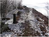
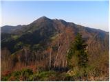
 | Črni Vrh - Pasja ravan
Pasja ravan is the second-highest peak in the Polhograjsko hribovje. A few decades ago, at 1029 meters, it was the highest, but in the second hal...
1 h |
 | Gabrje - Limbarska gora (footpath)
Limbarska gora is located northeast of Moravče. From the summit, there is a beautiful view of the surrounding peaks, and in good weather, the Kam...
45 min |
 | Sv. Andrej - Sveti Ožbolt (above Zminec)
Sveti Ožbolt is situated on a panoramic rise in the north of the Polhograjski Dolomiti. There is a beautiful view toward the Škofjeloško hribovje...
1 h |
 | Račevsko jezero - Vrh Svetih Treh Kraljev
The Church of the Holy Three Kings stands on a panoramic hill above the village of Vrh Svetih Treh Kraljev. The summit features a panorama board ...
45 min |
 | Križevska vas - Cicelj (via farm Buven)
Cicelj is a forest-covered peak located between Moravče and the village of Senožeti. From the summit, which has a bench and a logbook box, there ...
45 min |
 | Križevska vas - Cicelj
Cicelj is a forest-covered peak located between Moravče and the village of Senožeti. From the summit, which has a bench and a logbook box, there ...
40 min |
 | Kuren - Ulovka
Ulovka is a peak between Zaplana and Zavetišče na Planini nad Vrhniko. From the summit, to which ski lifts run, there is a nice view to the north...
50 min |
 | Podgorje - Kojnik (steep path)
Kojnik is a partly forested peak located in the southern part of Podgorski Kras near the Slovenian-Croatian border. From the summit, which has a ...
1 h |
 | Selšček - Velika Špička
Velika Špička or Špičasto Stražišče is a peak located north of Slivnica. From the summit, which has a logbook box with a stamp, there is a nice v...
45 min |
 | GEOSS - Slivna (Pivkelj)
Slivna, also known as Pivkelj (or Pivkelj turn), lies south of Limbarska gora. Pivkelj is the highest point of the Moravška planinska pot and at ...
1 h |
 | Sevski gozd - Sveta Trojica
Sveta Trojica is a distinctly panoramic 1106-meter peak located southwest of the Javorniki. From the summit, where a beautifully restored histori...
45 min |
 | Pivka - Osojnica
Osojnica is a forested hill located west of Pivka. The summit features a logbook box, stamp, and bench, but offers no views....
1 h |
 | Vrbiški dol - Koča na Kozleku
The Koča na Kozleku mountain hut is situated southwest of Ilirska Bistrica, just a few meters below the summit of Kozlek. From the summit, there ...
1 h |
 | Ledine - Sivka
Sivka is a forested peak located west of Žiri and north of Idrija. At the summit there is a stamp for the Slovenian Mountain Trail and a logbook ...
45 min |
 | Rudijev dom na Donački gori - Donačka gora
Donačka gora is a peak located north of Rogatec. From the summit, which geographically belongs to the Karawanks, there is a nice view of the near...
45 min |
 | Komarna vas - Gače
Gače is a popular excursion spot for nature lovers and the only ski center in Dolenjska (SC Bela), offering pleasant skiing in winter and enjoyab...
1 h |
 | Štufna - Veliki Rog
Veliki Rog lies in the middle of the endless forests of the karst plateau Kočevski Rog and, at 1,099 meters above sea level, is its highest peak....
50 min |
 | Mali Log - Koča na Kamnem griču
The Koča na Kamnem griču mountain hut is located on Kamni grič, a panoramic hill rising southwest of Sodražica. From the grassy summit surrounded...
50 min |
 | Lom - Koča na Kamnem griču
The Koča na Kamnem griču mountain hut is located on Kamni grič, a panoramic hill rising southwest of Sodražica. From the grassy summit surrounded...
45 min |
 | Tržič - Kamnek (Radetzky way)
Kamnek (Kamnik on maps, also sometimes Kamnjek) is a panoramic peak above Tržič....
1 h |
 | Tržič (Slap) - Kamnek (via Ride)
Kamnek (Kamnik on maps, also sometimes Kamnjek) is a panoramic peak above Tržič....
55 min |
 | Križna jama - Križna gora
Križna gora is a partly panoramic peak located above the villages of Sveta Ana and Podlož. From the summit, where the Church of the Holy Cross st...
35 min |
 | Leskovec - Obolno
Obolno is a 776-meter-high peak located southwest of the eponymous village. From the grassy summit, by which a radio club hut stands, there is a ...
1 h |
 | Zagrad - Ostrič
Ostrič (marked as Žabnik on some maps) is a 1056 m high peak on the Slovenian side of Čičarija. From the bare summit, where there is a round summ...
1 h 5 min |
 | Velika vrata - Mala Plešivica
Mala Plešivica, which is higher than the neighboring Velika Plešivica, is an exceptionally scenic peak west of the village of Golac, right on the...
35 min |
 | Dule - Kamen vrh
Kamen Vrh is a panoramic hill located on the northern edge of Mala Gora. From the summit, surrounded by low bushes, there are fine views of parts...
45 min |
 | Ortnek - Grmada on Mala gora
Grmada (also Grmada above Ortnek) is an 887-meter-high peak located above the village of Vrh pri Poljanah in the Mala Gora range. Just a few mete...
1 h |
 | Seljan - Stene svete Ane (gentle path)
Stene Svete Ane is a vegetated peak located near the Planinska Koča pri Sveti Ani on Mala Gora. A small observation tower stands on the summit, e...
1 h 5 min |
 | Ortnek - Ortnek Castle
Ortneški Stari Grad is located on the Veliki Žrnovec hill, which rises southwest of the village of Ortnek. Of the castle, built in the 12th centu...
40 min |
 | Col - Kovk
Kovk is a panoramic peak west of Col on an elongated ridge rising steeply above the Vipava Valley. From the summit cross, beautiful views extend ...
1 h |
 | Kampelc - Čelkov vrh
Čelkov vrh is a 1,106-meter peak south of Črni vrh. From the summit, which has a logbook box and stamp, there are fine views toward the Julian Al...
50 min |
 | Zavrate - Govško brdo
Govško brdo is an 811-meter-high hill located west of the village of Huda Jama above Laško. From the summit, which features a logbook box and sta...
40 min |
 | Mislinja - Črepič
Črepič is an 798-meter-high peak west of Mislinja. The summit is forested and offers no view, but there is an expansive panorama from a nearby me...
45 min |
 | Lipa - Smolnik
Smolnik is a 1002-meter-high mountain situated between Menina planina and Dobrovlje. From the summit, where there is a bench, a stamp box and a s...
55 min |
 | Brest - Žbevnica (steep path)
Žbevnica is a 1,014-meter-high peak situated above the village of Brest, on the Slovenian-Croatian border. From the summit, a beautiful view open...
45 min |
 | Brest - Žbevnica (gentle path)
Žbevnica is a 1,014-meter-high peak situated above the village of Brest, on the Slovenian-Croatian border. From the summit, a beautiful view open...
1 h |
 | Petrovo Brdo - Kup
Kup is a 1,046-meter-high peak located between Petrovo Brdo and Podbrdo. From the summit, which features a cross and several transmitters, there ...
45 min |
 | Smrečje - Lavrovec
Lavrovec is an 890-meter-high peak located between Horjul and Žiri. From the summit, which hosts a solar irradiance meter (official measuring poi...
40 min |
 | Suhi Dol - Goli vrh (Official marked path)
Goli vrh (also Golni vrh on maps) is an indistinct, forest-covered peak above the dispersed settlement of Goli Vrh. There is no view from the sum...
1 h |
 | Nemilje - Sveti Primož in Felicijan (Jamnik) (on marked path)
The Church of St. Primož and Felicijan at Jamnik is located on a scenic grassy ridge rising between Kropa and Podblica. From the church or its ne...
50 min |
 | Hunting sports association Vinska Gora - Ramšakov vrh
Ramšakov vrh is the highest point of the circular path around Vinska Gora. At the 970 m high summit, next to the benches, there is also a stamp b...
1 h |
 | Planinski dom pod Ježo - Deveti konfin (survey point 930)
Deveti konfin at survey point 930 is located along the marked path leading from Planinski dom pod Ježo towards Očna. From the meadow a few meters...
55 min |
 | Planinski dom pod Ježo - Deveti konfin (survey point 942)
Deveti konfin at survey point 942 is one of two peaks of Deveti konfin in the Kolovrat range, located between Ježa and Očna. From the summit, whe...
45 min |
 | Kambreško - Globočak
Globočak is an 809 m high peak located in the Kanal Kolovrat range. From the summit, which has some remnants from the First World War, there is n...
50 min |
 | Zavrh pri Trojanah - Reber
Reber is an 878 m high peak located southwest of Trojane. On the summit, which has a logbook box with a logbook and stamp, stands a wooden observ...
45 min |
 | Črne njive - Ahac
Ahac (or Sv. Ahac) is a 799-meter-high peak located east of Ilirska Bistrica. The summit hosts a summit logbox, a cross, and ruins of the former ...
40 min |
 | Cvetrež - Lašček
Lašček, at 1071 m, is the highest peak of the Banjška planota plateau, rising above Čepovanski dol, the Soča valley, and the Idrijca valley. From...
1 h |
 | Bašelj - Gradišče (Pustinjak)
Gradišče or Pustinjak (also Gradišče nad Bašljem) is an 871-meter-high peak located above the Belica stream, which lies below the 2,132-meter-hig...
45 min |
 | Ledinsko Razpotje - Sveta Marija Magdalena (Gore) (east path)
The Church of St. Mary Magdalene is located on a hill above the settlement of Gore, which lies above Idrija. From the church or its immediate sur...
1 h |
 | Poljana (Završnica) - Mali vrh above Završnica
Mali vrh, measuring 863 meters, is one of the peaks on the Brezniške peči ridge (also known as Reber), with the Zavrh valley to the north and the...
35 min |
 | Bele Vode (Sveti Andrej) - Sveti Križ above Bele Vode (upper path)
The Church of St. Cross is located on Kriška gora, formerly called Oslovska gora. Kriška gora rises above Beli Vodi, or above the streams Ljubija...
1 h |
 | Rebrca / Rechberg - Rokov vrh / Rochusberg
Rokov vrh is an 880-meter-high peak (817 m according to some sources), located between the settlements Suha/Zauchen, Rebrca/Rechberg, and Podkraj...
40 min |
| Rebrca / Rechberg - Rokov vrh / Rochusberg (via Bukovnik)
Rokov vrh is an 880-meter-high peak (817 m according to some sources), located between the settlements Suha/Zauchen, Rebrca/Rechberg, and Podkraj...
1 h |
 | Škalske Cirkovce - Skalni vrh (Vodemla)
Skalni vrh is the highest summit of the hill Vodemla, which rises on one side above Paka pri Velenju and on the other above the Velenje Basin. Al...
35 min |
 | Lipovnik - Šteharski vrh (Šteharnikov vrh)
Šteharski vrh (also Šteharnikov vrh or Črneška gora) is a 1,018 m high mountain located in the southeastern part of the Strojna range, between th...
45 min |
 | Podjuna / Jaunstein - Gora svete Eme (Junska gora) / Hemmaberg (detour of closed route)
Gora sv. Eme (Junska gora) / Hemmaberg is located south of the village Podjuna / Jaunstein. On the summit stands the church of St. Ema (Hema) Krš...
55 min |
| Globasnica / Globasnitz - Gora svete Eme (Junska gora) / Hemmaberg
Gora sv. Eme (Junska gora) / Hemmaberg is located south of the village Podjuna / Jaunstein. On the summit stands the church of St. Ema (Hema) Krš...
55 min |
 | Škalske Cirkovce - Lubela (by road)
Lubela is a hill near Velenje that rises to the north above the Šaleška Valley and belongs to the Šentviško Hills or the broader Graška Gora area...
45 min |
 | Onek - Lovski vrh
Lovski vrh is an 830-meter-high peak situated above the settlements of Onek and Mačkovec in the Kočevje Municipality. From the top, which has sev...
45 min |
 | saddle above Lohača - Špilnik (upper path - via Lipovec)
Špilnik is a less visited but very panoramic peak on the southern side of Hrušica, more precisely above the village of Strmec. It holds a central...
40 min |
 | Sveta Katarina (Zgornja Kapla) - Sršenov vrh
Sršenov vrh is a 963-meter-high peak located in the Kozjak hills, more precisely between Ožbalt and Zgornja Kapla. The summit itself offers no sp...
1 h |
 | Ljubnica - Golek (zgornja pot)
Golek is a 769-meter-high peak located northwest of Zreče. The summit has a logbook box with book and stamp, plus a bench; a short distance (a fe...
45 min |
 | Škalske Cirkovce - Stropnik
Stropnik (862 m) and the slightly higher Stropnica (880 m) form a hill rising above Paka pri Velenju on one side and the settlements of Škalske C...
1 h |
 | Škalske Cirkovce - Stropnica
Stropnica (880 m) and slightly lower Stropnik (862 m) form a hill rising above Paka pri Velenju on one side and the settlements Škalske and Šmart...
1 h |
 | Smiljan - Krčmar (Way of the Cross)
Krčmar is a 773-meter-high peak above Smiljan, known for the Nikola Tesla Memorial Center. There is a cross and an HPO stamp on the summit, which...
45 min |
| Smiljan - Krčmar (on marked path)
Krčmar is a 773-meter-high peak above Smiljan, known for the Nikola Tesla Memorial Center. There is a cross and an HPO stamp on the summit, which...
40 min |
 | Omar - Kolevrat
Kolevrat is a lesser-known peak situated above Klenovica. It lies near the path to Kolovratske stijene. From the grassy summit, which has a logbo...
1 h |
 | Sokoli - Sokolske stijene
Sokolske stijene is a lesser-known peak south of the more famous Rudnik, specifically above the hamlet of Sokoli. A monument and summit logbox ar...
45 min |
 | Frbežari - Rudnik (on ski slope)
Rudnik is a peak in the northern part of Gorski Kotar, specifically above the place Tršće, near the Slovenian border. The peak is an HPO point an...
45 min |