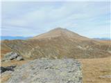
 | Rudno polje - Viševnik
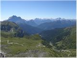
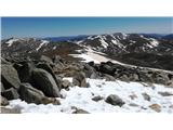
Viševnik is a 2050 m high mountain rising northwest of Rudno polje on Pokljuka. From the summit, where there is a stamp, a beautiful view opens o...
2 h |
 | Rudno polje - Mrežce
Mrežce is a panoramic peak near Lipanski vrh, which is visible on the other side of the gully between the two peaks. Since the slopes towards Pok...
2 h 40 min |
 | Pri Rupah - Lipanski vrh
The panoramic Lipanski vrh is located above the Blejska koča on the Lipanca mountain pasture. From the summit, which drops steeply towards the Kr...
1 h 45 min |
| Rudno polje - Lipanski vrh
The panoramic Lipanski vrh is located above the Blejska koča on the Lipanca mountain pasture. From the summit, which drops steeply towards the Kr...
2 h 55 min |
 | Medvedova konta - Debela peč
Debela peč is a 2014 m high mountain that rises steeply above the Krma valley on one side and gently descends towards the expansive Pokljuka fore...
2 h 15 min |
 | Strmec - Debela peč
Debela peč is a 2014 m high mountain that rises steeply above the Krma valley on one side and gently descends towards the expansive Pokljuka fore...
2 h 30 min |
 | Strmec - Debela peč (old path)
Debela peč is a 2014 m high mountain that rises steeply above the Krma valley on one side and gently descends towards the expansive Pokljuka fore...
2 h 15 min |
 | Planina Loka - Velika Raduha
Velika Raduha, at 2062 m, is the highest peak of the Raduha range, which rises steeply east of Robanov Kot. From the summit, with its registratio...
1 h 55 min |
 | Snežna jama - Velika Raduha
Velika Raduha, at 2062 m, is the highest peak of the Raduha range, which rises steeply east of Robanov Kot. From the summit, with its registratio...
1 h 45 min |
 | Medvedova konta - Brda (west path)
Brda is a panoramic peak situated between Pokljuka and Krma. The summit has a stamp attached to a metal pole and offers a beautiful view towards ...
2 h |
| Medvedova konta - Brda (east path)
Brda is a panoramic peak situated between Pokljuka and Krma. The summit has a stamp attached to a metal pole and offers a beautiful view towards ...
2 h |
 | Rudno polje - Brda (east path)
Brda is a panoramic peak situated between Pokljuka and Krma. The summit has a stamp attached to a metal pole and offers a beautiful view towards ...
3 h 10 min |
 | Rudno polje - Brda (west path)
Brda is a panoramic peak situated between Pokljuka and Krma. The summit has a stamp attached to a metal pole and offers a beautiful view towards ...
2 h 55 min |
| Pri Rupah - Brda (west path)
Brda is a panoramic peak situated between Pokljuka and Krma. The summit has a stamp attached to a metal pole and offers a beautiful view towards ...
2 h |
| Pri Rupah - Brda (east path)
Brda is a panoramic peak situated between Pokljuka and Krma. The summit has a stamp attached to a metal pole and offers a beautiful view towards ...
2 h |
 | Kriška planina - Vrh Korena (via Planina Koren)
Vrh Korena is located between Zvoh and Kalški greben near the Krvavec ski resort. The summit offers a beautiful view of the highest peaks in the ...
2 h 15 min |
| Dom na Gospincu - Vrh Korena (via Dolga njiva)
Vrh Korena is located between Zvoh and Kalški greben near the Krvavec ski resort. The summit offers a beautiful view of the highest peaks in the ...
2 h 25 min |
| Planina Jezerca - Vrh Korena (via planina Koren)
Vrh Korena is located between Zvoh and Kalški greben near the Krvavec ski resort. The summit offers a beautiful view of the highest peaks in the ...
2 h 30 min |
 | Kriška planina - Kompotela
Kompotela is a peak near Mokrica and Vrh Korena. The grass- and dwarf pine-covered summit offers a beautiful view towards Grintovec, Skuta, Brana...
2 h 15 min |
| Planina Jezerca - Kompotela
Kompotela is a peak near Mokrica and Vrh Korena. The grass- and dwarf pine-covered summit offers a beautiful view towards Grintovec, Skuta, Brana...
2 h 30 min |
 | Kriška planina - Mokrica (via Kompotela)
Mokrica is a panoramic peak east of Kompotela. The summit, partially covered with dwarf pines, has a summit logbook....
2 h 45 min |
| Planina Jezerca - Mokrica (via Kompotela)
Mokrica is a panoramic peak east of Kompotela. The summit, partially covered with dwarf pines, has a summit logbook....
3 h |
 | Medvedova konta - Debeli vrh above Lipanca
Debeli vrh is a 1962 m high mountain located in the ridge that rises steeply above the Krma valley. From the summit, where a stamp is attached to...
2 h 15 min |
| Rudno polje - Debeli vrh above Lipanca (via Blejska koča)
Debeli vrh is a 1962 m high mountain located in the ridge that rises steeply above the Krma valley. From the summit, where a stamp is attached to...
2 h 45 min |
 | Planina Ravne - Veliki vrh (Veža) (via Zelene trate)
Veliki Vrh is a 2,110-metre-high mountain located in the central part of the Dleskovec Plateau. From the summit, where there are two registration...
2 h 15 min |
 | Ski hotel Vogel - Vogel (via planina Zadnji Vogel)
Many associate the name Vogel first with the Vogel ski resort near the eponymous peak. From the north, it is recognizable by its pyramidal shape,...
2 h 30 min |
 | Winterleiten parking - Zirbitzkogel
Zirbitzkogel, at 2,396 m, is the highest peak of the Labotniške Alpe / Seetaler Alpen. From the summit, where a cross and a panorama board stand,...
2 h 17 min |
 | Waldheimhütte - Fuchskogel (via Wildsee)
Fuchskogel is a peak south of Zirbitzkogel in the Seetaler Alpen mountain group. The summit is broad and mostly covered in grass. More precisely,...
2 h 45 min |
 | Tonnerhütte - Fuchskogel
Fuchskogel is a peak south of Zirbitzkogel in the Seetaler Alpen mountain group. The summit is broad and mostly covered in grass. More precisely,...
2 h 20 min |
 | Winterleiten parking - Scharfes Eck
Scharfes Eck is a peak on which stands an Austrian meteorological radar station. From the summit, there is a beautiful view of the neighbouring p...
2 h |
 | Walischeben - Weißenstein (Packalpe) (Direct way)
Weißenstein is a grassy mountain crisscrossed with wire fences. From its indistinct summit, there is a nice view of the neighboring Ameringkogel ...
1 h 45 min |
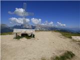
 | Walischeben - Ameringkogel (Packalpe) (Direct way)
Ameringkogel is a grassy summit with a cross and summit register. At 2,187 meters, it is the highest peak of the Packalpe. In good visibility, th...
1 h 55 min |
 | Walischeben - Großenberg (Packalpe) (via Ameringkogel)
Großenberg, also known as Größing, is the northernmost two-thousander in the Packalpe mountain group. From its expansive grassy summit, where a t...
2 h 25 min |
| Walischeben - Großenberg (Packalpe) (below the Ameringkogel summit)
Großenberg, also known as Größing, is the northernmost two-thousander in the Packalpe mountain group. From its expansive grassy summit, where a t...
2 h 20 min |
 | Walischeben - Hofalmkogel (Packalpe) (via Weissenstein)
Hofalmkogel is a less distinct peak in the ridge from Großenberg to Speikkogel. The summit is broad and mostly grassy. From the top, there is a b...
2 h 5 min |
 | Walischeben - Hofalmkogel (Packalpe) (past the cross)
Hofalmkogel is a less distinct peak in the ridge from Großenberg to Speikkogel. The summit is broad and mostly grassy. From the top, there is a b...
2 h 5 min |
| Salzstiegelhaus - Hofalmkogel (Packalpe)
Hofalmkogel is a less distinct peak in the ridge from Großenberg to Speikkogel. The summit is broad and mostly grassy. From the top, there is a b...
1 h 50 min |
 | Walischeben - Speikkogel (Packalpe)
Speikkogel is a spacious and grassy summit in the Packalpe mountain group. From the top, there is a beautiful view towards the Slovenian mountain...
2 h |
 | Jakobe - Petzen (Kordeschkopf) (Peca (Kordeževa glava)) (easy path)
Kordeževa glava, better known as Peca, is the highest peak of the Peca range. It is located on the border with Austria above the Mežiška dolina v...
2 h 15 min |
 | Panoramarestaurant Oben - Petzen (Kordeschkopf) (Peca (Kordeževa glava))
Kordeževa glava, better known as Peca, is the highest peak of the Peca range. It is located on the border with Austria above the Mežiška dolina v...
2 h 5 min |
 | Panoramarestaurant Oben - Petzen (Kordeschkopf) (Peca (Kordeževa glava)) (past old cotage)
Kordeževa glava, better known as Peca, is the highest peak of the Peca range. It is located on the border with Austria above the Mežiška dolina v...
2 h 5 min |
 | Zadnji travnik - Govca (Olševa)
Govca is the highest peak of the Olševa range, rising above Koprivna, Solčava, and Remšenik (Remšenik/Remschenig is a valley on the Austrian side...
1 h 45 min |
 | Plattner - Gartnerkofel (via Watschiger Alm)
Gartnerkofel is a 2,195-meter-high mountain in the Nassfeld ski area. Its Slovenian name is Krniške skale. From the summit, where a cross stands,...
2 h |
 | Planina Ravne - Velika Zelenica (via Zelene trate)
Velika Zelenica is the highest peak of the Dleskovška plateau, offering panoramic views accordingly. The nearby Ojstrica stands out most prominen...
2 h 15 min |
 | Planina Podvežak - Velika Zelenica (via Prag)
Velika Zelenica is the highest peak of the Dleskovška plateau, offering panoramic views accordingly. The nearby Ojstrica stands out most prominen...
2 h 30 min |
 | Rosstratte - Dobratsch / Dobrač (by road)
Dobrač, or in German Dobratsch and also known as Villacher Alpen, is a 2166-meter-high mountain situated on the far eastern edge of the Gailtal A...
2 h |
 | Weinebene - Großer Speikkogel (Koralpe) (panoramic path)
Großer Speikkogel is, at 2,140 meters, the highest peak of Golica/Koralpe, a range east of Volšperk/Wolfsberg. From the summit, where a cross and...
3 h |
| Weinebene - Großer Speikkogel (Koralpe) (via Schäferkreuz)
Großer Speikkogel is, at 2,140 meters, the highest peak of Golica/Koralpe, a range east of Volšperk/Wolfsberg. From the summit, where a cross and...
3 h 15 min |
| Smučišče Koralpe (Koralpenparkplatz) - Großer Speikkogel (Koralpe) (via Großhöllerhütte)
Großer Speikkogel is, at 2,140 meters, the highest peak of Golica/Koralpe, a range east of Volšperk/Wolfsberg. From the summit, where a cross and...
3 h |
 | parking below Weinebene - Großer Speikkogel (Koralpe) (panoramic path)
Großer Speikkogel is, at 2,140 meters, the highest peak of Golica/Koralpe, a range east of Volšperk/Wolfsberg. From the summit, where a cross and...
3 h |
| parking below Weinebene - Großer Speikkogel (Koralpe) (via cross Schäferkreuz)
Großer Speikkogel is, at 2,140 meters, the highest peak of Golica/Koralpe, a range east of Volšperk/Wolfsberg. From the summit, where a cross and...
3 h 15 min |
| parking below Weinebene - Großer Speikkogel (Koralpe) (via Grünangerhütte)
Großer Speikkogel is, at 2,140 meters, the highest peak of Golica/Koralpe, a range east of Volšperk/Wolfsberg. From the summit, where a cross and...
3 h 10 min |
 | Smučišče Koralpe (Koralpenparkplatz) - Großer Speikkogel (Koralpe) (by the edge of the Großes Kar plateau)
Großer Speikkogel is, at 2,140 meters, the highest peak of Golica/Koralpe, a range east of Volšperk/Wolfsberg. From the summit, where a cross and...
2 h 15 min |
 | Ladinger Straße - Speikkogel (Saualpe)
Speikkogel is an indistinct peak in the long ridge of the Svinja mountain pasture / Saualpe. From the spacious summit there is a beautiful view o...
2 h 25 min |
| Ladinger Straße - Speikkogel (Saualpe) (via Offnerhütte)
Speikkogel is an indistinct peak in the long ridge of the Svinja mountain pasture / Saualpe. From the spacious summit there is a beautiful view o...
2 h 35 min |
| Ladinger Straße - Speikkogel (Saualpe) (via Zechhütte)
Speikkogel is an indistinct peak in the long ridge of the Svinja mountain pasture / Saualpe. From the spacious summit there is a beautiful view o...
2 h 20 min |
 | Ladinger Straße - Großer Sauofen (Saualpe)
Großer Sauofen is, due to its location and shorter precipitous southwestern wall, one of the more prominent peaks on the Svinja / Saualpe mountai...
2 h 30 min |
| Ladinger Straße - Großer Sauofen (Saualpe) (via Offnerhütte)
Großer Sauofen is, due to its location and shorter precipitous southwestern wall, one of the more prominent peaks on the Svinja / Saualpe mountai...
2 h 40 min |
| Ladinger Straße - Großer Sauofen (Saualpe) (via Zechhütte)
Großer Sauofen is, due to its location and shorter precipitous southwestern wall, one of the more prominent peaks on the Svinja / Saualpe mountai...
2 h 25 min |
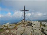
 | Turracher Höhe - Rinsennock (northern way)
Rinsennock is a 2,334 m high peak located in the heart of the Gurktal Alps. From the summit, where a cross stands, there are fine views ranging f...
1 h 45 min |
| Turracher Höhe - Rinsennock (southern way)
Rinsennock is a 2,334 m high peak located in the heart of the Gurktal Alps. From the summit, where a cross stands, there are fine views ranging f...
1 h 45 min |
 | Turracher Höhe - Gruft
Gruft is a grass-covered peak located southeast of the Turracher Höhe pass in the heart of the Gurktal Alps. From its 2,232 m high summit there a...
1 h 45 min |
 | Turracher Höhe - Kaserhöhe
Kaserhöhe is a panoramic peak located in Austrian Carinthia in the heart of the Gurktal Alps. On the spacious summit, which is partly covered in ...
2 h 20 min |
 | Sporthotel Maltatal - Arlhöhe
Arlhöhe is an inconspicuous peak located north of the Kölnbreinspeicher reservoir (above the Maltatal valley). The summit features a panorama boa...
1 h 45 min |
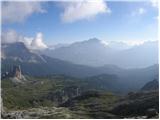 | Passo Falzarego - Rifugio Nuvolau
The mountain hut Rifugio Nuvolau is located on its eponymous summit, southwest of Cortina d'Ampezzo. On clear days, it offers a breathtaking pano...
2 h 15 min |
 | Rifugio Bai de Dones - Rifugio Nuvolau (via Rifugio Cinque Torri)
The mountain hut Rifugio Nuvolau is located on its eponymous summit, southwest of Cortina d'Ampezzo. On clear days, it offers a breathtaking pano...
2 h 35 min |
 | Pri Rupah - Okroglež
Okroglež is a peak covered with dwarf pines, located between Debela peč and Brda. From the summit, which has a stamp (no logbook), a nice view op...
1 h 55 min |
 | Rudno polje - Okroglež
Okroglež is a peak covered with dwarf pines, located between Debela peč and Brda. From the summit, which has a stamp (no logbook), a nice view op...
2 h 55 min |
 | Bukovnik - Lanež
Lanež is a less distinct peak on the eastern part of Raduha. From the spacious summit a nice view opens on nearby Mala Raduha, Olševa, Peca, Uršl...
2 h 20 min |
 | Panoramarestaurant Oben - Feistritzer Spitze
Bistriška špica is a 2113 m high peak located on the Austrian side of Peca. From the summit, which features a cross, there is a fine view of the ...
2 h 5 min |
 | Panoramarestaurant Oben - Feistritzer Spitze (past old cotage)
Bistriška špica is a 2113 m high peak located on the Austrian side of Peca. From the summit, which features a cross, there is a fine view of the ...
2 h |
 | Planina Podvežak - Mala Ojstrica
Mala Ojstrica is an indistinct peak located between Ojstrica, Molička Planina mountain pasture, and Korošica. From the summit, which features a l...
2 h 30 min |
 | Rifugio Rio Gere - Rifugio Tondi
Rifugio Tondi is situated a few meters below the summit of Monte Ciasadio, the highest point of the Faloria ski slope. From the hut, there is a v...
2 h 15 min |
 | Rifugio Valparola - Setsas
The Setsas peak is located west of the Passo Valparola pass and is somewhat distant from the highest summits. Precisely because of this remotenes...
2 h 30 min |
 | Weinebene - Hühnerstütze (Golica/Koralpe)
Hühnerstütze is a 1989 m high peak in the Golica / Koralpe range. From the indistinct, mostly grassy summit, nice views open up on Großer Speikko...
2 h |
 | parking below Weinebene - Hühnerstütze (Golica/Koralpe) (panoramic path)
Hühnerstütze is a 1989 m high peak in the Golica / Koralpe range. From the indistinct, mostly grassy summit, nice views open up on Großer Speikko...
2 h |
 | Gasthof Pfeifferstocker - Handalm
Handalm is a 1853-meter-high peak located north to northeast of the alpine pass Weinebene. From the grassy summit, which features small granite r...
2 h 15 min |
 | Hebalm (Gasthaus Zur Rehbockhütte) - Weberkogel
Weberkogel is a less prominent peak located north to northwest of the alpine pass Weinebene. On the 1805-meter-high summit stands a medium-sized ...
2 h 35 min |
| Gasthof Pfeifferstocker - Weberkogel
Weberkogel is a less prominent peak located north to northwest of the alpine pass Weinebene. On the 1805-meter-high summit stands a medium-sized ...
1 h 50 min |
 | Obertauern - Gamsleitenspitze
Gamsleitenspitze is a 2359-meter-high mountain in the Radstädter Tauern mountain group. From the summit, located above the Obertauern ski center,...
2 h |
 | Zadnji travnik - Obel kamen (Olševa)
Obel kamen is a 1,911-meter-high peak located in the ridge of Olševa. On the summit is a border stone marked RS XXII 1; a cross and summit logboo...
2 h 15 min |
 | Parking Muritzen - Source of Mur / Murusprung (via Sticklerhütte)
The source of the Mur lies at 1,898 m elevation in the Muhrtal (Murwinkel) valley on the eastern foothills of Mureck mountain (2,402 m) in the An...
2 h 15 min |
 | Charlotte Pass - Mount Kosciuszko (Summit Walk)
Mount Kosciuszko is the highest mountain on mainland Australia, the easiest of the elite "Seven Summits", and it is also on the Ultra list. The m...
2 h 45 min |
 | Klippitztörl - Forstalpe (Saualpe) (via Geierkogel)
Forstalpe is an indistinct peak in the massif of Svinška planina / Saualpe. The stamp for Forstalpe is located in an interesting natural window, ...
2 h 10 min |
 | Klippitztörl - Kienberg (Saualpe) (via Geierkogel)
Kienberg is a 2,050-meter-high peak in the massif of Svinška planina / Saualpe. From the grassy summit, a beautiful view opens up over a larger p...
2 h 50 min |
| Klippitztörl - Kienberg (Saualpe)
Kienberg is a 2,050-meter-high peak in the massif of Svinška planina / Saualpe. From the grassy summit, a beautiful view opens up over a larger p...
2 h 20 min |
 | Passo Campolongo - Stores
Stores is a 2,185-meter-high peak on the southeastern part of the Pralongia plateau. From the grassy summit where a cross stands, there is a very...
2 h |
 | Klippitztörl - Gertrusk (Saualpe)
Gertrusk is a panoramic two-thousander in the central part of the Saualpe. A cross stands on the summit, next to it a summit register box with a ...
3 h 5 min |
 | Passo San Pellegrino - Col Margherita
Col Margherita is a 2,514-meter-high mountain rising above the San Pellegrino Pass in the Dolomites. Several cableways lead to it, and in the sum...
3 h |
| Vitlenica - Veliki Vilinac (Vitlenica - Vilinac)
Veliki Vilinac is one of the peaks of the Čvrsnica mountain range, located west of Jablanica in Blidinje Nature Park. Čvrsnica is bounded by the ...
3 h |
 | parking below Weinebene - Krakaberg (Golica / Koralpe) (panoramic path)
Krakaberg is a 2,070-meter-high peak located south of Großer Speikkogel, the highest peak of Golica / Koralpe. From the summit, a nice view opens...
3 h 10 min |
 | Knödelhütte - Hirschegger Alm (northern peak)
Hirschegger Alm (northern peak) is a 1,871-meter-high peak in the Packalpe mountain group. From the grassy summit, a beautiful view opens up all ...
2 h 25 min |
| Unterauerlinger Hütte - Hirschegger Alm (northern peak)
Hirschegger Alm (northern peak) is a 1,871-meter-high peak in the Packalpe mountain group. From the grassy summit, a beautiful view opens up all ...
2 h 15 min |
 | Salzstiegelhaus - Peterer Riegel
Peterer Riegel is a panoramic peak above the Peterer Sattel saddle. From the summit, where a cross stands and a bench sits below it, a beautiful ...
1 h 45 min |
 | Weinebene - Steinschneider (via Großes Kar)
Steinschneider is a 2070-meter-high peak in the Golica / Koralpe mountain range, situated northwest of Großer Speikkogel, the highest peak of the...
3 h 15 min |
| parking below Weinebene - Steinschneider (via Großes Kar)
Steinschneider is a 2070-meter-high peak in the Golica / Koralpe mountain range, situated northwest of Großer Speikkogel, the highest peak of the...
3 h 15 min |
| Smučišče Koralpe (Koralpenparkplatz) - Steinschneider (by the edge of the Großes Kar plateau)
Steinschneider is a 2070-meter-high peak in the Golica / Koralpe mountain range, situated northwest of Großer Speikkogel, the highest peak of the...
1 h 50 min |
 | Nassfeld - Garnitzenberg / Monte Carnizza (via Auernig Alm)
Krniška gora (Italian Monte Carnizza, German Garnitzenberg) is a 1950-meter-high mountain east of the Mokrine mountain pass. It is located on the...
1 h 50 min |
| Nassfeld - Garnitzenberg / Monte Carnizza (Auernig Höhenweg)
Krniška gora (Italian Monte Carnizza, German Garnitzenberg) is a 1950-meter-high mountain east of the Mokrine mountain pass. It is located on the...
2 h |
 | Kohlebnerstand - Windberg (northern path)
Windberg is a 1903-meter-high peak in the Schneealpe mountain group and, with its elevation, the highest peak of the group. From the summit, wher...
1 h 50 min |
| Kohlebnerstand - Windberg (southern path)
Windberg is a 1903-meter-high peak in the Schneealpe mountain group and, with its elevation, the highest peak of the group. From the summit, wher...
1 h 50 min |
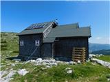 | Raxalm-Berggasthof (Rax) - Raxgmoahütte (Rax)
Raxgmoahütte is a hut owned by the Austrian mountain rescue service, open year-round as a bivouac or shelter. From the hut on top of a panoramic ...
2 h 15 min |
 | Ladinger Straße - Sandkogel (via Offnerhütte)
Sandkogel is an indistinct panoramic peak rising to 2011 meters in the Svinja range....
2 h 20 min |
| Ladinger Straße - Sandkogel (via Zechhütte)
Sandkogel is an indistinct panoramic peak rising to 2011 meters in the Svinja range....
2 h 15 min |