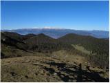
 | Tomčeva koča na Poljški planini - Begunjščica
Begunjščica is a mountain range in the Karawanks east of Stol. Its highest peak is Veliki Vrh, which at over 2,000 m offers a fine view across ce...
2 h 50 min |
 | Šport hotel - Mrežce
Mrežce is a panoramic peak near Lipanski vrh, which is visible on the other side of the gully between the two peaks. Since the slopes towards Pok...
2 h 40 min |
 | Rudno polje - Mrežce
Mrežce is a panoramic peak near Lipanski vrh, which is visible on the other side of the gully between the two peaks. Since the slopes towards Pok...
2 h 40 min |
 | Rudno polje - Lipanski vrh
The panoramic Lipanski vrh is located above the Blejska koča on the Lipanca mountain pasture. From the summit, which drops steeply towards the Kr...
2 h 55 min |
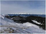
 | Šport hotel - Debela peč
Debela peč is a 2014 m high mountain that rises steeply above the Krma valley on one side and gently descends towards the expansive Pokljuka fore...
3 h 30 min |
 | Rudno polje - Debela peč
Debela peč is a 2014 m high mountain that rises steeply above the Krma valley on one side and gently descends towards the expansive Pokljuka fore...
3 h 15 min |
 | Vrh Bače - Črna prst
On the northern slope of the summit ridge of Črna prst, black soil is visible the feature after which the mountain is named. Črna prst is renown...
3 h 10 min |
 | Gozd - Tolsti vrh (steep path over Kriška gora)
Tolsti vrh, located west of Storžič, is at 1715 metres also the highest peak of the Kriška gora range, which rises steeply above central Gorenjsk...
2 h 45 min |
 | Mašun - Veliki Snežnik
Veliki Snežnik, at 1796 meters, is the highest peak in the nearby and distant surroundings, offering beautiful views over much of Slovenia and ne...
4 h |
 | Bukovnik - Velika Raduha (via Durce)
Velika Raduha, at 2062 m, is the highest peak of the Raduha range, which rises steeply east of Robanov Kot. From the summit, with its registratio...
2 h 50 min |
 | Radušnik - Velika Raduha
Velika Raduha, at 2062 m, is the highest peak of the Raduha range, which rises steeply east of Robanov Kot. From the summit, with its registratio...
3 h 10 min |
| Planina Kosmačeve Rastke - Velika Raduha
Velika Raduha, at 2062 m, is the highest peak of the Raduha range, which rises steeply east of Robanov Kot. From the summit, with its registratio...
2 h 55 min |
 | Planina Vodol - Velika Raduha
Velika Raduha, at 2062 m, is the highest peak of the Raduha range, which rises steeply east of Robanov Kot. From the summit, with its registratio...
2 h 40 min |
 | Planina Blato - Mala Tičarica (via Štapce)
Mala Tičarica is a highly panoramic mountain above the Twin Triglav Lakes. From the summit there is a beautiful view toward the Koča pri Triglavs...
3 h 25 min |
 | End of road on Vogar - Mala Tičarica (via Štapce)
Mala Tičarica is a highly panoramic mountain above the Twin Triglav Lakes. From the summit there is a beautiful view toward the Koča pri Triglavs...
3 h 30 min |
 | Tuškov Grič - Blegoš (via Črni vrh)
Blegoš is a 1,562-metre-high mountain located between the Selška Sora and Poljanska Sora rivers. From the grassy summit, where there is a stamp a...
2 h 45 min |
 | Rute (Zavrh) / Bärental - Barentaler Kotschna/Struška (via Bärensattel)
Struška is a smaller mountain range in the Karavanke ridge, located between Stol (specifically Belščica) and Golica. From Veliki vrh (1944 m), th...
2 h 45 min |
 | Tuškov Grič - Porezen (by road)
Porezen is a 1,630 m high mountain situated between Davča and Baška Grapa. From the summit, where a large Partisan monument stands, a beautiful v...
3 h 5 min |
 | Raspet - Porezen (on ridge of Cimprovka)
Porezen is a 1,630 m high mountain situated between Davča and Baška Grapa. From the summit, where a large Partisan monument stands, a beautiful v...
2 h 45 min |
 | Preval Vrh Ravni - Porezen (via Dom na Poreznu)
Porezen is a 1,630 m high mountain situated between Davča and Baška Grapa. From the summit, where a large Partisan monument stands, a beautiful v...
2 h 35 min |
 | Planina pod Golico (Betel) - Kahlkogel/Golica (via Suha saddle)
Golica is an unvegetated peak located north of Jesenice. From the summit, where a registration box is placed, there is a fine view of the western...
2 h 50 min |
 | Dom Pristava in Javorniški Rovt - Kahlkogel/Golica (mimo Koče na Golici)
Golica is an unvegetated peak located north of Jesenice. From the summit, where a registration box is placed, there is a fine view of the western...
2 h 55 min |
 | Šport hotel - Brda (east path)
Brda is a panoramic peak situated between Pokljuka and Krma. The summit has a stamp attached to a metal pole and offers a beautiful view towards ...
3 h 15 min |
 | Rudno polje - Brda (east path)
Brda is a panoramic peak situated between Pokljuka and Krma. The summit has a stamp attached to a metal pole and offers a beautiful view towards ...
3 h 10 min |
 | Rudno polje - Brda (west path)
Brda is a panoramic peak situated between Pokljuka and Krma. The summit has a stamp attached to a metal pole and offers a beautiful view towards ...
2 h 55 min |
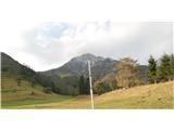
 | Laško (obračališče nad vasjo) - Bašeljski vrh
Bašeljski vrh is a 1744-meter-high mountain located between Mali Grintovec and Storžič. From the summit, where there is a bench and a registratio...
2 h 35 min |
 | MHE Zabukovec - Bašeljski vrh
Bašeljski vrh is a 1744-meter-high mountain located between Mali Grintovec and Storžič. From the summit, where there is a bench and a registratio...
3 h 10 min |
 | Erjavčev rovt - Frauenkogel/Dovška Baba (via Brvog)
Dovška Baba is a 1891-meter-high peak located on the border ridge between Slovenia and Austria. From the summit, which has a registration box and...
2 h 45 min |
 | Ljubelj - Srednji vrh (above Završnica) (via source of Završnica)
Srednji vrh is a panoramic mountain covered in dwarf pine, located between Stol, Vrtača and Begunjščica. From the summit, which drops steeply to ...
2 h 40 min |
 | Ljubelj - Srednji vrh (above Završnica) (on the slope of Vrtača)
Srednji vrh is a panoramic mountain covered in dwarf pine, located between Stol, Vrtača and Begunjščica. From the summit, which drops steeply to ...
3 h |
 | Ljubelj - Srednji vrh (above Završnica) (on a slope of Vrtača)
Srednji vrh is a panoramic mountain covered in dwarf pine, located between Stol, Vrtača and Begunjščica. From the summit, which drops steeply to ...
2 h 40 min |
 | Javorje - Rodica (marked way)
The mountain Rodica is located above Bohinj in the Lower Bohinj Mountains. From the summit there is a beautiful view over the Julian Alps and the...
2 h 45 min |
 | Rudno polje - Debeli vrh above Lipanca (via Kačji rob)
Debeli vrh is a 1962 m high mountain located in the ridge that rises steeply above the Krma valley. From the summit, where a stamp is attached to...
2 h 45 min |
 | Šport hotel - Debeli vrh above Lipanca
Debeli vrh is a 1962 m high mountain located in the ridge that rises steeply above the Krma valley. From the summit, where a stamp is attached to...
3 h 15 min |
| Rudno polje - Debeli vrh above Lipanca (via Blejska koča)
Debeli vrh is a 1962 m high mountain located in the ridge that rises steeply above the Krma valley. From the summit, where a stamp is attached to...
2 h 45 min |
 | Črnivec - Lepenatka
Lepenatka is a grassy peak located south of the 1557-metre-high Rogatec. From the summit, which has a summit register box and stamp, there is a b...
3 h 15 min |
 | Jekarica - Mali Grintovec
Mali Grintovec is a panoramic mountain located east of Storžič. From the summit, which has a summit register box, stamp, and a pleasant bench, th...
2 h 55 min |
| Laško (obračališče nad vasjo) - Mali Grintovec (via Dom na Kališču)
Mali Grintovec is a panoramic mountain located east of Storžič. From the summit, which has a summit register box, stamp, and a pleasant bench, th...
3 h 10 min |
 | Velacher Kotschna/Belska Kočna - Goli vrh
Goli vrh is a 1787 m high mountain situated between the Ravenska Kočna and Belska Kočna valleys. From the bare summit, which has a registration b...
2 h 45 min |
 | Baumgartnerhof - Kresišče
Kresišče is an 1839 m high peak in the main ridge of the Karawanks, specifically between Kepa and Trupejevo poldne. From the summit, where a wood...
3 h |
 | Koča pri izviru Soče - Vršič vrh
Vršič is a 1,737-metre-high mountain situated between the Poštarski dom hut and the Vršič pass. From the summit, where there is a registration bo...
2 h 40 min |
 | Preval - Koprivnik
Koprivnik is a 1393-meter-high mountain located between Blegoš and Mladi vrh. From the summit, which has a registration box and a stamp, the view...
3 h 15 min |
 | Črnivec - Vivodnik
Vivodnik, at 1508 meters, is the highest peak of Menina planina, a plateau rising south of Gornji Grad. From the summit, which has a small observ...
4 h 30 min |
 | Koča pri izviru Soče - Sovna glava
Sovna Glava is a 1750-meter-high grassy peak situated between Prisank and the Vršič Pass. From the summit, there is a nice view of the peaks risi...
2 h 40 min |
 | Baumgartnerhof - Mallestiger Mittagskogel
Ostra peč, known in German as Mallestiger Mittagskogel, is an 1801 m high mountain located on the northern side of the main Karawanks ridge. From...
3 h 15 min |
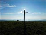
 | Valvasorjev dom pod Stolom - Potoški Stol
Potoški Stol is located between Stol and Vajnež on the border with Austria. A cross stands just a few metres below the grassy summit. The finest ...
3 h 5 min |
 | Andrejev dom na Slemenu - Smrekovec
Smrekovec is a mountain of volcanic origin on the eastern edge of the Smrekovec mountain range. The wide grassy summit features a pyramid with a ...
3 h 30 min |
 | Valley of stream Žep - Veliki Travnik (Turnovka)
Veliki Travnik, also known as Turnovka by the locals, is located on the western edge of the Smrekovec mountain range. From the summit, which has ...
2 h 45 min |
 | Bistra - Veliki Travnik (Turnovka)
Veliki Travnik, also known as Turnovka by the locals, is located on the western edge of the Smrekovec mountain range. From the summit, which has ...
3 h 45 min |
 | Gorenje pri Zrečah - Rogla
Rogla is a peak in the middle of the eponymous ski resort. The peak is forested with a small clearing on which stands a lookout tower. The tower ...
2 h 35 min |
 | Mašun - Mali Snežnik
Mali Snežnik is a peak on the western ridge of Snežnik. Covered with dwarf pines, the summit offers beautiful views of the neighboring Veliki Sne...
3 h 35 min |
 | Trate / Johannsenruhe - Ovčji vrh (Kozjak) / Geissberg (Kosiak) (southeast path)
Ovčji Vrh or Kozjak, known in German as Geissberg or Kosiak, is a 2024 m high peak located north of the main Karawanks ridge. Rising above Celovš...
2 h 35 min |
 | Planina Kuk - Vogel (direct way)
Many associate the name Vogel first with the Vogel ski resort near the eponymous peak. From the north, it is recognizable by its pyramidal shape,...
2 h 45 min |
| Planina Kuk - Vogel (via Globoko)
Many associate the name Vogel first with the Vogel ski resort near the eponymous peak. From the north, it is recognizable by its pyramidal shape,...
3 h 30 min |
 | Tolminske Ravne - Vogel (on mule track)
Many associate the name Vogel first with the Vogel ski resort near the eponymous peak. From the north, it is recognizable by its pyramidal shape,...
3 h 30 min |
 | Poštarski dom pod Plešivcem - Uršlja gora (Plešivec) (via Kal)
Uršlja gora, or Plešivec, is a panoramic mountain between Slovenj Gradec and Črna na Koroškem. At or just below the summit stands the Church of S...
2 h 45 min |
 | Andrejev dom na Slemenu - Uršlja gora (Plešivec)
Uršlja gora, or Plešivec, is a panoramic mountain between Slovenj Gradec and Črna na Koroškem. At or just below the summit stands the Church of S...
2 h 45 min |
 | Sveti Danijel (Zgornji Razbor) - Uršlja gora (Plešivec)
Uršlja gora, or Plešivec, is a panoramic mountain between Slovenj Gradec and Črna na Koroškem. At or just below the summit stands the Church of S...
3 h 15 min |
 | Drežniške Ravne - Krasji vrh (via snežna jama)
Krasji vrh is situated between Bovec and Kobarid on the Polovnik mountain ridge. At 1773 m it is also the highest peak of the mentioned ridge, so...
3 h |
 | Koutschitz Alm/Kočiška planina - Poludnig/Poludnik
Poludnik/Poludnig is located on the eastern part of the Carnic Alps. Because there is no higher peak nearby, there is a very nice view from Polud...
3 h |
 | Zajzera - Svete Višarje / Monte Lussari (by road)
Svete Višarje / Monte Lussari is a pilgrimage site for Slavs, Germans, and Romance peoples. Already in the 16th century, the mountain was called ...
3 h |
 | Spodnje Sleme - Govca (Olševa)
Govca is the highest peak of the Olševa range, rising above Koprivna, Solčava, and Remšenik (Remšenik/Remschenig is a valley on the Austrian side...
3 h |
 | Pod Peco / Koprein-Petzen - Govca (Olševa) (via Kumer)
Govca is the highest peak of the Olševa range, rising above Koprivna, Solčava, and Remšenik (Remšenik/Remschenig is a valley on the Austrian side...
4 h 30 min |
| Mountain hut on farm Kumer - Govca (Olševa)
Govca is the highest peak of the Olševa range, rising above Koprivna, Solčava, and Remšenik (Remšenik/Remschenig is a valley on the Austrian side...
3 h 45 min |
 | Jasna - Ciprnik (via Mojčin dom)
A hidden yet scenic peak above the Kranjska Gora ski slopes. To the east are the Martuljek Mountains; on the other side, Jalovec, Ponce, and Mojs...
3 h |
| Kranjska Gora - Ciprnik (via Bedančev dom)
A hidden yet scenic peak above the Kranjska Gora ski slopes. To the east are the Martuljek Mountains; on the other side, Jalovec, Ponce, and Mojs...
2 h 55 min |
 | Bohinjsko sedlo - Krevl
Krevl is a 1515-meter-high peak situated south of the Kobla ski area, more precisely between the Kobla peak and Kravja Črna gora. From the summit...
2 h 50 min |
 | Platak - Veliki Risnjak
Veliki Risnjak, at 1528 m, is the highest peak of Risnjak National Park. From the summit, which has a logbook box and stamp, there is a very nice...
3 h 30 min |
 | Windische Hohe - Kobesnock
Kobesnock is a lesser-known peak west of the massive Dobrač range. From its summit, which features a cross, there are fine views of Dobrač, the l...
2 h 45 min |
 | Ladinger Straße - Speikkogel (Saualpe) (via Offnerhütte)
Speikkogel is an indistinct peak in the long ridge of the Svinja mountain pasture / Saualpe. From the spacious summit there is a beautiful view o...
2 h 35 min |
 | Ladinger Straße - Großer Sauofen (Saualpe) (via Offnerhütte)
Großer Sauofen is, due to its location and shorter precipitous southwestern wall, one of the more prominent peaks on the Svinja / Saualpe mountai...
2 h 40 min |
 | Ladinger Straße - Ladinger Spitz (Saualpe) (via Ladinger Hütte)
Velika Svinja, known in German as Ladinger Spitz, is at 2079 m the highest peak of the Svinja / Saualpe mountain range. From the summit, which ha...
3 h |
 | Ladinger Straße - Ladinger Spitz (Saualpe) (via Wolfsberger Hütte)
Velika Svinja, known in German as Ladinger Spitz, is at 2079 m the highest peak of the Svinja / Saualpe mountain range. From the summit, which ha...
2 h 50 min |
 | Libinjska kosa - Sveto brdo
Sveto brdo (1,752 m) is the second-highest peak of Velebit. Located in the southeastern part of the range, it offers beautiful views of Velebit i...
3 h 20 min |
 | Rudno polje - Okroglež
Okroglež is a peak covered with dwarf pines, located between Debela peč and Brda. From the summit, which has a stamp (no logbook), a nice view op...
2 h 55 min |
 | Koprivna (Kumer) - Wackendorfer Spitze
Veška kopa, also known as Veški vrh or by its German name Wackendorfer Spitze, is the northernmost two-thousander in the Peca range. From its ind...
2 h 55 min |
 | Cave del Predil - Šober / Monte Sciober Grande
Šober / Monte Sciober Grande is a 1,845 m high peak located between the Remšendol Valley and Jezerska Valley. From the summit there is a fine vie...
2 h 45 min |
 | Bohinjsko sedlo - Gladki vrh (Ratitovec)
Gladki vrh (Ratitovec), at 1,667 meters, is the most visited peak in the Ratitovec range. From its bare summit, which features a panorama board, ...
3 h 35 min |
 | Forestry cottage Rovtarica - Gladki vrh (Ratitovec)
Gladki vrh (Ratitovec), at 1,667 meters, is the most visited peak in the Ratitovec range. From its bare summit, which features a panorama board, ...
3 h 35 min |
 | Razglednik - Gladki vrh (Ratitovec)
Gladki vrh (Ratitovec), at 1,667 meters, is the most visited peak in the Ratitovec range. From its bare summit, which features a panorama board, ...
3 h 5 min |
 | Bohinjsko sedlo - Altemaver (Ratitovec)
Altemaver (Ratitovec), at 1,678 meters, is the highest peak of Ratitovec. From its grassy summit, there is a beautiful view of the Julian Alps, J...
3 h 15 min |
 | Forestry cottage Rovtarica - Altemaver (Ratitovec)
Altemaver (Ratitovec), at 1,678 meters, is the highest peak of Ratitovec. From its grassy summit, there is a beautiful view of the Julian Alps, J...
3 h 40 min |
| Razglednik - Altemaver (Ratitovec)
Altemaver (Ratitovec), at 1,678 meters, is the highest peak of Ratitovec. From its grassy summit, there is a beautiful view of the Julian Alps, J...
3 h 10 min |
| Soriška peč - Altemaver (Ratitovec)
Altemaver (Ratitovec), at 1,678 meters, is the highest peak of Ratitovec. From its grassy summit, there is a beautiful view of the Julian Alps, J...
3 h |
 | Montemaggiore - Punta di Montemaggiore
Breški Jalovec, or Punta di Montemaggiore in Italian, is a 1613-meter-high mountain located above the source of the Nadiža River, specifically on...
3 h |
 | Baumgartnerhof - Maloško poldne / Mallestiger Mittagskogel
Maloško poldne, or Mallestiger Mittagskogel in German, is a 1,823-meter-high peak on the border between Slovenia and Austria, precisely between T...
2 h 45 min |
 | Bad Kleinkirchheim - Kaiseburg
Kaiseburg is a panoramic peak located directly above the Bad Kleinkirchheim ski area. From the summit, where a cross stands, a beautiful view ope...
3 h 25 min |
 | Bad Kleinkirchheim - Kaiseburg (by road)
Kaiseburg is a panoramic peak located directly above the Bad Kleinkirchheim ski area. From the summit, where a cross stands, a beautiful view ope...
3 h 55 min |
 | Tolminske Ravne - Tolminski Migovec
Tolminski Migovec is a 1881 m high mountain. Its western slope above the Tolminka valley is the steepest and most scenic. The southern slope is i...
2 h 45 min |
 | Poden / Bodental - Kosmatica / Kosmatitza
Kosmatica / Kosmatitza is a 1,659-meter-high peak entirely on the Austrian side of the Karawanks, north of Vrtača. From the summit, which is part...
2 h 40 min |
 | Planina Zajzera - Krniška glavica / Jof di Sompdogna (path 639 and 652)
Krniška glavica (Jof di Sompdogna) is a 1,889-meter-high peak in the Western Julian Alps, north of Montaž. A cross stands on the panoramic summit...
3 h 10 min |
 | Pass Lius above Ligosullo - Tersadia (from Ligosullo)
Tersadia is a mountain in the heart of the Carnic Alps, just far enough from its higher neighbors to serve as an excellent vantage point, especia...
3 h |
 | Mariensee - Niederwechsel (red trail)
Niederwechsel is a panoramic peak in the Wechsel massif. From the summit, fine views extend far in all directions, since there are no higher peak...
3 h 15 min |
 | Rettenegg - Grazer Stuhleck (past Roseggerhaus)
Grazer Stuhleck is a 1,635-meter-high peak located southwest of Stuhleck, the highest summit of the Fischbacher Alpen mountain group. Numerous wi...
2 h 40 min |
| Rettenegg - Grazer Stuhleck (via Schwarzriegel)
Grazer Stuhleck is a 1,635-meter-high peak located southwest of Stuhleck, the highest summit of the Fischbacher Alpen mountain group. Numerous wi...
2 h 40 min |
 | Rettenegg - Geiereck (via Schwarzriegel)
Geiereck is a panoramic peak located northeast of the Roseggerhaus hut and southeast of the Geiereckalm alpine pasture....
2 h 55 min |
 | Rettenegg - Peter-Bergner-Warte (Pretul) (via Schwarzriegel)
The Peter-Bergner-Warte viewpoint is located on the 1,656-meter-high Pretul summit above the settlement of Rettenegg....
3 h 5 min |
 | Rettenegg - Amundsenhöhe (via Schwarzriegel)
Amundsenhöhe is a 1,666-meter-high panoramic peak in the Fischbacher Alpen mountain group. From the summit there is a nice view of the hill count...
3 h 20 min |
 | Hirschegg - Hirschegger Alm (southern peak) (via Saureishütte)
The southern peak in the Hirschegger Alm ridge is located west of the settlement of Hirschegg. From the summit, where a cross stands, a beautiful...
3 h 5 min |
 | Hirschegg - Hirschegger Alm (southern peak) (via Bernsteinhütte)
The southern peak in the Hirschegger Alm ridge is located west of the settlement of Hirschegg. From the summit, where a cross stands, a beautiful...
3 h |
 | Hirschegg - Hirschegger Alm (northern peak) (via Seinerkreuz)
Hirschegger Alm (northern peak) is a 1,871-meter-high peak in the Packalpe mountain group. From the grassy summit, a beautiful view opens up all ...
3 h |
| Hirschegg - Hirschegger Alm (northern peak) (via Bernsteinhütte)
Hirschegger Alm (northern peak) is a 1,871-meter-high peak in the Packalpe mountain group. From the grassy summit, a beautiful view opens up all ...
3 h 50 min |
 | Hirschegg - Seinerkreuz
Seinerkreuz is a panoramic peak located above the Saureishütte hut and the settlement of Hirschegg. From the summit, a beautiful view opens up of...
2 h 35 min |
 | Zelovo - Svilaja (past Umac)
Svilaja is a 1509-meter grassy peak above Peručko Lake, north of the town of Sinj. The summit features a cross and a concrete pillar. From the to...
3 h |
 | Seetal - Voisthalerhütte
The Voisthalerhütte mountain hut is situated on a scenic rise at the beginning of the Obere Dullwitz valley. From the hut, beautiful views open u...
2 h 50 min |
 | Unternberg - Arabichl (via Kampstein)
Arabichl is a panoramic peak situated above the eponymous ski lift. From the summit, a splendid view opens up of the Wechsel group, Stuhleck, and...
3 h 45 min |
| St. Corona am Wechsel - Arabichl
Arabichl is a panoramic peak situated above the eponymous ski lift. From the summit, a splendid view opens up of the Wechsel group, Stuhleck, and...
3 h 15 min |
 | Gasen - Plankogel (by learning trail)
Plankogel is a 1531-meter-high mountain situated in the Almenland nature park. From the panoramic summit, where a cross stands, a beautiful view ...
2 h 35 min |
 | Oberfresen (Brendlwald) - Bürgerhalt (Koralpe)
Bürgerhalt is a lesser-known peak in the Golica / Koralpe mountain range, situated between the peaks Krennkogel and Großer Frauenkogel....
3 h 15 min |
 | Alpl (Zisleranger Weg) - Steinriegel
Steinriegel is a panoramic peak with a cross and a wind power plant, located in the hills east of the Mur....
2 h 40 min |
| Alpl (Waldschulle Alpl) - Steinriegel
Steinriegel is a panoramic peak with a cross and a wind power plant, located in the hills east of the Mur....
3 h 10 min |
 | Aflenz Kurort (Bürgergraben) - Hochstein (at Mitteralm)
Hochstein is a scenic summit with a cross and summit register box in the Hochschwab mountain group, between Windgrube peak and the Mitteralm plat...
3 h 20 min |
 | Ferienheim - Leobner Mauer
Leobner Mauer is a 1,870-meter peak located west to southwest of the higher and better-known Hochturm peak. From the summit, there is a fine view...
3 h 10 min |
 | Odcep s ceste na Jelovo Rujo - Visočica
Visočica is a prominent mountain visible from afar, located above Lika in the Southern Velebit. Its southern and western slopes are grassy, where...
3 h |