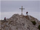
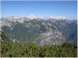
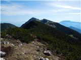
 | Urbas - Hochstuhl/Stol
Stol is, at 2,236 m, the highest peak in the Karawanks. From the summit, which has a registration box and stamp, a beautiful view opens onto the ...
3 h 15 min |
 | Razpotje Vragovec - Hochstuhl/Stol (via Doslovška planina and hunting cottage)
Stol is, at 2,236 m, the highest peak in the Karawanks. From the summit, which has a registration box and stamp, a beautiful view opens onto the ...
3 h 10 min |
 | Planina Jezerca - Veliki Zvoh (on unmarked path via Razor)
Veliki Zvoh is the highest point of the Krvavec ski resort. The cable car does not quite reach the summit but stops only a few metres short. A fe...
2 h 15 min |
| Markova raven - Veliki Zvoh (on unmarked path via Razor)
Veliki Zvoh is the highest point of the Krvavec ski resort. The cable car does not quite reach the summit but stops only a few metres short. A fe...
3 h |
 | Zavetišče na planini Šija - Veliki vrh (Košuta) (Kačja pot)
Veliki Vrh, at 2,088 m, is the westernmost two-thousander in Slovenia's longest ridge, the Košuta. From the summit, which has a registration box ...
2 h |
 | Rudno polje - Mrežce (via Zgornji Razor)
Mrežce is a panoramic peak near Lipanski vrh, which is visible on the other side of the gully between the two peaks. Since the slopes towards Pok...
2 h |
 | end of road on Pokljuka - Tosc
Tosc is located in the heart of the Julian Alps between Veliki Draški vrh and Mišelj vrh. From the grassy summit there is a very fine view of Tri...
3 h 25 min |
 | Gozd - Tolsti vrh (Sheep Trail across Kriška Gora)
Tolsti vrh, located west of Storžič, is at 1715 metres also the highest peak of the Kriška gora range, which rises steeply above central Gorenjsk...
2 h 30 min |
 | Tržiški graben - Veliki Javornik (Ženiklovec)
Veliki Javornik (also known as Ženiklovec) is a 1716 m high peak located between Storžič and Stegovnik. From the grassy summit with its registrat...
2 h 30 min |
 | Križovec - Barentaler Kotschna/Struška (čez Sedlo Kočna)
Struška is a smaller mountain range in the Karavanke ridge, located between Stol (specifically Belščica) and Golica. From Veliki vrh (1944 m), th...
2 h 30 min |
| Križovec - Barentaler Kotschna/Struška (by road)
Struška is a smaller mountain range in the Karavanke ridge, located between Stol (specifically Belščica) and Golica. From Veliki vrh (1944 m), th...
2 h 15 min |
 | Planina pod Golico (Betel) - Barentaler Kotschna/Struška
Struška is a smaller mountain range in the Karavanke ridge, located between Stol (specifically Belščica) and Golica. From Veliki vrh (1944 m), th...
3 h |
 | Dom Pristava in Javorniški Rovt - Barentaler Kotschna/Struška (via Dobravske rovte)
Struška is a smaller mountain range in the Karavanke ridge, located between Stol (specifically Belščica) and Golica. From Veliki vrh (1944 m), th...
2 h 30 min |
| Dom Pristava in Javorniški Rovt - Barentaler Kotschna/Struška (čez Sedlo Kočna)
Struška is a smaller mountain range in the Karavanke ridge, located between Stol (specifically Belščica) and Golica. From Veliki vrh (1944 m), th...
3 h 15 min |
| Dom Pristava in Javorniški Rovt - Barentaler Kotschna/Struška (by road)
Struška is a smaller mountain range in the Karavanke ridge, located between Stol (specifically Belščica) and Golica. From Veliki vrh (1944 m), th...
3 h |
 | Planina pod Golico - Kahlkogel/Golica (via Ovčarska koča - eastern way)
Golica is an unvegetated peak located north of Jesenice. From the summit, where a registration box is placed, there is a fine view of the western...
2 h 50 min |
 | Križovec - Kahlkogel/Golica (on ridge)
Golica is an unvegetated peak located north of Jesenice. From the summit, where a registration box is placed, there is a fine view of the western...
2 h 5 min |
| Dom Pristava in Javorniški Rovt - Kahlkogel/Golica (on the ridge)
Golica is an unvegetated peak located north of Jesenice. From the summit, where a registration box is placed, there is a fine view of the western...
2 h 50 min |
 | Erjavčev rovt - Frauenkogel/Dovška Baba (direct way)
Dovška Baba is a 1891-meter-high peak located on the border ridge between Slovenia and Austria. From the summit, which has a registration box and...
2 h 15 min |
 | Rogarjev rovt - Frauenkogel/Dovška Baba (via Rožca and Hruški vrh)
Dovška Baba is a 1891-meter-high peak located on the border ridge between Slovenia and Austria. From the summit, which has a registration box and...
2 h 30 min |
 | Tinčkova koča - Srednji vrh (above Završnica) (via Zagon)
Srednji vrh is a panoramic mountain covered in dwarf pine, located between Stol, Vrtača and Begunjščica. From the summit, which drops steeply to ...
2 h |
 | Smrečje - Pečovnik (survey point 1668) (by road)
Pečovnik (1668 m) is a 1668-meter-high mountain located between Plešivec (1801 m) and Virnikov Grintovec (1654 m). From its grassy summit on the ...
2 h 45 min |
 | Jezerski vrh - Pečovnik (survey point 1668)
Pečovnik (1668 m) is a 1668-meter-high mountain located between Plešivec (1801 m) and Virnikov Grintovec (1654 m). From its grassy summit on the ...
2 h 45 min |
 | Smrečje - Plešivec (by road)
Plešivec is an 1801 m high peak situated south of the eastern part of Košuta. From the summit, where a border marker stands, there is a beautiful...
3 h 30 min |
 | Jezerski vrh - Plešivec
Plešivec is an 1801 m high peak situated south of the eastern part of Košuta. From the summit, where a border marker stands, there is a beautiful...
3 h 30 min |
 | Za Loncem - Deska (Veža)
Deska is a panoramic peak located in the heart of the Dleskovška planota plateau, also known as Veža. From the summit, where a large cairn stands...
3 h 30 min |
 | Za Loncem - Tolsti vrh (Veža)
Tolsti vrh is a 1985 m high mountain located in the heart of the Dleskovška planota plateau, known as Veža. From the summit, which is covered wit...
3 h 35 min |
 | Razpotje Vragovec - Prešernova koča na Stolu (via Doslovška planina and hunting cottage)
The Prešernova koča na Stolu mountain hut is located just a few metres below the summit of the 2198 m high Mali Stol. From the hut or the nearby ...
2 h 55 min |
| Tinčkova koča - Prešernova koča na Stolu (via hunting cottage above Doslovška planina)
The Prešernova koča na Stolu mountain hut is located just a few metres below the summit of the 2198 m high Mali Stol. From the hut or the nearby ...
3 h 25 min |
 | Javorje - Rodica (via Lepa Suha)
The mountain Rodica is located above Bohinj in the Lower Bohinj Mountains. From the summit there is a beautiful view over the Julian Alps and the...
2 h 30 min |
 | Planina Blato - Ogradi
Ogradi is located between the Laz and Krstenica mountain pastures. The summit is grassy with plenty of space. A small cross stands on the top. Fr...
2 h 45 min |
| Planina Blato - Ogradi (via Planina Krstenica)
Ogradi is located between the Laz and Krstenica mountain pastures. The summit is grassy with plenty of space. A small cross stands on the top. Fr...
3 h 15 min |
 | Rudno polje - Debeli vrh above Lipanca (via Zgornji Razor)
Debeli vrh is a 1962 m high mountain located in the ridge that rises steeply above the Krma valley. From the summit, where a stamp is attached to...
2 h 15 min |
 | Ravne - Rosenkogel/Hruški vrh (via Dovška Baba)
Hruški vrh is a 1776-metre-high mountain located between Dovška Baba and the lesser-known Klek. From the summit, where there is a small chapel de...
2 h 25 min |
 | Ravne - Klek (via Hruški vrh)
Klek is a 1753-metre-high mountain located between Hruški vrh and the better-known Golica. The summit, on the border between Slovenia and Austria...
2 h 30 min |
| Planina pod Golico - Klek (via Rožca)
Klek is a 1753-metre-high mountain located between Hruški vrh and the better-known Golica. The summit, on the border between Slovenia and Austria...
2 h 20 min |
 | Planina pod Golico - Klek (via Ovčarska koča)
Klek is a 1753-metre-high mountain located between Hruški vrh and the better-known Golica. The summit, on the border between Slovenia and Austria...
3 h |
 | Srednji vrh - Vošca
Vošca is a 1737 m high peak located west of Trupejevo poldne. From the grassy summit, there is a beautiful view of the Julian Alps, western Karaw...
2 h |
 | Srednji Vrh - Vošca (via Zajčnik)
Vošca is a 1737 m high peak located west of Trupejevo poldne. From the grassy summit, there is a beautiful view of the Julian Alps, western Karaw...
2 h 35 min |
| Srednji Vrh - Vošca (via Jureževa planina)
Vošca is a 1737 m high peak located west of Trupejevo poldne. From the grassy summit, there is a beautiful view of the Julian Alps, western Karaw...
2 h 5 min |
 | Srnjak - Vošca
Vošca is a 1737 m high peak located west of Trupejevo poldne. From the grassy summit, there is a beautiful view of the Julian Alps, western Karaw...
2 h 45 min |
 | Srednji vrh - Techantinger Mittagskogel (Trupejevo poldne) (via Železnica)
The mountain is located on the border with Austria above Gozd Martuljek. From the bare summit, there is a beautiful view of the Julian Alps and t...
2 h 30 min |
 | Srednji Vrh - Techantinger Mittagskogel (Trupejevo poldne) (via valley of stream Žlebnica)
The mountain is located on the border with Austria above Gozd Martuljek. From the bare summit, there is a beautiful view of the Julian Alps and t...
2 h 45 min |
 | Gate (Belca) - Kresišče (by road)
Kresišče is an 1839 m high peak in the main ridge of the Karawanks, specifically between Kepa and Trupejevo poldne. From the summit, where a wood...
3 h |
 | Srednji Vrh - Kresišče (via Grajšca)
Kresišče is an 1839 m high peak in the main ridge of the Karawanks, specifically between Kepa and Trupejevo poldne. From the summit, where a wood...
2 h 50 min |
177100.th.jpg) | Gate (Belca) - Mojstrovica
Mojstrovica is a panoramic grassy peak in the western part of the Karawanks, located between the Belca Valley and the Hladnik stream valley. From...
2 h 20 min |
438900.th.jpg) | Gate (Belca) - Visoki vrh (by road)
Visoki vrh (also known as Visoki Kurji vrh) is an 1828 m high mountain located west of the Belca River valley. From the summit, marked by a small...
2 h 55 min |
 | Gate (Belca) - Visoki vrh (via Bašinov breg)
Visoki vrh (also known as Visoki Kurji vrh) is an 1828 m high mountain located west of the Belca River valley. From the summit, marked by a small...
2 h 40 min |
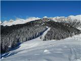
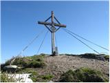
 | Urbas - Weinasch/Vajnež
Vajnež is the highest peak of Belščica, a subrange located west of the better-known Stol. The summit features a cross and both Slovenian and Aust...
2 h 25 min |
| Olipova planina - Weinasch/Vajnež (via Hrašenska planina)
Vajnež is the highest peak of Belščica, a subrange located west of the better-known Stol. The summit features a cross and both Slovenian and Aust...
2 h 50 min |
| Valvasorjev dom pod Stolom - Weinasch/Vajnež
Vajnež is the highest peak of Belščica, a subrange located west of the better-known Stol. The summit features a cross and both Slovenian and Aust...
3 h 30 min |
 | Planina Ravne - Veliki vrh (Veža) (via Dleskovec)
Veliki Vrh is a 2,110-metre-high mountain located in the central part of the Dleskovec Plateau. From the summit, where there are two registration...
2 h 45 min |
 | Javorje - Šija (via Kratki plaz)
Šija is located above the Vogel ski resort in the Lower Bohinj Mountains. From the summit, there is a nice view of the neighboring peaks in the s...
2 h 40 min |
 | Gate (Belca) - Mallestiger Mittagskogel (by road)
Ostra peč, known in German as Mallestiger Mittagskogel, is an 1801 m high mountain located on the northern side of the main Karawanks ridge. From...
3 h 25 min |
 | Srednji vrh - Mallestiger Mittagskogel (Via Grajšca)
Ostra peč, known in German as Mallestiger Mittagskogel, is an 1801 m high mountain located on the northern side of the main Karawanks ridge. From...
3 h 10 min |
 | Urbas - Potoški Stol
Potoški Stol is located between Stol and Vajnež on the border with Austria. A cross stands just a few metres below the grassy summit. The finest ...
2 h 15 min |
| Olipova planina - Potoški Stol
Potoški Stol is located between Stol and Vajnež on the border with Austria. A cross stands just a few metres below the grassy summit. The finest ...
2 h 40 min |
 | Valley of stream Žep - Komen
At 1684 meters, Komen is the highest peak in the Smrekovec mountain range, which borders between Styria and Carinthia. In good weather, the summi...
2 h 30 min |
 | Smrečje - Pečovnik (by road)
Pečovnik is a 1640-meter-high peak situated in the ridge of mountains between Košuta and Virnikov Grintovec. From the partly vegetated peak, a ni...
2 h 35 min |
 | Podnar / Bodenbauer - Ovčji vrh (Kozjak) / Geissberg (Kosiak) (via Karweg and southeast path)
Ovčji Vrh or Kozjak, known in German as Geissberg or Kosiak, is a 2024 m high peak located north of the main Karawanks ridge. Rising above Celovš...
2 h 45 min |
| Podnar / Bodenbauer - Ovčji vrh (Kozjak) / Geissberg (Kosiak) (via Karweg and southwest path)
Ovčji Vrh or Kozjak, known in German as Geissberg or Kosiak, is a 2024 m high peak located north of the main Karawanks ridge. Rising above Celovš...
3 h |
 | Rudnik v Topli - Petzen (Kordeschkopf) (Peca (Kordeževa glava)) (via Knipsovo sedlo)
Kordeževa glava, better known as Peca, is the highest peak of the Peca range. It is located on the border with Austria above the Mežiška dolina v...
2 h 45 min |
 | Planina Kuk - Žabiški Kuk (via planina Razor)
Žabiški Kuk is located on the southern side ridge of the Lower Bohinj Mountains near the more renowned Vogel and above Planina Razor. From the su...
3 h |
 | Planina Kuk - Vrh Planje (above Globoko)
Vrh Planje is a less prominent peak in the ridge of the Lower Bohinj Mountains, which has been increasingly visited lately. Vrh Planje (above Glo...
2 h 45 min |
 | Planina Ravne - Velika Zelenica (via Dleskovec)
Velika Zelenica is the highest peak of the Dleskovška plateau, offering panoramic views accordingly. The nearby Ojstrica stands out most prominen...
2 h 45 min |
 | NC Planica - Glave (by ski jumping hill)
Glave is an indistinct side ridge of Ponca, rising steeply west of Planica. Maps incorrectly label its highest peak (1,760 m) as Ovčja stran; tha...
2 h 30 min |
| Rateče (Ledine) - Glave
Glave is an indistinct side ridge of Ponca, rising steeply west of Planica. Maps incorrectly label its highest peak (1,760 m) as Ovčja stran; tha...
2 h 50 min |
 | Pecol - Cima di Terrarossa
Špik Hude police is a 2431-meter-high panoramic peak (new LiDAR measurement; this height will also be shown on newer maps, while older maps still...
2 h 45 min |
 | Markova raven - Krvavec (on unmarked path via Razor)
Krvavec is a 1,853-meter-high peak located in the heart of the eponymous ski resort. From the summit, which is crisscrossed with cable cars, ther...
2 h 45 min |
 | Rutarski gozd - Jehlc (Špičasta kupa)
Different maps list various names for Jehlc, which also vary in elevation. Locals call the peak Jehlc (1625 m), while newer maps show Jehelc and ...
2 h |
 | Korensko sedlo - Kamnati vrh/Steinberg (via Jerebikovec)
Kamnati vrh is a 1621 m high mountain located north of Kranjska Gora. From the grassy summit, where a bench stands, there is no view due to the n...
2 h |
 | Rudnik v Topli - Končnikov vrh (Peca)
Končnikov vrh (German: Knieps) is a 2109 m high peak situated in the central part of Peca. From the grassy summit, there is a beautiful view of t...
2 h 30 min |
 | Rudnik v Topli - Velika glava (Peca)
Velika glava is a peak in the Peca range, located between Kordeževa glava and Končnikov vrh. From the summit, which borders Austria, a beautiful ...
2 h 30 min |
| Koprivna (Kumer) - Velika glava (Peca) (via Knipsovo sedlo)
Velika glava is a peak in the Peca range, located between Kordeževa glava and Končnikov vrh. From the summit, which borders Austria, a beautiful ...
3 h 10 min |
 | Spodnje Danje - Altemaver (Ratitovec)
Altemaver (Ratitovec), at 1,678 meters, is the highest peak of Ratitovec. From its grassy summit, there is a beautiful view of the Julian Alps, J...
2 h 30 min |
 | Srednji Vrh - Maloško poldne / Mallestiger Mittagskogel
Maloško poldne, or Mallestiger Mittagskogel in German, is a 1,823-meter-high peak on the border between Slovenia and Austria, precisely between T...
2 h 55 min |
 | Gate (Belca) - Maloško poldne / Mallestiger Mittagskogel (by road)
Maloško poldne, or Mallestiger Mittagskogel in German, is a 1,823-meter-high peak on the border between Slovenia and Austria, precisely between T...
3 h 10 min |
 | Dom Pristava in Javorniški Rovt - Mala Golica
Mala Golica is a less distinct peak located east of Krvavka. From its grassy summit, there is a nice view of the Dravska dolina, Struško, parts o...
2 h 5 min |
 | Vas na Skali - Čisti vrh
Čisti vrh is a 1875 m high mountain located north of the Špičje ridge, more precisely on a panoramic elevation above the Čez Drt saddle. From the...
3 h 30 min |
 | Planina Blato - Krsteniški Stog (čez Krsteniški preval)
Krsteniški Stog, or Mali Stog, is a 1879 m high mountain rising steeply above the Krstenica mountain pasture. From the summit, where a stone cair...
2 h 25 min |
 | Srednji Vrh - Zajčnik
Zajčnik (also Blekova) is a 1746-meter-high peak situated northeast of Vošca. From the partly vegetated summit, which borders Slovenia and Austri...
2 h 10 min |
 | Vrh Bače - Rušni vrh
Rušni vrh is a 1,786-meter-high peak located east of Črna Prst. From the summit, which features a border stone from the old Rapallo border, a bea...
3 h |
 | Spodnje Danje - Kremant (Ratitovec)
Kremant is a 1,654 m high peak located on the western part of Ratitovec. From the summit, where a stamp is attached to a metal pole, a nice view ...
2 h 30 min |
 | Srnjak - Grpišca
Grpišca is a 1,676 m high grassy peak located in the main ridge of the Karavanke, more precisely between Kamnati vrh and Vošca. From the summit, ...
2 h |
 | Srnjak - Tamarča
Tamarča is a lesser-known peak located northwest of Vošca. From its summit, surrounded by larch forest, a nice view opens up onto the Martuljek m...
2 h 30 min |
 | Carbonin - Knollkopf / Col Rotondo dei Canope
The 2204 m high Knollkopf / Col Rotondo dei Canope is located in Fanes-Sennes-Prags Nature Park. Mostly covered in dwarf pines, it features a cro...
3 h |
 | Šajda / Schaidasattel - Kravji vrh / Kuhberg (via Obirsko sedlo)
Kravji vrh / Kuhberg is a two-thousander on the Obir with two approximately equally high peaks. Apart from dwarf pines, there is nothing on the h...
2 h 45 min |
 | Šajda / Schaidasattel - Kravji vrh / Kuhberg (steep path)
Kravji vrh / Kuhberg is a two-thousander on the Obir with two approximately equally high peaks. Apart from dwarf pines, there is nothing on the h...
2 h 30 min |
 | Podkoren - Visoka Bavha
Visoka Bavha is a 1,650-meter-high peak located on the border ridge of the Karawanks. The view from the summit is better towards the Austrian sid...
2 h |
 | Srednji Vrh - Bele peči (Lepi vrh) (via Železnica)
Bele peči, properly also Peči or Na Pečeh (maps sometimes show Lepi vrh, which is incorrect Lepi vrh is actually a forested shoulder at the 1,47...
2 h 30 min |
| Srednji Vrh - Bele peči (Lepi vrh) (via valley of stream Žlebnica)
Bele peči, properly also Peči or Na Pečeh (maps sometimes show Lepi vrh, which is incorrect Lepi vrh is actually a forested shoulder at the 1,47...
2 h 45 min |
 | Javorje - Gradovec (path over Glin)
Gradovec is a 1,692-meter-high peak located north of the ridge of Spodnje Bohinjske gore, specifically above the mountain pasture Poljana. From t...
3 h 10 min |
 | Concentration camp - Hajnžev Praprotnik / Zeller Prapotnik
Hajnžev Praprotnik is a 1,727-metre peak on the Austrian side of the Karawanks, more precisely between Košutica and the settlement of Sele-Zvrhnj...
3 h 15 min |
| Vranček - Hajnžev Praprotnik / Zeller Prapotnik
Hajnžev Praprotnik is a 1,727-metre peak on the Austrian side of the Karawanks, more precisely between Košutica and the settlement of Sele-Zvrhnj...
3 h 20 min |
 | Slovenji Plajberk / Windisch Bleiberg - Kosmatica / Kosmatitza
Kosmatica / Kosmatitza is a 1,659-meter-high peak entirely on the Austrian side of the Karawanks, north of Vrtača. From the summit, which is part...
3 h |
 | St. Vinzenz (St. Vinzenz) - Kleinalpl
Kleinalpl is a panoramic expansive grassy peak in the Golica/Koralpe range from which beautiful views extend far to the west....
3 h 35 min |
 | Unterauerlinger Hütte - Peterer Riegel (by grazing fence)
Peterer Riegel is a panoramic peak above the Peterer Sattel saddle. From the summit, where a cross stands and a bench sits below it, a beautiful ...
3 h 35 min |
 | Unterauerlinger Hütte - Peterer Riegel (via Peterer Alm)
Peterer Riegel is a panoramic peak above the Peterer Sattel saddle. From the summit, where a cross stands and a bench sits below it, a beautiful ...
3 h 40 min |
 | Alpengasthof Scheikl - Hohe Veitsch (up along the southern ridge)
Hohe Veitsch is the highest peak of the Veitsch mountain range, located in the eastern part of the Northern Limestone Alps. From the summit, a be...
2 h 35 min |
 | Aflenz Kurort (Bürgergraben) - Hochstein (at Mitteralm) (via Windgrube)
Hochstein is a scenic summit with a cross and summit register box in the Hochschwab mountain group, between Windgrube peak and the Mitteralm plat...
3 h 35 min |
 | Aflenz Kurort (Bürgergraben) - Schönleitenhaus (Windgrube) (on southern ridge)
The Schönleitenhaus hut is located just a few meters below the Windgrube summit. From the hut or the summit, there is a beautiful view of the sur...
3 h |