 | Bistriška planina - Dobrča
Dobrča is a 1634-metre mountain located between Begunje and Tržič. From the summit, which has a registration box with a stamp, the view opens onl...
1 h 30 min |
 | Hibje - Dobrča (by road)
Dobrča is a 1634-metre mountain located between Begunje and Tržič. From the summit, which has a registration box with a stamp, the view opens onl...
1 h 45 min |
 | Črni Kal - Blegoš (by road, via hut)
Blegoš is a 1,562-metre-high mountain located between the Selška Sora and Poljanska Sora rivers. From the grassy summit, where there is a stamp a...
1 h 30 min |
 | Črni Kal - Blegoš (direct way)
Blegoš is a 1,562-metre-high mountain located between the Selška Sora and Poljanska Sora rivers. From the grassy summit, where there is a stamp a...
1 h 10 min |
 | Črni kal - Blegoš (via Prva ravan)
Blegoš is a 1,562-metre-high mountain located between the Selška Sora and Poljanska Sora rivers. From the grassy summit, where there is a stamp a...
1 h 20 min |
 | Hunting cottage (Davča) - Porezen
Porezen is a 1,630 m high mountain situated between Davča and Baška Grapa. From the summit, where a large Partisan monument stands, a beautiful v...
1 h 45 min |
 | Podhočar - Porezen
Porezen is a 1,630 m high mountain situated between Davča and Baška Grapa. From the summit, where a large Partisan monument stands, a beautiful v...
1 h 50 min |
 | Rateče - Ofen/Peč (footpath)
Peč (also known as Tromeja; in Italian Monte Forno, in German Dreiländereck or Ofen) is a 1508 m high peak located at the tripoint between Sloven...
1 h 40 min |
 | Rateče - Ofen/Peč (eastern path, past bivouac and on footpath)
Peč (also known as Tromeja; in Italian Monte Forno, in German Dreiländereck or Ofen) is a 1508 m high peak located at the tripoint between Sloven...
1 h 45 min |
| Rateče - Ofen/Peč (eastern path, past bivouac and on mule track)
Peč (also known as Tromeja; in Italian Monte Forno, in German Dreiländereck or Ofen) is a 1508 m high peak located at the tripoint between Sloven...
1 h 50 min |
 | Javorje - Stari vrh (via Koča na Starem vrhu)
Stari Vrh is a 1,217-metre-high mountain located above the ski resort of the same name. There is no view from the summit itself due to the forest...
1 h 35 min |
 | Javorje - Stari vrh (via Prehodi)
Stari Vrh is a 1,217-metre-high mountain located above the ski resort of the same name. There is no view from the summit itself due to the forest...
1 h 30 min |
 | Zgornja Sorica - Dravh
Dravh is a 1,547-metre-high peak situated between Sorica and Soriška Planina. From the unforested summit a beautiful view opens across the Škofja...
1 h 30 min |
 | Zgornja Sorica - Lajnar
Lajnar is a 1,549-metre-high mountain located north of Soriška Planina. From the summit, which is also the highest point of the ski resort, a bea...
1 h 40 min |
 | Eko koča Nanos (Lovska koča Vojkovo) - Vojkova koča na Nanosu
Vojkova koča is located on the southern edge of the high karst Nanos plateau, near Pleša. This is the prominent peak with television transmitters...
1 h 50 min |
 | Kramarica - Smrekovec (via Bukov stan)
Smrekovec is a mountain of volcanic origin on the eastern edge of the Smrekovec mountain range. The wide grassy summit features a pyramid with a ...
1 h 30 min |
| Kramarica - Smrekovec (by road)
Smrekovec is a mountain of volcanic origin on the eastern edge of the Smrekovec mountain range. The wide grassy summit features a pyramid with a ...
1 h 30 min |
 | Krnica - Kucelj (on Čaven) (via Veliki Rob)
Kucelj is located on the southern slopes of the Trnovski Forest, northwest of the Vipava Valley. From the bare summit, where a cross stands, ther...
1 h 40 min |
 | Predmeja - Veliki Modrasovec
Veliki Modrasovec is located on the southern part of the Trnovski Forest near Predmeja. On the summit stands an old military building, which we m...
1 h 40 min |
| Predmeja (tunnels) - Veliki Modrasovec
Veliki Modrasovec is located on the southern part of the Trnovski Forest near Predmeja. On the summit stands an old military building, which we m...
1 h 55 min |
 | Mala Lazna - Mali Golak
Mali Golak is the highest peak in the Golaki group at 1495 meters above sea level and at the same time the highest point of the entire Trnovski g...
1 h 25 min |
 | Kozarnice - Mali Golak
Mali Golak is the highest peak in the Golaki group at 1495 meters above sea level and at the same time the highest point of the entire Trnovski g...
1 h 5 min |
| Bevški vrh - Mali Golak
Mali Golak is the highest peak in the Golaki group at 1495 meters above sea level and at the same time the highest point of the entire Trnovski g...
1 h 35 min |
 | Brneško sedlo - Velika Kopa
Velika Kopa is a 1542-meter-high peak located between Grmovškov dom and the nearby Mala Kopa. From the top, which is only 1 meter lower than the ...
1 h 50 min |
| Koča Planinc - Velika Kopa
Velika Kopa is a 1542-meter-high peak located between Grmovškov dom and the nearby Mala Kopa. From the top, which is only 1 meter lower than the ...
1 h 50 min |
 | Kozarnice - Srednji Golak (via Mali Golak)
Srednji Golak is located between Mali and Veliki Golak on the plateau of Trnovski gozd above Predmeja. The peak is covered with dwarf pines, and ...
1 h 50 min |
 | Grda draga - Mali Snežnik
Mali Snežnik is a peak on the western ridge of Snežnik. Covered with dwarf pines, the summit offers beautiful views of the neighboring Veliki Sne...
1 h 30 min |
 | Koča na Naravskih ledinah - Uršlja gora (Plešivec)
Uršlja gora, or Plešivec, is a panoramic mountain between Slovenj Gradec and Črna na Koroškem. At or just below the summit stands the Church of S...
1 h 45 min |
 | St. John the Baptist on Ojstrica - Huhnerkogel/Košenjak
Košenjak is located north of Dravograd and the Drava River on the border with neighbouring Austria. Access to Košenjak is possible on foot or by ...
1 h 30 min |
 | Avsa - Mrzli vrh (on Matajur) (old path)
Mrzli vrh is a 1358-meter-high peak located in the Matajur range. From the summit, where there is a panorama board and a summit register box with...
1 h 25 min |
 | Plajberški graben / Bleiberger Graben - Sinacher Gupf / Psinski vrh
Sinski vrh (mostly marked as Psinski vrh on maps) / Sinacher Gupf is a peak north of the main Karawanks ridge, more precisely north of Stol and V...
1 h 35 min |
 | Strugarjach / Strugarje - Sinacher Gupf / Psinski vrh
Sinski vrh (mostly marked as Psinski vrh on maps) / Sinacher Gupf is a peak north of the main Karawanks ridge, more precisely north of Stol and V...
1 h 30 min |
 | Čemšenik - Črni vrh (Čemšeniška planina)
Črni vrh is the highest peak of Čemšeniška planina and, at 1,204 m, the second-highest peak in Posavsko hribovje. The summit has a logbook box bu...
1 h 30 min |
 | Planinski dom Vrhe - Črni vrh (Čemšeniška planina)
Črni vrh is the highest peak of Čemšeniška planina and, at 1,204 m, the second-highest peak in Posavsko hribovje. The summit has a logbook box bu...
1 h 30 min |
 | Ljubelj - Polna peč
Polna peč (also marked as Ravna peč on maps) is situated above the Ljubelj tunnel. From the somewhat precipitous summit there is a nice view of t...
1 h 15 min |
 | Bučan - Polna peč
Polna peč (also marked as Ravna peč on maps) is situated above the Ljubelj tunnel. From the somewhat precipitous summit there is a nice view of t...
1 h 30 min |
 | Lome - Javornik (above Črni Vrh)
Javornik is a forested peak located southeast of Črni Vrh. In 1972, a wooden observation tower was built on it, rising above the treetops and off...
1 h 5 min |
| Črni Vrh (Grom) - Javornik (above Črni Vrh)
Javornik is a forested peak located southeast of Črni Vrh. In 1972, a wooden observation tower was built on it, rising above the treetops and off...
1 h 15 min |
 | Mala Učka - Vojak
Vojak, at 1401 m, is the highest peak of Učka, a range rising steeply above the eastern Istrian coast. From the summit, which features a stone ob...
1 h 15 min |
 | Platak - Snježnik (via grlo)
Snježnik is a panoramic mountain in the western part of Gorski Kotar. From the summit there is a beautiful view of the Kvarner islands, Rijeka ba...
1 h 30 min |
| Platak - Snježnik (via crest)
Snježnik is a panoramic mountain in the western part of Gorski Kotar. From the summit there is a beautiful view of the Kvarner islands, Rijeka ba...
1 h 30 min |
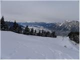
 | Bistriška planina - Šentanski vrh
Šentanski vrh, located in the Dobrča range just five minutes from the main peak, offers a nice view of the central Karawanks, the Storžič group, ...
1 h 35 min |
 | Preval Vrh Ravni - Kojca
Kojca is a panoramic peak rising south of Baška grapa. From the summit, where there is a haystack, fine views extend over the Lower Bohinj Mounta...
1 h 20 min |
 | Zakojca - Kojca
Kojca is a panoramic peak rising south of Baška grapa. From the summit, where there is a haystack, fine views extend over the Lower Bohinj Mounta...
1 h 45 min |
 | Orehek - Kojca
Kojca is a panoramic peak rising south of Baška grapa. From the summit, where there is a haystack, fine views extend over the Lower Bohinj Mounta...
1 h 55 min |
| Jesenica - Kojca
Kojca is a panoramic peak rising south of Baška grapa. From the summit, where there is a haystack, fine views extend over the Lower Bohinj Mounta...
1 h 45 min |
 | Koča na Starem vrhu - Mladi vrh (via Stari vrh)
Mladi vrh is the higher neighbor of the better-known Stari vrh, separated from it by a saddle. Covered in sparse beech forest, the summit offers ...
1 h 40 min |
 | Javorje - Mladi vrh (via Prehodi)
Mladi vrh is the higher neighbor of the better-known Stari vrh, separated from it by a saddle. Covered in sparse beech forest, the summit offers ...
1 h 45 min |
 | Podkraj - Sveti Duh (Hrušica)
The Church of the Holy Spirit is located just a few meters below the summit of Sveti Duh on the slopes of the forested Hrušica, in the range betw...
1 h 15 min |
 | Koča na planini Stador - Kobilja glava
Kobilja glava is a 1,475-meter-high peak located east of Tolmin. From the summit, where a cross stands, there is a beautiful view of Krn, the ran...
1 h 15 min |
 | Prtovč - Gladki vrh (Ratitovec) (via Razor)
Gladki vrh (Ratitovec), at 1,667 meters, is the most visited peak in the Ratitovec range. From its bare summit, which features a panorama board, ...
1 h 35 min |
| Prtovč - Gladki vrh (Ratitovec) (via Po(v)den)
Gladki vrh (Ratitovec), at 1,667 meters, is the most visited peak in the Ratitovec range. From its bare summit, which features a panorama board, ...
1 h 35 min |
| Torka - Gladki vrh (Ratitovec)
Gladki vrh (Ratitovec), at 1,667 meters, is the most visited peak in the Ratitovec range. From its bare summit, which features a panorama board, ...
1 h 20 min |
 | Prtovč - Altemaver (Ratitovec) (via Razor)
Altemaver (Ratitovec), at 1,678 meters, is the highest peak of Ratitovec. From its grassy summit, there is a beautiful view of the Julian Alps, J...
1 h 50 min |
| Prtovč - Altemaver (Ratitovec) (via Po(v)den)
Altemaver (Ratitovec), at 1,678 meters, is the highest peak of Ratitovec. From its grassy summit, there is a beautiful view of the Julian Alps, J...
1 h 50 min |
| Torka - Altemaver (Ratitovec)
Altemaver (Ratitovec), at 1,678 meters, is the highest peak of Ratitovec. From its grassy summit, there is a beautiful view of the Julian Alps, J...
1 h 35 min |
 | Zgornje Danje - Altemaver (Ratitovec)
Altemaver (Ratitovec), at 1,678 meters, is the highest peak of Ratitovec. From its grassy summit, there is a beautiful view of the Julian Alps, J...
1 h 45 min |
| Podkraj - Srednja gora (Hrušica) (east path)
Srednja gora is a 1,275 m high peak in the central part of forested Hrušica. Although the summit is wooded, just a few minutes' walk east from th...
1 h 30 min |
| Podkraj - Srednja gora (Hrušica) (west path)
Srednja gora is a 1,275 m high peak in the central part of forested Hrušica. Although the summit is wooded, just a few minutes' walk east from th...
1 h 45 min |
 | Podkraj - Streliški vrh (Hrušica) (east path)
Streliški vrh is a 1,266 m high mountain in the central part of forested Hrušica. From the partly forested summit, a nice view opens only to the ...
1 h 30 min |
| Podkraj - Streliški vrh (Hrušica) (west path)
Streliški vrh is a 1,266 m high mountain in the central part of forested Hrušica. From the partly forested summit, a nice view opens only to the ...
1 h 20 min |
 | Ravne - Cerk
Cerk, at 1,192 meters, is the highest peak of Borovška gora, a range situated between the Kolpa River valley and Goteniški Snežnik. From the summ...
1 h 30 min |
 | Jeršiče - Mali Javornik (Javorniki)
Mali Javornik is a 1219 m high mountain located in the forested ridge of Javorniki. There is no view from the summit itself due to the forest, bu...
1 h 50 min |
 | Krn - Mrzli vrh above Planina Pretovč
Mrzli vrh is a well-known battlefield from the First World War. Today, the peak is recognised as an open-air museum where numerous caverns, trenc...
1 h 30 min |
 | Zgornje Danje - Kremant (Ratitovec)
Kremant is a 1,654 m high peak located on the western part of Ratitovec. From the summit, where a stamp is attached to a metal pole, a nice view ...
1 h 45 min |
 | Dom na Paškem Kozjaku - Štrukljev vrh
Štrukljev vrh is, alongside Špik (1,108 m) and Basališče (1,272 m), one of the three main peaks of Paški Kozjak, a roughly 10 km long, narrow and...
1 h 30 min |
 | Avsa - Srednji vrh (on Matajur) (old path)
Srednji vrh is a 1,320-meter-high grassy peak located in the Matajur mountain range. From the summit, a paragliding takeoff point, there is a fin...
1 h 20 min |
 | St. John the Baptist on Ojstrica - Kozji vrh (at Košenjak)
Kozji vrh is a 1,383-meter-high peak located above Pernice; it is also the highest peak in the Municipality of Muta....
1 h 35 min |
 | Bodenbauer - Kosmatica / Kosmatitza
Kosmatica / Kosmatitza is a 1,659-meter-high peak entirely on the Austrian side of the Karawanks, north of Vrtača. From the summit, which is part...
1 h 45 min |
 | Mönichkirchen - Steinerne Stiege
Steinerne Stiege is a less prominent peak in the Wechsel range....
1 h 35 min |
 | St. Vinzenz (St. Vinzenz) - Dreieckkogel
Dreieckkogel is a 1,528-meter-high peak in the Golica/Koralpe range, north of Sobota Lake/Stausee Soboth. At the summit there is a cairn with a s...
1 h 35 min |
 | Lišnjak (road on Promina) - Čavnovka (Promina) (past hut and on footpath)
Čavnovka is the highest summit of Promina, a smaller range above the town of Drniš. There are two summits: the southern one features an antenna, ...
1 h 45 min |
 | Lišnjak (road on Promina) - Čavnovka (Promina) (past hut and on road)
Čavnovka is the highest summit of Promina, a smaller range above the town of Drniš. There are two summits: the southern one features an antenna, ...
1 h 45 min |
 | Straßegg - Hochschlag
Hochschlag is a 1580-meter-high panoramic peak located in the Fischbacher Alpen mountain group. From the summit, where a cross and a summit regis...
1 h 45 min |
 | Crossroads below Zvonik - Bitoraj
Bitoraj (also Veliki Bitoraj or Burni Bitoraj) is a 1,386-meter-high peak located south of the settlement Vrata. The peak is an HPO point. From t...
1 h 30 min |
 | Omar - Črni vrh (above Klenovica)
Črni vrh is a distinct peak situated above Klenovica. It is located near the more famous Kolovratske stijene. From the summit, which has a logboo...
1 h 45 min |