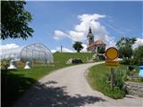
 | Rakovnik - Sveti Jakob (via Breznik)
The Church of St. James is located on a scenic hill north of the village of Topol pri Medvodah. From the summit, which features a registration bo...
1 h 50 min |
 | Gosteče - Osolnik (via Vidmovec)
Osolnik is an 858-metre-high mountain located south of Škofja Loka and west of Medvode. From the summit, where the Church of St Mohor and Fortuna...
1 h 30 min |
 | Sveta Barbara (Nova Hrastnica) - Osolnik
Osolnik is an 858-metre-high mountain located south of Škofja Loka and west of Medvode. From the summit, where the Church of St Mohor and Fortuna...
1 h 50 min |
 | Mlinše - Zasavska Sveta gora
Zasavska Sveta Gora is a popular excursion destination located between Litija and Izlake. From the summit, where the parish church of the Nativit...
1 h 30 min |
 | Vidrga - Zasavska Sveta gora (on forest footpath)
Zasavska Sveta Gora is a popular excursion destination located between Litija and Izlake. From the summit, where the parish church of the Nativit...
1 h 30 min |
| Vidrga - Zasavska Sveta gora (on a cart track)
Zasavska Sveta Gora is a popular excursion destination located between Litija and Izlake. From the summit, where the parish church of the Nativit...
1 h 30 min |
 | Mala voda - Kožljek
Kožljek is a 788 m high peak located west of Koren, more precisely above the village of Samotorica. From the summit, where there are several benc...
1 h 15 min |
 | Mala voda - Koreno
Koreno (also known as Korena) is a 729 m high hill located north of Horjul. From the summit, which features a large cross, the church of St. Moho...
1 h 15 min |
 | Srednja vas - Koreno
Koreno (also known as Korena) is a 729 m high hill located north of Horjul. From the summit, which features a large cross, the church of St. Moho...
1 h 20 min |
 | Grgar - Sveta Gora (by road)
Sveta Gora is known mainly among believers and locals. It is a well-known pilgrimage center above Nova Gorica. Believers come here from all over ...
1 h 15 min |
 | Spodnje Pirniče - Grmada (Kovačeva steza)
Grmada is a 676-meter-high mountain located west of the much more visited Šmarna gora. From the summit, which has a small takeoff area, a beautif...
1 h 10 min |
 | Briše - Mali vrh
West of Polhov Gradec, between the rivers Mala voda and Velika Božna, lies the 708-meter-high hill known as Mali vrh. From the grassy summit, whi...
1 h 5 min |
 | Sveta Barbara (Nova Hrastnica) - Sveti Ožbolt (above Zminec)
Sveti Ožbolt is situated on a panoramic rise in the north of the Polhograjski Dolomiti. There is a beautiful view toward the Škofjeloško hribovje...
1 h 40 min |
 | Planina - Petričev hrib
Petričev hrib is a peak north of Postojna and west of Planina. From the summit, which has a logbook box, there is a nice view of the Notranjska h...
1 h 30 min |
| Planina (Dolnja Planina) - Petričev hrib (via Zavrtniki)
Petričev hrib is a peak north of Postojna and west of Planina. From the summit, which has a logbook box, there is a nice view of the Notranjska h...
1 h 35 min |
| Planina (Dolnja Planina) - Petričev hrib (via Sv. Duh)
Petričev hrib is a peak north of Postojna and west of Planina. From the summit, which has a logbook box, there is a nice view of the Notranjska h...
1 h 35 min |
 | Liboje (quarry) - Kotečnik (via eastern ridge)
Kotečnik is a peak in the Posavsko hribovje, located north of Šmohor. It is a summit with two logboxes: the first on the western subpeak, offerin...
1 h 5 min |
 | Slavkov dom na Golem Brdu - Rog
Rog is an 798-meter peak above the village of Topol, just 10 minutes from St. Katarina's Church. From the summit, where a large cross once stood,...
1 h 40 min |
 | Selca - Miklavška gora (by road)
Miklavška gora is a panoramic hill situated south of Železniki and Selca. From the summit, where the Church of St. Nicholas stands, a beautiful v...
1 h 45 min |
 | Podpeč - Grmada on Mala gora
Grmada (also Grmada above Ortnek) is an 887-meter-high peak located above the village of Vrh pri Poljanah in the Mala Gora range. Just a few mete...
1 h 35 min |
 | Zgornja Rečica (Maček) - Govško brdo (past shepherd's chapel)
Govško brdo is an 811-meter-high hill located west of the village of Huda Jama above Laško. From the summit, which features a logbook box and sta...
1 h 35 min |
 | Planina (Dolnja Planina) - Grmada (Planinska gora) (via Zavrtniki)
Grmada is an 873-meter-high peak rising west of Planinsko polje. Although the summit is forested, a viewpoint just below it offers a stunning vie...
1 h 5 min |
| Planina (Dolnja Planina) - Grmada (Planinska gora) (via Sv. Duh)
Grmada is an 873-meter-high peak rising west of Planinsko polje. Although the summit is forested, a viewpoint just below it offers a stunning vie...
1 h 5 min |
 | Olševek - Štefanja gora (via Apnišče)
Štefanja gora, where the Church of St. Stephen stands, is located above Cerklje na Gorenjskem. Just a few tens of meters below the summit lies th...
1 h 15 min |
 | Preddvor - Štefanja gora (on footpath)
Štefanja gora, where the Church of St. Stephen stands, is located above Cerklje na Gorenjskem. Just a few tens of meters below the summit lies th...
1 h 20 min |
 | Polhov Gradec - Mala Grmada (via Ravnek and via Sveta Uršula)
Mala Grmada is an 853-meter-high peak located southwest of the slightly higher Polhograjska Grmada. From the summit, a beautiful view opens up ov...
1 h 35 min |
| Polhov Gradec (Božna) - Mala Grmada (via Sveta Uršula)
Mala Grmada is an 853-meter-high peak located southwest of the slightly higher Polhograjska Grmada. From the summit, a beautiful view opens up ov...
1 h 10 min |
 | Rakovnik - Sveti Florijan (Tehovec) (via Breznik)
The Church of St. Florijan is a subsidiary church located in the village of Tehovec above Medvode. From the church, first mentioned in 1548, a ni...
1 h 20 min |
 | Spodnja Idrija - Cerkovni vrh
Cerkovni Vrh rises broad-shouldered above Spodnja Idrija. From the summit, beautiful views open up onto local peaks such as Kobalove Planine, Jel...
1 h 15 min |
 | Zazid - Golič (direct way)
Golič is a grassy ridge extending from Kojnik to the Slovenian-Croatian border and continuing as the Žbevnica ridge on the Croatian side. Due to ...
1 h 45 min |
 | Nemilje - Sveti Mohor (Zabrekve)
The Church of St. Mohor is located on a 952 m high hill between Zgornja Besnica and Selci. From the church or its nearby surroundings, there is a...
1 h 20 min |
 | Selca - Sveti Mohor (Zabrekve)
The Church of St. Mohor is located on a 952 m high hill between Zgornja Besnica and Selci. From the church or its nearby surroundings, there is a...
1 h 40 min |
 | Knape - Sveti Mohor (Zabrekve) (via Hudi Laz, Flandrova pot)
The Church of St. Mohor is located on a 952 m high hill between Zgornja Besnica and Selci. From the church or its nearby surroundings, there is a...
1 h 40 min |
 | Nemilje - Sveti Mohor (Zabrekve) (via Prevoje)
The Church of St. Mohor is located on a 952 m high hill between Zgornja Besnica and Selci. From the church or its nearby surroundings, there is a...
1 h 35 min |
 | Brezovica - Sveti Primož in Felicijan (Jamnik)
The Church of St. Primož and Felicijan at Jamnik is located on a scenic grassy ridge rising between Kropa and Podblica. From the church or its ne...
1 h 20 min |
| Češnjica pri Kropi - Sveti Primož in Felicijan (Jamnik) (via Berigla)
The Church of St. Primož and Felicijan at Jamnik is located on a scenic grassy ridge rising between Kropa and Podblica. From the church or its ne...
1 h 20 min |
 | Ribenski most - Tolsti vrh (Talež)
Tolsti vrh is an 883 m high hill located south of Bled, more precisely above the Talež hunting lodge. From the summit, which descends steeply tow...
1 h 15 min |
 | Selski most - Tolsti vrh (Talež)
Tolsti vrh is an 883 m high hill located south of Bled, more precisely above the Talež hunting lodge. From the summit, which descends steeply tow...
1 h 15 min |
 | Puščava - Lobnikov vrh
Lobnikov vrh is a forested peak above the Dravska dolina valley, located between the settlements of Fala and Ruta. From the east, due to its remo...
1 h 20 min |
| Fala Grad - Lobnikov vrh
Lobnikov vrh is a forested peak above the Dravska dolina valley, located between the settlements of Fala and Ruta. From the east, due to its remo...
1 h 15 min |
| Nevlje pri Kamniku - Vovar
A viewless hill in front of the Kamnik mountains. In recent times, due to storms, it is crisscrossed with cart tracks for log extraction.Below th...
1 h 30 min |
 | Žiri - Javorč
Javorč is a 901-meter-high peak located northeast of Žiri. The summit, featuring a logbox with a logbook, lies at the edge of a larger clearing, ...
1 h 15 min |
 | Log - Pečke (by road)
Pečke is an easily accessible peak that has seen fewer visitors lately, located north of the main Pohorje ridge. It gets more visits only on May ...
1 h 5 min |
 | Preddvor - Apnišče (on footpath)
Apnišče is a 740 m high mountain between Možjanca and Štefanja gora. It is the highest point of the Šenčur municipality. The forested summit offe...
1 h 15 min |
 | Jamce - Podrta gora above Ajdovščina
Podrta gora above Ajdovščina, also Podrta gora above Šturje, is a mountain rising above the Vipava Valley. Some time ago, a large piece of wall b...
1 h 20 min |
 | Kokra (resting place Kokra-sotočje) - Skutman
Skutman is a lesser-known peak above the left bank of the Kokra River and north of Štefanja Gora. The summit is marked by a metal plaque reading ...
1 h 10 min |
 | Mežica - Andrejev vrh (by cart track)
Andrejev vrh is a forest-covered peak located between Mežica and Leše. On the summit there is a bench and a summit register box with a logbook....
1 h 15 min |
| Mežica - Andrejev vrh (past the chapel)
Andrejev vrh is a forest-covered peak located between Mežica and Leše. On the summit there is a bench and a summit register box with a logbook....
1 h 20 min |
| Poljana - Andrejev vrh (over Volinjak and on cart track)
Andrejev vrh is a forest-covered peak located between Mežica and Leše. On the summit there is a bench and a summit register box with a logbook....
1 h 50 min |
| Poljana - Andrejev vrh (via Volinjak and past the chapel)
Andrejev vrh is a forest-covered peak located between Mežica and Leše. On the summit there is a bench and a summit register box with a logbook....
1 h 55 min |
| Poljana - Andrejev vrh (past Leše churches and on cart track)
Andrejev vrh is a forest-covered peak located between Mežica and Leše. On the summit there is a bench and a summit register box with a logbook....
1 h 50 min |
| Poljana - Andrejev vrh (via Leše churches and via chapel)
Andrejev vrh is a forest-covered peak located between Mežica and Leše. On the summit there is a bench and a summit register box with a logbook....
1 h 55 min |
 | Selca - Sleme (Površnica)
Sleme is a panoramic peak located between Rudno, Dražgoše, and Lajše. From the summit, where transmitters are located, there is a nice view of th...
1 h 35 min |
| Železniki - Sleme (Površnica) (via Štalca)
Sleme is a panoramic peak located between Rudno, Dražgoše, and Lajše. From the summit, where transmitters are located, there is a nice view of th...
1 h 35 min |
 | Selca - Sveti Križ above Selca
The Church of the Holy Cross above Selca is situated on a panoramic hill from which a beautiful view opens up over part of the Škofjeloško hribov...
1 h 15 min |
| Železniki - Sveti Križ above Selca (via Štalca)
The Church of the Holy Cross above Selca is situated on a panoramic hill from which a beautiful view opens up over part of the Škofjeloško hribov...
1 h 15 min |
 | Ravne na Koroškem - Brinjeva gora (above Prevalje)
Brinjeva gora is a popular excursion spot for Prevalje locals, located between the Meža River and Zelenbreški Stream. On the summit stands a smal...
1 h 10 min |
 | Pristava - Planica (Paragliding site Gozd)
Planica is a 926-meter peak located above the village of Gozd. From the summit, where the JPK Kriška gora cottage stands, a nice view opens up ov...
1 h 20 min |
 | Rudnik pri Radomljah - Tolsta gora
Tolsta gora is a 734-meter-high mountain located above the settlement of Vrhpolje pri Kamniku. From the summit, where a cairn stands, there is no...
1 h 25 min |
| Pravdan - Tolsta gora (via Čeh)
Tolsta gora is a 734-meter-high mountain located above the settlement of Vrhpolje pri Kamniku. From the summit, where a cairn stands, there is no...
1 h 45 min |
 | Rudnik pri Radomljah - Vrtače (via Lancar)
Vrtače is a 758-meter-high peak located above the village of Zgornje Palovče. The summit is overgrown with forest, but from a clearing slightly b...
1 h 30 min |
| Pravdan - Vrtače (via Zgornje Palovče)
Vrtače is a 758-meter-high peak located above the village of Zgornje Palovče. The summit is overgrown with forest, but from a clearing slightly b...
1 h 45 min |
 | Dravograd (Meža) - Sveti Danijel (above Trbonje)
The Church of St. Daniel is situated on the edge of the Sveti Danijel settlement, above Trbonje. From the church, a nice view opens up towards Po...
1 h 30 min |
 | Škofja Loka - Vrh soteske (Križna gora)
Vrh soteske is a 735 meters high peak, which is situated on the southwestern part of Križna gora. From the top, which is overgrown by the forest,...
1 h 25 min |
| Vešter - Vrh soteske (Križna gora)
Vrh soteske is a 735 meters high peak, which is situated on the southwestern part of Križna gora. From the top, which is overgrown by the forest,...
1 h 15 min |
 | Grahovo ob Bači (Brelih) - Črvov vrh (via Žrelo)
Črvov Vrh, also known as Črvov Grič, is the highest peak of the Šentviška Planota at 974 metres. The plateau rises above the right bank of the Id...
1 h 50 min |
| Grahovo ob Bači (Brelih) - Črvov vrh (via homestead Pušnik)
Črvov Vrh, also known as Črvov Grič, is the highest peak of the Šentviška Planota at 974 metres. The plateau rises above the right bank of the Id...
1 h 40 min |
 | Grahovo ob Bači (Brelih) - Bukovski vrh (via Žrelo)
Bukovski Vrh (918 m) lies above the settlement of Bukovski Vrh, more precisely above the Pri Pircu homestead. From the grassy summit there is a f...
1 h 40 min |
 | Hotavlje - Vrh Slajke
Vrh Slajke is a 790-metre hill above Hotavlje, specifically above the right bank of the Kopačnica. From the summit, where an antenna tower stands...
1 h 15 min |
| Hotavlje - Vrh Slajke (via Bela)
Vrh Slajke is a 790-metre hill above Hotavlje, specifically above the right bank of the Kopačnica. From the summit, where an antenna tower stands...
1 h 30 min |
| Podgora - Vrh Slajke
Vrh Slajke is a 790-metre hill above Hotavlje, specifically above the right bank of the Kopačnica. From the summit, where an antenna tower stands...
1 h 25 min |
 | Ledinica - Krog (Ledinski grič)
Krog is a 940-metre-high peak on the western part of the Ledinski grič ridge, between the streams Jerešča and Ledinščicaboth left tributaries of ...
1 h 15 min |
 | Žiri - Krog (Ledinski grič)
Krog is a 940-metre-high peak on the western part of the Ledinski grič ridge, between the streams Jerešča and Ledinščicaboth left tributaries of ...
1 h 50 min |
 | Hotavlje - Špik (Vranškov grič) (via Bela)
Špik (also marked as Vranškov grič on maps) is a 908 m high mountain west of Hotavlje. The summit lies in forest, but a grassy subpeak offers fin...
1 h 50 min |
| Podgora - Špik (Vranškov grič)
Špik (also marked as Vranškov grič on maps) is a 908 m high mountain west of Hotavlje. The summit lies in forest, but a grassy subpeak offers fin...
1 h 45 min |
 | Hotavlje - Kucelj (above Kopačnica) (via Srednje Brdo)
Kucelj is a 920-meter-high peak located above the left bank of Kopačnica and the settlement of the same name. At the summit there is a bench, a t...
1 h 55 min |
 | Vas (sports field) - Sveti Jurij (Remšnik)
The Church of St. Jurij is located on a panoramic hill in the Remšnik settlement, which lies on the slopes of Kozjak. Opposite the church, next t...
1 h 45 min |
 | Zreče (Terme Zreče) - Golek (steep path)
Golek is a 769-meter-high peak located northwest of Zreče. The summit has a logbook box with book and stamp, plus a bench; a short distance (a fe...
1 h 20 min |
 | Ožbalt (dam on stream Črmenica) - Grilov vrh (on cart track)
Grilov vrh is a panoramic peak above the left bank of the Drava River, east of Ožbalt. The summit logbook stands by the transmitters on a grassy ...
1 h 40 min |
 | Deutschfeistritz - Parmaseggkogel (via Kugelberg)
Parmaseggkogel is a 785-meter-high peak between the town of Deutschfeistritz and the municipality of Frohnleiten, northwest of Graz.A cross and s...
1 h 15 min |
 | Selnica ob Dravi - Janžev vrh
Janžev vrh is a lesser-known peak located slightly off the marked path from Selnica ob Dravi to Sveti Duh na Ostrem Vrhu. A few antennas stand on...
1 h 35 min |
| Janževa Gora - Janžev vrh (past church of St. Janez Krstnik)
Janžev vrh is a lesser-known peak located slightly off the marked path from Selnica ob Dravi to Sveti Duh na Ostrem Vrhu. A few antennas stand on...
1 h 35 min |
 | Šentjanž pri Dravogradu - Selovec (Gruberjev vrh) (past Čubej and Rudof)
Selovec, often also referred to as the adjacent slightly lower Gruberjev vrh, is located above the Bukovnik ski slope near Šentjanž pri Dravograd...
1 h 45 min |
| Šentjanž pri Dravogradu - Selovec (Gruberjev vrh) (past Napotnik and Rudof)
Selovec, often also referred to as the adjacent slightly lower Gruberjev vrh, is located above the Bukovnik ski slope near Šentjanž pri Dravograd...
1 h 45 min |