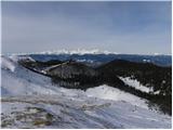
 | Šport hotel - Mrežce
Mrežce is a panoramic peak near Lipanski vrh, which is visible on the other side of the gully between the two peaks. Since the slopes towards Pok...
2 h 40 min |
 | Planina Zajavornik - Debela peč
Debela peč is a 2014 m high mountain that rises steeply above the Krma valley on one side and gently descends towards the expansive Pokljuka fore...
2 h 30 min |
| Šport hotel - Debela peč
Debela peč is a 2014 m high mountain that rises steeply above the Krma valley on one side and gently descends towards the expansive Pokljuka fore...
3 h 30 min |
 | Vrh Bače - Črna prst
On the northern slope of the summit ridge of Črna prst, black soil is visible the feature after which the mountain is named. Črna prst is renown...
3 h 10 min |
 | Pod Luknjo - Črna prst
On the northern slope of the summit ridge of Črna prst, black soil is visible the feature after which the mountain is named. Črna prst is renown...
2 h 30 min |
 | Gozd - Tolsti vrh (easier path over Kriška gora)
Tolsti vrh, located west of Storžič, is at 1715 metres also the highest peak of the Kriška gora range, which rises steeply above central Gorenjsk...
2 h 30 min |
 | Tuškov Grič - Blegoš (via Črni vrh)
Blegoš is a 1,562-metre-high mountain located between the Selška Sora and Poljanska Sora rivers. From the grassy summit, where there is a stamp a...
2 h 45 min |
 | Petrovo Brdo - Možic (via Vrh Bače)
Možic is a 1,602 m high peak located west of Soriška Planina. At the very summit there is an old military bunker bearing the name of the peak and...
2 h 30 min |
| Petrovo Brdo - Možic (via Lajnar)
Možic is a 1,602 m high peak located west of Soriška Planina. At the very summit there is an old military bunker bearing the name of the peak and...
2 h 30 min |
 | Petrovo Brdo - Porezen
Porezen is a 1,630 m high mountain situated between Davča and Baška Grapa. From the summit, where a large Partisan monument stands, a beautiful v...
2 h 30 min |
 | Tuškov Grič - Porezen (by road)
Porezen is a 1,630 m high mountain situated between Davča and Baška Grapa. From the summit, where a large Partisan monument stands, a beautiful v...
3 h 5 min |
 | Raspet - Porezen (on ridge of Cimprovka)
Porezen is a 1,630 m high mountain situated between Davča and Baška Grapa. From the summit, where a large Partisan monument stands, a beautiful v...
2 h 45 min |
 | Preval Vrh Ravni - Porezen
Porezen is a 1,630 m high mountain situated between Davča and Baška Grapa. From the summit, where a large Partisan monument stands, a beautiful v...
2 h 30 min |
 | Preval Vrh Ravni - Porezen (via Dom na Poreznu)
Porezen is a 1,630 m high mountain situated between Davča and Baška Grapa. From the summit, where a large Partisan monument stands, a beautiful v...
2 h 35 min |
 | Planina pod Golico (Betel) - Kahlkogel/Golica (via Suha saddle)
Golica is an unvegetated peak located north of Jesenice. From the summit, where a registration box is placed, there is a fine view of the western...
2 h 50 min |
 | Dom Pristava in Javorniški Rovt - Kahlkogel/Golica (via mountain hut)
Golica is an unvegetated peak located north of Jesenice. From the summit, where a registration box is placed, there is a fine view of the western...
2 h 45 min |
 | Planina Blato - Pršivec
Pršivec is a panoramic mountain above Lake Bohinj. The view is extensive in all directions: Triglav and the surrounding mountains are clearly vis...
2 h 30 min |
 | Planina Blato - Pršivec
Pršivec is a panoramic mountain above Lake Bohinj. The view is extensive in all directions: Triglav and the surrounding mountains are clearly vis...
2 h 30 min |
 | Šport hotel - Brda (east path)
Brda is a panoramic peak situated between Pokljuka and Krma. The summit has a stamp attached to a metal pole and offers a beautiful view towards ...
3 h 15 min |
 | Laško (obračališče nad vasjo) - Bašeljski vrh
Bašeljski vrh is a 1744-meter-high mountain located between Mali Grintovec and Storžič. From the summit, where there is a bench and a registratio...
2 h 35 min |
 | Erjavčev rovt - Frauenkogel/Dovška Baba (via Brvog)
Dovška Baba is a 1891-meter-high peak located on the border ridge between Slovenia and Austria. From the summit, which has a registration box and...
2 h 45 min |
 | Ljubelj - Srednji vrh (above Završnica) (via source of Završnica)
Srednji vrh is a panoramic mountain covered in dwarf pine, located between Stol, Vrtača and Begunjščica. From the summit, which drops steeply to ...
2 h 40 min |
 | Ljubelj - Srednji vrh (above Završnica) (on the slope of Vrtača)
Srednji vrh is a panoramic mountain covered in dwarf pine, located between Stol, Vrtača and Begunjščica. From the summit, which drops steeply to ...
3 h |
 | Ljubelj - Srednji vrh (above Završnica) (on a slope of Vrtača)
Srednji vrh is a panoramic mountain covered in dwarf pine, located between Stol, Vrtača and Begunjščica. From the summit, which drops steeply to ...
2 h 40 min |
 | Javorje - Rodica (marked way)
The mountain Rodica is located above Bohinj in the Lower Bohinj Mountains. From the summit there is a beautiful view over the Julian Alps and the...
2 h 45 min |
| Rutarski gozd - Rodica
The mountain Rodica is located above Bohinj in the Lower Bohinj Mountains. From the summit there is a beautiful view over the Julian Alps and the...
2 h 30 min |
 | Planina Zajavornik - Debeli vrh above Lipanca
Debeli vrh is a 1962 m high mountain located in the ridge that rises steeply above the Krma valley. From the summit, where a stamp is attached to...
2 h 30 min |
| Šport hotel - Debeli vrh above Lipanca
Debeli vrh is a 1962 m high mountain located in the ridge that rises steeply above the Krma valley. From the summit, where a stamp is attached to...
3 h 15 min |
 | Grahovše - Bela peč (via Boršt)
The mountain, known mainly among climbers, is located north of Storžič on the slopes of Konjščica. From the summit there is a beautiful view of t...
2 h 30 min |
 | Grahovše - Bela peč (via rot)
The mountain, known mainly among climbers, is located north of Storžič on the slopes of Konjščica. From the summit there is a beautiful view of t...
2 h 30 min |
 | Grahovše - Bela peč (via Rekar)
The mountain, known mainly among climbers, is located north of Storžič on the slopes of Konjščica. From the summit there is a beautiful view of t...
2 h 30 min |
 | Črnivec - Lepenatka
Lepenatka is a grassy peak located south of the 1557-metre-high Rogatec. From the summit, which has a summit register box and stamp, there is a b...
3 h 15 min |
 | Jekarica - Mali Grintovec
Mali Grintovec is a panoramic mountain located east of Storžič. From the summit, which has a summit register box, stamp, and a pleasant bench, th...
2 h 55 min |
 | Planina pod Golico - Rosenkogel/Hruški vrh
Hruški vrh is a 1776-metre-high mountain located between Dovška Baba and the lesser-known Klek. From the summit, where there is a small chapel de...
2 h 30 min |
 | Ravenska Kočna - Goli vrh (austrian way)
Goli vrh is a 1787 m high mountain situated between the Ravenska Kočna and Belska Kočna valleys. From the bare summit, which has a registration b...
2 h 30 min |
| Velacher Kotschna/Belska Kočna - Goli vrh
Goli vrh is a 1787 m high mountain situated between the Ravenska Kočna and Belska Kočna valleys. From the bare summit, which has a registration b...
2 h 45 min |
 | Baumgartnerhof - Kresišče
Kresišče is an 1839 m high peak in the main ridge of the Karawanks, specifically between Kepa and Trupejevo poldne. From the summit, where a wood...
3 h |
 | Bohinjsko sedlo - Kobla
The summit is located in the Lower Bohinj Mountains between Črna prst and Soriška planina. Directly below it is a railway tunnel connecting Bohin...
2 h 35 min |
 | Koča pri izviru Soče - Vršič vrh
Vršič is a 1,737-metre-high mountain situated between the Poštarski dom hut and the Vršič pass. From the summit, where there is a registration bo...
2 h 40 min |
 | Preval - Koprivnik
Koprivnik is a 1393-meter-high mountain located between Blegoš and Mladi vrh. From the summit, which has a registration box and a stamp, the view...
3 h 15 min |
 | Črnivec - Vivodnik
Vivodnik, at 1508 meters, is the highest peak of Menina planina, a plateau rising south of Gornji Grad. From the summit, which has a small observ...
4 h 30 min |
 | Javorje - Šija (via Zadnja Suha)
Šija is located above the Vogel ski resort in the Lower Bohinj Mountains. From the summit, there is a nice view of the neighboring peaks in the s...
2 h 30 min |
 | Koča pri izviru Soče - Sovna glava
Sovna Glava is a 1750-meter-high grassy peak situated between Prisank and the Vršič Pass. From the summit, there is a nice view of the peaks risi...
2 h 40 min |
 | Baumgartnerhof - Mallestiger Mittagskogel
Ostra peč, known in German as Mallestiger Mittagskogel, is an 1801 m high mountain located on the northern side of the main Karawanks ridge. From...
3 h 15 min |
 | Andrejev dom na Slemenu - Smrekovec
Smrekovec is a mountain of volcanic origin on the eastern edge of the Smrekovec mountain range. The wide grassy summit features a pyramid with a ...
3 h 30 min |
 | Planina Vodol - Komen
At 1684 meters, Komen is the highest peak in the Smrekovec mountain range, which borders between Styria and Carinthia. In good weather, the summi...
3 h 15 min |
 | Valley of stream Žep - Veliki Travnik (Turnovka)
Veliki Travnik, also known as Turnovka by the locals, is located on the western edge of the Smrekovec mountain range. From the summit, which has ...
2 h 45 min |
 | Bistra - Veliki Travnik (Turnovka)
Veliki Travnik, also known as Turnovka by the locals, is located on the western edge of the Smrekovec mountain range. From the summit, which has ...
3 h 45 min |
 | Gorenje pri Zrečah - Rogla
Rogla is a peak in the middle of the eponymous ski resort. The peak is forested with a small clearing on which stands a lookout tower. The tower ...
2 h 35 min |
 | Johannsenruhe - Ovčji vrh (Kozjak) / Geissberg (Kosiak) (southwest path)
Ovčji Vrh or Kozjak, known in German as Geissberg or Kosiak, is a 2024 m high peak located north of the main Karawanks ridge. Rising above Celovš...
2 h 30 min |
| Trate / Johannsenruhe - Ovčji vrh (Kozjak) / Geissberg (Kosiak) (southeast path)
Ovčji Vrh or Kozjak, known in German as Geissberg or Kosiak, is a 2024 m high peak located north of the main Karawanks ridge. Rising above Celovš...
2 h 35 min |
 | Planina Kuk - Vogel (direct way)
Many associate the name Vogel first with the Vogel ski resort near the eponymous peak. From the north, it is recognizable by its pyramidal shape,...
2 h 45 min |
| Planina Kuk - Vogel (via Globoko)
Many associate the name Vogel first with the Vogel ski resort near the eponymous peak. From the north, it is recognizable by its pyramidal shape,...
3 h 30 min |
 | Poštarski dom pod Plešivcem - Uršlja gora (Plešivec) (via Kozarnica)
Uršlja gora, or Plešivec, is a panoramic mountain between Slovenj Gradec and Črna na Koroškem. At or just below the summit stands the Church of S...
2 h 30 min |
| Poštarski dom pod Plešivcem - Uršlja gora (Plešivec) (via Kal)
Uršlja gora, or Plešivec, is a panoramic mountain between Slovenj Gradec and Črna na Koroškem. At or just below the summit stands the Church of S...
2 h 45 min |
 | Ciganija - Uršlja gora (Plešivec) (winter way)
Uršlja gora, or Plešivec, is a panoramic mountain between Slovenj Gradec and Črna na Koroškem. At or just below the summit stands the Church of S...
2 h 30 min |
 | Andrejev dom na Slemenu - Uršlja gora (Plešivec)
Uršlja gora, or Plešivec, is a panoramic mountain between Slovenj Gradec and Črna na Koroškem. At or just below the summit stands the Church of S...
2 h 45 min |
 | Koutschitz Alm/Kočiška planina - Poludnig/Poludnik
Poludnik/Poludnig is located on the eastern part of the Carnic Alps. Because there is no higher peak nearby, there is a very nice view from Polud...
3 h |
 | Žabnice / Camporosso in Valcanale - Svete Višarje / Monte Lussari
Svete Višarje / Monte Lussari is a pilgrimage site for Slavs, Germans, and Romance peoples. Already in the 16th century, the mountain was called ...
2 h 30 min |
 | Topla (Burjak) - Mala Peca
Mala Peca is the peak above the Dom na Peci mountain hut on its eastern slopes. From the summit, where a panoramic sign stands, there is a nice v...
2 h 30 min |
 | Spodnje Sleme - Govca (Olševa)
Govca is the highest peak of the Olševa range, rising above Koprivna, Solčava, and Remšenik (Remšenik/Remschenig is a valley on the Austrian side...
3 h |
 | Pod Peco / Koprein-Petzen - Govca (Olševa) (via Kumer)
Govca is the highest peak of the Olševa range, rising above Koprivna, Solčava, and Remšenik (Remšenik/Remschenig is a valley on the Austrian side...
4 h 30 min |
| Mountain hut on farm Kumer - Govca (Olševa)
Govca is the highest peak of the Olševa range, rising above Koprivna, Solčava, and Remšenik (Remšenik/Remschenig is a valley on the Austrian side...
3 h 45 min |
 | Petrovo Brdo - Krevl
Krevl is a 1515-meter-high peak situated south of the Kobla ski area, more precisely between the Kobla peak and Kravja Črna gora. From the summit...
2 h 30 min |
 | Bohinjsko sedlo - Krevl
Krevl is a 1515-meter-high peak situated south of the Kobla ski area, more precisely between the Kobla peak and Kravja Črna gora. From the summit...
2 h 50 min |
 | Avsa - Monte Mataiur/Matajur
Matajur is a panoramic mountain located on the border between Slovenia and Italy. From the summit there is a beautiful view of Kobariški or Bregi...
2 h 30 min |
 | Masseris - Monte Mataiur/Matajur
Matajur is a panoramic mountain located on the border between Slovenia and Italy. From the summit there is a beautiful view of Kobariški or Bregi...
2 h 30 min |
 | Avsa - Monte Mataiur/Matajur (old path)
Matajur is a panoramic mountain located on the border between Slovenia and Italy. From the summit there is a beautiful view of Kobariški or Bregi...
2 h 30 min |
 | Platak - Veliki Risnjak
Veliki Risnjak, at 1528 m, is the highest peak of Risnjak National Park. From the summit, which has a logbook box and stamp, there is a very nice...
3 h 30 min |
 | Windische Hohe - Kobesnock
Kobesnock is a lesser-known peak west of the massive Dobrač range. From its summit, which features a cross, there are fine views of Dobrač, the l...
2 h 45 min |
 | Windische Hohe - Tschekelnock
Čegla gora (German: Tschekelnock) rises steeply above the idyllic mountain village Venetski hrib/Windische Hohe. From its summit, with a cross, t...
2 h 30 min |
 | Libinjska kosa - Sveto brdo
Sveto brdo (1,752 m) is the second-highest peak of Velebit. Located in the southeastern part of the range, it offers beautiful views of Velebit i...
3 h 20 min |
 | Bohinjsko sedlo - Gladki vrh (Ratitovec)
Gladki vrh (Ratitovec), at 1,667 meters, is the most visited peak in the Ratitovec range. From its bare summit, which features a panorama board, ...
3 h 35 min |
 | Forestry cottage Rovtarica - Gladki vrh (Ratitovec)
Gladki vrh (Ratitovec), at 1,667 meters, is the most visited peak in the Ratitovec range. From its bare summit, which features a panorama board, ...
3 h 35 min |
 | Razglednik - Gladki vrh (Ratitovec)
Gladki vrh (Ratitovec), at 1,667 meters, is the most visited peak in the Ratitovec range. From its bare summit, which features a panorama board, ...
3 h 5 min |
 | Bohinjsko sedlo - Altemaver (Ratitovec)
Altemaver (Ratitovec), at 1,678 meters, is the highest peak of Ratitovec. From its grassy summit, there is a beautiful view of the Julian Alps, J...
3 h 15 min |
 | Forestry cottage Rovtarica - Altemaver (Ratitovec)
Altemaver (Ratitovec), at 1,678 meters, is the highest peak of Ratitovec. From its grassy summit, there is a beautiful view of the Julian Alps, J...
3 h 40 min |
 | Bitenjska planina - Altemaver (Ratitovec)
Altemaver (Ratitovec), at 1,678 meters, is the highest peak of Ratitovec. From its grassy summit, there is a beautiful view of the Julian Alps, J...
2 h 30 min |
| Razglednik - Altemaver (Ratitovec)
Altemaver (Ratitovec), at 1,678 meters, is the highest peak of Ratitovec. From its grassy summit, there is a beautiful view of the Julian Alps, J...
3 h 10 min |
 | Rotek - Altemaver (Ratitovec)
Altemaver (Ratitovec), at 1,678 meters, is the highest peak of Ratitovec. From its grassy summit, there is a beautiful view of the Julian Alps, J...
2 h 30 min |
| Soriška peč - Altemaver (Ratitovec)
Altemaver (Ratitovec), at 1,678 meters, is the highest peak of Ratitovec. From its grassy summit, there is a beautiful view of the Julian Alps, J...
3 h |
 | Montemaggiore - Punta di Montemaggiore
Breški Jalovec, or Punta di Montemaggiore in Italian, is a 1613-meter-high mountain located above the source of the Nadiža River, specifically on...
3 h |
 | Baumgartnerhof - Maloško poldne / Mallestiger Mittagskogel
Maloško poldne, or Mallestiger Mittagskogel in German, is a 1,823-meter-high peak on the border between Slovenia and Austria, precisely between T...
2 h 45 min |
 | Soriška peč - Kremant (Ratitovec)
Kremant is a 1,654 m high peak located on the western part of Ratitovec. From the summit, where a stamp is attached to a metal pole, a nice view ...
2 h 30 min |
 | Rotek - Kremant (Ratitovec)
Kremant is a 1,654 m high peak located on the western part of Ratitovec. From the summit, where a stamp is attached to a metal pole, a nice view ...
2 h 30 min |
 | Bachwinkl - Peter Wiechenthaler Hütte
The Peter Wiechenthaler Hütte mountain hut is situated on the Kienalkopf summit in the Berchtesgaden Alps at 1752 meters. A cargo cableway serves...
2 h 30 min |
 | Pod Peco (Koželj) / Koprein-Petzen (Koschiel) - Špičasti vrh / Spitzberg
Špičasti vrh / Spitzberg is a 1,551-meter-high peak located above the Maroldčeva planina / Maroldalm mountain pasture. Because the peak is locate...
2 h 30 min |
 | Žabnice / Camporosso in Valcanale - Florjanka / Monte Florianca
Florjanka is a 1,653-meter-high mountain on the Italian side of the Julian Alps. At or just below the summit is a reservoir for snowmaking on the...
2 h 30 min |
 | Poden / Bodental - Kosmatica / Kosmatitza
Kosmatica / Kosmatitza is a 1,659-meter-high peak entirely on the Austrian side of the Karawanks, north of Vrtača. From the summit, which is part...
2 h 40 min |
 | Planina Zajzera - Krniška glavica / Jof di Sompdogna
Krniška glavica (Jof di Sompdogna) is a 1,889-meter-high peak in the Western Julian Alps, north of Montaž. A cross stands on the panoramic summit...
2 h 30 min |
 | Planina Zajzera - Krniška glavica / Jof di Sompdogna (path 639 and 652)
Krniška glavica (Jof di Sompdogna) is a 1,889-meter-high peak in the Western Julian Alps, north of Montaž. A cross stands on the panoramic summit...
3 h 10 min |
 | Pass Lius above Ligosullo - Tersadia (from Ligosullo)
Tersadia is a mountain in the heart of the Carnic Alps, just far enough from its higher neighbors to serve as an excellent vantage point, especia...
3 h |
 | Mariensee - Niederwechsel (red trail)
Niederwechsel is a panoramic peak in the Wechsel massif. From the summit, fine views extend far in all directions, since there are no higher peak...
3 h 15 min |
 | Rettenegg - Grazer Stuhleck (past Roseggerhaus)
Grazer Stuhleck is a 1,635-meter-high peak located southwest of Stuhleck, the highest summit of the Fischbacher Alpen mountain group. Numerous wi...
2 h 40 min |
| Rettenegg - Grazer Stuhleck (via Schwarzriegel)
Grazer Stuhleck is a 1,635-meter-high peak located southwest of Stuhleck, the highest summit of the Fischbacher Alpen mountain group. Numerous wi...
2 h 40 min |
 | Rettenegg - Geiereck (via Schwarzriegel)
Geiereck is a panoramic peak located northeast of the Roseggerhaus hut and southeast of the Geiereckalm alpine pasture....
2 h 55 min |
 | Rettenegg - Peter-Bergner-Warte (Pretul) (via Schwarzriegel)
The Peter-Bergner-Warte viewpoint is located on the 1,656-meter-high Pretul summit above the settlement of Rettenegg....
3 h 5 min |
 | Rettenegg - Amundsenhöhe (via Schwarzriegel)
Amundsenhöhe is a 1,666-meter-high panoramic peak in the Fischbacher Alpen mountain group. From the summit there is a nice view of the hill count...
3 h 20 min |
 | Hirschegg - Hirschegger Alm (southern peak) (via Saureishütte)
The southern peak in the Hirschegger Alm ridge is located west of the settlement of Hirschegg. From the summit, where a cross stands, a beautiful...
3 h 5 min |
 | Hirschegg - Hirschegger Alm (southern peak) (via Bernsteinhütte)
The southern peak in the Hirschegger Alm ridge is located west of the settlement of Hirschegg. From the summit, where a cross stands, a beautiful...
3 h |
 | Hirschegg - Seinerkreuz
Seinerkreuz is a panoramic peak located above the Saureishütte hut and the settlement of Hirschegg. From the summit, a beautiful view opens up of...
2 h 35 min |
 | Sankt Ilgen (Der Bodenbauer) - Buchbergkogel
Buchbergkogel is a 1,700-meter panoramic mountain above the Häuslalmhütte hut and the Joseralm and Heinzleralm pastures. A cross stands on the su...
2 h 30 min |
 | Zelovo - Svilaja (past Umac)
Svilaja is a 1509-meter grassy peak above Peručko Lake, north of the town of Sinj. The summit features a cross and a concrete pillar. From the to...
3 h |
 | Seetal - Voisthalerhütte
The Voisthalerhütte mountain hut is situated on a scenic rise at the beginning of the Obere Dullwitz valley. From the hut, beautiful views open u...
2 h 50 min |
 | Unternberg - Arabichl (via Kampstein)
Arabichl is a panoramic peak situated above the eponymous ski lift. From the summit, a splendid view opens up of the Wechsel group, Stuhleck, and...
3 h 45 min |
| St. Corona am Wechsel - Arabichl
Arabichl is a panoramic peak situated above the eponymous ski lift. From the summit, a splendid view opens up of the Wechsel group, Stuhleck, and...
3 h 15 min |
 | Alpl (Waldschulle Alpl) - Teufelstein
Teufelstein is a 1,498-meter-high mountain in the Fischbacher Alpen group. At the summit there is a cross with a summit logbook, and slightly bel...
2 h 30 min |
 | Gasen - Plankogel (by learning trail)
Plankogel is a 1531-meter-high mountain situated in the Almenland nature park. From the panoramic summit, where a cross stands, a beautiful view ...
2 h 35 min |
 | Niklasdorfgraben (parking lot Mugel) - Rosseck (via Mugel)
Roßeck (or Rosseck) is a 1664 m high peak on the Gleinalpe, not far from the slightly lower Mugel (1640 m).Both peaks are linked by a saddle at 1...
2 h 30 min |
 | Mazinski preval - Kremen
Kremen is a scenic peak in Lika, located north of Gračac. It is the highest peak in Zadar County. The summit features a geodetic pillar, along wi...
2 h 30 min |
 | Oberfresen (Brendlwald) - Bürgerhalt (Koralpe)
Bürgerhalt is a lesser-known peak in the Golica / Koralpe mountain range, situated between the peaks Krennkogel and Großer Frauenkogel....
3 h 15 min |
 | Preiner Gscheid - Heukuppe (Rax) (Schlangenweg)
Heukuppe is a 2007-meter-high peak in the Northern Limestone Alps and the highest peak of the Rax mountain group. A large monument stands on the ...
2 h 35 min |
 | Alpl (Zisleranger Weg) - Steinriegel
Steinriegel is a panoramic peak with a cross and a wind power plant, located in the hills east of the Mur....
2 h 40 min |
| Alpl (Waldschulle Alpl) - Steinriegel
Steinriegel is a panoramic peak with a cross and a wind power plant, located in the hills east of the Mur....
3 h 10 min |
 | Aflenz Kurort (Bürgergraben) - Hochstein (at Mitteralm)
Hochstein is a scenic summit with a cross and summit register box in the Hochschwab mountain group, between Windgrube peak and the Mitteralm plat...
3 h 20 min |
 | Preiner Gscheid - Preiner Wand (Rax) (Göbl-Kühn-Steig)
Preiner Wand is a panoramic peak in the Rax mountain group, where a large cross stands....
2 h 40 min |
 | Preiner Gscheid - Jakobskogel (Rax) (Göbl-Kühn-Steig)
Jakobskogel is a 1,737-meter-high peak in the Rax mountain group, located above the Ottohaus hut. From the summit, where a cross stands, beautifu...
3 h 40 min |
 | Preiner Gscheid - Raxgmoahütte (Rax) (via Karl-Ludwig-Haus, Schlangenweg)
Raxgmoahütte is a hut owned by the Austrian mountain rescue service, open year-round as a bivouac or shelter. From the hut on top of a panoramic ...
3 h 5 min |