 | Šmartno - Šmarna gora (Šmartinska way)
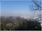
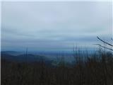
Šmarna gora is a 669 m peak northwest of Slovenia's capital. From the summit, with its restaurant and church, there is a beautiful view over Gore...
50 min |
 | Tacen - Šmarna gora (via Spodnja Kuhinja)
Šmarna gora is a 669 m peak northwest of Slovenia's capital. From the summit, with its restaurant and church, there is a beautiful view over Gore...
55 min |
 | Povodje - Šmarna gora
Šmarna gora is a 669 m peak northwest of Slovenia's capital. From the summit, with its restaurant and church, there is a beautiful view over Gore...
1 h 30 min |
 | Šmartno - Šmarna gora (path around Šmarna gora)
Šmarna gora is a 669 m peak northwest of Slovenia's capital. From the summit, with its restaurant and church, there is a beautiful view over Gore...
1 h 30 min |
 | Vikrče - Šmarna gora (via Zatrep)
Šmarna gora is a 669 m peak northwest of Slovenia's capital. From the summit, with its restaurant and church, there is a beautiful view over Gore...
1 h 10 min |
 | Tacen - Šmarna gora (Partizanska steza)
Šmarna gora is a 669 m peak northwest of Slovenia's capital. From the summit, with its restaurant and church, there is a beautiful view over Gore...
1 h |
| Tacen (Sveti Jurij) - Šmarna gora (Romarska pot)
Šmarna gora is a 669 m peak northwest of Slovenia's capital. From the summit, with its restaurant and church, there is a beautiful view over Gore...
1 h |
| Tacen (Sveti Jurij) - Šmarna gora (Partizanska steza)
Šmarna gora is a 669 m peak northwest of Slovenia's capital. From the summit, with its restaurant and church, there is a beautiful view over Gore...
1 h |
 | Vikrče - Šmarna gora (Kovačeva steza)
Šmarna gora is a 669 m peak northwest of Slovenia's capital. From the summit, with its restaurant and church, there is a beautiful view over Gore...
1 h 10 min |
| Vikrče - Šmarna gora (learning trail)
Šmarna gora is a 669 m peak northwest of Slovenia's capital. From the summit, with its restaurant and church, there is a beautiful view over Gore...
1 h 20 min |
 | Gabrje - Sveti Jakob
The Church of St. James is located on a scenic hill north of the village of Topol pri Medvodah. From the summit, which features a registration bo...
1 h 30 min |
 | Povodje - Rašica (Vrh Staneta Kosca)
Vrh Staneta Kosca, better known as Rašica, is located north of Ljubljana, more precisely above the villages of Rašica and Dobeno. From the summit...
1 h 30 min |
 | Jablje Castle - Rašica (Vrh Staneta Kosca)
Vrh Staneta Kosca, better known as Rašica, is located north of Ljubljana, more precisely above the villages of Rašica and Dobeno. From the summit...
1 h 20 min |
| Loka - Rašica (Vrh Staneta Kosca)
Vrh Staneta Kosca, better known as Rašica, is located north of Ljubljana, more precisely above the villages of Rašica and Dobeno. From the summit...
1 h 20 min |
 | Gabrje - Jeterbenk
Jeterbenk is a 774-meter-high peak located between the Slavkov dom hut on Golo Brdo and Katarina (the village of Topol). From the summit, where t...
1 h 30 min |
 | Skalnica - Sveta Gora (by road)
Sveta Gora is known mainly among believers and locals. It is a well-known pilgrimage center above Nova Gorica. Believers come here from all over ...
1 h |
 | Skalnica - Sveta Gora (footpath)
Sveta Gora is known mainly among believers and locals. It is a well-known pilgrimage center above Nova Gorica. Believers come here from all over ...
55 min |
 | Grgar - Sveta Gora (via Frančiškov hrib)
Sveta Gora is known mainly among believers and locals. It is a well-known pilgrimage center above Nova Gorica. Believers come here from all over ...
1 h 25 min |
 | Grgar - Sveta Gora (via Po sredi)
Sveta Gora is known mainly among believers and locals. It is a well-known pilgrimage center above Nova Gorica. Believers come here from all over ...
1 h 15 min |
| Grgar - Sveta Gora (via Ranjeke)
Sveta Gora is known mainly among believers and locals. It is a well-known pilgrimage center above Nova Gorica. Believers come here from all over ...
1 h 30 min |
 | Grgar - Sveta Gora (via Križce)
Sveta Gora is known mainly among believers and locals. It is a well-known pilgrimage center above Nova Gorica. Believers come here from all over ...
1 h 30 min |
 | Šmartno - Grmada
Grmada is a 676-meter-high mountain located west of the much more visited Šmarna gora. From the summit, which has a small takeoff area, a beautif...
55 min |
| Tacen - Grmada (via Spodnja Kuhinja)
Grmada is a 676-meter-high mountain located west of the much more visited Šmarna gora. From the summit, which has a small takeoff area, a beautif...
1 h |
 | Vikrče - Grmada (via Zatrep)
Grmada is a 676-meter-high mountain located west of the much more visited Šmarna gora. From the summit, which has a small takeoff area, a beautif...
1 h 15 min |
 | Vikrče - Grmada (Mazijeva steza)
Grmada is a 676-meter-high mountain located west of the much more visited Šmarna gora. From the summit, which has a small takeoff area, a beautif...
1 h 5 min |
| Tacen - Grmada (Mazijeva steza)
Grmada is a 676-meter-high mountain located west of the much more visited Šmarna gora. From the summit, which has a small takeoff area, a beautif...
1 h 10 min |
| Tacen (Sveti Jurij) - Grmada
Grmada is a 676-meter-high mountain located west of the much more visited Šmarna gora. From the summit, which has a small takeoff area, a beautif...
1 h 5 min |
 | Vikrče - Grmada (Kovačeva steza)
Grmada is a 676-meter-high mountain located west of the much more visited Šmarna gora. From the summit, which has a small takeoff area, a beautif...
1 h 10 min |
| Vikrče - Grmada (on Kovačeva steza and over Sedlo)
Grmada is a 676-meter-high mountain located west of the much more visited Šmarna gora. From the summit, which has a small takeoff area, a beautif...
1 h 15 min |
| Vikrče - Grmada (learning trail)
Grmada is a 676-meter-high mountain located west of the much more visited Šmarna gora. From the summit, which has a small takeoff area, a beautif...
1 h 20 min |
 | Za koridorjem - Sabotin (direct way)
Sabotin is a hill above Nova Gorica or, more precisely, above Solkan. Despite its modest height, it is an excellent viewpoint with views of the J...
1 h |
 | Za koridorjem - Sabotin (on ridge)
Sabotin is a hill above Nova Gorica or, more precisely, above Solkan. Despite its modest height, it is an excellent viewpoint with views of the J...
1 h 15 min |
 | Blatni dol - Koča na Planini nad Vrhniko
Planina nad Vrhniko is for Vrhnika locals something like Šmarna gora for those from Ljubljana. It is 733 m high, reachable by several paths from ...
1 h 10 min |
 | Vrhnika - Koča na Planini nad Vrhniko (via bukev)
Planina nad Vrhniko is for Vrhnika locals something like Šmarna gora for those from Ljubljana. It is 733 m high, reachable by several paths from ...
1 h 5 min |
 | Vrhnika - Koča na Planini nad Vrhniko (via Špica)
Planina nad Vrhniko is for Vrhnika locals something like Šmarna gora for those from Ljubljana. It is 733 m high, reachable by several paths from ...
1 h |
 | Stara Vrhnika - Koča na Planini nad Vrhniko (via Kuren)
Planina nad Vrhniko is for Vrhnika locals something like Šmarna gora for those from Ljubljana. It is 733 m high, reachable by several paths from ...
1 h 15 min |
| Stara Vrhnika - Koča na Planini nad Vrhniko (via Špica)
Planina nad Vrhniko is for Vrhnika locals something like Šmarna gora for those from Ljubljana. It is 733 m high, reachable by several paths from ...
1 h 15 min |
 | Senožeti - Sveti Miklavž above Sava (footpath)
The Church of St. Miklavž is situated on a panoramic hill south of Moravče. From the summit, there is a beautiful view toward the nearby Limbarsk...
1 h 20 min |
 | Hrastnik - Dom v Gorah
The Dom v Gorah mountain hut is located east of Hrastnik, just a few meters below the 786 m high peak where the church of St. Jurij stands. From ...
1 h 30 min |
 | Kekec - Škabrijel
Škabrijel is a hill northeast of the town of Gorica. Since the vegetation on the summit was cleared and a tall metal observation tower was erecte...
50 min |
 | Prevala - Škabrijel (via Veliki hrib)
Škabrijel is a hill northeast of the town of Gorica. Since the vegetation on the summit was cleared and a tall metal observation tower was erecte...
1 h 5 min |
| Prevala - Škabrijel
Škabrijel is a hill northeast of the town of Gorica. Since the vegetation on the summit was cleared and a tall metal observation tower was erecte...
50 min |
| Prevala - Škabrijel (via Hungarian pyramid)
Škabrijel is a hill northeast of the town of Gorica. Since the vegetation on the summit was cleared and a tall metal observation tower was erecte...
1 h |
 | Rečica ob Paki - Gora Oljka
Gora Oljka is a hill located east of Šmartno ob Paki. On the summit stands the Church of the Holy Cross, built in the mid-18th century. Just a fe...
1 h 15 min |
 | Podgora - Gora Oljka (Martin way)
Gora Oljka is a hill located east of Šmartno ob Paki. On the summit stands the Church of the Holy Cross, built in the mid-18th century. Just a fe...
1 h 20 min |
 | Zabukovica - Kotečnik
Kotečnik is a peak in the Posavsko hribovje, located north of Šmohor. It is a summit with two logboxes: the first on the western subpeak, offerin...
1 h 30 min |
 | Griže - Dragov dom na Homu (direct path)
Dragov dom is located on a scenic hill south of Šempeter. From the summit, where there is also the Church of St. Magdalena, there is a fine panor...
1 h 30 min |
| Šešče pri Preboldu - Dragov dom na Homu (via Lajnarjev hrib)
Dragov dom is located on a scenic hill south of Šempeter. From the summit, where there is also the Church of St. Magdalena, there is a fine panor...
1 h |
| Šešče pri Preboldu - Dragov dom na Homu (Brdovska pot)
Dragov dom is located on a scenic hill south of Šempeter. From the summit, where there is also the Church of St. Magdalena, there is a fine panor...
1 h 15 min |
 | Liboje - Dom na Šmohorju (via organic farm Kralj)
The mountain lodge on Šmohor is located on a picturesque and scenic ridge between Laško, Liboje and Zabukovica. The lodge, a popular spot for bot...
1 h 30 min |
 | Grgar - Vodice (via Ranjeke)
Vodice (according to some records also Sveti Jakob) is a peak on the western part of the Banjška planota plateau. From the summit, which features...
1 h 30 min |
 | Tremerje - Veliki Slomnik
Veliki Slomnik is a peak located between Košnica pri Celju and Liboje. The summit has a logbook box, but due to the surrounding forest, there are...
1 h |
 | Šentjur - Resevna
Resevna is a peak situated south of Šentjur. At the summit stands a 20-meter-high observation tower offering beautiful views that extend far acro...
1 h 30 min |
| Jakob pri Šentjurju - Resevna
Resevna is a peak situated south of Šentjur. At the summit stands a 20-meter-high observation tower offering beautiful views that extend far acro...
1 h 30 min |
 | Šentjur (center) - Resevna (steep path)
Resevna is a peak situated south of Šentjur. At the summit stands a 20-meter-high observation tower offering beautiful views that extend far acro...
1 h 30 min |
 | Gorica pri Slivnici - Rifnik
Rifnik is a 568-meter-high peak situated south of Šentjur pri Celju. The summit, known for its archaeological site, offers nice views towards Šen...
1 h 15 min |
 | Zagrad - Grmada above Celje (gentle path)
What Šmarna gora is to people from Ljubljana, Grmada is to those from Celje. Celje's local mountain lies south of the town above Zagrad village. ...
1 h 30 min |
 | Štore - Srebotnik
Srebotnik is a slightly vegetated peak located south of Celje and Štore in the Posavsko hribovje. The summit, which has a logbook box and a small...
1 h 30 min |
 | Zvodno - Srebotnik (on Celje mountain trail)
Srebotnik is a slightly vegetated peak located south of Celje and Štore in the Posavsko hribovje. The summit, which has a logbook box and a small...
1 h 15 min |
 | Lopata - Planinski dom Šentjungert
The mountain hut is located just a few meters below the summit of Gora, where the Church of St. Kunigunda stands; it was built in the 14th centur...
1 h 30 min |
 | Pišece (Pri mlinu) - Veliki Špiček
Veliki Špiček is the highest peak of Brežice municipality. From the top a nice view spreads towards the south and east. Most of Brežice municipal...
1 h 25 min |
 | Gabrje - Rog
Rog is an 798-meter peak above the village of Topol, just 10 minutes from St. Katarina's Church. From the summit, where a large cross once stood,...
1 h 20 min |
 | Bresternica (Šoberjev dvor) - Tojzlov vrh
Tojzlov vrh is a forested hill on the eastern part of Kozjak. On the summit stands a small stone NOB monument and, more recently, also a summit l...
1 h 15 min |
 | Kamnica - Murovica
Murovica is a popular excursion point, accessible from the Posavje side, Domžale, or the Moravška Valley. On the summit there is a bench and a lo...
1 h 20 min |
 | Spodnja Rečica - Tolsto
Tolsto is a 780-meter-high hill between Huda Jama and Šmohor. The summit has a logbook and stamp box, but offers no view due to the forest....
1 h 15 min |
 | Reka - Rodne
Rodne is a 698-meter-high peak situated west of Orehovška Grapa. From the grassy summit, a nice view opens up towards the Cerkljansko-Idrijsko hi...
1 h 20 min |
 | Seljanec - Ham (via Seljanečki potok)
Ham is an isolated peak beside the Ivanščica range, above the Bednja river valley. It is separated from Ivanščica by the Železnice stream valley,...
1 h 30 min |
 | Grgar - Frančiškov hrib
Frančiškov hrib is a less prominent peak on Skalnica, whose highest point is the 681-meter-high Sveta Gora. From the panoramic summit, which feat...
1 h 15 min |
 | Trebnje Castle - Trebni vrh (via caves)
Trebni vrh is a 581-meter-high hill located south or southwest of Trebnje. On the forested summit stands a bench, and nearby is a logbook box wit...
50 min |
 | Trebnje Castle - Trebni vrh (steep path via hunting cottage)
Trebni vrh is a 581-meter-high hill located south or southwest of Trebnje. On the forested summit stands a bench, and nearby is a logbook box wit...
55 min |
| Trebnje Castle - Trebni vrh (via caves and hunting lodge)
Trebni vrh is a 581-meter-high hill located south or southwest of Trebnje. On the forested summit stands a bench, and nearby is a logbook box wit...
1 h |
 | Zagorica pri Dobrniču - Lisec (Liška gora)
Lisec is a 565-meter-high peak located north to northeast of Žužemberk and southwest of Dobrnič. On the summit stands a metal cross with an attac...
1 h |
 | Lesično - Brest (Bohor)
Brest is a peak on Bohor, though it resembles more of a saddle. It is an important trail junction on Bohor, lying between more easterly Oslica an...
1 h 30 min |
 | Kozje - Raskože (Bohor) (via Vetrnik)
Raskože is a 650-meter-high peak on the eastern part of Bohor. Some people also call this area Vetrnik. The south side of the peak is dominated b...
1 h 15 min |
 | Kozje - Pokojni vrh (Bohor) (via Vetrnik)
Pokojni vrh is on the eastern part of Bohor. The western part features a pasture, the rest mostly forest. There is no summit logbook. From the to...
1 h 30 min |
 | Loka pri Žusmu (Žamerk) - Žusem
Žusem is a 669-meter-high hill with a rich history and great potential for the future. It forms the northern edge of Kozjansko, and its name deri...
1 h 20 min |
 | Loka pri Žusmu (Žamerk) - Žusem (via Dobrina)
Žusem is a 669-meter-high hill with a rich history and great potential for the future. It forms the northern edge of Kozjansko, and its name deri...
1 h 30 min |
 | Bridge over Dušica - Bajturn (Zaplaški hrib) (on ridge)
Bajturn, or Zaplaški hrib, at 609 meters, is the highest peak in the Trebnje municipality. The summit features a pleasant bench with a table, a b...
1 h 20 min |
| Bridge over Dušica - Bajturn (Zaplaški hrib) (on north slope)
Bajturn, or Zaplaški hrib, at 609 meters, is the highest peak in the Trebnje municipality. The summit features a pleasant bench with a table, a b...
1 h 30 min |
| Okrog (Lazar) - Bajturn (Zaplaški hrib) (on ridge)
Bajturn, or Zaplaški hrib, at 609 meters, is the highest peak in the Trebnje municipality. The summit features a pleasant bench with a table, a b...
1 h 30 min |
 | Bad Gleichenberg (Sägewerk Weiss) - Stradner Kogel
Stradner Kogel is the highest hill in southeastern Styria, Austria. The hill is of volcanic origin, and the summit offers no views in any directi...
1 h 15 min |
| Haag - Stradner Kogel
Stradner Kogel is the highest hill in southeastern Styria, Austria. The hill is of volcanic origin, and the summit offers no views in any directi...
1 h 10 min |
 | Gradišče pri Vipavi - Škavnica
Škavnica is a 734-meter-high peak above Vipava. From the summit, which features a small cross and bench, there are excellent views of the Vipava ...
1 h 15 min |
 | Socka - Kozjek (above Socka)
Kozjek (above Socka) is an interesting peak located west of the ridged Kislica, like a sharpened extension of it with precipitous walls on its we...
1 h 10 min |
 | Stogovci (Vabča vas) - Kerješetov vrh
Kerješetov vrh is a 590-meter-high hill located above the settlement of Jelovice. The summit is overgrown with forest, so there is no good view f...
1 h 30 min |
 | Center Vintgar - Lookout point at Ančnikovo gradišče (via Bistriški vintgar)
The lookout platform is located near Ančnikovo gradišče. It offers a nice view. You can see the settlement of Slovenska Bistrica and its surroun...
1 h 30 min |
 | Radoboj - Sekolje (Strahinjčica)
Sekolje is the easternmost peak of Strahinjčica. It appears as an interesting cone shape from the surrounding areas. The view from the peak is li...
1 h 30 min |
 | Hetinj / Hosszúhetény - Zengő (Mecsek) (pot rumeni trikotnik)
Zengő is the highest peak of the Mecsek Mountains, located in southern Hungary. A large observation tower stands at the summit, offering exceptio...
1 h |
 | Rimske Toplice - Stražnik (via Borovo)
Stražnik is a 648-meter peak south of Rimske Toplice. The summit features a bench and summit register box, with a cross erected in 2021 about 50 ...
1 h 20 min |
 | Podčetrtek (Terme Olimia) - Zavetišče Šmarnica on Mala Rudnica (past castle Podčetrtek)
The Šmarnica shrine is located on Mala Rudnica within the Rudnica range, a smaller hill chain above Podčetrtek. From the shrine there opens a bea...
1 h 15 min |
| Podčetrtek (sveti Lovrenc) - Zavetišče Šmarnica on Mala Rudnica (past castle Podčetrtek)
The Šmarnica shrine is located on Mala Rudnica within the Rudnica range, a smaller hill chain above Podčetrtek. From the shrine there opens a bea...
1 h 5 min |
| Podčetrtek (sveti Lovrenc) - Zavetišče Šmarnica on Mala Rudnica
The Šmarnica shrine is located on Mala Rudnica within the Rudnica range, a smaller hill chain above Podčetrtek. From the shrine there opens a bea...
1 h |
 | Podčetrtek (sveti Lovrenc) - Silavec (The Tower of Health and Joy on Rudnica) (past castle Podčetrtek)
Silavec is a 622-meter-high peak on Rudnica above Podčetrtek, on which stands a lookout tower slightly over 35 meters tall, offering a beautiful ...
1 h 25 min |
| Podčetrtek (sveti Lovrenc) - Silavec (The Tower of Health and Joy on Rudnica) (easier path)
Silavec is a 622-meter-high peak on Rudnica above Podčetrtek, on which stands a lookout tower slightly over 35 meters tall, offering a beautiful ...
1 h 15 min |
| Podčetrtek (sveti Lovrenc) - Silavec (The Tower of Health and Joy on Rudnica) (harder path)
Silavec is a 622-meter-high peak on Rudnica above Podčetrtek, on which stands a lookout tower slightly over 35 meters tall, offering a beautiful ...
1 h 15 min |
| Spodnje Tinsko - Silavec (The Tower of Health and Joy on Rudnica)
Silavec is a 622-meter-high peak on Rudnica above Podčetrtek, on which stands a lookout tower slightly over 35 meters tall, offering a beautiful ...
1 h 20 min |
| Slake (Church of the Virgin Mary on Pesek) - Silavec (The Tower of Health and Joy on Rudnica) (harder path)
Silavec is a 622-meter-high peak on Rudnica above Podčetrtek, on which stands a lookout tower slightly over 35 meters tall, offering a beautiful ...
1 h 25 min |
| Slake (Church of the Virgin Mary on Pesek) - Silavec (The Tower of Health and Joy on Rudnica) (easier path)
Silavec is a 622-meter-high peak on Rudnica above Podčetrtek, on which stands a lookout tower slightly over 35 meters tall, offering a beautiful ...
1 h 25 min |
 | Zgornje Poljčane - Rančka
Rančka is a 615-meter-high peak located west to southwest of Boč. Just below the summit is a stamp box with a bench nearby; the highest point its...
1 h 25 min |
| Zgornje Poljčane - Rančka (po Jakobovi poti)
Rančka is a 615-meter-high peak located west to southwest of Boč. Just below the summit is a stamp box with a bench nearby; the highest point its...
1 h 25 min |
 | Olimje - Plešivec (Rudnica)
Plešivec is a forest-covered peak on Rudnica, its highest point. The summit has a summit register box, a bench, and a table....
1 h 30 min |
 | Kozje - Vetrnik
Vetrnik is a 709 m panoramic peak in Kozjanski Park above Kozje on the eastern edge of Bohor. Besides the summit logbook and stamp, it also featu...
1 h |
 | Prebold - Žvajga (northern peak) (eastern path)
The northern peak of Žvajga is a 620-meter-high hill located south to southwest of Prebold and northwest of the slightly higher southern peak. A ...
50 min |
 | Prebold - Žvajga (northern peak) (western path)
The northern peak of Žvajga is a 620-meter-high hill located south to southwest of Prebold and northwest of the slightly higher southern peak. A ...
1 h 5 min |
 | Prebold - Tolsti vrh (above Prebold)
Tolsti vrh is a 756-meter-high mountain located southwest of Prebold. From the summit, where a logbook is located, there are partial views toward...
1 h 25 min |
 | Rukavac - Orjak (above Opatija) (direct way)
Orjak is a 722-meter-high peak above Opatija. The rocky summit features two stamps and a logbook. From the top, there are views of Opatija and pa...
1 h 30 min |
 | Liganj - Lužinski breg
Lužinski breg is a panoramic peak above Lovran on Učka. From the summit, where there is a bench with a table and a logbook, the highest peak of U...
1 h |
 | Liganj - Gorica (above Lovran)
Gorica is a panoramic peak above Lovran, which is on Učka. The summit has a logbook. From the top, parts of Učka are visible, highlighted by its ...
1 h 10 min |
 | Stojdraga (Glažuta) - Tuščak (Žumberačka gora)
Tuščak is a forested hill above the Bregana River valley on Žumberačka gora. The summit features a logbox....
1 h 10 min |
 | Stojdraga (Glažuta) - Gradina Tuščak (via Tuščak)
Gradina Tuščak is an HPO point about 10 minutes off the Tuščak summit. The castle is believed to have been built at the end of the 12th or beginn...
1 h 20 min |
 | Podsreda - Rigelj
Rigelj is a 626-meter-high indistinct peak in the Orlice range, on which a few antennas stand....
1 h 15 min |
 | Pišece (Pri mlinu) - Velika Vagla
Velika Vagla is a 667-meter-high peak located in the Orlice mountain range, specifically along the marked trail from Pišece to Veliki Špiček....
1 h 5 min |
 | Pišece (Pri mlinu) - Veliki vrh (nad Pišecami)
Veliki vrh is a forested peak located between Veliki Špiček and Velika Vagla. A marked trail from Pišec to Veliki Špiček passes over the summit, ...
1 h 15 min |
 | Stari trg (Pilštanj) - Bredič
Bredič is a 692-meter-high peak in the ridge of the same name, which rises steeply above the right bank of the Bistrica River between the settlem...
1 h 25 min |