 | Gozd - Tolsti vrh (Sheep Trail across Kriška Gora)
Tolsti vrh, located west of Storžič, is at 1715 metres also the highest peak of the Kriška gora range, which rises steeply above central Gorenjsk...
2 h 30 min |
 | Tominčev slap Waterfall - Dobrča
Dobrča is a 1634-metre mountain located between Begunje and Tržič. From the summit, which has a registration box with a stamp, the view opens onl...
3 h |
 | Draga - Dobrča (via Ledena trata)
Dobrča is a 1634-metre mountain located between Begunje and Tržič. From the summit, which has a registration box with a stamp, the view opens onl...
3 h |
 | Hudi Graben - Dobrča (via Lešanska planina)
Dobrča is a 1634-metre mountain located between Begunje and Tržič. From the summit, which has a registration box with a stamp, the view opens onl...
2 h 35 min |
| Hudi Graben - Dobrča
Dobrča is a 1634-metre mountain located between Begunje and Tržič. From the summit, which has a registration box with a stamp, the view opens onl...
2 h 30 min |
 | Grahovše - Veliki Javornik (Ženiklovec)
Veliki Javornik (also known as Ženiklovec) is a 1716 m high peak located between Storžič and Stegovnik. From the grassy summit with its registrat...
2 h 45 min |
 | Tržiški graben - Veliki Javornik (Ženiklovec)
Veliki Javornik (also known as Ženiklovec) is a 1716 m high peak located between Storžič and Stegovnik. From the grassy summit with its registrat...
2 h 30 min |
| Grahovše - Veliki Javornik (Ženiklovec) (via Rekar)
Veliki Javornik (also known as Ženiklovec) is a 1716 m high peak located between Storžič and Stegovnik. From the grassy summit with its registrat...
2 h 45 min |
 | Leskovica - Blegoš (on unmarked path)
Blegoš is a 1,562-metre-high mountain located between the Selška Sora and Poljanska Sora rivers. From the grassy summit, where there is a stamp a...
2 h 5 min |
| Volaka - Blegoš (on unmarked path)
Blegoš is a 1,562-metre-high mountain located between the Selška Sora and Poljanska Sora rivers. From the grassy summit, where there is a stamp a...
2 h 35 min |
 | Smrečje - Pečovnik (survey point 1668) (by road)
Pečovnik (1668 m) is a 1668-meter-high mountain located between Plešivec (1801 m) and Virnikov Grintovec (1654 m). From its grassy summit on the ...
2 h 45 min |
 | Rateče - Ofen/Peč (western path, past bivouac and on footpath)
Peč (also known as Tromeja; in Italian Monte Forno, in German Dreiländereck or Ofen) is a 1508 m high peak located at the tripoint between Sloven...
2 h 15 min |
| Rateče - Ofen/Peč (western path, past bivouac and on mule track)
Peč (also known as Tromeja; in Italian Monte Forno, in German Dreiländereck or Ofen) is a 1508 m high peak located at the tripoint between Sloven...
2 h 20 min |
 | Dom Pristava in Javorniški Rovt - Ptičji vrh
Ptičji vrh is a 1550-meter-high mountain located in the main ridge of the Karavanke, between Struška and Golica. From the summit, through which t...
1 h 45 min |
 | Klemenčevo - Kamniški vrh (by Korošaki waterfalls)
Kamniški vrh is a 1259-metre-high mountain located north of Kamnik, more precisely between Stahovica and the Korošica valley. From the summit, wh...
2 h 15 min |
 | Klemenčevo - Kamniški vrh (on southwest slope)
Kamniški vrh is a 1259-metre-high mountain located north of Kamnik, more precisely between Stahovica and the Korošica valley. From the summit, wh...
1 h 45 min |
 | Planina pod Golico - Klek (via Rožca)
Klek is a 1753-metre-high mountain located between Hruški vrh and the better-known Golica. The summit, on the border between Slovenia and Austria...
2 h 20 min |
 | Planina pod Golico - Klek (via Ovčarska koča)
Klek is a 1753-metre-high mountain located between Hruški vrh and the better-known Golica. The summit, on the border between Slovenia and Austria...
3 h |
 | Log - Vošca
Vošca is a 1737 m high peak located west of Trupejevo poldne. From the grassy summit, there is a beautiful view of the Julian Alps, western Karaw...
2 h 30 min |
| Srednji vrh - Vošca
Vošca is a 1737 m high peak located west of Trupejevo poldne. From the grassy summit, there is a beautiful view of the Julian Alps, western Karaw...
2 h |
 | Srednji Vrh - Vošca (via Zajčnik)
Vošca is a 1737 m high peak located west of Trupejevo poldne. From the grassy summit, there is a beautiful view of the Julian Alps, western Karaw...
2 h 35 min |
| Srednji Vrh - Vošca (via Jureževa planina)
Vošca is a 1737 m high peak located west of Trupejevo poldne. From the grassy summit, there is a beautiful view of the Julian Alps, western Karaw...
2 h 5 min |
 | Srnjak - Vošca
Vošca is a 1737 m high peak located west of Trupejevo poldne. From the grassy summit, there is a beautiful view of the Julian Alps, western Karaw...
2 h 45 min |
 | Razdrto - Vojkova koča na Nanosu (Janez's path)
Vojkova koča is located on the southern edge of the high karst Nanos plateau, near Pleša. This is the prominent peak with television transmitters...
2 h |
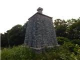
 | Source of Ljubija - Smrekovec (via Leskovškova pustota)
Smrekovec is a mountain of volcanic origin on the eastern edge of the Smrekovec mountain range. The wide grassy summit features a pyramid with a ...
2 h 20 min |
| Source of Ljubija - Smrekovec (by road)
Smrekovec is a mountain of volcanic origin on the eastern edge of the Smrekovec mountain range. The wide grassy summit features a pyramid with a ...
2 h 30 min |
 | Valley of stream Žep - Komen
At 1684 meters, Komen is the highest peak in the Smrekovec mountain range, which borders between Styria and Carinthia. In good weather, the summi...
2 h 30 min |
 | Valley of stream Žep - Veliki Travnik (Turnovka) (via partisan hospital)
Veliki Travnik, also known as Turnovka by the locals, is located on the western edge of the Smrekovec mountain range. From the summit, which has ...
2 h 25 min |
 | Mislinjski graben (Pestotnik) - Rogla (via Ostruščica)
Rogla is a peak in the middle of the eponymous ski resort. The peak is forested with a small clearing on which stands a lookout tower. The tower ...
3 h |
 | Smrečje - Pečovnik (by road)
Pečovnik is a 1640-meter-high peak situated in the ridge of mountains between Košuta and Virnikov Grintovec. From the partly vegetated peak, a ni...
2 h 35 min |
 | Nemci - Mrzovec
Mržovec is the most prominent peak in the heart of the Trnovo Plateau. Its location offers wonderful views, though high trees obscure them from t...
2 h 40 min |
 | Jevšček - Monte Mataiur/Matajur
Matajur is a panoramic mountain located on the border between Slovenia and Italy. From the summit there is a beautiful view of Kobariški or Bregi...
2 h 30 min |
 | Poljšica pri Gorjah (Zatrata) - Galetovec (on footpath)
Galetovec is an indistinct peak on the southeastern part of the Pokljuka plateau. From the summit, which has a logbook, there is a nice view of t...
2 h 35 min |
 | Draga - Šentanski vrh (via Ledena trata)
Šentanski vrh, located in the Dobrča range just five minutes from the main peak, offers a nice view of the central Karawanks, the Storžič group, ...
3 h 5 min |
 | Hudi Graben - Šentanski vrh (via Lešanska planina)
Šentanski vrh, located in the Dobrča range just five minutes from the main peak, offers a nice view of the central Karawanks, the Storžič group, ...
2 h 40 min |
| Hudi Graben - Šentanski vrh
Šentanski vrh, located in the Dobrča range just five minutes from the main peak, offers a nice view of the central Karawanks, the Storžič group, ...
2 h 35 min |
 | NC Planica - Glave (by ski jumping hill)
Glave is an indistinct side ridge of Ponca, rising steeply west of Planica. Maps incorrectly label its highest peak (1,760 m) as Ovčja stran; tha...
2 h 30 min |
| Rateče (Ledine) - Glave
Glave is an indistinct side ridge of Ponca, rising steeply west of Planica. Maps incorrectly label its highest peak (1,760 m) as Ovčja stran; tha...
2 h 50 min |
 | Podbreg - Logarska peč
Logarska peč is a peak or viewpoint a few meters below the summit, rising steeply above the Logarska Valley. From Logarska peč there is a very ni...
2 h 20 min |
 | Grant - Jehlc (Špičasta kupa)
Different maps list various names for Jehlc, which also vary in elevation. Locals call the peak Jehlc (1625 m), while newer maps show Jehelc and ...
2 h 45 min |
 | Bukovo - Kojca (north path)
Kojca is a panoramic peak rising south of Baška grapa. From the summit, where there is a haystack, fine views extend over the Lower Bohinj Mounta...
2 h 15 min |
 | Bukovo - Kojca (south path)
Kojca is a panoramic peak rising south of Baška grapa. From the summit, where there is a haystack, fine views extend over the Lower Bohinj Mounta...
2 h 15 min |
 | Jesenice (Ukova) - Španov vrh
Španov vrh is a 1334-meter-high mountain in the Karavanke that rises between Javorniški Rovt and Planina pod Golico. From the scenic summit, acce...
2 h |
 | Jesenice (Straža) - Španov vrh (via Jelenkamen)
Španov vrh is a 1334-meter-high mountain in the Karavanke that rises between Javorniški Rovt and Planina pod Golico. From the scenic summit, acce...
2 h 30 min |
 | Zalog - Grebenc
Grebenc is a lesser-known peak that rises steeply above Mala and Velika Poljana. From this little-visited summit, on a clear day there is a nice ...
2 h 25 min |
 | Povlje - Grebenc
Grebenc is a lesser-known peak that rises steeply above Mala and Velika Poljana. From this little-visited summit, on a clear day there is a nice ...
2 h 5 min |
| Povlje - Grebenc (by cart track)
Grebenc is a lesser-known peak that rises steeply above Mala and Velika Poljana. From this little-visited summit, on a clear day there is a nice ...
2 h 5 min |
 | Valley of stream Žep - Mali Travnik
Mali Travnik is a lesser-known peak located south of the more famous Veliki Travnik. From the partly vegetated summit, there is a nice view of th...
2 h 5 min |
 | 2nd hairpin turn of Vršič road - Visoki Mavrinc (Za Kumlehom)
Visoki Mavrinc (Špica v Sedelcih) is a 1562 m high mountain between Suha, Mala, and Velika Pišnica. From the summit, where a wooden cross and ple...
2 h |
 | Spodnje Danje - Altemaver (Ratitovec)
Altemaver (Ratitovec), at 1,678 meters, is the highest peak of Ratitovec. From its grassy summit, there is a beautiful view of the Julian Alps, J...
2 h 30 min |
 | Razdrto - Grmada (Nanos)
Grmada is a 1209-meter peak situated near the edge of the Nanos plateau, northwest of the better-known Pleša (about a 20-minute walk away). Becau...
2 h 5 min |
 | Dom Pristava in Javorniški Rovt - Mala Golica
Mala Golica is a less distinct peak located east of Krvavka. From its grassy summit, there is a nice view of the Dravska dolina, Struško, parts o...
2 h 5 min |
 | Srednji Vrh - Zajčnik
Zajčnik (also Blekova) is a 1746-meter-high peak situated northeast of Vošca. From the partly vegetated summit, which borders Slovenia and Austri...
2 h 10 min |
 | Makekova Kočna - Visoki vrh above Jezersko (via Javornik)
Visoki vrh is a 1459-meter-high mountain in the ridge between Makekovo Kočna and Ravenska Kočna. From the summit, there is a fine view toward Koč...
2 h 15 min |
 | Kal - Rušni vrh
Rušni vrh is a 1,786-meter-high peak located east of Črna Prst. From the summit, which features a border stone from the old Rapallo border, a bea...
2 h 20 min |
 | Spodnje Danje - Kremant (Ratitovec)
Kremant is a 1,654 m high peak located on the western part of Ratitovec. From the summit, where a stamp is attached to a metal pole, a nice view ...
2 h 30 min |
 | Srnjak - Grpišca
Grpišca is a 1,676 m high grassy peak located in the main ridge of the Karavanke, more precisely between Kamnati vrh and Vošca. From the summit, ...
2 h |
 | Srnjak - Tamarča
Tamarča is a lesser-known peak located northwest of Vošca. From its summit, surrounded by larch forest, a nice view opens up onto the Martuljek m...
2 h 30 min |
 | Rateče - Monte Coppa
Kopa (Kopje on some maps), or Monte Coppa in Italian, is a 1496-meter-high peak on the Italian side of the Karawanks. The old Rapallo border once...
2 h |
 | Radovna - Vošni vrh
Vošni vrh is a 1,621-meter-high mountain located in the ridge that begins at Radovna and ends at Tosc. Although the summit itself is in the fores...
3 h |
 | Sele pri Cerkvi / Zell - Pfarre - Mejnik
Mejnik is a 1517-meter-high peak on the Austrian side of the Karawanks, more precisely in a side ridge of Košuta. On the forested summit is a bou...
1 h 55 min |
| Ridovc / Ridovcsäge - Mejnik (via valley of Mrzli potok)
Mejnik is a 1517-meter-high peak on the Austrian side of the Karawanks, more precisely in a side ridge of Košuta. On the forested summit is a bou...
2 h 5 min |
 | Podkoren - Visoka Bavha
Visoka Bavha is a 1,650-meter-high peak located on the border ridge of the Karawanks. The view from the summit is better towards the Austrian sid...
2 h |
 | Podvolovljek (Petkov graben) - Kunšperski vrh (Brezovec)
Kunšperski vrh, also Brezovec, is a lesser-known peak located west of Lepenatka. From its partly vegetated summit, nice views open up towards Vel...
2 h |
 | Tolminske Ravne - Grušnica (via planina na Kalu)
Grušnica is a 1,570-meter-high peak located between Čadrg, the Tolminka valley, and Tolminske Ravne. From the summit, which drops steeply toward ...
1 h 45 min |
 | Mislinjski graben (Pestotnik) - Ostruščica
Ostruščica is a 1,498-meter-high peak located west of the ski slopes on Rogla....
2 h 30 min |
 | Podljubelj (Lajb) - Čisovec
Čisovec is a panoramic peak located between Dobrča and Begunjščica. From the summit, beautiful views open up towards Košuta, the Kamnik-Savinja A...
2 h |
 | Trbiž / Tarviso - Florjanka / Monte Florianca (on transport road)
Florjanka is a 1,653-meter-high mountain on the Italian side of the Julian Alps. At or just below the summit is a reservoir for snowmaking on the...
2 h 30 min |
 | Rebrca / Rechberg - Stara gora / Altberg (via Bukovnik)
Stara gora is a 1,552-meter-high peak located northeast of Ojstrca, the highest peak of Obir. On the summit stand a wooden cross and a bench, wit...
2 h 50 min |
 | Slovenji Plajberk / Windisch Bleiberg - Kosmatica / Kosmatitza
Kosmatica / Kosmatitza is a 1,659-meter-high peak entirely on the Austrian side of the Karawanks, north of Vrtača. From the summit, which is part...
3 h |
 | Bela Peč / Villa Bassa - Črni vrh / Colrotondo
Črni vrh / Colrotondo is a fairly panoramic peak located west to southwest of the Belopeška jezera lakes. From the summit, which features a hunti...
2 h |
 | Slovenji Plajberk / Windisch Bleiberg - Veliki Rob / Großer Rain (via Veronjak / Hausberg)
Veliki Rob / Großer Rain is a 1,464-meter-high peak located on the Austrian side of the Karawanks, specifically in the ridge above the Poden / Bo...
2 h 15 min |
 | Podljubelj - Robič (via Zavetišče na Kalu)
Robič is a 1,384-meter-high peak located between the Tržiška Bistrica Valley and the Košuta ridge. From the summit, there is a beautiful view mai...
2 h 15 min |
| Dolina - Robič
Robič is a 1,384-meter-high peak located between the Tržiška Bistrica Valley and the Košuta ridge. From the summit, there is a beautiful view mai...
1 h 55 min |
| Tržič (Čegelše) - Robič (via Zavetišče na Kalu)
Robič is a 1,384-meter-high peak located between the Tržiška Bistrica Valley and the Košuta ridge. From the summit, there is a beautiful view mai...
2 h 55 min |
| Podljubelj (Pod Košuto) - Robič (via lake Jezero pri Čežov)
Robič is a 1,384-meter-high peak located between the Tržiška Bistrica Valley and the Košuta ridge. From the summit, there is a beautiful view mai...
2 h 15 min |
 | Dovje - Bela peč (above Dovje)
Bela peč is a lesser-known peak located above the marked trail from Dovje to Dovška Baba. From the summit, there is a beautiful view to the south...
2 h |
| Dovje - Bela peč (above Dovje) (via Blažčeva skala)
Bela peč is a lesser-known peak located above the marked trail from Dovje to Dovška Baba. From the summit, there is a beautiful view to the south...
2 h 15 min |
 | Veliko Tinje - Veliki vrh (on Pohorje) (via Sveti Urh)
Veliki vrh is a 1344-meter-high peak located above the RTC Jakec - Trije kralji ski slope. The highest point of the peak is in the forest, but ju...
2 h 55 min |
 | Aflenz Kurort (Freibad Aflenz) - Schönleitenhaus (Windgrube) (on southern ridge)
The Schönleitenhaus hut is located just a few meters below the Windgrube summit. From the hut or the summit, there is a beautiful view of the sur...
3 h |
| Aflenz Kurort (Bürgergraben) - Schönleitenhaus (Windgrube) (on southern ridge)
The Schönleitenhaus hut is located just a few meters below the Windgrube summit. From the hut or the summit, there is a beautiful view of the sur...
3 h |