 | Mesnice - Krim (by road)
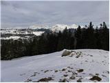
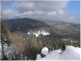
Krim is a 1,107-metre-high mountain rising south of the Ljubljana Marsh. From the summit, where a mountain hut and several transmitters stand, th...
1 h 50 min |
 | Polharski dom Krim - Krim
Krim is a 1,107-metre-high mountain rising south of the Ljubljana Marsh. From the summit, where a mountain hut and several transmitters stand, th...
1 h 35 min |
 | Bohinjsko sedlo - Možic (direct way)
Možic is a 1,602 m high peak located west of Soriška Planina. At the very summit there is an old military bunker bearing the name of the peak and...
1 h 15 min |
| Bohinjsko sedlo - Možic (by Lajnar)
Možic is a 1,602 m high peak located west of Soriška Planina. At the very summit there is an old military bunker bearing the name of the peak and...
1 h 30 min |
 | Vrh Bače - Možic
Možic is a 1,602 m high peak located west of Soriška Planina. At the very summit there is an old military bunker bearing the name of the peak and...
1 h |
 | Radlek - Slivnica
Slivnica is a 1,114-meter-high peak located north of the Cerknica Field and the intermittent Lake Cerknica. The summit itself is quite rounded, p...
1 h 20 min |
 | Volovljek - Kranjska reber
Kranjska reber, also known as Vrh Kašne planine (1435 m), is a mountain of volcanic origin. From the summit, which has a registration box with a ...
1 h 20 min |
 | End of road - Lepenatka
Lepenatka is a grassy peak located south of the 1557-metre-high Rogatec. From the summit, which has a summit register box and stamp, there is a b...
1 h |
 | Leška gmajna - Lepenatka
Lepenatka is a grassy peak located south of the 1557-metre-high Rogatec. From the summit, which has a summit register box and stamp, there is a b...
1 h 15 min |
 | Bohinjsko sedlo - Dravh (via Lajnar)
Dravh is a 1,547-metre-high peak situated between Sorica and Soriška Planina. From the unforested summit a beautiful view opens across the Škofja...
1 h |
 | Črni Kal - Koprivnik (via Romovec)
Koprivnik is a 1393-meter-high mountain located between Blegoš and Mladi vrh. From the summit, which has a registration box and a stamp, the view...
1 h |
 | Kramarica - Smrekovec (by road)
Smrekovec is a mountain of volcanic origin on the eastern edge of the Smrekovec mountain range. The wide grassy summit features a pyramid with a ...
1 h 30 min |
 | Krnica - Kucelj (on Čaven) (via Veliki Rob)
Kucelj is located on the southern slopes of the Trnovski Forest, northwest of the Vipava Valley. From the bare summit, where a cross stands, ther...
1 h 40 min |
 | Mala Lazna - Mali Golak
Mali Golak is the highest peak in the Golaki group at 1495 meters above sea level and at the same time the highest point of the entire Trnovski g...
1 h 25 min |
 | Kozarnice - Mali Golak
Mali Golak is the highest peak in the Golaki group at 1495 meters above sea level and at the same time the highest point of the entire Trnovski g...
1 h 5 min |
| Bevški vrh - Mali Golak
Mali Golak is the highest peak in the Golaki group at 1495 meters above sea level and at the same time the highest point of the entire Trnovski g...
1 h 35 min |
 | Škrbina - Srednji Golak
Srednji Golak is located between Mali and Veliki Golak on the plateau of Trnovski gozd above Predmeja. The peak is covered with dwarf pines, and ...
1 h 15 min |
 | Lokve - Poldanovec
Poldanovec is located in Govci, on the northern edge of the Trnovo plateau. Govci rise steeply above the valley of Gorenja Trebuša. Poldanovec is...
1 h 30 min |
 | Turški klanec - Mrzovec
Mržovec is the most prominent peak in the heart of the Trnovo Plateau. Its location offers wonderful views, though high trees obscure them from t...
1 h 30 min |
 | Podmeja - Mrzlica
In recent years, Mrzlica has become an extremely popular excursion spot, especially for visitors from Savinjska valley and Zasavje. At 1,122 mete...
1 h 15 min |
 | Podmeja - Mrzlica
In recent years, Mrzlica has become an extremely popular excursion spot, especially for visitors from Savinjska valley and Zasavje. At 1,122 mete...
1 h 15 min |
 | Vrh Bače - Krevl
Krevl is a 1515-meter-high peak situated south of the Kobla ski area, more precisely between the Kobla peak and Kravja Črna gora. From the summit...
1 h |
 | Prvine - Črni vrh (Čemšeniška planina)
Črni vrh is the highest peak of Čemšeniška planina and, at 1,204 m, the second-highest peak in Posavsko hribovje. The summit has a logbook box bu...
1 h |
 | Planinski dom Vrhe - Črni vrh (Čemšeniška planina)
Črni vrh is the highest peak of Čemšeniška planina and, at 1,204 m, the second-highest peak in Posavsko hribovje. The summit has a logbook box bu...
1 h 30 min |
 | Ljubelj - Polna peč
Polna peč (also marked as Ravna peč on maps) is situated above the Ljubelj tunnel. From the somewhat precipitous summit there is a nice view of t...
1 h 15 min |
 | Lome - Javornik (above Črni Vrh)
Javornik is a forested peak located southeast of Črni Vrh. In 1972, a wooden observation tower was built on it, rising above the treetops and off...
1 h 5 min |
| Črni Vrh (Grom) - Javornik (above Črni Vrh)
Javornik is a forested peak located southeast of Črni Vrh. In 1972, a wooden observation tower was built on it, rising above the treetops and off...
1 h 15 min |
 | Repna dolina - Javornik (above Črni Vrh)
Javornik is a forested peak located southeast of Črni Vrh. In 1972, a wooden observation tower was built on it, rising above the treetops and off...
1 h 45 min |
 | Vodice (Mali Školj) - Javornik (above Črni Vrh)
Javornik is a forested peak located southeast of Črni Vrh. In 1972, a wooden observation tower was built on it, rising above the treetops and off...
1 h 35 min |
 | Kalce - Veliki Javornik (Javorniki)
Veliki Javornik is a 1,268-meter-high peak of the forested hills named Javorniki. The extensive Javorniki forests stretch from Postojna to Cerkni...
1 h 30 min |
 | Mariborska koča - Žigartov vrh
Žigartov vrh, at 1,346 meters, is the highest peak in the eastern part of Pohorje. An "observation" tower once stood on the summit, erected solel...
1 h 40 min |
 | Mala Učka - Vojak
Vojak, at 1401 m, is the highest peak of Učka, a range rising steeply above the eastern Istrian coast. From the summit, which features a stone ob...
1 h 15 min |
 | Platak - Snježnik (via grlo)
Snježnik is a panoramic mountain in the western part of Gorski Kotar. From the summit there is a beautiful view of the Kvarner islands, Rijeka ba...
1 h 30 min |
| Platak - Snježnik (via crest)
Snježnik is a panoramic mountain in the western part of Gorski Kotar. From the summit there is a beautiful view of the Kvarner islands, Rijeka ba...
1 h 30 min |
 | Atelsko sedlo - Boskovec
Boskovec is with 1587 m the highest peak of the Golte plateau. From the top on which a lookout tower stands, a view opens up on part of Kamnik Sa...
1 h 30 min |
 | Zagrad - Razsušica (zahodna pot)
Razsušica, at 1083 meters, is the highest peak of Slovenian Istria. Although the summit is partly vegetated, it offers a nice view towards the ne...
1 h 15 min |
 | Cenc - Špičasti vrh (on marked path)
Špičasti vrh is a forest-covered mountain located south of the village of Zadlog. To ensure the summit is not without a view, a 13-meter-high woo...
1 h 30 min |
 | Podkraj - Križna gora (Hrušica) (steep way)
Križna gora is a 1162 m high peak located north of the village Podkraj. From the summit, where a lookout tower stands, there are fine views over ...
1 h |
| Podkraj - Križna gora (Hrušica) (gentle path)
Križna gora is a 1162 m high peak located north of the village Podkraj. From the summit, where a lookout tower stands, there are fine views over ...
1 h 20 min |
 | Podkraj - Sveti Duh (Hrušica)
The Church of the Holy Spirit is located just a few meters below the summit of Sveti Duh on the slopes of the forested Hrušica, in the range betw...
1 h 15 min |
 | Koča na planini Stador - Kobilja glava
Kobilja glava is a 1,475-meter-high peak located east of Tolmin. From the summit, where a cross stands, there is a beautiful view of Krn, the ran...
1 h 15 min |
 | Zgornji Goreljek - Javorov vrh (Pokljuka)
Javorov vrh is a 1,482 m high mountain amidst the vast forests of Pokljuka, specifically between the Konjska dolina and Jelje mountain pastures. ...
1 h 30 min |
 | Ravne - Cerk
Cerk, at 1,192 meters, is the highest peak of Borovška gora, a range situated between the Kolpa River valley and Goteniški Snežnik. From the summ...
1 h 30 min |
| Strma Reber - Cerk
Cerk, at 1,192 meters, is the highest peak of Borovška gora, a range situated between the Kolpa River valley and Goteniški Snežnik. From the summ...
1 h 45 min |
 | Kalce - Mali Javornik (Javorniki)
Mali Javornik is a 1219 m high mountain located in the forested ridge of Javorniki. There is no view from the summit itself due to the forest, bu...
1 h |
 | Solarji - Nagnoj
Nagnoj is the second-highest peak of the Kolovrat range at 1193 m. The range lies between Tolmin and Venetian Slovenia. From the summit, which ha...
1 h 40 min |
 | Soriška peč - Žbajnek
Žbajnek is a 1,538 m high peak located west of Ratitovec. From its grassy summit, surrounded by sparse forest, beautiful views open up of the Jul...
1 h 30 min |
 | Raspet - Kopa (Cimprovka)
Kopa is a 1360 m high peak or panoramic promontory from which a nice view opens up on Cerkno, the hills surrounding it, Ratitovec, Trnovski gozd,...
1 h 10 min |
 | Bohinjsko sedlo - Slatnik (southeastern peak) (via Lajnar)
Slatnik (southeastern peak) is a panoramic mountain that rises steeply above Baška grapa on one side and descends more gently toward Soriška plan...
1 h 5 min |
| Bohinjsko sedlo - Slatnik (southeastern peak) (past barracks)
Slatnik (southeastern peak) is a panoramic mountain that rises steeply above Baška grapa on one side and descends more gently toward Soriška plan...
1 h 10 min |
 | Dom na Paškem Kozjaku - Štrukljev vrh
Štrukljev vrh is, alongside Špik (1,108 m) and Basališče (1,272 m), one of the three main peaks of Paški Kozjak, a roughly 10 km long, narrow and...
1 h 30 min |
 | Dom na Paškem Kozjaku - Ostrica
Ostrica is an indistinct peak of Paški Kozjak, a 10-kilometer-long, quite narrow and steep limestone ridge between the gorges of the Paka and Hud...
1 h |
 | Čemernica / Tschemernitzen - Arihova peč / Arichwand
Arihova peč / Arichwand is a panoramic rocky cliff located near the Bleščeča planina / Rossalm pasture. A wooden hut stands on top of the cliff, ...
1 h 25 min |
 | St. John the Baptist on Ojstrica - Kozji vrh (at Košenjak)
Kozji vrh is a 1,383-meter-high peak located above Pernice; it is also the highest peak in the Municipality of Muta....
1 h 35 min |
 | Gornje Jelenje - Tuhobić (mountain path on Tuhobić)
Tuhobić is a 1109-meter-high peak from which beautiful views open in all directions, with the best sights of Risnjak, Snježnik, Veliki Snežnik, U...
1 h 50 min |
 | Chortata - Egklouvi road - Stavrota (Lefkada)
Stavrota is the highest peak at 1,182 m on the Greek island of Lefkada (also known as Lefkas), which lies in the Ionian Sea. The Greek name of t...
1 h 50 min |
 | Pension Camping Holzmeister - Heulantsch
Heulantsch is a 1,473 m high grassy hill above Teichalm, which together with "Sommeralm" forms the largest area of mountain meadows in the Alps.F...
1 h 15 min |
 | Feistritzsattel - Grabmayr-Kogel
Grabmayr-Kogel is a lesser-known peak located southeast of the Pfaffensattel pass. From the partly vegetated summit, views open up toward the sum...
1 h 40 min |
 | St. Vinzenz (St. Vinzenz) - Dreieckkogel
Dreieckkogel is a 1,528-meter-high peak in the Golica/Koralpe range, north of Sobota Lake/Stausee Soboth. At the summit there is a cairn with a s...
1 h 35 min |
 | Zelovo - Orlove stine (western path)
Orlove stine is a panoramic peak above Peručko Lake. It lies southeast of the better-known Svilaja. From the top, there is a fine view toward the...
1 h 20 min |
 | Zelovo - Umac (at Svilaja)
Umac is a small indistinct peak located southeast of Svilaja. The summit is just 5 minutes from the road leading below Svilaja. At the top are ro...
1 h 30 min |
 | Planinska koča Promina - Čavnovka (Promina) (on footpath)
Čavnovka is the highest summit of Promina, a smaller range above the town of Drniš. There are two summits: the southern one features an antenna, ...
1 h |
 | Planinska koča Promina - Čavnovka (Promina) (on road)
Čavnovka is the highest summit of Promina, a smaller range above the town of Drniš. There are two summits: the southern one features an antenna, ...
1 h |
 | Feistritzsattel - Arabichl
Arabichl is a panoramic peak situated above the eponymous ski lift. From the summit, a splendid view opens up of the Wechsel group, Stuhleck, and...
1 h 20 min |
 | Teichalm (Angerwirt) - Osser
Osser is a 1548-meter-high peak situated above the Teichalm plateau. From the summit, where a cross stands, a beautiful view opens up over the su...
1 h 20 min |
 | Teichalm (Harrerhütte) - Osser
Osser is a 1548-meter-high peak situated above the Teichalm plateau. From the summit, where a cross stands, a beautiful view opens up over the su...
1 h 35 min |
| Pension Camping Holzmeister - Osser
Osser is a 1548-meter-high peak situated above the Teichalm plateau. From the summit, where a cross stands, a beautiful view opens up over the su...
1 h 15 min |
 | Straßegg - Hochschlag
Hochschlag is a 1580-meter-high panoramic peak located in the Fischbacher Alpen mountain group. From the summit, where a cross and a summit regis...
1 h 45 min |
 | Teichalm (Angerwirt) - Gschaidberg
Gschaidberg (also Gschaid-Nock or simply Gschaid) is a 1,239 m high mountain in the Graz Mountains in Austria's Styria.It is part of the Almenlan...
1 h 50 min |
 | Crossroads below Zvonik - Bitoraj
Bitoraj (also Veliki Bitoraj or Burni Bitoraj) is a 1,386-meter-high peak located south of the settlement Vrata. The peak is an HPO point. From t...
1 h 30 min |
 | Omar - Črni vrh (above Klenovica)
Črni vrh is a distinct peak situated above Klenovica. It is located near the more famous Kolovratske stijene. From the summit, which has a logboo...
1 h 45 min |
 | Podmeja - Homič
Homič is one of the peaks on the Prebold mountain trail, located northwest of the slightly higher and more famous Mrzlica. From the summit, where...
1 h |
 | Kugina kuća - Laktin vrh
Laktin vrh is a panoramic grassy peak in Central Velebit, east of the main ridge. It is a checkpoint for HPO and the Velebit Circuit. From the su...
1 h 30 min |
 | Kugina kuća - Lisac
Lisac is a lesser-known peak in Central Velebit, south of Šatorina. The grassy summit with some rocks has a logbook and stamp from the Lički gors...
1 h |
 | Mala Učka - Suhi vrh (Učka)
Suhi vrh is a forested peak located south of the better-known Vojak. At the highest point of the peak there are rocks; slightly further south is ...
1 h 15 min |
 | Jelova Ruja - Panos
Panos is a scenic peak on the southern Velebit, between Veliki Stolac and Debeli Kuk (near Stap). The peak is also known for the remains of a for...
1 h 10 min |