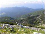
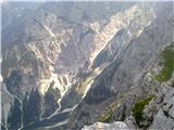
 | Vršič - Prisank / Prisojnik (Slovenian way)
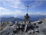
Prisank (also known as Prisojnik) is a 2,547-meter-high mountain situated above the Mlinarica, Krnica, and Suha Pišnica valleys. From the summit,...
3 h 30 min |
| Erjavčeva koča na Vršiču - Prisank / Prisojnik (Slovenska pot)
Prisank (also known as Prisojnik) is a 2,547-meter-high mountain situated above the Mlinarica, Krnica, and Suha Pišnica valleys. From the summit,...
3 h 45 min |
 | end of road on Pokljuka - Triglavski dom na Kredarici
The Triglav Hut at Kredarica is the highest-lying serviced Slovenian mountain hut. It is open all year round but outside the season only on an em...
5 h |
 | B station - Prestreljenik (via Krnica)
Prestreljenik is a 2,499 m high mountain located in the heart of the Kanin range. From the summit, where there is a registration box shaped like ...
4 h 25 min |
| Sella Nevea - Prestreljenik (via Rifugio Gilberti)
Prestreljenik is a 2,499 m high mountain located in the heart of the Kanin range. From the summit, where there is a registration box shaped like ...
4 h 15 min |
| Sella Nevea - Prestreljenik (via 636)
Prestreljenik is a 2,499 m high mountain located in the heart of the Kanin range. From the summit, where there is a registration box shaped like ...
3 h 45 min |
 | The Kot Valley - Begunjski vrh
Begunjski Vrh is a 2,461 m high mountain located in the heart of the highest peaks of the Julian Alps. From the summit, which has a registration ...
4 h 40 min |
 | Bodenbauer - Hochstuhl/Stol
Stol is, at 2,236 m, the highest peak in the Karawanks. From the summit, which has a registration box and stamp, a beautiful view opens onto the ...
4 h 30 min |
| Ogris - Hochstuhl/Stol
Stol is, at 2,236 m, the highest peak in the Karawanks. From the summit, which has a registration box and stamp, a beautiful view opens onto the ...
4 h 30 min |
 | Bodenbauer - Vertatscha/Vrtača
Vrtača is a 2181 m high peak located east of Stol. From the summit, where a large peg stands, a beautiful view opens over parts of the Julian Alp...
4 h 45 min |
| Ogris - Vertatscha/Vrtača
Vrtača is a 2181 m high peak located east of Stol. From the summit, where a large peg stands, a beautiful view opens over parts of the Julian Alp...
4 h 45 min |
 | Jermanca - Planjava (via Kamniško sedlo)
Planjava is a smaller mountain group east of Kamniško sedlo. It has two peaks eastern and western. The marked path leads to the eastern peak, wh...
4 h 30 min |
| Koča pod slapom Rinka - Planjava
Planjava is a smaller mountain group east of Kamniško sedlo. It has two peaks eastern and western. The marked path leads to the eastern peak, wh...
4 h 45 min |
| Planina Podvežak - Planjava (via Srebrno sedlo)
Planjava is a smaller mountain group east of Kamniško sedlo. It has two peaks eastern and western. The marked path leads to the eastern peak, wh...
4 h 15 min |
 | Planina Podvežak - Planjava (via Škarje)
Planjava is a smaller mountain group east of Kamniško sedlo. It has two peaks eastern and western. The marked path leads to the eastern peak, wh...
4 h 45 min |
 | Kraljev dol - Planjava (via Srebrno sedlo)
Planjava is a smaller mountain group east of Kamniško sedlo. It has two peaks eastern and western. The marked path leads to the eastern peak, wh...
4 h 30 min |
 | The Krma Valley - Debela peč
Debela peč is a 2014 m high mountain that rises steeply above the Krma valley on one side and gently descends towards the expansive Pokljuka fore...
3 h 30 min |
 | Dom pod Storžičem - Storžič (via Škarjev rob)
Storžič is a 2132 m high mountain located in the western part of the Kamnik-Savinja Alps. From the summit, where there is a cross, a beautiful vi...
3 h 5 min |
 | Jekarica - Storžič
Storžič is a 2132 m high mountain located in the western part of the Kamnik-Savinja Alps. From the summit, where there is a cross, a beautiful vi...
3 h |
| Tržiški graben - Storžič (via Javorniški preval)
Storžič is a 2132 m high mountain located in the western part of the Kamnik-Savinja Alps. From the summit, where there is a cross, a beautiful vi...
3 h 45 min |
 | Jermanca - Brana (via Kamniško sedlo)
Brana is a mountain above Kamniško sedlo. From the spacious summit, which has a registration box and a small cross, there is a very beautiful vie...
3 h 45 min |
| Koča pod slapom Rinka - Brana
Brana is a mountain above Kamniško sedlo. From the spacious summit, which has a registration box and a small cross, there is a very beautiful vie...
3 h 45 min |
 | Erjavčev rovt - Mittagskogel/Kepa
Kepa (also Jepa, German: Mittagskogel) is a panoramic mountain in the western Karavanke, located on the border ridge between Slovenia and Austria...
3 h 50 min |
| Ravne - Mittagskogel/Kepa
Kepa (also Jepa, German: Mittagskogel) is a panoramic mountain in the western Karavanke, located on the border ridge between Slovenia and Austria...
4 h 15 min |
 | Iličev rovt / Illitsch Rauth - Mittagskogel/Kepa (path 680)
Kepa (also Jepa, German: Mittagskogel) is a panoramic mountain in the western Karavanke, located on the border ridge between Slovenia and Austria...
3 h |
 | V Koncu - Kalška gora
Kalška gora lies between the Kalški greben and Kokrsko sedlo. From the grassy summit there is a beautiful view towards the nearby Kalški greben. ...
3 h 15 min |
| Suhadolnik - Kalška gora
Kalška gora lies between the Kalški greben and Kokrsko sedlo. From the grassy summit there is a beautiful view towards the nearby Kalški greben. ...
3 h 30 min |
| Kriška planina - Kalška gora (via Zvoh)
Kalška gora lies between the Kalški greben and Kokrsko sedlo. From the grassy summit there is a beautiful view towards the nearby Kalški greben. ...
4 h 45 min |
| Dom na Gospincu - Kalška gora (via Zvoh)
Kalška gora lies between the Kalški greben and Kokrsko sedlo. From the grassy summit there is a beautiful view towards the nearby Kalški greben. ...
4 h 45 min |
| Planina Jezerca - Kalška gora (via Dom na Krvavcu and Zvoh)
Kalška gora lies between the Kalški greben and Kokrsko sedlo. From the grassy summit there is a beautiful view towards the nearby Kalški greben. ...
5 h |
 | Planina Podvežak - Ojstrica (via Kocbekov dom)
Ojstrica, named for its sharp shape, rises steeply above Korošica, the Logarska Dolina valley, and Robanov Kot. From the summit, which has a regi...
4 h |
 | Planina Podvežak - Ojstrica (via Mala Ojstrica)
Ojstrica, named for its sharp shape, rises steeply above Korošica, the Logarska Dolina valley, and Robanov Kot. From the summit, which has a regi...
3 h 30 min |
| Planina Ravne - Ojstrica (via Mala Ojstrica)
Ojstrica, named for its sharp shape, rises steeply above Korošica, the Logarska Dolina valley, and Robanov Kot. From the summit, which has a regi...
4 h 15 min |
| Planina Ravne - Ojstrica (via Dolga trata and Mala Ojstrica)
Ojstrica, named for its sharp shape, rises steeply above Korošica, the Logarska Dolina valley, and Robanov Kot. From the summit, which has a regi...
4 h 45 min |
| Kraljev dol - Ojstrica (via Mala Ojstrica)
Ojstrica, named for its sharp shape, rises steeply above Korošica, the Logarska Dolina valley, and Robanov Kot. From the summit, which has a regi...
3 h 45 min |
| Kraljev dol - Ojstrica (via Kocbekov dom)
Ojstrica, named for its sharp shape, rises steeply above Korošica, the Logarska Dolina valley, and Robanov Kot. From the summit, which has a regi...
4 h 15 min |
 | Planina Zapleč - Krn
Krn, at 2244 m, is the highest peak of the Krn mountain group, which rises steeply above the central part of the Soča River. From the summit, fea...
4 h 30 min |
 | Tolminske Ravne - Tolminski Kuk (via planina Razor)
Tolminski Kuk is the highest peak in the Bohinj-Tolmin mountains. The summit, equipped with a registration box, offers a very beautiful view. Fro...
4 h 45 min |
 | Aljažev dom v Vratih - Križ (via Sovatna)
Križ is a 2,140 m high mountain located northeast of the Kriški Podi plateau. The summit, which has a registration box with a stamp, offers a bea...
5 h |
 | The Krma Valley - Brda
Brda is a panoramic peak situated between Pokljuka and Krma. The summit has a stamp attached to a metal pole and offers a beautiful view towards ...
2 h 55 min |
 | Podnar / Bodenbauer - Prešernova koča na Stolu
The Prešernova koča na Stolu mountain hut is located just a few metres below the summit of the 2198 m high Mali Stol. From the hut or the nearby ...
4 h 25 min |
| Vgriz / Ogris - Prešernova koča na Stolu
The Prešernova koča na Stolu mountain hut is located just a few metres below the summit of the 2198 m high Mali Stol. From the hut or the nearby ...
4 h 25 min |
 | Kriška planina - Kalški greben (via Zvoh)
Kalški greben is a 2224 m high peak and the highest point of the ridge bearing the same name. From the summit, where there is a summit register a...
4 h 10 min |
| Dom na Gospincu - Kalški greben (via Zvoh)
Kalški greben is a 2224 m high peak and the highest point of the ridge bearing the same name. From the summit, where there is a summit register a...
4 h 10 min |
| Planina Jezerca - Kalški greben (via Dom na Krvavcu and Zvoh)
Kalški greben is a 2224 m high peak and the highest point of the ridge bearing the same name. From the summit, where there is a summit register a...
4 h 25 min |
 | The Kot Valley - Visoka Vrbanova špica (via Staničev dom)
Visoka Vrbanova špica is located at the far southwestern end of the ridge rising above the Kot and Vrata valleys, and higher up between the Kot a...
4 h 30 min |
 | Vršič - Planja
The Planja summit is located between two alpine valleys: Mlinarica on the north side and Zadnjica on the south. From the summit, there is a beaut...
5 h 5 min |
 | Bodenbauer - Ovčji vrh (Kozjak) / Geissberg (Kosiak) (direct way)
Ovčji Vrh or Kozjak, known in German as Geissberg or Kosiak, is a 2024 m high peak located north of the main Karawanks ridge. Rising above Celovš...
3 h |
| Ogris - Ovčji vrh (Kozjak) / Geissberg (Kosiak) (direct way)
Ovčji Vrh or Kozjak, known in German as Geissberg or Kosiak, is a 2024 m high peak located north of the main Karawanks ridge. Rising above Celovš...
3 h |
| Bodenbauer - Ovčji vrh (Kozjak) / Geissberg (Kosiak) (via Klagenfurter Hütte)
Ovčji Vrh or Kozjak, known in German as Geissberg or Kosiak, is a 2024 m high peak located north of the main Karawanks ridge. Rising above Celovš...
3 h 15 min |
| Ogris - Ovčji vrh (Kozjak) / Geissberg (Kosiak) (via Klagenfurter Hütte)
Ovčji Vrh or Kozjak, known in German as Geissberg or Kosiak, is a 2024 m high peak located north of the main Karawanks ridge. Rising above Celovš...
3 h 15 min |
 | Aljažev dom v Vratih - Bovški Gamsovec (via Luknja)
Bovški Gamsovec is a 2392 m high mountain in the immediate vicinity of Triglav. From the summit there is a magnificent view of Triglav and its no...
4 h 35 min |
| Aljažev dom v Vratih - Bovški Gamsovec (via Sovatna)
Bovški Gamsovec is a 2392 m high mountain in the immediate vicinity of Triglav. From the summit there is a magnificent view of Triglav and its no...
4 h 45 min |
 | Plockenpass - Monte Coglians (Hohe Warte) (via Rifugio Marinelli)
Monte Coglians (Hohe Warte) is, at 2,780 meters, the highest mountain of the Carnic Alps. From the summit, which has a cross and a bell, there is...
5 h |
| Rifugio Tolazzi - Monte Coglians (Hohe Warte) (via Rifugio Marinelli)
Monte Coglians (Hohe Warte) is, at 2,780 meters, the highest mountain of the Carnic Alps. From the summit, which has a cross and a bell, there is...
4 h 25 min |
 | Ravenska Kočna - Velika (Koroška) Baba (via Jenkova planina)
Velika (Koroška) Baba is a 2127 m high mountain on the border ridge above the Ravenska Kočna valley on the Slovenian side and above the Bela (Bel...
3 h 30 min |
 | Sella Nevea - Velika Črnelska špica (on ski track)
Velika Črnelska špica is located in the Kanin mountains on the border between Italy and Slovenia. From the top there is a very nice view of the V...
4 h 30 min |
| Sella Nevea - Velika Črnelska špica (via 636)
Velika Črnelska špica is located in the Kanin mountains on the border between Italy and Slovenia. From the top there is a very nice view of the V...
4 h 45 min |
 | Tolminske Ravne - Vrh nad Škrbino (on steep and direct path)
Vrh nad Škrbino is the easternmost two-thousander in the ridge of the Lower Bohinj Mountains. From the summit, there are excellent views of the n...
3 h 30 min |
 | Goldberg - Torkofel
Torkofel is the highest peak of the panoramic Jauken ridge, which extends north of the Gailtal valley. From the summit cross, there is a nice vie...
3 h 45 min |
 | Reißkofelbad - Reißkofel (via east ridge)
Reißkofel is a 2371 m high mountain in the Gailtal Alps. The summit, marked by a cross, also features a summit register. The view is particularly...
4 h 45 min |
 | Jochalm - Reißkofel (235-1)
Reißkofel is a 2371 m high mountain in the Gailtal Alps. The summit, marked by a cross, also features a summit register. The view is particularly...
3 h |
 | Jochalm - Reißkofel (path 235)
Reißkofel is a 2371 m high mountain in the Gailtal Alps. The summit, marked by a cross, also features a summit register. The view is particularly...
3 h 25 min |
 | Reißkofelbad - Kleiner Reißkofel
Kleiner Reißkofel is a 2,161-meter-high mountain east of Reißkofel. From the summit, where a cross stands, there are fine views of the nearby Rei...
3 h 30 min |
 | Göriach - Scharnock
Scharnock is a panoramic peak located in the Schladminger Tauern group. From the summit, where a cross stands, there is a nice view of the surrou...
3 h 30 min |
 | Göriach - Hochgolling (Normalanstieg)
Hochgolling is a 2863 m high peak (2862 m according to some sources), located in the heart of the Schladminger Tauern group. With its height, it ...
4 h |
 | NC Planica - Srednja Ponca / Ponza di Mezze
Srednja Ponca is a 2,228-meter-high peak rising steeply above Tamar, Planica, and Mangartska Dolina. From the summit, which has a stamp, there ar...
4 h |
 | Plockenpass - Monte Floriz
Monte Floriz is a 2,184 m high grassy peak located south of the Marinelli hut. From the summit there is a very nice view of the Coglians group; i...
3 h |
 | Cave del Mole - Koštrunove špice (via Forcella Lavinal dell Orso)
Koštrunove špice is a 2,502-meter-high peak located southwest of Viš (2,666 m). From the summit, a beautiful view opens up over much of the weste...
4 h |
| Cave del Mole - Koštrunove špice (via Forcella Mose)
Koštrunove špice is a 2,502-meter-high peak located southwest of Viš (2,666 m). From the summit, a beautiful view opens up over much of the weste...
4 h |
 | Planina Pecol - Strma peč / Monte Cimone (path 640 via notch Vandul)
Strma Peč is located west of Montaž, more precisely between the Reklanica and Dunja valleys. From the summit, where a bivouac once stood, there i...
4 h |
 | Planina Pecol - Strma peč / Monte Cimone (path 641 on the slope of Viene)
Strma Peč is located west of Montaž, more precisely between the Reklanica and Dunja valleys. From the summit, where a bivouac once stood, there i...
4 h 45 min |
 | Tolminske Ravne - Zeleni vrh (via planina Razor)
Zeleni vrh is a 2052-meter-high mountain located east of the highest peak of the Spodnje Bohinjske gore. From the grassy summit, which drops prec...
4 h 20 min |
 | Rifugio Pederü - Croda del Beco / Seekofel
Croda del Beco (German: Seekofel, Ladin: Sass dla Porta) is a 2,810-meter-high mountain that rises steeply above Lago di Braies (Pragser Wildsee)...
3 h 45 min |
| Rifugio Ra Stua - Croda del Beco / Seekofel
Croda del Beco (German: Seekofel, Ladin: Sass dla Porta) is a 2,810-meter-high mountain that rises steeply above Lago di Braies (Pragser Wildsee)...
3 h 35 min |
 | Fiames - Punta Fiames
Punta Fiames is a 2,240-meter-high peak located north of Cortina d'Ampezzo. The mountain is popular mainly among fans of via ferrata routes, as a...
3 h 30 min |
 | Coot Parking Lot - Velika Baba (Kanin) (over Zg. Brda and saddle Med Baban)
Velika Baba is the southernmost two-thousander of the Kanin mountains. It is separated from the main ridge to the north by the saddle Med Baban, ...
3 h 15 min |
 | Coot Parking Lot - Velika Baba (Kanin) (via Skutnik)
Velika Baba is the southernmost two-thousander of the Kanin mountains. It is separated from the main ridge to the north by the saddle Med Baban, ...
4 h 20 min |
 | Plockenpass - Cima di Mezzo / Keller Warte (via Rifugio Marinelli)
Cima di Mezzo (German: Keller Warte) is a 2,713-meter-high mountain in the Carnic Alps on the border between Austria and Italy. A small cross and...
4 h 35 min |
| Rifugio Tolazzi - Cima di Mezzo / Keller Warte (via Rifugio Marinelli)
Cima di Mezzo (German: Keller Warte) is a 2,713-meter-high mountain in the Carnic Alps on the border between Austria and Italy. A small cross and...
4 h |
 | Bergheimat - Dachskofel (via Scharnik)
Dachskofel is a 2,373 m high mountain in Austria's Hohe Tauern above the town of Irschen and near Lamnitzsee. A wooden cross stands on the summit...
3 h 50 min |
 | end of road on Pokljuka - Kredarica
Kredarica is a 2,541-meter-high panoramic peak located between Triglav and Rž. From the summit, a nice view opens up towards Triglav and the surr...
5 h 5 min |
 | Weißenbach - Spitzegel / Negal (via Bodenalm)
Spitzegel / Negal is a 2,119 m high mountain in the Gailtal Alps in Austria. The ridge with its highest peak Spitzegel / Nagal logically connects...
4 h 30 min |
 | Passo di Sant'Antonio - Monte Aiarnola (via normale)
Monte Aiarnola is a mountain at the far eastern end of the Sexten Dolomites group. From it there is a nice view towards the western Carnic Alps, ...
3 h 30 min |
 | Gschnitz - Kalkwand (western approach from Gschnitza via Pinnisjoch)
Kalkwand is an extensive mountain in the eastern part of the Habicht group in the central Stubai Alps. Due to its attractive views, relatively ea...
3 h 45 min |
 | Planina Zapleč - Srednji vrh (at Krn)
Srednji vrh is a 2134-meter-high peak located in the ridge between Krn and Krnčica. A marked path leads to the summit, which offers very nice vie...
3 h 10 min |
 | Ruski križ - Lipnica (via Koča v Krnici)
Lipnica is a high-mountain peak standing in the immediate vicinity of Špik and representing its southern neighbour. It lies on the ridge that des...
4 h 15 min |