 | Šmartno - Šmarna gora (Šmartinska way)
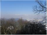
Šmarna gora is a 669 m peak northwest of Slovenia's capital. From the summit, with its restaurant and church, there is a beautiful view over Gore...
50 min |
 | Tacen - Šmarna gora (via Spodnja Kuhinja)
Šmarna gora is a 669 m peak northwest of Slovenia's capital. From the summit, with its restaurant and church, there is a beautiful view over Gore...
55 min |
 | Šmartno - Šmarna gora (Partizanska way)
Šmarna gora is a 669 m peak northwest of Slovenia's capital. From the summit, with its restaurant and church, there is a beautiful view over Gore...
45 min |
 | Vikrče - Šmarna gora (via Zatrep)
Šmarna gora is a 669 m peak northwest of Slovenia's capital. From the summit, with its restaurant and church, there is a beautiful view over Gore...
1 h 10 min |
 | Tacen - Šmarna gora (Partizanska steza)
Šmarna gora is a 669 m peak northwest of Slovenia's capital. From the summit, with its restaurant and church, there is a beautiful view over Gore...
1 h |
| Tacen (Sveti Jurij) - Šmarna gora (Romarska pot)
Šmarna gora is a 669 m peak northwest of Slovenia's capital. From the summit, with its restaurant and church, there is a beautiful view over Gore...
1 h |
| Tacen (Sveti Jurij) - Šmarna gora (Partizanska steza)
Šmarna gora is a 669 m peak northwest of Slovenia's capital. From the summit, with its restaurant and church, there is a beautiful view over Gore...
1 h |
| Lipa - Šmarna gora (path via Peski)
Šmarna gora is a 669 m peak northwest of Slovenia's capital. From the summit, with its restaurant and church, there is a beautiful view over Gore...
55 min |
| Lipa - Šmarna gora (by road)
Šmarna gora is a 669 m peak northwest of Slovenia's capital. From the summit, with its restaurant and church, there is a beautiful view over Gore...
1 h 5 min |
 | Vikrče - Šmarna gora (Kovačeva steza)
Šmarna gora is a 669 m peak northwest of Slovenia's capital. From the summit, with its restaurant and church, there is a beautiful view over Gore...
1 h 10 min |
| Spodnje Pirniče - Šmarna gora (Kovačeva steza)
Šmarna gora is a 669 m peak northwest of Slovenia's capital. From the summit, with its restaurant and church, there is a beautiful view over Gore...
1 h 10 min |
| Spodnje Pirniče - Šmarna gora (learning trail)
Šmarna gora is a 669 m peak northwest of Slovenia's capital. From the summit, with its restaurant and church, there is a beautiful view over Gore...
1 h 10 min |
 | Legastja - Sveti Jakob
The Church of St. James is located on a scenic hill north of the village of Topol pri Medvodah. From the summit, which features a registration bo...
1 h 10 min |
 | Legastja - Sveti Jakob (north path)
The Church of St. James is located on a scenic hill north of the village of Topol pri Medvodah. From the summit, which features a registration bo...
1 h |
 | Rašica - Rašica (Vrh Staneta Kosca) (by road)
Vrh Staneta Kosca, better known as Rašica, is located north of Ljubljana, more precisely above the villages of Rašica and Dobeno. From the summit...
55 min |
| Rašica - Rašica (Vrh Staneta Kosca) (footpath)
Vrh Staneta Kosca, better known as Rašica, is located north of Ljubljana, more precisely above the villages of Rašica and Dobeno. From the summit...
55 min |
 | Spodnje Dobeno - Rašica (Vrh Staneta Kosca)
Vrh Staneta Kosca, better known as Rašica, is located north of Ljubljana, more precisely above the villages of Rašica and Dobeno. From the summit...
50 min |
 | Kranj (Kalvarija) - Šmarjetna gora (by road)
Šmarjetna gora is a panoramic peak rising above Kranj. From the summit, where the Church of St. Margaret and the Hotel Bellevue stand, a beautifu...
40 min |
 | Ljubljana (Podutik) - Toško Čelo
Toško Čelo is a 590-metre hill above the village of the same name. From the summit, or slightly below it, a beautiful view opens over part of Lju...
1 h |
 | Žlebe - Jeterbenk (via Turnice)
Jeterbenk is a 774-meter-high peak located between the Slavkov dom hut on Golo Brdo and Katarina (the village of Topol). From the summit, where t...
1 h |
 | Žlebe - Jeterbenk (on ridge)
Jeterbenk is a 774-meter-high peak located between the Slavkov dom hut on Golo Brdo and Katarina (the village of Topol). From the summit, where t...
1 h 5 min |
 | Vrzdenec - Kožljek
Kožljek is a 788 m high peak located west of Koren, more precisely above the village of Samotorica. From the summit, where there are several benc...
1 h 5 min |
 | Ljubljanica - Kožljek
Kožljek is a 788 m high peak located west of Koren, more precisely above the village of Samotorica. From the summit, where there are several benc...
45 min |
 | Preval Prosca - Koreno (steep path)
Koreno (also known as Korena) is a 729 m high hill located north of Horjul. From the summit, which features a large cross, the church of St. Moho...
1 h |
 | Horjul - Koreno (gentle path)
Koreno (also known as Korena) is a 729 m high hill located north of Horjul. From the summit, which features a large cross, the church of St. Moho...
1 h 5 min |
 | Briše - Koreno
Koreno (also known as Korena) is a 729 m high hill located north of Horjul. From the summit, which features a large cross, the church of St. Moho...
50 min |
| Horjul - Koreno (steep path)
Koreno (also known as Korena) is a 729 m high hill located north of Horjul. From the summit, which features a large cross, the church of St. Moho...
1 h |
 | Sora - Hom (footpath)
Hom is a 715 m high peak that rises steeply southwest of the village of Sora. From the summit, which is partly forested, there is a beautiful vie...
50 min |
 | Sora - Hom (by road)
Hom is a 715 m high peak that rises steeply southwest of the village of Sora. From the summit, which is partly forested, there is a beautiful vie...
1 h 5 min |
 | Sora - Hom (less steep path)
Hom is a 715 m high peak that rises steeply southwest of the village of Sora. From the summit, which is partly forested, there is a beautiful vie...
55 min |
 | Skalnica - Sveta Gora (by road)
Sveta Gora is known mainly among believers and locals. It is a well-known pilgrimage center above Nova Gorica. Believers come here from all over ...
1 h |
 | Skalnica - Sveta Gora (footpath)
Sveta Gora is known mainly among believers and locals. It is a well-known pilgrimage center above Nova Gorica. Believers come here from all over ...
55 min |
 | Šmartno - Grmada
Grmada is a 676-meter-high mountain located west of the much more visited Šmarna gora. From the summit, which has a small takeoff area, a beautif...
55 min |
| Tacen - Grmada (via Spodnja Kuhinja)
Grmada is a 676-meter-high mountain located west of the much more visited Šmarna gora. From the summit, which has a small takeoff area, a beautif...
1 h |
 | Vikrče - Grmada (Mazijeva steza)
Grmada is a 676-meter-high mountain located west of the much more visited Šmarna gora. From the summit, which has a small takeoff area, a beautif...
1 h 5 min |
| Tacen - Grmada (Mazijeva steza)
Grmada is a 676-meter-high mountain located west of the much more visited Šmarna gora. From the summit, which has a small takeoff area, a beautif...
1 h 10 min |
 | Tacen (Sveti Jurij) - Grmada
Grmada is a 676-meter-high mountain located west of the much more visited Šmarna gora. From the summit, which has a small takeoff area, a beautif...
1 h 5 min |
 | Vikrče - Grmada (Kovačeva steza)
Grmada is a 676-meter-high mountain located west of the much more visited Šmarna gora. From the summit, which has a small takeoff area, a beautif...
1 h 10 min |
 | Lipa - Grmada (path via Peski)
Grmada is a 676-meter-high mountain located west of the much more visited Šmarna gora. From the summit, which has a small takeoff area, a beautif...
1 h |
| Lipa - Grmada (by road)
Grmada is a 676-meter-high mountain located west of the much more visited Šmarna gora. From the summit, which has a small takeoff area, a beautif...
1 h 10 min |
 | Gabrje - Limbarska gora (footpath)
Limbarska gora is located northeast of Moravče. From the summit, there is a beautiful view of the surrounding peaks, and in good weather, the Kam...
45 min |
 | Kuren - Koča na Planini nad Vrhniko
Planina nad Vrhniko is for Vrhnika locals something like Šmarna gora for those from Ljubljana. It is 733 m high, reachable by several paths from ...
45 min |
 | Star maln - Koča na Planini nad Vrhniko
Planina nad Vrhniko is for Vrhnika locals something like Šmarna gora for those from Ljubljana. It is 733 m high, reachable by several paths from ...
1 h |
 | Katarija - Sveti Miklavž above Sava
The Church of St. Miklavž is situated on a panoramic hill south of Moravče. From the summit, there is a beautiful view toward the nearby Limbarsk...
45 min |
 | Kuren - Ulovka
Ulovka is a peak between Zaplana and Zavetišče na Planini nad Vrhniko. From the summit, to which ski lifts run, there is a nice view to the north...
50 min |
 | Preval Prosca - Ključ
Ključ is a forest-covered peak located north of the village Brezje pri Dobrovi and south of Dolenja vas. The summit, which has a stamp box with l...
1 h |
 | Dolenja vas (Kosmulj) - Ključ
Ključ is a forest-covered peak located north of the village Brezje pri Dobrovi and south of Dolenja vas. The summit, which has a stamp box with l...
1 h 10 min |
 | Sveti Urh - Ključ
Ključ is a forest-covered peak located north of the village Brezje pri Dobrovi and south of Dolenja vas. The summit, which has a stamp box with l...
1 h |
 | Podgorje - Kojnik (steep path)
Kojnik is a partly forested peak located in the southern part of Podgorski Kras near the Slovenian-Croatian border. From the summit, which has a ...
1 h |
 | Zazid - Jampršnik
Jampršnik is a little-known and even less visited peak located in the mountain chain southwest of Črni Kal. Despite its modest height, there is a...
1 h |
 | Krnice - Dom v Gorah
The Dom v Gorah mountain hut is located east of Hrastnik, just a few meters below the 786 m high peak where the church of St. Jurij stands. From ...
1 h 5 min |
 | Vratca - Škabrijel
Škabrijel is a hill northeast of the town of Gorica. Since the vegetation on the summit was cleared and a tall metal observation tower was erecte...
40 min |
| Kekec - Škabrijel
Škabrijel is a hill northeast of the town of Gorica. Since the vegetation on the summit was cleared and a tall metal observation tower was erecte...
50 min |
 | Prevala - Škabrijel (via Veliki hrib)
Škabrijel is a hill northeast of the town of Gorica. Since the vegetation on the summit was cleared and a tall metal observation tower was erecte...
1 h 5 min |
| Prevala - Škabrijel
Škabrijel is a hill northeast of the town of Gorica. Since the vegetation on the summit was cleared and a tall metal observation tower was erecte...
50 min |
| Prevala - Škabrijel (via Hungarian pyramid)
Škabrijel is a hill northeast of the town of Gorica. Since the vegetation on the summit was cleared and a tall metal observation tower was erecte...
1 h |
 | Dobrič - Gora Oljka
Gora Oljka is a hill located east of Šmartno ob Paki. On the summit stands the Church of the Holy Cross, built in the mid-18th century. Just a fe...
50 min |
 | Dobrič (Vedet) - Gora Oljka (via Rogeljšek)
Gora Oljka is a hill located east of Šmartno ob Paki. On the summit stands the Church of the Holy Cross, built in the mid-18th century. Just a fe...
40 min |
| Dobrič (Vedet) - Gora Oljka (via Brezovec)
Gora Oljka is a hill located east of Šmartno ob Paki. On the summit stands the Church of the Holy Cross, built in the mid-18th century. Just a fe...
50 min |
 | Migojnice - Dom na Bukovici
The mountain hut Dom na Bukovici is situated just a few meters below the summit of the forested Bukovica. From the hut, near which there is a lar...
45 min |
 | Zabukovica - Dom na Bukovici
The mountain hut Dom na Bukovici is situated just a few meters below the summit of the forested Bukovica. From the hut, near which there is a lar...
45 min |
 | Kasaze - Dom na Bukovici
The mountain hut Dom na Bukovici is situated just a few meters below the summit of the forested Bukovica. From the hut, near which there is a lar...
45 min |
 | Šešče pri Preboldu - Dragov dom na Homu (via Lajnarjev hrib)
Dragov dom is located on a scenic hill south of Šempeter. From the summit, where there is also the Church of St. Magdalena, there is a fine panor...
1 h |
 | Gora - Trstelj
Trstelj is the highest peak in the ridge of Črni hribi. From the spacious summit, which has TV transmitters, the view is divided. From the north ...
50 min |
 | Lipa - Trstelj
Trstelj is the highest peak in the ridge of Črni hribi. From the spacious summit, which has TV transmitters, the view is divided. From the north ...
40 min |
 | Košnica - Veliki Slomnik
Veliki Slomnik is a peak located between Košnica pri Celju and Liboje. The summit has a logbook box, but due to the surrounding forest, there are...
40 min |
 | Žička kartuzija - Skala
Skala is a viewpoint on the eastern part of Konjiška gora. From this vantage point, equipped with a table, bench, and logbook box, there is a nic...
1 h |
 | Grad Pišece - Veliki Špiček
Veliki Špiček is the highest peak of Brežice municipality. From the top a nice view spreads towards the south and east. Most of Brežice municipal...
1 h 5 min |
 | border crossing Lipica - Kokoš (steep way)
The Koča na Kokoši mountain hut is located on Jirmanec peak, just 5 minutes from the forested Kokoš. From the summit, situated south of Lokavsko ...
50 min |
| border crossing Lipica - Kokoš (by road)
The Koča na Kokoši mountain hut is located on Jirmanec peak, just 5 minutes from the forested Kokoš. From the summit, situated south of Lokavsko ...
1 h |
 | Lipica (Škibini) - Kokoš
The Koča na Kokoši mountain hut is located on Jirmanec peak, just 5 minutes from the forested Kokoš. From the summit, situated south of Lokavsko ...
50 min |
 | Pesek / Pese - Kokoš
The Koča na Kokoši mountain hut is located on Jirmanec peak, just 5 minutes from the forested Kokoš. From the summit, situated south of Lokavsko ...
40 min |
 | Podgora - Kamen vrh
Kamen Vrh is a panoramic hill located on the northern edge of Mala Gora. From the summit, surrounded by low bushes, there are fine views of parts...
1 h |
 | Podpeč - Kamen vrh
Kamen Vrh is a panoramic hill located on the northern edge of Mala Gora. From the summit, surrounded by low bushes, there are fine views of parts...
50 min |
 | Šober - Tojzlov vrh
Tojzlov vrh is a forested hill on the eastern part of Kozjak. On the summit stands a small stone NOB monument and, more recently, also a summit l...
1 h |
| Šober (Log) - Tojzlov vrh
Tojzlov vrh is a forested hill on the eastern part of Kozjak. On the summit stands a small stone NOB monument and, more recently, also a summit l...
50 min |
 | Vitovlje - Vitovski hrib (west path)
Vitovski hrib is a 604-meter-high hill located north of the village Vitovlje in the Vipava Valley. From the summit, where there is a church dedic...
40 min |
 | Vitovlje - Vitovski hrib (via Vitovlje Lake)
Vitovski hrib is a 604-meter-high hill located north of the village Vitovlje in the Vipava Valley. From the summit, where there is a church dedic...
40 min |
 | Adergas - Štefanja gora (via benches)
Štefanja gora, where the Church of St. Stephen stands, is located above Cerklje na Gorenjskem. Just a few tens of meters below the summit lies th...
1 h |
 | Adergas - Štefanja gora (via šterna)
Štefanja gora, where the Church of St. Stephen stands, is located above Cerklje na Gorenjskem. Just a few tens of meters below the summit lies th...
1 h |
 | Olševek - Štefanja gora
Štefanja gora, where the Church of St. Stephen stands, is located above Cerklje na Gorenjskem. Just a few tens of meters below the summit lies th...
55 min |
 | Velesovo - Štefanja gora (via benches)
Štefanja gora, where the Church of St. Stephen stands, is located above Cerklje na Gorenjskem. Just a few tens of meters below the summit lies th...
1 h 10 min |
| Velesovo - Štefanja gora (via Šterna)
Štefanja gora, where the Church of St. Stephen stands, is located above Cerklje na Gorenjskem. Just a few tens of meters below the summit lies th...
1 h 10 min |
 | Mekinje nad Stično - Pristava above Stična
Pristava nad Stično is a small village on a scenic rise north of Stična. Slightly above the village near the Partizanski dom lies a broad, panora...
1 h 5 min |
 | Belica - Kregovnik
Kregovnik is a lesser-known peak on the southeastern ridge of the 898-meter-high Polhograjska Grmada. From its mostly forested summit, there are ...
1 h |
 | Legastja - Sveti Florijan (Tehovec)
The Church of St. Florijan is a subsidiary church located in the village of Tehovec above Medvode. From the church, first mentioned in 1548, a ni...
50 min |
 | Blagovica - Golčaj
Golčaj is a 690 m high hill rising south of Blagovica. At the summit, which has a logbook box and stamp, stands a NOB monument; a few tens of met...
40 min |
 | Kropa - Sveti Primož in Felicijan (Jamnik)
The Church of St. Primož and Felicijan at Jamnik is located on a scenic grassy ridge rising between Kropa and Podblica. From the church or its ne...
1 h 10 min |
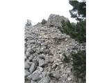
 | Beli Potok at Frankolovo - Lindek Castle
Lindek Castle, first mentioned in 1264, is located on Grajski hrib (Castle Hill), north of Frankolovo. From the summit, where only ruins of the f...
45 min |
 | Narin - Šilentabor
Šilentabor is a 751-meter-high peak just above the village of the same name. From the summit, near which there is a bench and a logbook box, ther...
1 h |
 | Krvavi Potok - Veliko Gradišče
Veliko Gradišče is a 742-meter-high peak south of the village Lokev on the Karst and east of Kokoš. From the summit, marked by a concrete boulder...
1 h |
 | Prelože pri Lokvi - Veliko Gradišče
Veliko Gradišče is a 742-meter-high peak south of the village Lokev on the Karst and east of Kokoš. From the summit, marked by a concrete boulder...
45 min |
 | Log - Pečke (steep path)
Pečke is an easily accessible peak that has seen fewer visitors lately, located north of the main Pohorje ridge. It gets more visits only on May ...
1 h |
 | Velesovo - Apnišče (via Šterna)
Apnišče is a 740 m high mountain between Možjanca and Štefanja gora. It is the highest point of the Šenčur municipality. The forested summit offe...
1 h 10 min |
 | Zreče (Terme Zreče) - Brinjeva gora (above Zreče) (on PP1)
Brinjeva gora is a prominent hill situated between Zreče and Oplotnica. It is known for several churches located along its entire ridge. Several ...
45 min |
| Zreče (Terme Zreče) - Brinjeva gora (above Zreče) (via farm Pudgrošek)
Brinjeva gora is a prominent hill situated between Zreče and Oplotnica. It is known for several churches located along its entire ridge. Several ...
50 min |
 | Zreče (Terme Zreče) - Brinjeva gora (above Zreče) (via Golika)
Brinjeva gora is a prominent hill situated between Zreče and Oplotnica. It is known for several churches located along its entire ridge. Several ...
1 h |
 | Oplotnica - Sveti Mohor (Lačna Gora)
The Church of St. Mohor and Fortunat is situated on a 602-meter-high hill above the settlement Lačna Gora. In front of the church there is a logb...
45 min |
 | Ljubnica - Golek (zgornja pot)
Golek is a 769-meter-high peak located northwest of Zreče. The summit has a logbook box with book and stamp, plus a bench; a short distance (a fe...
45 min |
 | Zreče (Terme Zreče) - Sveti Martin (Zlakova) (on PP1)
The Church of St. Martin is situated on a panoramic hill on the edge of Zlakova village. From the church, a nice view opens up towards part of Po...
55 min |
 | Zreče (Terme Zreče) - Golika
Golika is a 609-meter-high peak on Brinjeva gora, on which stands the church of St. Neža....
50 min |
 | Bad Gleichenberg (Eichgraben Weg) - Gleichenberger Kogel (via Mühlsteinbruch)
Gleichenberger Kogel is a 598-meter-high mountain of volcanic origin located above Bad Gleichenberg in Styria....
1 h 10 min |
| Bad Gleichenberg (Eichgraben Weg) - Gleichenberger Kogel
Gleichenberger Kogel is a 598-meter-high mountain of volcanic origin located above Bad Gleichenberg in Styria....
1 h 5 min |
 | Gleichenberg Dorf - Gleichenberger Kogel
Gleichenberger Kogel is a 598-meter-high mountain of volcanic origin located above Bad Gleichenberg in Styria....
50 min |
 | Straßengel - Frauenkogel
Frauenkogel is a 683-meter-high hill in the western part of the Graz mountains in Steiermark.The hill is located not far northwest of Graz.On the...
1 h 10 min |
 | Straßengel - Frauenkogel (path no. 1)
Frauenkogel is a 683-meter-high hill in the western part of the Graz mountains in Steiermark.The hill is located not far northwest of Graz.On the...
45 min |
 | Lovnik - Rančka
Rančka is a 615-meter-high peak located west to southwest of Boč. Just below the summit is a stamp box with a bench nearby; the highest point its...
1 h |
| Šentjanž - Leskovški hrib
Leskovški hrib is a 721-meter peak in Posavsko hribovje above the Church of Our Lady of Sorrows in Leskovec, Podboršt. From the top there is a be...
1 h |
 | Donji Borki - Petrov vrh above Daruvar
Petrov vrh is one of the peaks on Papuk Mountain. It is located above the town of Daruvar and is a popular destination for local residents. There...
1 h |
 | Grad Pišece - Intermedija (via Velika bukva)
Intermedija is a 662-meter-high peak in the Orlica range. From the summit, there is a beautiful view mainly to the north and northeast, where on ...
1 h 5 min |