 | Topol - Polhograjska Grmada
Polhograjska Grmada is an 898 m high peak located in the heart of the Polhograjski Dolomites. From the summit, where there is a registration box ...
1 h 15 min |
 | Topol - Sveti Jakob (via homestead Na Vihri)
The Church of St. James is located on a scenic hill north of the village of Topol pri Medvodah. From the summit, which features a registration bo...
45 min |
 | Tourist farm Gonte - Tošč
Tošč, which became the highest peak of the Polhov Gradec Hills decades ago when the Yugoslav army lowered Pasja ravan by 9 metres, is located nor...
45 min |
 | Zapotok - Kurešček
Kurešček is an 826 m high peak located south of Ig and southwest of Želimlje. From the summit, where a church stands, there is no view due to the...
45 min |
 | Čepulje - Sveti Jošt above Kranj
Sveti Jošt above Kranj is a hill located west of the slightly lower Šmarjetna gora. From the summit, where the Church of St Jošt stands alongside...
45 min |
 | Dom na Govejku - Osolnik
Osolnik is an 858-metre-high mountain located south of Škofja Loka and west of Medvode. From the summit, where the Church of St Mohor and Fortuna...
1 h |
 | Praproče - Polhograjska Gora (Sveti Lovrenc) (gentle path)
Polhograjska Gora, also known simply as Gora or Sveti Lovrenc, is an 824 m high hill northwest of Polhov Gradec. The summit, topped by the Church...
50 min |
 | Ljubljanica - Kožljek
Kožljek is a 788 m high peak located west of Koren, more precisely above the village of Samotorica. From the summit, where there are several benc...
45 min |
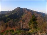
 | Črni Vrh - Pasja ravan
Pasja ravan is the second-highest peak in the Polhograjsko hribovje. A few decades ago, at 1029 meters, it was the highest, but in the second hal...
1 h |
 | Gabrje - Limbarska gora (footpath)
Limbarska gora is located northeast of Moravče. From the summit, there is a beautiful view of the surrounding peaks, and in good weather, the Kam...
45 min |
 | Selo - Sveti Ožbolt (above Zminec)
Sveti Ožbolt is situated on a panoramic rise in the north of the Polhograjski Dolomiti. There is a beautiful view toward the Škofjeloško hribovje...
1 h 15 min |
 | Sv. Andrej - Sveti Ožbolt (above Zminec)
Sveti Ožbolt is situated on a panoramic rise in the north of the Polhograjski Dolomiti. There is a beautiful view toward the Škofjeloško hribovje...
1 h |
 | Selo - Mlaka
Mlaka or Prosenov grič is a forested peak between Pasja ravan and Tošč. Due to the forest, the peak has no view....
1 h 10 min |
 | Čepulje - Archangel Gabriel (Planica)
Planica is an 824-meter-high peak located north of Škofja Loka, more precisely between Križna gora and Planica. From the summit, where the church...
50 min |
 | Smrečje - Vrh Svetih Treh Kraljev (by road)
The Church of the Holy Three Kings stands on a panoramic hill above the village of Vrh Svetih Treh Kraljev. The summit features a panorama board ...
45 min |
 | Smrečje - Vrh Svetih Treh Kraljev (via Jereb)
The Church of the Holy Three Kings stands on a panoramic hill above the village of Vrh Svetih Treh Kraljev. The summit features a panorama board ...
45 min |
| Račevsko jezero - Vrh Svetih Treh Kraljev
The Church of the Holy Three Kings stands on a panoramic hill above the village of Vrh Svetih Treh Kraljev. The summit features a panorama board ...
45 min |
 | Kuren - Koča na Planini nad Vrhniko
Planina nad Vrhniko is for Vrhnika locals something like Šmarna gora for those from Ljubljana. It is 733 m high, reachable by several paths from ...
45 min |
 | Katarija - Sveti Miklavž above Sava
The Church of St. Miklavž is situated on a panoramic hill south of Moravče. From the summit, there is a beautiful view toward the nearby Limbarsk...
45 min |
 | Križevska vas - Cicelj (via farm Buven)
Cicelj is a forest-covered peak located between Moravče and the village of Senožeti. From the summit, which has a bench and a logbook box, there ...
45 min |
 | Kuren - Ulovka
Ulovka is a peak between Zaplana and Zavetišče na Planini nad Vrhniko. From the summit, to which ski lifts run, there is a nice view to the north...
50 min |
 | Zaplana (St. Urh and St. Martin) - Ulovka
Ulovka is a peak between Zaplana and Zavetišče na Planini nad Vrhniko. From the summit, to which ski lifts run, there is a nice view to the north...
50 min |
 | Podgorje - Kojnik (steep path)
Kojnik is a partly forested peak located in the southern part of Podgorski Kras near the Slovenian-Croatian border. From the summit, which has a ...
1 h |
 | Pivka - Osojnica
Osojnica is a forested hill located west of Pivka. The summit features a logbook box, stamp, and bench, but offers no views....
1 h |
 | Vrbiški dol - Koča na Kozleku
The Koča na Kozleku mountain hut is situated southwest of Ilirska Bistrica, just a few meters below the summit of Kozlek. From the summit, there ...
1 h |
 | Ledine - Sivka
Sivka is a forested peak located west of Žiri and north of Idrija. At the summit there is a stamp for the Slovenian Mountain Trail and a logbook ...
45 min |
 | Rudijev dom na Donački gori - Donačka gora
Donačka gora is a peak located north of Rogatec. From the summit, which geographically belongs to the Karawanks, there is a nice view of the near...
45 min |
 | Dobrič (Vedet) - Gora Oljka (via Brezovec)
Gora Oljka is a hill located east of Šmartno ob Paki. On the summit stands the Church of the Holy Cross, built in the mid-18th century. Just a fe...
50 min |
 | Komarna vas - Gače
Gače is a popular excursion spot for nature lovers and the only ski center in Dolenjska (SC Bela), offering pleasant skiing in winter and enjoyab...
1 h |
 | Mali Log - Koča na Kamnem griču
The Koča na Kamnem griču mountain hut is located on Kamni grič, a panoramic hill rising southwest of Sodražica. From the grassy summit surrounded...
50 min |
 | Lom - Koča na Kamnem griču
The Koča na Kamnem griču mountain hut is located on Kamni grič, a panoramic hill rising southwest of Sodražica. From the grassy summit surrounded...
45 min |
| Hrib-Loški Potok - Koča na Kamnem griču
The Koča na Kamnem griču mountain hut is located on Kamni grič, a panoramic hill rising southwest of Sodražica. From the grassy summit surrounded...
1 h 15 min |
 | Bločice - Križna gora
Križna gora is a partly panoramic peak located above the villages of Sveta Ana and Podlož. From the summit, where the Church of the Holy Cross st...
1 h 15 min |
 | Blečji vrh - Kucelj
Kucelj is a 748-meter-high peak situated north of Višnja gora. From the summit, where there is a small geodetic tower with a nearby stamp, there ...
45 min |
 | Leskovec - Obolno
Obolno is a 776-meter-high peak located southwest of the eponymous village. From the grassy summit, by which a radio club hut stands, there is a ...
1 h |
 | Mala Goričica - Obolno
Obolno is a 776-meter-high peak located southwest of the eponymous village. From the grassy summit, by which a radio club hut stands, there is a ...
1 h 10 min |
| Mala Goričica - Obolno (by road)
Obolno is a 776-meter-high peak located southwest of the eponymous village. From the grassy summit, by which a radio club hut stands, there is a ...
1 h 15 min |
 | Zagrad - Ostrič
Ostrič (marked as Žabnik on some maps) is a 1056 m high peak on the Slovenian side of Čičarija. From the bare summit, where there is a round summ...
1 h 5 min |
 | Dule - Kamen vrh
Kamen Vrh is a panoramic hill located on the northern edge of Mala Gora. From the summit, surrounded by low bushes, there are fine views of parts...
45 min |
 | Velike Lašče - Kamen vrh
Kamen Vrh is a panoramic hill located on the northern edge of Mala Gora. From the summit, surrounded by low bushes, there are fine views of parts...
1 h 15 min |
 | Sveta Trojica - Murovica
Murovica is a popular excursion point, accessible from the Posavje side, Domžale, or the Moravška Valley. On the summit there is a bench and a lo...
45 min |
 | Križevska vas - Murovica
Murovica is a popular excursion point, accessible from the Posavje side, Domžale, or the Moravška Valley. On the summit there is a bench and a lo...
45 min |
 | Olševek - Štefanja gora
Štefanja gora, where the Church of St. Stephen stands, is located above Cerklje na Gorenjskem. Just a few tens of meters below the summit lies th...
55 min |
 | Mislinja - Črepič
Črepič is an 798-meter-high peak west of Mislinja. The summit is forested and offers no view, but there is an expansive panorama from a nearby me...
45 min |
 | Lipa - Smolnik
Smolnik is a 1002-meter-high mountain situated between Menina planina and Dobrovlje. From the summit, where there is a bench, a stamp box and a s...
55 min |
 | Hotedršica - Medvedje Brdo
Medvedje Brdo is a small settlement located north of Hotedršica. The highest point of the village is a pleasant viewpoint on Šinkovcov grič (814 ...
1 h 15 min |
 | Rovte - Medvedje Brdo (via Kamnikov Grič)
Medvedje Brdo is a small settlement located north of Hotedršica. The highest point of the village is a pleasant viewpoint on Šinkovcov grič (814 ...
1 h 15 min |
 | Borovec pri Kočevski Reki - Krempa
Krempa is a 944 m high mountain located in the central part of Borovška gora, a range that rises steeply above Zgornja Kolpska dolina. On the sum...
50 min |
 | Petrovo Brdo - Kup
Kup is a 1,046-meter-high peak located between Petrovo Brdo and Podbrdo. From the summit, which features a cross and several transmitters, there ...
45 min |
 | Suhi Dol - Goli vrh (Official marked path)
Goli vrh (also Golni vrh on maps) is an indistinct, forest-covered peak above the dispersed settlement of Goli Vrh. There is no view from the sum...
1 h |
 | Ljubljanica - Sveti Andrej (Planina above Horjul)
The Church of St. Andrew stands on a panoramic hill just above Planina nad Horjulom. From the church, built in 1659, there is a beautiful view of...
1 h 15 min |
 | Mislinja - Časov vrh
Časov vrh (Časkov vrh on some maps) is a less prominent hill located between Fričev vrh and Črepič. Since the summit is forested, there is no vie...
1 h 15 min |
 | Mislinja - Sveti Vid (Završe)
The Church of St. Vitus, next to which there is also a small cemetery, is located in the middle of the dispersed settlement Završe. From the chur...
1 h 10 min |
 | Podlanišče - Škofje
Škofje is a 973-meter-high peak located above the villages of Čeplez, Planina pri Cerknem, and Podpleče. The summit itself, marked by a small con...
1 h 10 min |
 | Planinski dom pod Ježo - Deveti konfin (survey point 930)
Deveti konfin at survey point 930 is located along the marked path leading from Planinski dom pod Ježo towards Očna. From the meadow a few meters...
55 min |
 | Planinski dom pod Ježo - Deveti konfin (survey point 942)
Deveti konfin at survey point 942 is one of two peaks of Deveti konfin in the Kolovrat range, located between Ježa and Očna. From the summit, whe...
45 min |
 | Kambreško - Globočak
Globočak is an 809 m high peak located in the Kanal Kolovrat range. From the summit, which has some remnants from the First World War, there is n...
50 min |
 | Zavrh pri Trojanah - Reber
Reber is an 878 m high peak located southwest of Trojane. On the summit, which has a logbook box with a logbook and stamp, stands a wooden observ...
45 min |
 | Narin - Šilentabor
Šilentabor is a 751-meter-high peak just above the village of the same name. From the summit, near which there is a bench and a logbook box, ther...
1 h |
 | Vrbiški dol - Ahac
Ahac (or Sv. Ahac) is a 799-meter-high peak located east of Ilirska Bistrica. The summit hosts a summit logbox, a cross, and ruins of the former ...
1 h |
 | Krvavi Potok - Veliko Gradišče
Veliko Gradišče is a 742-meter-high peak south of the village Lokev on the Karst and east of Kokoš. From the summit, marked by a concrete boulder...
1 h |
 | Prelože pri Lokvi - Veliko Gradišče
Veliko Gradišče is a 742-meter-high peak south of the village Lokev on the Karst and east of Kokoš. From the summit, marked by a concrete boulder...
45 min |
 | Ortnek - Sveti Gregor on Slemena
Sveti Gregor is a settlement on the panoramic Slemena. At its center stands the parish church of St. Gregory the Great, nearby a large sports fie...
1 h 10 min |
 | Bašelj - Gradišče (Pustinjak)
Gradišče or Pustinjak (also Gradišče nad Bašljem) is an 871-meter-high peak located above the Belica stream, which lies below the 2,132-meter-hig...
45 min |
 | Ledinsko Razpotje - Sveta Marija Magdalena (Gore) (east path)
The Church of St. Mary Magdalene is located on a hill above the settlement of Gore, which lies above Idrija. From the church or its immediate sur...
1 h |
| Ledinsko Razpotje - Sveta Marija Magdalena (Gore) (west path)
The Church of St. Mary Magdalene is located on a hill above the settlement of Gore, which lies above Idrija. From the church or its immediate sur...
1 h 10 min |
 | Bele Vode (Sveti Andrej) - Sveti Križ above Bele Vode (upper path)
The Church of St. Cross is located on Kriška gora, formerly called Oslovska gora. Kriška gora rises above Beli Vodi, or above the streams Ljubija...
1 h |
 | Rebrca / Rechberg - Rokov vrh / Rochusberg (via Bukovnik)
Rokov vrh is an 880-meter-high peak (817 m according to some sources), located between the settlements Suha/Zauchen, Rebrca/Rechberg, and Podkraj...
1 h |
 | Lipovnik - Šteharski vrh (Šteharnikov vrh)
Šteharski vrh (also Šteharnikov vrh or Črneška gora) is a 1,018 m high mountain located in the southeastern part of the Strojna range, between th...
45 min |
 | Sveti Jurij (Remšnik) - Sveti Pankracij (Radelca)
The Church of St. Pankracij on Radelca is located at an altitude of 900 meters, directly on the border ridge between Slovenia and Austria. The or...
1 h 15 min |
 | Podjuna / Jaunstein - Gora svete Eme (Junska gora) / Hemmaberg (detour of closed route)
Gora sv. Eme (Junska gora) / Hemmaberg is located south of the village Podjuna / Jaunstein. On the summit stands the church of St. Ema (Hema) Krš...
55 min |
 | Škalske Cirkovce - Lubela (by road)
Lubela is a hill near Velenje that rises to the north above the Šaleška Valley and belongs to the Šentviško Hills or the broader Graška Gora area...
45 min |
 | Onek - Lovski vrh
Lovski vrh is an 830-meter-high peak situated above the settlements of Onek and Mačkovec in the Kočevje Municipality. From the top, which has sev...
45 min |
 | Zajasovnik - del (Strmce, chapel) - Jasovnik (Motnik tourist trail)
Jasovnik is a hill better known to everyone as the A1 highway tunnel. It lies near Trojane and has two peaks: Mali Jasovnik and Jasovnik. The sum...
45 min |
| Stružnica - Kuželjska stena
Kuželjska stena rises mightily above the village of Kuželj in the Kolpa River valley. It is a hill at a slope break, winding above the upper Kolp...
45 min |
 | Sveta Katarina (Zgornja Kapla) - Sršenov vrh
Sršenov vrh is a 963-meter-high peak located in the Kozjak hills, more precisely between Ožbalt and Zgornja Kapla. The summit itself offers no sp...
1 h |
 | Ljubnica - Golek (zgornja pot)
Golek is a 769-meter-high peak located northwest of Zreče. The summit has a logbook box with book and stamp, plus a bench; a short distance (a fe...
45 min |
 | Ljubnica - Golek (spodnja pot)
Golek is a 769-meter-high peak located northwest of Zreče. The summit has a logbook box with book and stamp, plus a bench; a short distance (a fe...
1 h 15 min |
 | Škalske Cirkovce - Stropnik
Stropnik (862 m) and the slightly higher Stropnica (880 m) form a hill rising above Paka pri Velenju on one side and the settlements of Škalske C...
1 h |
 | Smiljan - Krčmar (Way of the Cross)
Krčmar is a 773-meter-high peak above Smiljan, known for the Nikola Tesla Memorial Center. There is a cross and an HPO stamp on the summit, which...
45 min |
 | Omar - Kolevrat
Kolevrat is a lesser-known peak situated above Klenovica. It lies near the path to Kolovratske stijene. From the grassy summit, which has a logbo...
1 h |
 | Sokoli - Sokolske stijene
Sokolske stijene is a lesser-known peak south of the more famous Rudnik, specifically above the hamlet of Sokoli. A monument and summit logbox ar...
45 min |
 | Brest - Špičasti vrh (pri Žbevnici) (čez Žbevnico)
Pointed Peak is a scenic grassy peak along the marked path between Golič and Žbevnica, near the Slovenian border. The peak has a summit book box ...
1 h 15 min |