 | Dom v Dragi - Begunjščica (via Roblekov dom)
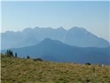
Begunjščica is a mountain range in the Karawanks east of Stol. Its highest peak is Veliki Vrh, which at over 2,000 m offers a fine view across ce...
4 h 20 min |
 | Podljubelj - Veliki vrh (Košuta) (via Matizovec)
Veliki Vrh, at 2,088 m, is the westernmost two-thousander in Slovenia's longest ridge, the Košuta. From the summit, which has a registration box ...
4 h 15 min |
 | Krnica - Debela peč
Debela peč is a 2014 m high mountain that rises steeply above the Krma valley on one side and gently descends towards the expansive Pokljuka fore...
5 h 30 min |
 | Polje - Črna prst
On the northern slope of the summit ridge of Črna prst, black soil is visible the feature after which the mountain is named. Črna prst is renown...
3 h 45 min |
 | Polje - Črna prst (via Orožnova koča)
On the northern slope of the summit ridge of Črna prst, black soil is visible the feature after which the mountain is named. Črna prst is renown...
4 h |
 | Podbrdo - Črna prst (via Vrh Bače)
On the northern slope of the summit ridge of Črna prst, black soil is visible the feature after which the mountain is named. Črna prst is renown...
5 h 25 min |
 | Bohinjska Bistrica - Črna prst (via Orožnova koča)
On the northern slope of the summit ridge of Črna prst, black soil is visible the feature after which the mountain is named. Črna prst is renown...
3 h 40 min |
| Bohinjska Bistrica - Črna prst (via Planina za Črno goro)
On the northern slope of the summit ridge of Črna prst, black soil is visible the feature after which the mountain is named. Črna prst is renown...
4 h |
 | Golnik - Tolsti vrh (via Kriška goro)
Tolsti vrh, located west of Storžič, is at 1715 metres also the highest peak of the Kriška gora range, which rises steeply above central Gorenjsk...
3 h 30 min |
 | Križe - Tolsti vrh (steep path over Kriška gora)
Tolsti vrh, located west of Storžič, is at 1715 metres also the highest peak of the Kriška gora range, which rises steeply above central Gorenjsk...
3 h 40 min |
| Križe - Tolsti vrh (easier path over Kriška gora)
Tolsti vrh, located west of Storžič, is at 1715 metres also the highest peak of the Kriška gora range, which rises steeply above central Gorenjsk...
3 h 45 min |
 | Križe - Tolsti vrh (via Ježa)
Tolsti vrh, located west of Storžič, is at 1715 metres also the highest peak of the Kriška gora range, which rises steeply above central Gorenjsk...
3 h 30 min |
 | Luče - Velika Raduha
Velika Raduha, at 2062 m, is the highest peak of the Raduha range, which rises steeply east of Robanov Kot. From the summit, with its registratio...
4 h 40 min |
 | Zadnjica - Pogačnikov dom na Kriških podih
The hut is located on the scenic ridge Griva on Kriški Podi above Trenta. The hut, open during the summer season, also has a large winter room. T...
4 h |
 | Zadnjica - Zasavska koča na Prehodavcih
The Zasavska koča na Prehodavcih mountain hut is located on a panoramic rise above the Valley of the Triglav Lakes. From the hut, open in the sum...
4 h 15 min |
| Trenta - Zasavska koča na Prehodavcih
The Zasavska koča na Prehodavcih mountain hut is located on a panoramic rise above the Valley of the Triglav Lakes. From the hut, open in the sum...
4 h 15 min |
 | Podbrdo - Možic (via Lajnar)
Možic is a 1,602 m high peak located west of Soriška Planina. At the very summit there is an old military bunker bearing the name of the peak and...
3 h 25 min |
 | Podbrdo - Porezen
Porezen is a 1,630 m high mountain situated between Davča and Baška Grapa. From the summit, where a large Partisan monument stands, a beautiful v...
3 h 30 min |
| Podbrdo - Porezen (via Dom na Poreznu)
Porezen is a 1,630 m high mountain situated between Davča and Baška Grapa. From the summit, where a large Partisan monument stands, a beautiful v...
3 h 35 min |
 | Dolenji Novaki - Porezen
Porezen is a 1,630 m high mountain situated between Davča and Baška Grapa. From the summit, where a large Partisan monument stands, a beautiful v...
4 h |
| Poče - Porezen (winter way)
Porezen is a 1,630 m high mountain situated between Davča and Baška Grapa. From the summit, where a large Partisan monument stands, a beautiful v...
3 h 25 min |
 | Mače - Srednji vrh (via Kozjek and Dolga njiva)
Srednji vrh is an 1853 m high mountain located east of Storžič. From the summit, which features a bench, registration box and stamp, there is a b...
3 h 35 min |
| Mače - Srednji vrh (Mačenska pot and via Cjanovca)
Srednji vrh is an 1853 m high mountain located east of Storžič. From the summit, which features a bench, registration box and stamp, there is a b...
3 h 55 min |
| Mače - Srednji vrh (Mačenska pot and via Dolga njiva)
Srednji vrh is an 1853 m high mountain located east of Storžič. From the summit, which features a bench, registration box and stamp, there is a b...
3 h 40 min |
| Mače - Srednji vrh (via Kozjek and Cjanovca)
Srednji vrh is an 1853 m high mountain located east of Storžič. From the summit, which features a bench, registration box and stamp, there is a b...
4 h 10 min |
 | Stara Fužina - Pršivec (Direct way)
Pršivec is a panoramic mountain above Lake Bohinj. The view is extensive in all directions: Triglav and the surrounding mountains are clearly vis...
3 h 45 min |
 | Kraljev hrib - Konj
Konj is an 1803 m high peak located between Velika Planina and Presedljaj. From the summit there is a beautiful view of the highest peaks of the ...
3 h 30 min |
 | Ribčev Laz - Rodica (via Čez Suho)
The mountain Rodica is located above Bohinj in the Lower Bohinj Mountains. From the summit there is a beautiful view over the Julian Alps and the...
4 h 15 min |
 | Koča pri Savici - Lanževica (via Bogatinsko sedlo)
Lanževica is a 2003 m high peak located between Bogatinsko sedlo and Oslova škrbina. From the summit, where remnants of the former Rapallo border...
5 h |
| Koča pri Savici - Lanževica (via Lepa Komna)
Lanževica is a 2003 m high peak located between Bogatinsko sedlo and Oslova škrbina. From the summit, where remnants of the former Rapallo border...
5 h |
 | Koča pri Savici - Mahavšček (via planina Govnjač)
Mahavšček, or Veliki Bogatin, is a 2008 m high mountain on the northwestern edge of the Lower Bohinj Mountains. From the summit, with its somewha...
4 h 55 min |
 | Mojstrana - Sleme
The mountain is located between Mojstrana and Kukova špica. The summit is grassy and offers a very beautiful view towards Kukova špica. There is ...
4 h 15 min |
 | Tržič - Bela peč (via Potarje and Spodnja Konjščica)
The mountain, known mainly among climbers, is located north of Storžič on the slopes of Konjščica. From the summit there is a beautiful view of t...
3 h 55 min |
 | Mače - Mali Grintovec (via Bašeljski vrh)
Mali Grintovec is a panoramic mountain located east of Storžič. From the summit, which has a summit register box, stamp, and a pleasant bench, th...
4 h |
| Mače - Mali Grintovec (via Kozjek and Dolga njiva)
Mali Grintovec is a panoramic mountain located east of Storžič. From the summit, which has a summit register box, stamp, and a pleasant bench, th...
3 h 35 min |
| Mače - Mali Grintovec (Mačenska pot and via Dolga njiva)
Mali Grintovec is a panoramic mountain located east of Storžič. From the summit, which has a summit register box, stamp, and a pleasant bench, th...
3 h 40 min |
| Bašelj - Mali Grintovec (via Bašeljski vrh)
Mali Grintovec is a panoramic mountain located east of Storžič. From the summit, which has a summit register box, stamp, and a pleasant bench, th...
4 h |
| Bašelj - Mali Grintovec (via hospital Košuta and over Bašeljski vrh)
Mali Grintovec is a panoramic mountain located east of Storžič. From the summit, which has a summit register box, stamp, and a pleasant bench, th...
4 h 10 min |
 | Mače - Mali Grintovec (via Dom na Kališču)
Mali Grintovec is a panoramic mountain located east of Storžič. From the summit, which has a summit register box, stamp, and a pleasant bench, th...
3 h 50 min |
| Bašelj - Mali Grintovec (via Dom na Kališču)
Mali Grintovec is a panoramic mountain located east of Storžič. From the summit, which has a summit register box, stamp, and a pleasant bench, th...
3 h 50 min |
| Bašelj - Mali Grintovec (via hospital Košuta and Dom na Kališču)
Mali Grintovec is a panoramic mountain located east of Storžič. From the summit, which has a summit register box, stamp, and a pleasant bench, th...
4 h |
 | Rosenbach - Rosenkogel/Hruški vrh
Hruški vrh is a 1776-metre-high mountain located between Dovška Baba and the lesser-known Klek. From the summit, where there is a small chapel de...
3 h 50 min |
 | Rosenbach - Rosenkogel/Hruški vrh (via Koprivnjak)
Hruški vrh is a 1776-metre-high mountain located between Dovška Baba and the lesser-known Klek. From the summit, where there is a small chapel de...
4 h |
 | Gornji Grad - Vivodnik (via Semprimožnik and Ovčji stan)
Vivodnik, at 1508 meters, is the highest peak of Menina planina, a plateau rising south of Gornji Grad. From the summit, which has a small observ...
3 h 30 min |
 | Tirosek (Nova Štifta) - Vivodnik
Vivodnik, at 1508 meters, is the highest peak of Menina planina, a plateau rising south of Gornji Grad. From the summit, which has a small observ...
4 h |
| Hruševka - Vivodnik
Vivodnik, at 1508 meters, is the highest peak of Menina planina, a plateau rising south of Gornji Grad. From the summit, which has a small observ...
5 h 30 min |
 | Gornji Grad - Vivodnik (past Strmčnik and cave Jespa)
Vivodnik, at 1508 meters, is the highest peak of Menina planina, a plateau rising south of Gornji Grad. From the summit, which has a small observ...
3 h 30 min |
| Gornji Grad - Vivodnik (via Borovnica and cave Jespa)
Vivodnik, at 1508 meters, is the highest peak of Menina planina, a plateau rising south of Gornji Grad. From the summit, which has a small observ...
3 h 25 min |
| Gornji Grad - Vivodnik (past Semprimožnik and cave Jespa)
Vivodnik, at 1508 meters, is the highest peak of Menina planina, a plateau rising south of Gornji Grad. From the summit, which has a small observ...
3 h 40 min |
 | Ukanc - Šija (via planina Zadnji Vogel)
Šija is located above the Vogel ski resort in the Lower Bohinj Mountains. From the summit, there is a nice view of the neighboring peaks in the s...
4 h 25 min |
 | Ukanc - Šija (via Žagarjev graben)
Šija is located above the Vogel ski resort in the Lower Bohinj Mountains. From the summit, there is a nice view of the neighboring peaks in the s...
4 h |
 | Mojstrana - Vrtaški vrh
Vrtaški Vrh is a panoramic mountain above Vrata Valley. From the grassy peak, surrounded by dwarf pines, there is a nice view toward the neighbor...
3 h 40 min |
 | Poljana (Završnica) - Potoški Stol (Žirovniška pot)
Potoški Stol is located between Stol and Vajnež on the border with Austria. A cross stands just a few metres below the grassy summit. The finest ...
4 h 25 min |
 | Ljubno ob Savinji - Veliki Travnik (Turnovka)
Veliki Travnik, also known as Turnovka by the locals, is located on the western edge of the Smrekovec mountain range. From the summit, which has ...
4 h |
 | Mače - Cjanovca (Mačenska pot and on SE ridge)
Cjanovca is a peak east of Storžič and south of Srednji vrh. It is clearly visible from Kranj and its surroundings. The southern slope is bare, w...
3 h 40 min |
| Mače - Cjanovca (over Kozjek and on SE ridge)
Cjanovca is a peak east of Storžič and south of Srednji vrh. It is clearly visible from Kranj and its surroundings. The southern slope is bare, w...
3 h 55 min |
| Mače - Cjanovca (Mačenska pot and via Dolga njiva)
Cjanovca is a peak east of Storžič and south of Srednji vrh. It is clearly visible from Kranj and its surroundings. The southern slope is bare, w...
3 h 35 min |
| Mače - Cjanovca (via Kozjek and Dolga njiva)
Cjanovca is a peak east of Storžič and south of Srednji vrh. It is clearly visible from Kranj and its surroundings. The southern slope is bare, w...
3 h 30 min |
 | Vitanje - Rogla
Rogla is a peak in the middle of the eponymous ski resort. The peak is forested with a small clearing on which stands a lookout tower. The tower ...
4 h |
 | Mislinja - Rogla (via Tolsti Vrh)
Rogla is a peak in the middle of the eponymous ski resort. The peak is forested with a small clearing on which stands a lookout tower. The tower ...
4 h 15 min |
 | Zreče (church of St. Egidij) - Rogla (via Gorenje)
Rogla is a peak in the middle of the eponymous ski resort. The peak is forested with a small clearing on which stands a lookout tower. The tower ...
3 h 50 min |
 | Lovrenc na Pohorju - Rogla
Rogla is a peak in the middle of the eponymous ski resort. The peak is forested with a small clearing on which stands a lookout tower. The tower ...
4 h 30 min |
 | Lovrenc na Pohorju - Lovrenška jezera
The Lovrenška jezera are located on a high bog in the middle of Pohorje between Rogla and Ribniško Pohorje. The smaller lakes, which receive wate...
3 h 35 min |
 | Lovrenc na Pohorju (cemetery) - Jezerski vrh
Jezerski vrh is located on Ribniško Pohorje near the Ribniška koča mountain hut. Due to the unvegetated peak, there is a nice view of Pohorje and...
4 h 20 min |
 | Dovže - Črni vrh
Črni vrh is the highest peak of Pohorje. Because it is partly unvegetated, it offers a nice view toward Velika Kopa, Uršlja gora, and in the back...
3 h 45 min |
 | Ukanc - Vogel (via planina Zadnji Vogel)
Many associate the name Vogel first with the Vogel ski resort near the eponymous peak. From the north, it is recognizable by its pyramidal shape,...
4 h 30 min |
 | Ukanc - Vogel (via Globoko)
Many associate the name Vogel first with the Vogel ski resort near the eponymous peak. From the north, it is recognizable by its pyramidal shape,...
4 h 15 min |
 | Mežica - Uršlja gora (Plešivec) (via Sveti Lenart and Koča na Naravskih ledinah)
Uršlja gora, or Plešivec, is a panoramic mountain between Slovenj Gradec and Črna na Koroškem. At or just below the summit stands the Church of S...
5 h 30 min |
 | Mežica - Uršlja gora (Plešivec) (via Sveti Lenart and over Kozji hrbet)
Uršlja gora, or Plešivec, is a panoramic mountain between Slovenj Gradec and Črna na Koroškem. At or just below the summit stands the Church of S...
5 h 15 min |
| Leše - Uršlja gora (Plešivec) (via Koča na Naravskih ledinah)
Uršlja gora, or Plešivec, is a panoramic mountain between Slovenj Gradec and Črna na Koroškem. At or just below the summit stands the Church of S...
4 h 25 min |
 | Učja - Monte Guarda/Skutnik
Skutnik is a peak situated north of the Učja River on the border with Italy. From the top, there is a beautiful view of the Kanin mountain group,...
3 h 45 min |
 | Podpeca (Helenski potok) - Mala Peca (via Mirjanca)
Mala Peca is the peak above the Dom na Peci mountain hut on its eastern slopes. From the summit, where a panoramic sign stands, there is a nice v...
3 h 20 min |
 | Waidisch / Bajdiše - Ferlacher Horn / Grlovec
Grlovec/Ferlacher Horn is a panoramic mountain on which a large cross stands. From the top, there is a beautiful view of the Karawanks, parts of ...
3 h 35 min |
 | Bistriški jarek (border crossing Muta) - Huhnerkogel/Košenjak (via Bivak Piramida)
Košenjak is located north of Dravograd and the Drava River on the border with neighbouring Austria. Access to Košenjak is possible on foot or by ...
4 h 50 min |
| Bistriški jarek (border crossing Muta) - Huhnerkogel/Košenjak (via Sveti Urban)
Košenjak is located north of Dravograd and the Drava River on the border with neighbouring Austria. Access to Košenjak is possible on foot or by ...
4 h 35 min |
| Bistriški jarek (Glasbeni dom) - Huhnerkogel/Košenjak (via Bivak Piramida)
Košenjak is located north of Dravograd and the Drava River on the border with neighbouring Austria. Access to Košenjak is possible on foot or by ...
4 h 45 min |
| Bistriški jarek (Glasbeni dom) - Huhnerkogel/Košenjak (via Sveti Urban)
Košenjak is located north of Dravograd and the Drava River on the border with neighbouring Austria. Access to Košenjak is possible on foot or by ...
4 h 30 min |
| Muta (Zgornja Muta) - Huhnerkogel/Košenjak (past Bivouac Piramida)
Košenjak is located north of Dravograd and the Drava River on the border with neighbouring Austria. Access to Košenjak is possible on foot or by ...
5 h 45 min |
| Muta (Zgornja Muta) - Huhnerkogel/Košenjak (past Sveti Urban)
Košenjak is located north of Dravograd and the Drava River on the border with neighbouring Austria. Access to Košenjak is possible on foot or by ...
5 h 30 min |
 | Trnje / Dornach - Singerberg / Žingarica
Žingarica / Singerberg is a peak on the Austrian side of the Karawanks above the village of Slovenji Plajberk / Windisch Bleiberg. From the summi...
3 h 20 min |
 | Bistrica v Rožu / Feistritz im Rosental - Singerberg / Žingarica
Žingarica / Singerberg is a peak on the Austrian side of the Karawanks above the village of Slovenji Plajberk / Windisch Bleiberg. From the summi...
3 h 55 min |
 | Glavaš - Dinara (past Martinova Košara and on western path)
Vrh Sinjal or Dinara (1831 m) is the highest peak in Croatia. From the summit, where there is a summit register and a cross, there is a nice view...
4 h 30 min |
| Glavaš - Dinara (past cotage Drago Grubać)
Vrh Sinjal or Dinara (1831 m) is the highest peak in Croatia. From the summit, where there is a summit register and a cross, there is a nice view...
4 h |
 | Žekovec - Boskovec (past Keber and Mozirska koča)
Boskovec is with 1587 m the highest peak of the Golte plateau. From the top on which a lookout tower stands, a view opens up on part of Kamnik Sa...
3 h 20 min |
 | Rosenbach - Kleiner Frauenkogel/Koprivnjak
Koprivnjak (Mala Dovška Baba) is a 1754 m high peak on the Austrian side of the Karawanks. From the summit, where a cross and summit logbook stan...
3 h 30 min |
 | Podkraj / Unterort - Wackendorfer Spitze
Veška kopa, also known as Veški vrh or by its German name Wackendorfer Spitze, is the northernmost two-thousander in the Peca range. From its ind...
5 h |
 | Globasnitz - Wackendorfer Spitze
Veška kopa, also known as Veški vrh or by its German name Wackendorfer Spitze, is the northernmost two-thousander in the Peca range. From its ind...
4 h 35 min |
 | Podkraj / Unterort - Wackendorfer Spitze (on path P7)
Veška kopa, also known as Veški vrh or by its German name Wackendorfer Spitze, is the northernmost two-thousander in the Peca range. From its ind...
5 h 5 min |
 | Podrošt - Altemaver (Ratitovec)
Altemaver (Ratitovec), at 1,678 meters, is the highest peak of Ratitovec. From its grassy summit, there is a beautiful view of the Julian Alps, J...
3 h 20 min |
 | Koča pri Savici - Kser
Kser is a less prominent peak in the ridge of the Spodnje Bohinjske gore, more precisely between Tolminski Kuk and Mahavšček. From the summit, wh...
4 h 30 min |
 | Susalitch - Zajčnik
Zajčnik (also Blekova) is a 1746-meter-high peak situated northeast of Vošca. From the partly vegetated summit, which borders Slovenia and Austri...
3 h 35 min |
| Korpitch - Zajčnik
Zajčnik (also Blekova) is a 1746-meter-high peak situated northeast of Vošca. From the partly vegetated summit, which borders Slovenia and Austri...
3 h 35 min |
 | Podkanja vas / Wildenstein - Kraguljše
Kraguljše is an 1828 m high peak situated in the Obir mountain range. From its spacious summit, which has a small wooden bench, beautiful views o...
4 h 10 min |
 | Ukanc - Visoki Orlov rob (via Žagarjev graben)
Visoki Orlov rob is a 1,800-meter-high peak located right next to the upper station of the Šija single-chair lift. From the summit, which lies sl...
3 h 45 min |
 | Podbrdo - Slatnik (southeastern peak)
Slatnik (southeastern peak) is a panoramic mountain that rises steeply above Baška grapa on one side and descends more gently toward Soriška plan...
3 h 25 min |
 | Mislinja - Ostruščica (via Tolsti Vrh)
Ostruščica is a 1,498-meter-high peak located west of the ski slopes on Rogla....
4 h 15 min |
 | Podrožca / Rosenbach - Kamnica (Komnica) / Ferlacher Spitze
Kamnica is a panoramic mountain on the Austrian side of the Karawanks, more precisely north of Kepa. From the summit, which has a cross, summit r...
3 h 55 min |
 | Lovrenc na Pohorju - Pesek
Pesek is a 1,423-meter-high peak on Pohorje, located above Koča na Pesku....
4 h 8 min |
 | Kosmadei - Vigla (Kerkis) (Samos) (no. 11 / 10)
Vigla is at 1,443 m the highest peak of Mount Kerkis on the Greek island of Samos.There are several interesting spots on and near the mountain of...
4 h 15 min |
 | Kosmadei - Vigla (Kerkis) (Samos) (no. 9 / 10)
Vigla is at 1,443 m the highest peak of Mount Kerkis on the Greek island of Samos.There are several interesting spots on and near the mountain of...
5 h |