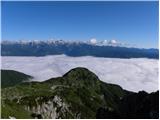
 | Podbrdo - Črna prst
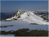
On the northern slope of the summit ridge of Črna prst, black soil is visible the feature after which the mountain is named. Črna prst is renown...
3 h 15 min |
 | Polje - Črna prst
On the northern slope of the summit ridge of Črna prst, black soil is visible the feature after which the mountain is named. Črna prst is renown...
3 h 45 min |
 | Polje - Črna prst (via Orožnova koča)
On the northern slope of the summit ridge of Črna prst, black soil is visible the feature after which the mountain is named. Črna prst is renown...
4 h |
 | Bohinjska Bistrica - Črna prst (via Orožnova koča)
On the northern slope of the summit ridge of Črna prst, black soil is visible the feature after which the mountain is named. Črna prst is renown...
3 h 40 min |
| Bohinjska Bistrica - Črna prst (via Planina za Črno goro)
On the northern slope of the summit ridge of Črna prst, black soil is visible the feature after which the mountain is named. Črna prst is renown...
4 h |
 | Zalog - Tolsti vrh
Tolsti vrh, located west of Storžič, is at 1715 metres also the highest peak of the Kriška gora range, which rises steeply above central Gorenjsk...
3 h 5 min |
 | Tržič - Tolsti vrh
Tolsti vrh, located west of Storžič, is at 1715 metres also the highest peak of the Kriška gora range, which rises steeply above central Gorenjsk...
3 h 15 min |
 | Golnik - Tolsti vrh (via Kriška goro)
Tolsti vrh, located west of Storžič, is at 1715 metres also the highest peak of the Kriška gora range, which rises steeply above central Gorenjsk...
3 h 30 min |
 | Golnik - Tolsti vrh (via Ježa)
Tolsti vrh, located west of Storžič, is at 1715 metres also the highest peak of the Kriška gora range, which rises steeply above central Gorenjsk...
3 h 15 min |
 | Križe - Tolsti vrh (steep path over Kriška gora)
Tolsti vrh, located west of Storžič, is at 1715 metres also the highest peak of the Kriška gora range, which rises steeply above central Gorenjsk...
3 h 40 min |
| Križe - Tolsti vrh (easier path over Kriška gora)
Tolsti vrh, located west of Storžič, is at 1715 metres also the highest peak of the Kriška gora range, which rises steeply above central Gorenjsk...
3 h 45 min |
| Križe - Tolsti vrh (via Ježa)
Tolsti vrh, located west of Storžič, is at 1715 metres also the highest peak of the Kriška gora range, which rises steeply above central Gorenjsk...
3 h 30 min |
 | Tržič - Dobrča
Dobrča is a 1634-metre mountain located between Begunje and Tržič. From the summit, which has a registration box with a stamp, the view opens onl...
3 h 10 min |
 | Zali Log - Blegoš (via Potok)
Blegoš is a 1,562-metre-high mountain located between the Selška Sora and Poljanska Sora rivers. From the grassy summit, where there is a stamp a...
3 h |
 | Podbrdo - Možic
Možic is a 1,602 m high peak located west of Soriška Planina. At the very summit there is an old military bunker bearing the name of the peak and...
3 h 15 min |
| Podbrdo - Možic (via Lajnar)
Možic is a 1,602 m high peak located west of Soriška Planina. At the very summit there is an old military bunker bearing the name of the peak and...
3 h 25 min |
 | Hudajužna - Porezen
Porezen is a 1,630 m high mountain situated between Davča and Baška Grapa. From the summit, where a large Partisan monument stands, a beautiful v...
3 h 15 min |
 | Podbrdo - Porezen
Porezen is a 1,630 m high mountain situated between Davča and Baška Grapa. From the summit, where a large Partisan monument stands, a beautiful v...
3 h 30 min |
| Podbrdo - Porezen (via Dom na Poreznu)
Porezen is a 1,630 m high mountain situated between Davča and Baška Grapa. From the summit, where a large Partisan monument stands, a beautiful v...
3 h 35 min |
 | Dolenji Novaki - Porezen
Porezen is a 1,630 m high mountain situated between Davča and Baška Grapa. From the summit, where a large Partisan monument stands, a beautiful v...
4 h |
 | Mače - Srednji vrh (via Kozjek and Dolga njiva)
Srednji vrh is an 1853 m high mountain located east of Storžič. From the summit, which features a bench, registration box and stamp, there is a b...
3 h 35 min |
| Spodnja Kokra - Srednji vrh
Srednji vrh is an 1853 m high mountain located east of Storžič. From the summit, which features a bench, registration box and stamp, there is a b...
4 h 5 min |
| Mače - Srednji vrh (Mačenska pot and via Cjanovca)
Srednji vrh is an 1853 m high mountain located east of Storžič. From the summit, which features a bench, registration box and stamp, there is a b...
3 h 55 min |
| Mače - Srednji vrh (Mačenska pot and via Dolga njiva)
Srednji vrh is an 1853 m high mountain located east of Storžič. From the summit, which features a bench, registration box and stamp, there is a b...
3 h 40 min |
| Mače - Srednji vrh (via Kozjek and Cjanovca)
Srednji vrh is an 1853 m high mountain located east of Storžič. From the summit, which features a bench, registration box and stamp, there is a b...
4 h 10 min |
 | Stara Fužina - Pršivec (Direct way)
Pršivec is a panoramic mountain above Lake Bohinj. The view is extensive in all directions: Triglav and the surrounding mountains are clearly vis...
3 h 45 min |
 | Mače - Javorov vrh (Mačenska pot)
Javorov Vrh (recorded in some sources as Javorjev Vrh) is a 1,434 m high mountain northeast of Preddvor. The summit, with its registration box an...
2 h 55 min |
| Mače - Javorov vrh (via Kozjek)
Javorov Vrh (recorded in some sources as Javorjev Vrh) is a 1,434 m high mountain northeast of Preddvor. The summit, with its registration box an...
3 h 10 min |
 | Mače - Bašeljski vrh
Bašeljski vrh is a 1744-meter-high mountain located between Mali Grintovec and Storžič. From the summit, where there is a bench and a registratio...
3 h 15 min |
| Bašelj - Bašeljski vrh (via hospital Košuta)
Bašeljski vrh is a 1744-meter-high mountain located between Mali Grintovec and Storžič. From the summit, where there is a bench and a registratio...
3 h 25 min |
| Bašelj - Bašeljski vrh
Bašeljski vrh is a 1744-meter-high mountain located between Mali Grintovec and Storžič. From the summit, where there is a bench and a registratio...
3 h 15 min |
| Mače - Bašeljski vrh (via Kozjek)
Bašeljski vrh is a 1744-meter-high mountain located between Mali Grintovec and Storžič. From the summit, where there is a bench and a registratio...
3 h 30 min |
| Spodnja Kokra - Bašeljski vrh
Bašeljski vrh is a 1744-meter-high mountain located between Mali Grintovec and Storžič. From the summit, where there is a bench and a registratio...
4 h 40 min |
 | Kraljev hrib - Konj
Konj is an 1803 m high peak located between Velika Planina and Presedljaj. From the summit there is a beautiful view of the highest peaks of the ...
3 h 30 min |
 | Podbrdo - Slatnik (northwestern peak)
Slatnik is a panoramic mountain located west of the Soriška Planina ski resort. From its grassy summit there is a beautiful view of the Škofjeloš...
3 h 15 min |
 | Podbrdo - Slatnik (northwestern peak) (via Lajnar)
Slatnik is a panoramic mountain located west of the Soriška Planina ski resort. From its grassy summit there is a beautiful view of the Škofjeloš...
3 h 10 min |
 | Tržič - Bela peč (via Potarje and Spodnja Konjščica)
The mountain, known mainly among climbers, is located north of Storžič on the slopes of Konjščica. From the summit there is a beautiful view of t...
3 h 55 min |
 | Gornji Grad - Lepenatka (via Kal)
Lepenatka is a grassy peak located south of the 1557-metre-high Rogatec. From the summit, which has a summit register box and stamp, there is a b...
3 h |
 | Gornji Grad - Lepenatka (on ridge)
Lepenatka is a grassy peak located south of the 1557-metre-high Rogatec. From the summit, which has a summit register box and stamp, there is a b...
3 h |
 | Mače - Mali Grintovec (via Bašeljski vrh)
Mali Grintovec is a panoramic mountain located east of Storžič. From the summit, which has a summit register box, stamp, and a pleasant bench, th...
4 h |
| Mače - Mali Grintovec (via Kozjek and Dolga njiva)
Mali Grintovec is a panoramic mountain located east of Storžič. From the summit, which has a summit register box, stamp, and a pleasant bench, th...
3 h 35 min |
| Mače - Mali Grintovec (Mačenska pot and via Dolga njiva)
Mali Grintovec is a panoramic mountain located east of Storžič. From the summit, which has a summit register box, stamp, and a pleasant bench, th...
3 h 40 min |
| Bašelj - Mali Grintovec (via Bašeljski vrh)
Mali Grintovec is a panoramic mountain located east of Storžič. From the summit, which has a summit register box, stamp, and a pleasant bench, th...
4 h |
| Bašelj - Mali Grintovec (via hospital Košuta and over Bašeljski vrh)
Mali Grintovec is a panoramic mountain located east of Storžič. From the summit, which has a summit register box, stamp, and a pleasant bench, th...
4 h 10 min |
| Spodnja Kokra - Mali Grintovec
Mali Grintovec is a panoramic mountain located east of Storžič. From the summit, which has a summit register box, stamp, and a pleasant bench, th...
4 h 45 min |
 | Mače - Mali Grintovec (via Dom na Kališču)
Mali Grintovec is a panoramic mountain located east of Storžič. From the summit, which has a summit register box, stamp, and a pleasant bench, th...
3 h 50 min |
| Bašelj - Mali Grintovec (via Dom na Kališču)
Mali Grintovec is a panoramic mountain located east of Storžič. From the summit, which has a summit register box, stamp, and a pleasant bench, th...
3 h 50 min |
| Bašelj - Mali Grintovec (via hospital Košuta and Dom na Kališču)
Mali Grintovec is a panoramic mountain located east of Storžič. From the summit, which has a summit register box, stamp, and a pleasant bench, th...
4 h |
 | Podbrdo - Kobla
The summit is located in the Lower Bohinj Mountains between Črna prst and Soriška planina. Directly below it is a railway tunnel connecting Bohin...
3 h |
 | Podbrdo - Lajnar
Lajnar is a 1,549-metre-high mountain located north of Soriška Planina. From the summit, which is also the highest point of the ski resort, a bea...
2 h 55 min |
 | Podbrdo - Šavnik
Šavnik is a grassy peak situated between the ski resorts of Soriška Planina and Kobla. From the summit, which has a registration box with a stamp...
3 h |
 | Gornji Grad - Vivodnik (via Semprimožnik and Ovčji stan)
Vivodnik, at 1508 meters, is the highest peak of Menina planina, a plateau rising south of Gornji Grad. From the summit, which has a small observ...
3 h 30 min |
 | Tirosek (Nova Štifta) - Vivodnik
Vivodnik, at 1508 meters, is the highest peak of Menina planina, a plateau rising south of Gornji Grad. From the summit, which has a small observ...
4 h |
 | Gornji Grad - Vivodnik (past Strmčnik and cave Jespa)
Vivodnik, at 1508 meters, is the highest peak of Menina planina, a plateau rising south of Gornji Grad. From the summit, which has a small observ...
3 h 30 min |
| Gornji Grad - Vivodnik (via Borovnica and Ovčji stan)
Vivodnik, at 1508 meters, is the highest peak of Menina planina, a plateau rising south of Gornji Grad. From the summit, which has a small observ...
3 h 15 min |
| Gornji Grad - Vivodnik (via Borovnica and cave Jespa)
Vivodnik, at 1508 meters, is the highest peak of Menina planina, a plateau rising south of Gornji Grad. From the summit, which has a small observ...
3 h 25 min |
| Gornji Grad - Vivodnik (past Semprimožnik and cave Jespa)
Vivodnik, at 1508 meters, is the highest peak of Menina planina, a plateau rising south of Gornji Grad. From the summit, which has a small observ...
3 h 40 min |
 | Ukanc - Šija (via planina Zadnji Vogel)
Šija is located above the Vogel ski resort in the Lower Bohinj Mountains. From the summit, there is a nice view of the neighboring peaks in the s...
4 h 25 min |
 | Ukanc - Šija (via Žagarjev graben)
Šija is located above the Vogel ski resort in the Lower Bohinj Mountains. From the summit, there is a nice view of the neighboring peaks in the s...
4 h |
 | Ljubenske Rastke - Komen
At 1684 meters, Komen is the highest peak in the Smrekovec mountain range, which borders between Styria and Carinthia. In good weather, the summi...
3 h 15 min |
 | Spodnja Kokra - Cjanovca
Cjanovca is a peak east of Storžič and south of Srednji vrh. It is clearly visible from Kranj and its surroundings. The southern slope is bare, w...
3 h 50 min |
| Mače - Cjanovca (Mačenska pot and on SE ridge)
Cjanovca is a peak east of Storžič and south of Srednji vrh. It is clearly visible from Kranj and its surroundings. The southern slope is bare, w...
3 h 40 min |
| Mače - Cjanovca (over Kozjek and on SE ridge)
Cjanovca is a peak east of Storžič and south of Srednji vrh. It is clearly visible from Kranj and its surroundings. The southern slope is bare, w...
3 h 55 min |
| Mače - Cjanovca (Mačenska pot and via Dolga njiva)
Cjanovca is a peak east of Storžič and south of Srednji vrh. It is clearly visible from Kranj and its surroundings. The southern slope is bare, w...
3 h 35 min |
| Mače - Cjanovca (via Kozjek and Dolga njiva)
Cjanovca is a peak east of Storžič and south of Srednji vrh. It is clearly visible from Kranj and its surroundings. The southern slope is bare, w...
3 h 30 min |
 | Vrtovin - Veliki Modrasovec
Veliki Modrasovec is located on the southern part of the Trnovski Forest near Predmeja. On the summit stands an old military building, which we m...
3 h 15 min |
 | Vitanje - Rogla
Rogla is a peak in the middle of the eponymous ski resort. The peak is forested with a small clearing on which stands a lookout tower. The tower ...
4 h |
 | Mislinja - Rogla (via Tolsti Vrh)
Rogla is a peak in the middle of the eponymous ski resort. The peak is forested with a small clearing on which stands a lookout tower. The tower ...
4 h 15 min |
 | Zreče (church of St. Egidij) - Rogla (via Gorenje)
Rogla is a peak in the middle of the eponymous ski resort. The peak is forested with a small clearing on which stands a lookout tower. The tower ...
3 h 50 min |
 | Lovrenc na Pohorju - Rogla
Rogla is a peak in the middle of the eponymous ski resort. The peak is forested with a small clearing on which stands a lookout tower. The tower ...
4 h 30 min |
 | Oplotnica - Rogla
Rogla is a peak in the middle of the eponymous ski resort. The peak is forested with a small clearing on which stands a lookout tower. The tower ...
4 h 20 min |
 | Lovrenc na Pohorju - Lovrenška jezera
The Lovrenška jezera are located on a high bog in the middle of Pohorje between Rogla and Ribniško Pohorje. The smaller lakes, which receive wate...
3 h 35 min |
 | Lovrenc na Pohorju (cemetery) - Jezerski vrh
Jezerski vrh is located on Ribniško Pohorje near the Ribniška koča mountain hut. Due to the unvegetated peak, there is a nice view of Pohorje and...
4 h 20 min |
 | Dovže - Črni vrh
Črni vrh is the highest peak of Pohorje. Because it is partly unvegetated, it offers a nice view toward Velika Kopa, Uršlja gora, and in the back...
3 h 45 min |
 | Dovže - Velika Kopa
Velika Kopa is a 1542-meter-high peak located between Grmovškov dom and the nearby Mala Kopa. From the top, which is only 1 meter lower than the ...
3 h 15 min |
 | Vuhred - Velika Kopa
Velika Kopa is a 1542-meter-high peak located between Grmovškov dom and the nearby Mala Kopa. From the top, which is only 1 meter lower than the ...
5 h 5 min |
 | Ukanc - Vogel (via planina Zadnji Vogel)
Many associate the name Vogel first with the Vogel ski resort near the eponymous peak. From the north, it is recognizable by its pyramidal shape,...
4 h 30 min |
 | Ukanc - Vogel (via Globoko)
Many associate the name Vogel first with the Vogel ski resort near the eponymous peak. From the north, it is recognizable by its pyramidal shape,...
4 h 15 min |
 | Žerjav - Uršlja gora (Plešivec)
Uršlja gora, or Plešivec, is a panoramic mountain between Slovenj Gradec and Črna na Koroškem. At or just below the summit stands the Church of S...
3 h 15 min |
 | Leše - Uršlja gora (Plešivec) (via Koča na Naravskih ledinah)
Uršlja gora, or Plešivec, is a panoramic mountain between Slovenj Gradec and Črna na Koroškem. At or just below the summit stands the Church of S...
4 h 25 min |
 | Waidisch / Bajdiše - Ferlacher Horn / Grlovec
Grlovec/Ferlacher Horn is a panoramic mountain on which a large cross stands. From the top, there is a beautiful view of the Karawanks, parts of ...
3 h 35 min |
 | Podbrdo - Krevl
Krevl is a 1515-meter-high peak situated south of the Kobla ski area, more precisely between the Kobla peak and Kravja Črna gora. From the summit...
3 h 15 min |
 | Bohinjska Bistrica - Krevl (via Planina za Črno goro)
Krevl is a 1515-meter-high peak situated south of the Kobla ski area, more precisely between the Kobla peak and Kravja Črna gora. From the summit...
2 h 55 min |
 | Dravograd - Huhnerkogel/Košenjak (via Ojstrica)
Košenjak is located north of Dravograd and the Drava River on the border with neighbouring Austria. Access to Košenjak is possible on foot or by ...
3 h 15 min |
 | Dravograd - Huhnerkogel/Košenjak (via Goriški Vrh)
Košenjak is located north of Dravograd and the Drava River on the border with neighbouring Austria. Access to Košenjak is possible on foot or by ...
3 h |
 | Lavamünd - Huhnerkogel/Košenjak
Košenjak is located north of Dravograd and the Drava River on the border with neighbouring Austria. Access to Košenjak is possible on foot or by ...
4 h |
 | Bistriški jarek (border crossing Muta) - Huhnerkogel/Košenjak (via Bivak Piramida)
Košenjak is located north of Dravograd and the Drava River on the border with neighbouring Austria. Access to Košenjak is possible on foot or by ...
4 h 50 min |
| Bistriški jarek (border crossing Muta) - Huhnerkogel/Košenjak (via Sveti Urban)
Košenjak is located north of Dravograd and the Drava River on the border with neighbouring Austria. Access to Košenjak is possible on foot or by ...
4 h 35 min |
| Bistriški jarek (Glasbeni dom) - Huhnerkogel/Košenjak (via Bivak Piramida)
Košenjak is located north of Dravograd and the Drava River on the border with neighbouring Austria. Access to Košenjak is possible on foot or by ...
4 h 45 min |
| Bistriški jarek (Glasbeni dom) - Huhnerkogel/Košenjak (via Sveti Urban)
Košenjak is located north of Dravograd and the Drava River on the border with neighbouring Austria. Access to Košenjak is possible on foot or by ...
4 h 30 min |
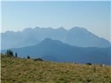
 | Potoki - Stol (Julian Alps)
Stol (1673 m) is located in the longest ridge of the Julian Alps. The ridge measures 25 km, or 35 km if including the western part. From the summ...
4 h |
 | Bistrica v Rožu / Feistritz im Rosental - Sinacher Gupf / Psinski vrh (west path)
Sinski vrh (mostly marked as Psinski vrh on maps) / Sinacher Gupf is a peak north of the main Karawanks ridge, more precisely north of Stol and V...
3 h 15 min |
| Bistrica v Rožu / Feistritz im Rosental - Sinacher Gupf / Psinski vrh (east path)
Sinski vrh (mostly marked as Psinski vrh on maps) / Sinacher Gupf is a peak north of the main Karawanks ridge, more precisely north of Stol and V...
3 h 15 min |
 | Trnje / Dornach - Singerberg / Žingarica
Žingarica / Singerberg is a peak on the Austrian side of the Karawanks above the village of Slovenji Plajberk / Windisch Bleiberg. From the summi...
3 h 20 min |
 | Bistrica v Rožu / Feistritz im Rosental - Singerberg / Žingarica
Žingarica / Singerberg is a peak on the Austrian side of the Karawanks above the village of Slovenji Plajberk / Windisch Bleiberg. From the summi...
3 h 55 min |
 | Log - Žigartov vrh
Žigartov vrh, at 1,346 meters, is the highest peak in the eastern part of Pohorje. An "observation" tower once stood on the summit, erected solel...
3 h 35 min |
| Pivola (Reka) - Žigartov vrh (via Petkovo sedlo)
Žigartov vrh, at 1,346 meters, is the highest peak in the eastern part of Pohorje. An "observation" tower once stood on the summit, erected solel...
3 h 55 min |
 | Tržič - Šentanski vrh
Šentanski vrh, located in the Dobrča range just five minutes from the main peak, offers a nice view of the central Karawanks, the Storžič group, ...
3 h 15 min |
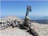
 | Glavaš - Dinara (past Martinova Košara and on western path)
Vrh Sinjal or Dinara (1831 m) is the highest peak in Croatia. From the summit, where there is a summit register and a cross, there is a nice view...
4 h 30 min |
| Glavaš - Dinara (past cotage Drago Grubać)
Vrh Sinjal or Dinara (1831 m) is the highest peak in Croatia. From the summit, where there is a summit register and a cross, there is a nice view...
4 h |
 | Žekovec - Boskovec (via Verbučeva planina)
Boskovec is with 1587 m the highest peak of the Golte plateau. From the top on which a lookout tower stands, a view opens up on part of Kamnik Sa...
3 h |
 | Žekovec - Boskovec (past Keber and Mozirska koča)
Boskovec is with 1587 m the highest peak of the Golte plateau. From the top on which a lookout tower stands, a view opens up on part of Kamnik Sa...
3 h 20 min |
 | Radegunda (Žekovec) - Boskovec (through Zagradiška puša and on path Severjeva pot)
Boskovec is with 1587 m the highest peak of the Golte plateau. From the top on which a lookout tower stands, a view opens up on part of Kamnik Sa...
3 h 10 min |
| Radegunda (Žekovec) - Boskovec (via Zagradiška puša and Hleviška planina)
Boskovec is with 1587 m the highest peak of the Golte plateau. From the top on which a lookout tower stands, a view opens up on part of Kamnik Sa...
3 h 15 min |
 | Lovrenc na Pohorju - Klopni vrh (via Spodnji trg and on northern path)
From the northwest, Klopni vrh closes off the lower-lying extensive plateau on eastern Pohorje. The horizontal cross-sectional area at 1300 m is ...
3 h 5 min |
| Lovrenc na Pohorju - Klopni vrh (via Spodnji trg and on eastern path)
From the northwest, Klopni vrh closes off the lower-lying extensive plateau on eastern Pohorje. The horizontal cross-sectional area at 1300 m is ...
3 h 5 min |
 | Razdrto - Suhi vrh (Nanos) (gentle path)
Suhi vrh is the highest peak of the mighty karst plateau Nanos at 1313 meters. Although Pleša with its transmitters and Vojko's hut is more popul...
4 h |
 | Zali Log - Gladki vrh (Ratitovec)
Gladki vrh (Ratitovec), at 1,667 meters, is the most visited peak in the Ratitovec range. From its bare summit, which features a panorama board, ...
3 h 5 min |
 | Podrošt - Gladki vrh (Ratitovec)
Gladki vrh (Ratitovec), at 1,667 meters, is the most visited peak in the Ratitovec range. From its bare summit, which features a panorama board, ...
3 h 5 min |
 | Podrošt - Altemaver (Ratitovec)
Altemaver (Ratitovec), at 1,678 meters, is the highest peak of Ratitovec. From its grassy summit, there is a beautiful view of the Julian Alps, J...
3 h 20 min |
 | Gornji Grad - Špic (via Semprimožnik)
Špic is a 1,499-meter-high peak located right next to the Dom na Menini planini mountain hut. From the summit, near which transmitters are locate...
3 h 15 min |
 | Podkanja vas / Wildenstein - Kraguljše
Kraguljše is an 1828 m high peak situated in the Obir mountain range. From its spacious summit, which has a small wooden bench, beautiful views o...
4 h 10 min |
 | Ukanc - Visoki Orlov rob (via Žagarjev graben)
Visoki Orlov rob is a 1,800-meter-high peak located right next to the upper station of the Šija single-chair lift. From the summit, which lies sl...
3 h 45 min |
 | Dolenji Novaki - Medrce
Medrce is a 1,410-meter-high peak located between Porezen and Hum. From the summit, which features an old bunker, there are nice views of Kojca, ...
3 h 15 min |
 | Podbrdo - Slatnik (southeastern peak)
Slatnik (southeastern peak) is a panoramic mountain that rises steeply above Baška grapa on one side and descends more gently toward Soriška plan...
3 h 25 min |
| Podbrdo - Slatnik (southeastern peak) (via Lajnar)
Slatnik (southeastern peak) is a panoramic mountain that rises steeply above Baška grapa on one side and descends more gently toward Soriška plan...
3 h |
 | Mislinja - Ostruščica (via Tolsti Vrh)
Ostruščica is a 1,498-meter-high peak located west of the ski slopes on Rogla....
4 h 15 min |
 | Bistriški jarek (border crossing Muta) - Kozji vrh (at Košenjak)
Kozji vrh is a 1,383-meter-high peak located above Pernice; it is also the highest peak in the Municipality of Muta....
2 h 50 min |
| Muta (Zgornja Muta) - Kozji vrh (at Košenjak)
Kozji vrh is a 1,383-meter-high peak located above Pernice; it is also the highest peak in the Municipality of Muta....
3 h 45 min |
 | Lovrenc na Pohorju - Pesek
Pesek is a 1,423-meter-high peak on Pohorje, located above Koča na Pesku....
4 h 8 min |
 | Oplotnica - Veliki vrh (on Pohorje)
Veliki vrh is a 1344-meter-high peak located above the RTC Jakec - Trije kralji ski slope. The highest point of the peak is in the forest, but ju...
3 h 15 min |
 | Kosmadei - Vigla (Kerkis) (Samos) (no. 11 / 10)
Vigla is at 1,443 m the highest peak of Mount Kerkis on the Greek island of Samos.There are several interesting spots on and near the mountain of...
4 h 15 min |
 | Kosmadei - Vigla (Kerkis) (Samos) (no. 9 / 10)
Vigla is at 1,443 m the highest peak of Mount Kerkis on the Greek island of Samos.There are several interesting spots on and near the mountain of...
5 h |