 | end of road on Pokljuka - Triglav (via Kredarica)
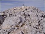
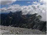
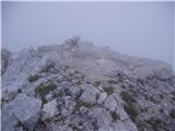
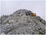
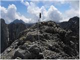
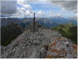
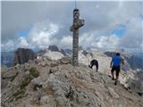
Triglav is a 2,864 m high mountain located in the heart of the Julian Alps. At this altitude, it is the highest mountain in Slovenia and also the...
6 h 15 min |
| end of road on Pokljuka - Triglav (via Planika and Mali Triglav)
Triglav is a 2,864 m high mountain located in the heart of the Julian Alps. At this altitude, it is the highest mountain in Slovenia and also the...
6 h |
 | Uskovnica (Razpotje) - Triglav (via Triglavska škrbina)
Triglav is a 2,864 m high mountain located in the heart of the Julian Alps. At this altitude, it is the highest mountain in Slovenia and also the...
6 h 25 min |
| end of road on Pokljuka - Triglav (via Planika and Triglavska škrbina)
Triglav is a 2,864 m high mountain located in the heart of the Julian Alps. At this altitude, it is the highest mountain in Slovenia and also the...
5 h 55 min |
| Rudno polje - Triglav (via Dom Planika and Mali Triglav)
Triglav is a 2,864 m high mountain located in the heart of the Julian Alps. At this altitude, it is the highest mountain in Slovenia and also the...
6 h 25 min |
| Rudno polje - Triglav (past Dom Planika and Triglavska škrbina)
Triglav is a 2,864 m high mountain located in the heart of the Julian Alps. At this altitude, it is the highest mountain in Slovenia and also the...
6 h 20 min |
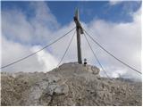
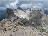
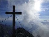
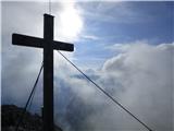
 | Aljažev dom v Vratih - Škrlatica
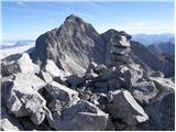
Škrlatica is the second highest mountain in Slovenia. A cross stands on the summit, making it easily recognisable from neighbouring peaks. It als...
6 h |
 | Rudno polje - Mali Triglav (via Dom Planika)
Mali Triglav is an indistinct summit on the main ridge of Triglav. Despite its considerable height, it is rarely chosen as an independent objecti...
5 h 50 min |
| Rudno polje - Mali Triglav (via Kredarica)
Mali Triglav is an indistinct summit on the main ridge of Triglav. Despite its considerable height, it is rarely chosen as an independent objecti...
6 h 5 min |
| end of road on Pokljuka - Mali Triglav (via Planika)
Mali Triglav is an indistinct summit on the main ridge of Triglav. Despite its considerable height, it is rarely chosen as an independent objecti...
5 h 25 min |
| end of road on Pokljuka - Mali Triglav (via Kredarica)
Mali Triglav is an indistinct summit on the main ridge of Triglav. Despite its considerable height, it is rarely chosen as an independent objecti...
5 h 40 min |
| Uskovnica (Razpotje) - Mali Triglav (via Planika)
Mali Triglav is an indistinct summit on the main ridge of Triglav. Despite its considerable height, it is rarely chosen as an independent objecti...
5 h 55 min |
 | Pri Mlinču - Mangart (slovenska pot)
Mangart (also spelled Mangrt; both forms are grammatically correct) is a mountain that attracts a large number of visitors in summer. Access to t...
4 h 45 min |
 | Vršič - Jalovec (via Jalovška škrbina)
At 2,645 m, Jalovec is the sixth highest mountain in Slovenia. The summit drops steeply towards three alpine valleys (Loška Koritnica, Tamar, and...
5 h 55 min |
| Vršič - Jalovec (via Zavetišče pod Špičkom)
At 2,645 m, Jalovec is the sixth highest mountain in Slovenia. The summit drops steeply towards three alpine valleys (Loška Koritnica, Tamar, and...
6 h |
 | NC Planica - Jalovec (via Jalovška škrbina)
At 2,645 m, Jalovec is the sixth highest mountain in Slovenia. The summit drops steeply towards three alpine valleys (Loška Koritnica, Tamar, and...
6 h 30 min |
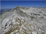
 | Vršič - Razor
The summit of Razor lies above the alpine valley of Mlinarica. Though not spacious, it offers a superb view. All the peaks above the Kriški podi ...
5 h 30 min |
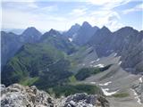
 | Ruski križ - Dolkova špica (via Kriška stena)
Dolkova špica is a 2,591 m high mountain situated between Stenar and Škrlatica. From the summit, which has a registration box, a beautiful panora...
5 h 55 min |
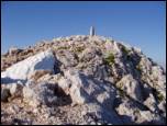
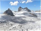
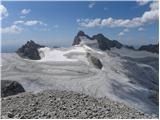
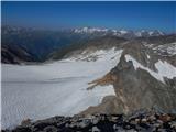
 | Gozdec - Visoki Kanin (via Zadnji dol)
Visoki Kanin is the highest peak of the Kanin mountains. From the summit, which has a cross, there is a nice view of the western Julian Alps, and...
6 h |
 | Sella Nevea - Visoki Kanin (Via ferrata Rosalba Grasselli)
Visoki Kanin is the highest peak of the Kanin mountains. From the summit, which has a cross, there is a nice view of the western Julian Alps, and...
6 h 15 min |
 | Sella Nevea - Visoki Kanin (Via ferrata Divisione Julia)
Visoki Kanin is the highest peak of the Kanin mountains. From the summit, which has a cross, there is a nice view of the western Julian Alps, and...
4 h 45 min |
 | Ravenska Kočna - Grintovec (past the cableway and on Frischaufova pot)
Grintovec is the highest peak of the Kamnik-Savinja Alps. It is located above the Kamniška Bistrica Valley, Suhi Dol, and the Ravenska Kočna Vall...
5 h 15 min |
 | Ravenska Kočna - Grintovec (past the cableway and on Kremžarjeva pot)
Grintovec is the highest peak of the Kamnik-Savinja Alps. It is located above the Kamniška Bistrica Valley, Suhi Dol, and the Ravenska Kočna Vall...
5 h 15 min |
| Ravenska Kočna - Grintovec (umik Žrela and on Frischaufova pot)
Grintovec is the highest peak of the Kamnik-Savinja Alps. It is located above the Kamniška Bistrica Valley, Suhi Dol, and the Ravenska Kočna Vall...
5 h 20 min |
| Ravenska Kočna - Grintovec (umik Žrela and on Kremžarjeva pot)
Grintovec is the highest peak of the Kamnik-Savinja Alps. It is located above the Kamniška Bistrica Valley, Suhi Dol, and the Ravenska Kočna Vall...
5 h 20 min |
 | Vršič - Prisank / Prisojnik (Kopiščarjeva pot)
Prisank (also known as Prisojnik) is a 2,547-meter-high mountain situated above the Mlinarica, Krnica, and Suha Pišnica valleys. From the summit,...
3 h 50 min |
 | Vršič - Prisank / Prisojnik (Jubilejna pot)
Prisank (also known as Prisojnik) is a 2,547-meter-high mountain situated above the Mlinarica, Krnica, and Suha Pišnica valleys. From the summit,...
6 h |
 | Koča na Gozdu - Prisank / Prisojnik (Hanzova pot)
Prisank (also known as Prisojnik) is a 2,547-meter-high mountain situated above the Mlinarica, Krnica, and Suha Pišnica valleys. From the summit,...
5 h |
| Erjavčeva koča na Vršiču - Prisank / Prisojnik (Kopiščarjeva pot)
Prisank (also known as Prisojnik) is a 2,547-meter-high mountain situated above the Mlinarica, Krnica, and Suha Pišnica valleys. From the summit,...
4 h |
| Erjavčeva koča na Vršiču - Prisank / Prisojnik (ridge path)
Prisank (also known as Prisojnik) is a 2,547-meter-high mountain situated above the Mlinarica, Krnica, and Suha Pišnica valleys. From the summit,...
3 h 45 min |
| Erjavčeva koča na Vršiču - Prisank / Prisojnik (via Kajzljeva škrbina)
Prisank (also known as Prisojnik) is a 2,547-meter-high mountain situated above the Mlinarica, Krnica, and Suha Pišnica valleys. From the summit,...
5 h |
| Erjavčeva koča na Vršiču - Prisank / Prisojnik (Jubilejna pot)
Prisank (also known as Prisojnik) is a 2,547-meter-high mountain situated above the Mlinarica, Krnica, and Suha Pišnica valleys. From the summit,...
6 h 15 min |
| Vršič - Prisank / Prisojnik (via Kajzljeva škrbina)
Prisank (also known as Prisojnik) is a 2,547-meter-high mountain situated above the Mlinarica, Krnica, and Suha Pišnica valleys. From the summit,...
4 h 30 min |
 | Ravenska Kočna - Jezerska Kočna (past the cableway and on Kremžarjeva pot)
Jezerska Kočna is located west of Grintovec. From the summit, there is a very nice view towards Grintovec. The Karawanks and the Gorenjska plain ...
5 h |
| Ravenska Kočna - Jezerska Kočna (Frischauf way)
Jezerska Kočna is located west of Grintovec. From the summit, there is a very nice view towards Grintovec. The Karawanks and the Gorenjska plain ...
6 h 30 min |
| Ravenska Kočna - Jezerska Kočna (umik Žrela and on Frischaufova pot)
Jezerska Kočna is located west of Grintovec. From the summit, there is a very nice view towards Grintovec. The Karawanks and the Gorenjska plain ...
6 h 35 min |
| Ravenska Kočna - Jezerska Kočna (umik Žrela and on Kremžarjeva pot)
Jezerska Kočna is located west of Grintovec. From the summit, there is a very nice view towards Grintovec. The Karawanks and the Gorenjska plain ...
5 h 5 min |
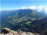
 | End of road on Pokljuka - Rjavina
Rjavina is located between two alpine valleys, Kot and Krma. From the summit, which has a logbook, there is a very nice view towards Triglav, Rž,...
6 h 25 min |
 | Ravenska Kočna - Skuta (past the cableway and over Dolgi hrbet)
Skuta is a 2,532-meter-high mountain located in the heart of the Kamnik-Savinja Alps. From the summit, which has a logbook box and a stamp, a bea...
5 h 45 min |
 | Koča pod slapom Rinka - Skuta (via Turski žleb)
Skuta is a 2,532-meter-high mountain located in the heart of the Kamnik-Savinja Alps. From the summit, which has a logbook box and a stamp, a bea...
5 h 15 min |
| Ravenska Kočna - Skuta (umik Žrela and over Dolgi hrbet)
Skuta is a 2,532-meter-high mountain located in the heart of the Kamnik-Savinja Alps. From the summit, which has a logbook box and a stamp, a bea...
5 h 50 min |
 | Ravenska Kočna - Kokrska Kočna (past the cableway and on Kremžarjeva pot)
Kokrska Kočna is a panoramic and spacious mountain between Jezersko and Suhadolnik. From the summit, which has a logbook box, there is a very nic...
5 h 30 min |
| Ravenska Kočna - Kokrska Kočna (umik Žrela and on Kremžarjeva pot)
Kokrska Kočna is a panoramic and spacious mountain between Jezersko and Suhadolnik. From the summit, which has a logbook box, there is a very nic...
5 h 35 min |
 | Ruski križ - Stenar (via Križ)
Stenar is a 2,501-meter-high peak that rises steeply above the Vrata Valley. From the spacious summit, which has a logbook box and a stamp, a bea...
6 h 15 min |
 | Ravenska Kočna - Dolgi hrbet (past the cableway and on Frischaufova pot)
Dolgi Hrbet lies between Grintovec and Skuta. From its precipitous summit there is a fine view across the heart of the Kamnik-Savinja Alps. Dolgi...
5 h |
 | Ravenska Kočna - Dolgi hrbet (umik Žrela and on Frischaufova pot)
Dolgi Hrbet lies between Grintovec and Skuta. From its precipitous summit there is a fine view across the heart of the Kamnik-Savinja Alps. Dolgi...
5 h 5 min |
 | Ruski križ - Špik (via Koča v Krnici)
Špik is a 2,472 m high mountain situated in the heart of the Martuljek group. From the summit, clearly visible from the road through Gozd Martulj...
4 h 50 min |
 | Koča pod slapom Rinka - Kranjska Rinka (via Turski žleb)
Kranjska Rinka is the highest of all the Rinka peaks. From the summit, which has a logbook, the most beautiful view is towards Skuta. The other R...
5 h 5 min |
| Koča pod slapom Rinka - Kranjska Rinka (via Koroška Rinka)
Kranjska Rinka is the highest of all the Rinka peaks. From the summit, which has a logbook, the most beautiful view is towards Skuta. The other R...
5 h 20 min |
| Ravenska Kočna - Kranjska Rinka (Slovenska pot)
Kranjska Rinka is the highest of all the Rinka peaks. From the summit, which has a logbook, the most beautiful view is towards Skuta. The other R...
4 h 35 min |
| Ravenska Kočna - Kranjska Rinka (via Žrelo)
Kranjska Rinka is the highest of all the Rinka peaks. From the summit, which has a logbook, the most beautiful view is towards Skuta. The other R...
4 h 35 min |
| Ravenska Kočna - Kranjska Rinka (hunting path)
Kranjska Rinka is the highest of all the Rinka peaks. From the summit, which has a logbook, the most beautiful view is towards Skuta. The other R...
4 h 50 min |
 | Ruski križ - Križ
Križ is a 2,140 m high mountain located northeast of the Kriški Podi plateau. The summit, which has a registration box with a stamp, offers a bea...
4 h 45 min |
 | Koča pod slapom Rinka - Koroška Rinka
Koroška Rinka (also known as Križ) is a 2433 m high mountain rising steeply above Ledine and Okrešelj. The summit has a register and stamp, offer...
5 h |
 | Koča pod slapom Rinka - Koroška Rinka (via Turski žleb)
Koroška Rinka (also known as Križ) is a 2433 m high mountain rising steeply above Ledine and Okrešelj. The summit has a register and stamp, offer...
5 h |
| Ravenska Kočna - Koroška Rinka (Slovenska pot)
Koroška Rinka (also known as Križ) is a 2433 m high mountain rising steeply above Ledine and Okrešelj. The summit has a register and stamp, offer...
4 h 15 min |
| Ravenska Kočna - Koroška Rinka (via Žrelo)
Koroška Rinka (also known as Križ) is a 2433 m high mountain rising steeply above Ledine and Okrešelj. The summit has a register and stamp, offer...
4 h 15 min |
| Ravenska Kočna - Koroška Rinka (hunting path)
Koroška Rinka (also known as Križ) is a 2433 m high mountain rising steeply above Ledine and Okrešelj. The summit has a register and stamp, offer...
4 h 30 min |
 | Koča pod slapom Rinka - Štajerska Rinka (via Turski žleb)
Štajerska Rinka is a 2374 m high mountain rising steeply above Okrešelj, more precisely east of the more visited Koroška Rinka. The summit has a ...
4 h 45 min |
 | Ravenska Kočna - Štajerska Rinka (Slovenska pot)
Štajerska Rinka is a 2374 m high mountain rising steeply above Okrešelj, more precisely east of the more visited Koroška Rinka. The summit has a ...
4 h 30 min |
| Ravenska Kočna - Štajerska Rinka (via Žrelo)
Štajerska Rinka is a 2374 m high mountain rising steeply above Okrešelj, more precisely east of the more visited Koroška Rinka. The summit has a ...
4 h 30 min |
| Ravenska Kočna - Štajerska Rinka (hunting path)
Štajerska Rinka is a 2374 m high mountain rising steeply above Okrešelj, more precisely east of the more visited Koroška Rinka. The summit has a ...
4 h 45 min |
 | Koča pod slapom Rinka - Turska gora (via Kotliči)
The mountain is located above Logarska dolina and the Kamniška Bistrica valley. From the summit, there is a beautiful view of the neighboring pea...
4 h 30 min |
 | Koča pod slapom Rinka - Turska gora (via Turski žleb)
The mountain is located above Logarska dolina and the Kamniška Bistrica valley. From the summit, there is a beautiful view of the neighboring pea...
4 h 15 min |
 | Ravenska Kočna - Mrzla gora (Slovenian way)
This difficult-to-access mountain is located on the border with Austria in the Kamnik-Savinja Alps. From the summit there is a beautiful view tow...
5 h 45 min |
| Koča pod slapom Rinka - Mrzla gora
This difficult-to-access mountain is located on the border with Austria in the Kamnik-Savinja Alps. From the summit there is a beautiful view tow...
4 h 30 min |
| Ravenska Kočna - Mrzla gora (via Žrelo)
This difficult-to-access mountain is located on the border with Austria in the Kamnik-Savinja Alps. From the summit there is a beautiful view tow...
5 h 45 min |
| Ravenska Kočna - Mrzla gora (hunting path)
This difficult-to-access mountain is located on the border with Austria in the Kamnik-Savinja Alps. From the summit there is a beautiful view tow...
6 h |
 | Pecol - Jôf di Montasio/Montaž (via Findenegg couloir)
Montaž is one of the most imposing and, at 2,753 m, the second-highest mountain in the Julian Alps. Its authentic Slovenian name is Špik nad Poli...
3 h 45 min |
 | Prebersee - Roteck
Roteck is a 2742 m high peak located north of Tamsweg in the heart of the Lower Tauern. From the summit, where a cross stands, there is a nice vi...
4 h |
 | Cave del Mole - Viš/Jof Fuart (Anita Goitan)
Viš is a 2,666 m high peak in the western Julian Alps. From the summit, which features a statue of St. Mary and a cross beside it, there are fine...
5 h 30 min |
 | Pecol - Cima di Terrarossa (Leva)
Špik Hude police is a 2431-meter-high panoramic peak (new LiDAR measurement; this height will also be shown on newer maps, while older maps still...
4 h 30 min |
 | Piano Fiscalino / Fischleinboden - Monte Paterno (Ferrata De Luca-Innerkofler)
Monte Paterno is a 2744-meter-high panoramic peak. From the top, there is a breathtaking view in all directions, especially the Tre Cime to the w...
4 h 10 min |
 | Rifugio Tolazzi - Monte Capolago / Seekopf
Monte Capolago / Seekopf is a highly panoramic mountain located on the Austria-Italy border directly above Lake Wolayersee. From the summit there...
3 h 45 min |
 | Lienzer Dolomitenhütte - Große Sandspitze (Ari Schübel)
Große Sandspitze, at 2772 meters, is the highest peak of the Lienz Dolomites. From the summit, which has a summit register box, a breathtaking vi...
3 h 45 min |
 | Lienzer Dolomitenhütte - Galitzenspitzen
Galitzenspitzen is a 2710-meter-high mountain situated on the ridge between Roter Turm and the highest peak of the Lienz Dolomites, Große Sandspi...
4 h |
 | Pecol - Foronon del Buinz / Špik nad Nosom (Ceria Merlone)
Špik nad Nosom is a 2,531 m high mountain located in the ridge between Montaž and Viš. From its rocky summit on a clear day, views open up to the...
3 h 45 min |
 | Sella Nevea - Foronon del Buinz / Špik nad Nosom (via Forcella Lavinal dell Orso)
Špik nad Nosom is a 2,531 m high mountain located in the ridge between Montaž and Viš. From its rocky summit on a clear day, views open up to the...
6 h |
 | Sella Nevea - Vrh Krnice
Vrh Krnice is a 2,441-meter-high peak located northwest of Visoki Kanin. From the summit, where there is usually an empty logbook box, there is a...
5 h 15 min |
 | Alba di Canazei - Colac (path 646)
Colac is a 2715-meter-high mountain located on the western side of the Marmolada mountain group. From the summit, which features a cross, there i...
4 h |
 | Passo Tre Croci - Cristallino d'Ampezzo
Cristallino d'Ampezzo is a 3008-meter-high mountain in the Cristallo group. It is very popular because a cable car reaches almost 3000 meters.Fro...
3 h 40 min |
 | Rifugio Pederü - Piz dles Conturines
Piz dles Conturines, at 3064 m, is the highest peak in the Lavarella group. From the cross-topped summit, there are fine views of the entire grou...
6 h 30 min |
 | Parking Erichhütte - Hoher Kopf (path 432)
Hoher Kopf is located in the Berchtesgaden Alps, west of the highest peak, Höchkonig. The summit is popular mainly due to the protected climbing ...
4 h 45 min |
 | Türlwandhütte - Hunerkogel
Hunerkogel is a 2,685-meter peak above the Schladming Glacier. From the summit there are beautiful views of the peaks above the glacier, and the ...
4 h |
 | Türlwandhütte - Kleiner Koppenkarstein (via Hunerscharte)
Kleiner Koppenkarstein is a 2,832-meter peak in the Dachstein mountain group. This indistinct summit is located on the Koppenkarstein ridge above...
4 h 15 min |
 | Türlwandhütte - Großer Koppenkarstein (via Hunerscharte)
Großer Koppenkarstein is a 2865-meter-high mountain in the Dachstein mountain group. It is situated above the Schladminger Gletscher glacier. Fro...
4 h 50 min |
 | Türlwandhütte - Hoher Dachstein (via Hunerscharte)
Hoher Dachstein is, at 2995 meters, the highest peak of the Dachstein mountain group. The summit is located on the border between the federal sta...
5 h 45 min |
 | Parkplatz Erichhütte - Hochkönig (path 432)
Hochkönig is, at 2941 meters, the highest peak of the Berchtesgaden Alps. The peak, on which the Matrashaus mountain hut stands, is very well vis...
5 h 20 min |
 | Türlwandhütte - Kleiner Gjaidstein (via Hunerscharte)
Kleiner Gjaidstein is a 2735-meter-high peak in the Dachstein mountain group. The summit is situated on the ridge between the glaciers Schladming...
4 h 30 min |
 | Türlwandhütte - Hoher Gjaidstein (via Hunerscharte)
Hoher Gjaidstein is a 2792-meter-high peak in the Dachstein mountain group. The summit is situated on the ridge between glaciers Schladminger Gle...
5 h |
 | Alba di Canazei - Cima Ombretta (Via Ferrata Ombretta)
Cima Ombretta is a 3,011-meter-high peak in the Marmolada mountain group. From the summit, where a cross stands, there is the finest view of the ...
5 h 15 min |
 | Palafavera - Monte Civetta (Via Normale)
Monte Civetta is one of the main mountains in the Dolomites. It is recognizable primarily by its more than 1000-meter-high northwestern wall. Thi...
6 h 20 min |
 | Rifugio Pederü - Sasso delle Dieci / Zehnerspitze (path 12)
Sasso delle Dieci / Zehnerspitze is a 3,028-meter-high mountain rising steeply above Val Badia valley. Sasso delle Dieci is the highest peak in t...
5 h 30 min |
| Rifugio Pederü - Sasso delle Dieci / Zehnerspitze (path 7)
Sasso delle Dieci / Zehnerspitze is a 3,028-meter-high mountain rising steeply above Val Badia valley. Sasso delle Dieci is the highest peak in t...
5 h 35 min |
 | Ristorante Pietofana - Cima Formenton (via Rifugio Pomedes)
Cima Formenton is a 2,830-meter-high peak in the Tofana group. The mountain lies north of the better-known Tofana di Dentro, with an unmarked tra...
5 h 5 min |
 | Klammbrückl - Spitzkofel
Spitzkofel is a 2717-meter-high mountain in the Lienz Dolomites. From the summit, where a large cross stands, there is a very nice view of the en...
5 h |
 | Klammbrückl - Weittalspitze (Allmaier Toni Weg)
Weittalspitze is a 2539-meter-high peak in the Lienz Dolomites. The summit is located south of the Kerschbaumeralm pasture. From the top, where a...
4 h 30 min |
 | Lenzanger - Hoher Sonnblick (via Goldzechkopf)
Hoher Sonnblick, also known as Rauriser Sonnblick, is a 3106-meter-high mountain in the Goldberg group. The Zittelhaus hut and Austria's highest ...
6 h 30 min |
 | Lenzanger - Goldzechkopf (via Hoher Sonnblick)
Goldzechkopf is a 3042-meter-high peak in the Goldberg mountain group. The summit is located on the ridge between the better-known Hoher Sonnblic...
6 h 10 min |
 | Obermoos - Zugspitze (Stopselziehersteig)
Zugspitze, at 2,962 meters, is the highest peak of the Wetterstein group and also Germany's highest mountain. It lies south of Garmisch-Partenkir...
5 h |
 | Passo di Costalunga / Karerpass - Roda di Vael / Rotwand (Via Ferrata Majare)
Roda di Vael (German: Rotwand) is a 2,806-meter-high mountain in the Catinaccio (Rosengarten) group. The mountain is recognizable mainly by its s...
5 h 30 min |
 | Passo di Costalunga / Karerpass - Roda di Vael / Rotwand (via Passo dal Vaiolon)
Roda di Vael (German: Rotwand) is a 2,806-meter-high mountain in the Catinaccio (Rosengarten) group. The mountain is recognizable mainly by its s...
4 h |
 | Passo di Costalunga / Karerpass - Cima Latemar / Latemarspitze
Cima Latemar (also Schenon Latemar, German: Latemarspitze) is a 2,800-meter-high peak in the Latemar mountain group. From the summit, where a lar...
3 h 40 min |
| Passo di Costalunga / Karerpass - Cima Latemar / Latemarspitze (via Malga Vallace)
Cima Latemar (also Schenon Latemar, German: Latemarspitze) is a 2,800-meter-high peak in the Latemar mountain group. From the summit, where a lar...
3 h 50 min |
 | Seichenbrunn - Glödis
Glödis (or Glödisspitze) is a 3,206-meter-high mountain in the Schober group within Hohe Tauern National Park. The summit, crowned by a large cro...
5 h |
 | Piano Fiscalino / Fischleinboden - Croda Rossa di Sesto (Via Ferrata Croda Rossa)
Croda Rossa di Sesto (German: Sextner Rotwand, also Zehner) is a 2,965-meter-high mountain in the Sexten Dolomites (Dolomiti di Sesto). The mount...
5 h |
 | Plockenpass - Pilastro del Coglians
Pilastro del Coglians is a 2,750-metre peak east of Monte Coglians on the Austria-Italy border. A summit logbook is located on the compact summit...
4 h 30 min |
| Rifugio Tolazzi - Pilastro del Coglians (via Rifugio Marinelli)
Pilastro del Coglians is a 2,750-metre peak east of Monte Coglians on the Austria-Italy border. A summit logbook is located on the compact summit...
3 h 55 min |
 | Rifugio Cercena - Cima Montanel
Cima Montanel is a 2,461-meter-high peak above the Piave river valley in the Carnic Prealps. The summit, which bears a cross, is an exceptional v...
4 h 40 min |
| Rifugio Padova - Cima Montanel (via Forcella di Crodon)
Cima Montanel is a 2,461-meter-high peak above the Piave river valley in the Carnic Prealps. The summit, which bears a cross, is an exceptional v...
4 h 50 min |
 | Rifugio Pederü - Cima Nove / Neunerspitze
The Italian Cima Nove or Sasso delle Nove, German Neuner or Neunerspitze, Ladin Sas dles Nü or Nönör is a 2,968-meter-high peak in the Fanes-Sene...
4 h 50 min |
 | Plöckenpass - Creta di Collina / Kollinkofel (path 171)
Creta di Collina (German: Kollinkofel) is a 2,691-meter-high mountain in the Carnic Alps. In the immediate surroundings of the mountain, there ar...
4 h |
 | Plöckenpass - Creta di Collina / Kollinkofel (via Cresta Verde)
Creta di Collina (German: Kollinkofel) is a 2,691-meter-high mountain in the Carnic Alps. In the immediate surroundings of the mountain, there ar...
4 h |
 | Plöckenpass - Creta della Chianevate / Kellerspitzen (path 171)
Creta della Chianevate (German: Kellerspitzen) is a 2,769-meter peak in the central Carnic Alps on the AustriaItaly border. From the summit, mark...
4 h 50 min |
| Plöckenpass - Creta della Chianevate / Kellerspitzen (via Cresta Verde)
Creta della Chianevate (German: Kellerspitzen) is a 2,769-meter peak in the central Carnic Alps on the AustriaItaly border. From the summit, mark...
5 h |
 | Edelweiss - Monte Volaia / Wolayer Kopf (path 176)
Italian Monte Volaia, German Wolayer Kopf, is a 2470-meter-high peak in the main ridge of the Carnic Alps west of the highest peak Monte Coglians...
3 h 45 min |
| Collina - Monte Volaia / Wolayer Kopf (path 141)
Italian Monte Volaia, German Wolayer Kopf, is a 2470-meter-high peak in the main ridge of the Carnic Alps west of the highest peak Monte Coglians...
4 h |
 | Capanna Alpina - Furcia Rossa III
Furcia Rossa III is a 2,791-meter-high peak in a somewhat more remote ridge along which the Walk of Peace (Fridensweg / Via della Pace) runs. At ...
4 h 30 min |
| Rifugio Pederü - Furcia Rossa III
Furcia Rossa III is a 2,791-meter-high peak in a somewhat more remote ridge along which the Walk of Peace (Fridensweg / Via della Pace) runs. At ...
4 h 50 min |
 | parking lot Stupfer in Gaistal - Hohe Munde - western peak (on climbing path via western ridge)
Hohe Munde is a peak in the Mieming range west of Innsbruck and the local mountain of the town of Telfs, appearing as an imposing rock fortress a...
6 h 15 min |
 | Gozdec - Vrh Laške Planje
Vrh Laške Planje (Lasca Plagna) is a 2,448-meter-high peak located on the border ridge between Italy and Slovenia. From the top there is a magnif...
5 h |
 | Coot Parking Lot - Vrh Laške Planje
Vrh Laške Planje (Lasca Plagna) is a 2,448-meter-high peak located on the border ridge between Italy and Slovenia. From the top there is a magnif...
5 h 45 min |
 | Gozdec - Črni Vogel
Črni Vogel (Italian: Cerni Vogu) is a 2,422-meter-high peak located in the Kanin Mountains on the border between Italy and Slovenia. The Visoka R...
5 h 30 min |
 | Coot Parking Lot - Vrh Žlebi / Monte Slebe
Vrh Žlebi (also known as Žbrančev zob, Italian: Monte Slebe) lies in the Kanin Mountains on the border between Italy and Slovenia, east of the Žl...
4 h 45 min |
 | Gozdec - Pod Kaninom (Alta Via Resiana)
Pod Kaninom is an indistinct peak on the border ridge south of Visoki Kanin. From the summit, an exceptional view opens up to Kanin and the mount...
6 h 15 min |