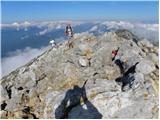
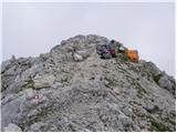
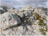
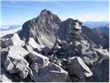
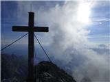
 | Pri Mlinču - Mangart (slovenska pot)
Mangart (also spelled Mangrt; both forms are grammatically correct) is a mountain that attracts a large number of visitors in summer. Access to t...
4 h 45 min |
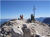
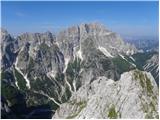
 | Sella Nevea - Visoki Kanin (Via ferrata Divisione Julia)
Visoki Kanin is the highest peak of the Kanin mountains. From the summit, which has a cross, there is a nice view of the western Julian Alps, and...
4 h 45 min |
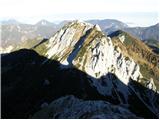
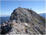
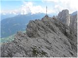
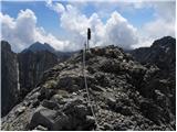
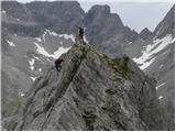
 | Vršič - Prisank / Prisojnik (ridge way)
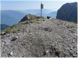
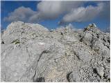
Prisank (also known as Prisojnik) is a 2,547-meter-high mountain situated above the Mlinarica, Krnica, and Suha Pišnica valleys. From the summit,...
3 h 30 min |
| Vršič - Prisank / Prisojnik (Kopiščarjeva pot)
Prisank (also known as Prisojnik) is a 2,547-meter-high mountain situated above the Mlinarica, Krnica, and Suha Pišnica valleys. From the summit,...
3 h 50 min |
 | Koča na Gozdu - Prisank / Prisojnik (Hanzova pot)
Prisank (also known as Prisojnik) is a 2,547-meter-high mountain situated above the Mlinarica, Krnica, and Suha Pišnica valleys. From the summit,...
5 h |
| Erjavčeva koča na Vršiču - Prisank / Prisojnik (Kopiščarjeva pot)
Prisank (also known as Prisojnik) is a 2,547-meter-high mountain situated above the Mlinarica, Krnica, and Suha Pišnica valleys. From the summit,...
4 h |
| Erjavčeva koča na Vršiču - Prisank / Prisojnik (ridge path)
Prisank (also known as Prisojnik) is a 2,547-meter-high mountain situated above the Mlinarica, Krnica, and Suha Pišnica valleys. From the summit,...
3 h 45 min |
 | Erjavčeva koča na Vršiču - Prisank / Prisojnik (via Kajzljeva škrbina)
Prisank (also known as Prisojnik) is a 2,547-meter-high mountain situated above the Mlinarica, Krnica, and Suha Pišnica valleys. From the summit,...
5 h |
| Vršič - Prisank / Prisojnik (via Kajzljeva škrbina)
Prisank (also known as Prisojnik) is a 2,547-meter-high mountain situated above the Mlinarica, Krnica, and Suha Pišnica valleys. From the summit,...
4 h 30 min |
 | Aljažev dom v Vratih - Triglavski dom na Kredarici (Tominšek route)
The Triglav Hut at Kredarica is the highest-lying serviced Slovenian mountain hut. It is open all year round but outside the season only on an em...
4 h 55 min |
| Aljažev dom v Vratih - Triglavski dom na Kredarici (via Prag)
The Triglav Hut at Kredarica is the highest-lying serviced Slovenian mountain hut. It is open all year round but outside the season only on an em...
5 h |
 | Ravenska Kočna - Jezerska Kočna (past the cableway and on Kremžarjeva pot)
Jezerska Kočna is located west of Grintovec. From the summit, there is a very nice view towards Grintovec. The Karawanks and the Gorenjska plain ...
5 h |
| Ravenska Kočna - Jezerska Kočna (umik Žrela and on Kremžarjeva pot)
Jezerska Kočna is located west of Grintovec. From the summit, there is a very nice view towards Grintovec. The Karawanks and the Gorenjska plain ...
5 h 5 min |
| Ravenska Kočna - Jezerska Kočna (via Štularjeva planina and on path Kremžarjeva pot)
Jezerska Kočna is located west of Grintovec. From the summit, there is a very nice view towards Grintovec. The Karawanks and the Gorenjska plain ...
5 h |
 | Ravenska Kočna - Dolgi hrbet (past the cableway and on Frischaufova pot)
Dolgi Hrbet lies between Grintovec and Skuta. From its precipitous summit there is a fine view across the heart of the Kamnik-Savinja Alps. Dolgi...
5 h |
 | Ravenska Kočna - Dolgi hrbet (umik Žrela and on Frischaufova pot)
Dolgi Hrbet lies between Grintovec and Skuta. From its precipitous summit there is a fine view across the heart of the Kamnik-Savinja Alps. Dolgi...
5 h 5 min |
| Ravenska Kočna - Dolgi hrbet (via Štularjeva planina and on path Frischaufova pot)
Dolgi Hrbet lies between Grintovec and Skuta. From its precipitous summit there is a fine view across the heart of the Kamnik-Savinja Alps. Dolgi...
5 h |
 | Ruski križ - Špik (via Koča v Krnici)
Špik is a 2,472 m high mountain situated in the heart of the Martuljek group. From the summit, clearly visible from the road through Gozd Martulj...
4 h 50 min |
 | Aljažev dom v Vratih - Begunjski vrh (via Prag)
Begunjski Vrh is a 2,461 m high mountain located in the heart of the highest peaks of the Julian Alps. From the summit, which has a registration ...
5 h |
| Aljažev dom v Vratih - Begunjski vrh (Tominšek route)
Begunjski Vrh is a 2,461 m high mountain located in the heart of the highest peaks of the Julian Alps. From the summit, which has a registration ...
4 h 55 min |
 | Koča pod slapom Rinka - Kranjska Rinka (via Turski žleb)
Kranjska Rinka is the highest of all the Rinka peaks. From the summit, which has a logbook, the most beautiful view is towards Skuta. The other R...
5 h 5 min |
| Ravenska Kočna - Kranjska Rinka (Slovenska pot)
Kranjska Rinka is the highest of all the Rinka peaks. From the summit, which has a logbook, the most beautiful view is towards Skuta. The other R...
4 h 35 min |
| Belska Kočna - Kranjska Rinka
Kranjska Rinka is the highest of all the Rinka peaks. From the summit, which has a logbook, the most beautiful view is towards Skuta. The other R...
5 h 5 min |
| Ravenska Kočna - Kranjska Rinka (via Žrelo)
Kranjska Rinka is the highest of all the Rinka peaks. From the summit, which has a logbook, the most beautiful view is towards Skuta. The other R...
4 h 35 min |
| Ravenska Kočna - Kranjska Rinka (hunting path)
Kranjska Rinka is the highest of all the Rinka peaks. From the summit, which has a logbook, the most beautiful view is towards Skuta. The other R...
4 h 50 min |
 | Trate / Johannsenruhe - Hochstuhl/Stol (climbing way)
Stol is, at 2,236 m, the highest peak in the Karawanks. From the summit, which has a registration box and stamp, a beautiful view opens onto the ...
3 h 20 min |
 | Vranček - Veliki vrh (Košuta) (climbing way)
Veliki Vrh, at 2,088 m, is the westernmost two-thousander in Slovenia's longest ridge, the Košuta. From the summit, which has a registration box ...
3 h 10 min |
| Ljubelj - Veliki vrh (Košuta) (via Koča na Ljubelju)
Veliki Vrh, at 2,088 m, is the westernmost two-thousander in Slovenia's longest ridge, the Košuta. From the summit, which has a registration box ...
3 h 50 min |
| Bučan - Veliki vrh (Košuta)
Veliki Vrh, at 2,088 m, is the westernmost two-thousander in Slovenia's longest ridge, the Košuta. From the summit, which has a registration box ...
3 h 50 min |
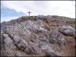 | Dom pod Storžičem - Storžič (through Žrelo)
Storžič is a 2132 m high mountain located in the western part of the Kamnik-Savinja Alps. From the summit, where there is a cross, a beautiful vi...
3 h |
 | Dom pod Storžičem - Storžič (via Psica)
Storžič is a 2132 m high mountain located in the western part of the Kamnik-Savinja Alps. From the summit, where there is a cross, a beautiful vi...
3 h 45 min |
| Gozd - Storžič (via Psica)
Storžič is a 2132 m high mountain located in the western part of the Kamnik-Savinja Alps. From the summit, where there is a cross, a beautiful vi...
4 h 50 min |
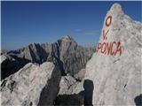 | NC Planica - Visoka Ponca
Visoka Ponca lies on the border with Italy and offers a beautiful view of the mountains above the Tamar valley and the Italian Julian Alps. From ...
4 h 45 min |
| Belopeška jezera - Visoka Ponca (via normale)
Visoka Ponca lies on the border with Italy and offers a beautiful view of the mountains above the Tamar valley and the Italian Julian Alps. From ...
4 h |
 | Belopeška jezera - Visoka Ponca (ferrata)
Visoka Ponca lies on the border with Italy and offers a beautiful view of the mountains above the Tamar valley and the Italian Julian Alps. From ...
4 h |
 | NC Planica - Mala Mojstrovka (via Grlo)
Mala Mojstrovka is one of the most visited peaks in the Julian Alps due to the relatively high elevation of its starting point. From the summit, ...
4 h 35 min |
 | Ruski križ - Križ
Križ is a 2,140 m high mountain located northeast of the Kriški Podi plateau. The summit, which has a registration box with a stamp, offers a bea...
4 h 45 min |
 | V Koncu - Kalški greben
Kalški greben is a 2224 m high peak and the highest point of the ridge bearing the same name. From the summit, where there is a summit register a...
4 h |
| Suhadolnik - Kalški greben
Kalški greben is a 2224 m high peak and the highest point of the ridge bearing the same name. From the summit, where there is a summit register a...
4 h 15 min |
 | Aljažev dom v Vratih - Visoka Vrbanova špica (via Prag)
Visoka Vrbanova špica is located at the far southwestern end of the ridge rising above the Kot and Vrata valleys, and higher up between the Kot a...
4 h 50 min |
 | The Kot Valley - Visoka Vrbanova špica (Lojze Rekar route)
Visoka Vrbanova špica is located at the far southwestern end of the ridge rising above the Kot and Vrata valleys, and higher up between the Kot a...
5 h 10 min |
| Aljažev dom v Vratih - Visoka Vrbanova špica (Tominšek route)
Visoka Vrbanova špica is located at the far southwestern end of the ridge rising above the Kot and Vrata valleys, and higher up between the Kot a...
4 h 45 min |
 | Sele pri Cerkvi / Zell - Pfarre - Koschutnikturm (Košutnikov turn) (ÖTK Steig Neu)
Košutnikov Turn is the highest peak in Košuta, the longest Slovenian ridge. The summit offers a beautiful view of the entire ridge. Austria and t...
4 h |
 | Ravenska Kočna - Ledinski vrh (Slovenian way)
The mountain is located above Jezersko and lies on the border with Austria. From the summit there is a beautiful view north towards the neighbour...
3 h 15 min |
| Ravenska Kočna - Ledinski vrh (via Žrelo)
The mountain is located above Jezersko and lies on the border with Austria. From the summit there is a beautiful view north towards the neighbour...
3 h 15 min |
 | Koča pod slapom Rinka - Koroška Rinka
Koroška Rinka (also known as Križ) is a 2433 m high mountain rising steeply above Ledine and Okrešelj. The summit has a register and stamp, offer...
5 h |
 | Koča pod slapom Rinka - Koroška Rinka (via Turski žleb)
Koroška Rinka (also known as Križ) is a 2433 m high mountain rising steeply above Ledine and Okrešelj. The summit has a register and stamp, offer...
5 h |
| Ravenska Kočna - Koroška Rinka (Slovenska pot)
Koroška Rinka (also known as Križ) is a 2433 m high mountain rising steeply above Ledine and Okrešelj. The summit has a register and stamp, offer...
4 h 15 min |
| Belska Kočna - Koroška Rinka
Koroška Rinka (also known as Križ) is a 2433 m high mountain rising steeply above Ledine and Okrešelj. The summit has a register and stamp, offer...
4 h 45 min |
| Ravenska Kočna - Koroška Rinka (via Žrelo)
Koroška Rinka (also known as Križ) is a 2433 m high mountain rising steeply above Ledine and Okrešelj. The summit has a register and stamp, offer...
4 h 15 min |
| Ravenska Kočna - Koroška Rinka (hunting path)
Koroška Rinka (also known as Križ) is a 2433 m high mountain rising steeply above Ledine and Okrešelj. The summit has a register and stamp, offer...
4 h 30 min |
 | Koča pod slapom Rinka - Štajerska Rinka (via Turski žleb)
Štajerska Rinka is a 2374 m high mountain rising steeply above Okrešelj, more precisely east of the more visited Koroška Rinka. The summit has a ...
4 h 45 min |
 | Ravenska Kočna - Štajerska Rinka (Slovenska pot)
Štajerska Rinka is a 2374 m high mountain rising steeply above Okrešelj, more precisely east of the more visited Koroška Rinka. The summit has a ...
4 h 30 min |
| Ravenska Kočna - Štajerska Rinka (via Žrelo)
Štajerska Rinka is a 2374 m high mountain rising steeply above Okrešelj, more precisely east of the more visited Koroška Rinka. The summit has a ...
4 h 30 min |
| Ravenska Kočna - Štajerska Rinka (hunting path)
Štajerska Rinka is a 2374 m high mountain rising steeply above Okrešelj, more precisely east of the more visited Koroška Rinka. The summit has a ...
4 h 45 min |
 | Koča pod slapom Rinka - Turska gora (via Kotliči)
The mountain is located above Logarska dolina and the Kamniška Bistrica valley. From the summit, there is a beautiful view of the neighboring pea...
4 h 30 min |
| Jermanca - Turska gora (via Kamniško sedlo)
The mountain is located above Logarska dolina and the Kamniška Bistrica valley. From the summit, there is a beautiful view of the neighboring pea...
4 h 45 min |
 | Koča pod slapom Rinka - Turska gora (via Turski žleb)
The mountain is located above Logarska dolina and the Kamniška Bistrica valley. From the summit, there is a beautiful view of the neighboring pea...
4 h 15 min |
 | Koča pod slapom Rinka - Mrzla gora
This difficult-to-access mountain is located on the border with Austria in the Kamnik-Savinja Alps. From the summit there is a beautiful view tow...
4 h 30 min |
 | Pecol - Jôf di Montasio/Montaž (over Pipan's ladder)
Montaž is one of the most imposing and, at 2,753 m, the second-highest mountain in the Julian Alps. Its authentic Slovenian name is Špik nad Poli...
3 h 30 min |
 | Pecol - Jôf di Montasio/Montaž (via Findenegg couloir)
Montaž is one of the most imposing and, at 2,753 m, the second-highest mountain in the Julian Alps. Its authentic Slovenian name is Špik nad Poli...
3 h 45 min |
 | Planina Zajzera - Jof di Miezegnot/Poldašnja špica
Poldašnja špica is the easternmost two-thousander in the Malborghetto mountains group (Monti di Malborgheto). From the mountain, which has many r...
3 h |
 | Planina Zajzera - Cima Alta (Due Pizzi) (path 648)
Dve špici (Due Pizzi) comprise two peaks in the Naborjet mountains group, namely Cima Alta (2046 m) and Cima Vildiver (2008 m). Both peaks have a...
4 h |
 | Rudnik v Topli - Petzen (Kordeschkopf) (Peca (Kordeževa glava)) (via Dom na Peci - climbing way)
Kordeževa glava, better known as Peca, is the highest peak of the Peca range. It is located on the border with Austria above the Mežiška dolina v...
3 h 30 min |
| Podpeca (Mitnek) - Petzen (Kordeschkopf) (Peca (Kordeževa glava)) (climbing way)
Kordeževa glava, better known as Peca, is the highest peak of the Peca range. It is located on the border with Austria above the Mežiška dolina v...
4 h 15 min |
| Koča na Pikovem - Petzen (Kordeschkopf) (Peca (Kordeževa glava)) (over saddle Vrh šteng and on climbing way)
Kordeževa glava, better known as Peca, is the highest peak of the Peca range. It is located on the border with Austria above the Mežiška dolina v...
3 h 45 min |
 | Ravenska Kočna - Velika (Koroška) Baba (on Slovenska and climbing way)
Velika (Koroška) Baba is a 2127 m high mountain on the border ridge above the Ravenska Kočna valley on the Slovenian side and above the Bela (Bel...
3 h 45 min |
| Ravenska Kočna - Velika (Koroška) Baba (on Slovenska pot and over Jezersko sedlo)
Velika (Koroška) Baba is a 2127 m high mountain on the border ridge above the Ravenska Kočna valley on the Slovenian side and above the Bela (Bel...
4 h 15 min |
| Ravenska Kočna - Velika (Koroška) Baba (through Žrelo and on climbing way)
Velika (Koroška) Baba is a 2127 m high mountain on the border ridge above the Ravenska Kočna valley on the Slovenian side and above the Bela (Bel...
3 h 45 min |
| Ravenska Kočna - Velika (Koroška) Baba (on hunting and climbing path)
Velika (Koroška) Baba is a 2127 m high mountain on the border ridge above the Ravenska Kočna valley on the Slovenian side and above the Bela (Bel...
4 h |
| Ravenska Kočna - Velika (Koroška) Baba (through Žrelo and over Jezersko sedlo)
Velika (Koroška) Baba is a 2127 m high mountain on the border ridge above the Ravenska Kočna valley on the Slovenian side and above the Bela (Bel...
4 h 15 min |
 | Zadnja Trenta (Flori) - Bavški Grintavec (via Kanski preval)
Bavški Grintavec is a mighty mountain that rises steeply above the valleys of Bavšica, Zadnja Trenta, and Soča. All approaches to the summit are ...
4 h 45 min |
| Zadnja Trenta (Flori) - Bavški Grintavec (direct way)
Bavški Grintavec is a mighty mountain that rises steeply above the valleys of Bavšica, Zadnja Trenta, and Soča. All approaches to the summit are ...
4 h 30 min |
 | The Kot Valley - Spodnja Vrbanova špica (via Lojze Rekar)
Spodnja Vrbanova špica is a 2,299 m high mountain above Kot valley and Za Cmirom valley. From the summit there is a very nice view toward Rjavina...
4 h |
 | Planina Kuk - Vrh nad Škrbino (via Škrbina)
Vrh nad Škrbino is the easternmost two-thousander in the ridge of the Lower Bohinj Mountains. From the summit, there are excellent views of the n...
3 h 45 min |
| Ski hotel Vogel - Vrh nad Škrbino
Vrh nad Škrbino is the easternmost two-thousander in the ridge of the Lower Bohinj Mountains. From the summit, there are excellent views of the n...
4 h 50 min |
| Tolminske Ravne - Vrh nad Škrbino (on steep pathi and over Škrbina)
Vrh nad Škrbino is the easternmost two-thousander in the ridge of the Lower Bohinj Mountains. From the summit, there are excellent views of the n...
4 h |
 | Reißkofelbad - Reißkofel (via bivouac)
Reißkofel is a 2371 m high mountain in the Gailtal Alps. The summit, marked by a cross, also features a summit register. The view is particularly...
4 h 30 min |
 | Prebersee - Roteck
Roteck is a 2742 m high peak located north of Tamsweg in the heart of the Lower Tauern. From the summit, where a cross stands, there is a nice vi...
4 h |
 | Belopeška jezera - Srednja Ponca / Ponza di Mezze
Srednja Ponca is a 2,228-meter-high peak rising steeply above Tamar, Planica, and Mangartska Dolina. From the summit, which has a stamp, there ar...
3 h 45 min |
 | NC Planica - Zadnja Ponca / Ponza di Detro
Zadnja Ponca is a 2,242-meter-high peak located on the narrow and precipitous Ponca ridge. From the summit, which is not accessible to everyone, ...
4 h 50 min |
| Belopeška jezera - Zadnja Ponca / Ponza di Detro
Zadnja Ponca is a 2,242-meter-high peak located on the narrow and precipitous Ponca ridge. From the summit, which is not accessible to everyone, ...
4 h 30 min |
 | Pecol - Cima di Terrarossa (Leva)
Špik Hude police is a 2431-meter-high panoramic peak (new LiDAR measurement; this height will also be shown on newer maps, while older maps still...
4 h 30 min |
 | Piano Fiscalino / Fischleinboden - Monte Paterno (Ferrata De Luca-Innerkofler)
Monte Paterno is a 2744-meter-high panoramic peak. From the top, there is a breathtaking view in all directions, especially the Tre Cime to the w...
4 h 10 min |
 | Rifugio Tolazzi - Monte Capolago / Seekopf
Monte Capolago / Seekopf is a highly panoramic mountain located on the Austria-Italy border directly above Lake Wolayersee. From the summit there...
3 h 45 min |
 | Jakobe - Feistritzer Spitze (climbing way)
Bistriška špica is a 2113 m high peak located on the Austrian side of Peca. From the summit, which features a cross, there is a fine view of the ...
3 h 45 min |
 | Velacher Kotschna/Belska Kočna - Vellacher Turm/Storžek
Storžek (or Belski turn) is a 2,110-meter-high mountain on the Austrian side of Jezersko sedlo. The summit, which is not marked on most Slovenian...
3 h 15 min |
| Koča pod slapom Rinka - Vellacher Turm/Storžek
Storžek (or Belski turn) is a 2,110-meter-high mountain on the Austrian side of Jezersko sedlo. The summit, which is not marked on most Slovenian...
3 h 45 min |
| Ravenska Kočna - Vellacher Turm/Storžek (Slovenska pot)
Storžek (or Belski turn) is a 2,110-meter-high mountain on the Austrian side of Jezersko sedlo. The summit, which is not marked on most Slovenian...
4 h |
| Ravenska Kočna - Vellacher Turm/Storžek (via Žrelo)
Storžek (or Belski turn) is a 2,110-meter-high mountain on the Austrian side of Jezersko sedlo. The summit, which is not marked on most Slovenian...
4 h |
| Ravenska Kočna - Vellacher Turm/Storžek (hunting path)
Storžek (or Belski turn) is a 2,110-meter-high mountain on the Austrian side of Jezersko sedlo. The summit, which is not marked on most Slovenian...
4 h 15 min |
 | Lienzer Dolomitenhütte - Große Sandspitze (Ari Schübel)
Große Sandspitze, at 2772 meters, is the highest peak of the Lienz Dolomites. From the summit, which has a summit register box, a breathtaking vi...
3 h 45 min |
 | Lienzer Dolomitenhütte - Teplitzer Spitze
Teplitzer Spitze is a 2613-meter-high mountain situated southwest of Lake Laserzsee. From its somewhat spacious summit, a nice view opens up on t...
3 h |
 | Lienzer Dolomitenhütte - Laserzkopf
Laserzkopf is a 2718-meter-high mountain situated near the highest peak of the Lienz Dolomites. From its summit, which has a cross, a nice view o...
3 h 30 min |
 | Lienzer Dolomitenhütte - Galitzenspitzen
Galitzenspitzen is a 2710-meter-high mountain situated on the ridge between Roter Turm and the highest peak of the Lienz Dolomites, Große Sandspi...
4 h |
 | Lienzer Dolomitenhütte - Große Gamswiesenspitze (Normalweg)
Große Gamswiesenspitze is a 2,488-meter-high mountain located in the heart of the Lienz Dolomites. From the summit, which features a summit logbo...
3 h 30 min |
 | Lienzer Dolomitenhütte - Kleine Gamswiesenspitze
Kleine Gamswiesenspitze is a steep and sharp mountain located near the larger Große Gamswiesenspitze. From its precipitous summit, there is a bea...
3 h 30 min |
 | Plockenpass - Creta di Collinetta / Cellon (Via ferrata Steinberger Weg)
Creta di Collinetta / Cellon is a 2,238-meter-high mountain located west of the Plöcken Pass. From the summit, which features a cross, there is a...
3 h |
 | Pecol - Foronon del Buinz / Špik nad Nosom (Ceria Merlone)
Špik nad Nosom is a 2,531 m high mountain located in the ridge between Montaž and Viš. From its rocky summit on a clear day, views open up to the...
3 h 45 min |
 | Zajzera - Monte Nabois grande (variante per la crestaest)
Veliki Nabojs, or Monte Nabois grande in Italian, is a 2313 m high mountain located north of the higher and better-known Viš. From the summit, wh...
4 h 30 min |
| Zajzera - Monte Nabois grande
Veliki Nabojs, or Monte Nabois grande in Italian, is a 2313 m high mountain located north of the higher and better-known Viš. From the summit, wh...
4 h 30 min |
 | Alba di Canazei - Colac (path 646)
Colac is a 2715-meter-high mountain located on the western side of the Marmolada mountain group. From the summit, which features a cross, there i...
4 h |
 | Colfosco - Sassongher
Cima Sassongher or Sassongher Spitze is a 2665-meter-high mountain that rises steeply above Alta Badia. The mountain is situated in the Puez moun...
3 h 30 min |
 | Klammbrückl - Weittalspitze (Allmaier Toni Weg)
Weittalspitze is a 2539-meter-high peak in the Lienz Dolomites. The summit is located south of the Kerschbaumeralm pasture. From the top, where a...
4 h 30 min |
 | Landro - Monte Piano (Via Ferrata Bilgeri)
Monte Piano (Toblacher Kreuz) is a 2,305-meter-high mountain located on the northwestern edge of the Monte Piana plateau. Near the summit there a...
3 h |
 | Plockenpass - Pilastro del Coglians
Pilastro del Coglians is a 2,750-metre peak east of Monte Coglians on the Austria-Italy border. A summit logbook is located on the compact summit...
4 h 30 min |
| Rifugio Tolazzi - Pilastro del Coglians (via Rifugio Marinelli)
Pilastro del Coglians is a 2,750-metre peak east of Monte Coglians on the Austria-Italy border. A summit logbook is located on the compact summit...
3 h 55 min |
 | Rifugio Cercena - Cima Montanel
Cima Montanel is a 2,461-meter-high peak above the Piave river valley in the Carnic Prealps. The summit, which bears a cross, is an exceptional v...
4 h 40 min |
| Rifugio Padova - Cima Montanel (via Forcella di Crodon)
Cima Montanel is a 2,461-meter-high peak above the Piave river valley in the Carnic Prealps. The summit, which bears a cross, is an exceptional v...
4 h 50 min |
 | Aljažev dom v Vratih - Kredarica (via Prag)
Kredarica is a 2,541-meter-high panoramic peak located between Triglav and Rž. From the summit, a nice view opens up towards Triglav and the surr...
5 h 5 min |
| Aljažev dom v Vratih - Kredarica (Tominšek route)
Kredarica is a 2,541-meter-high panoramic peak located between Triglav and Rž. From the summit, a nice view opens up towards Triglav and the surr...
5 h |
 | Plöckenpass - Creta di Collina / Kollinkofel (path 171)
Creta di Collina (German: Kollinkofel) is a 2,691-meter-high mountain in the Carnic Alps. In the immediate surroundings of the mountain, there ar...
4 h |
 | Plöckenpass - Creta di Collina / Kollinkofel (via Cresta Verde)
Creta di Collina (German: Kollinkofel) is a 2,691-meter-high mountain in the Carnic Alps. In the immediate surroundings of the mountain, there ar...
4 h |
 | Plöckenpass - Creta della Chianevate / Kellerspitzen (path 171)
Creta della Chianevate (German: Kellerspitzen) is a 2,769-meter peak in the central Carnic Alps on the AustriaItaly border. From the summit, mark...
4 h 50 min |
| Plöckenpass - Creta della Chianevate / Kellerspitzen (via Cresta Verde)
Creta della Chianevate (German: Kellerspitzen) is a 2,769-meter peak in the central Carnic Alps on the AustriaItaly border. From the summit, mark...
5 h |
 | Sant'Uberto - Vallon Bianco
Vallon Bianco (Ladin: Valun Blanch) is a 2,688-meter peak above the Valle di Fanes and Val Travenanzes valleys. From the summit, which has a smal...
5 h 5 min |
| Rifugio Pederü - Vallon Bianco
Vallon Bianco (Ladin: Valun Blanch) is a 2,688-meter peak above the Valle di Fanes and Val Travenanzes valleys. From the summit, which has a smal...
4 h 40 min |
 | Rifugio Pederü - Furcia Rossa III
Furcia Rossa III is a 2,791-meter-high peak in a somewhat more remote ridge along which the Walk of Peace (Fridensweg / Via della Pace) runs. At ...
4 h 50 min |
 | Axamer Lizum - Marchreisenspitze (Lustige Bergler Steig)
Marchreisenspitze is a beautifully shaped and distinctly recognizable mountain and one of the main summits in the Kalkkögel range, the northern b...
3 h 30 min |
 | Gozdec - Vrh Laške Planje
Vrh Laške Planje (Lasca Plagna) is a 2,448-meter-high peak located on the border ridge between Italy and Slovenia. From the top there is a magnif...
5 h |
 | Planina Zajzera - Visoki Pipar / Monte Piper
Visoki Pipar or Italian Monte Piper is, with 2069 meters, the highest and most easily accessible peak in the Pipar ridge in the Naborje mountains...
3 h 40 min |
 | Coot Parking Lot - Vrh Žlebi / Monte Slebe
Vrh Žlebi (also known as Žbrančev zob, Italian: Monte Slebe) lies in the Kanin Mountains on the border between Italy and Slovenia, east of the Žl...
4 h 45 min |