 | Dom na Govejku - Tošč
Tošč, which became the highest peak of the Polhov Gradec Hills decades ago when the Yugoslav army lowered Pasja ravan by 9 metres, is located nor...
1 h 45 min |
 | Na Poklonu - Lubnik
Lubnik is a 1025 m high mountain that rises steeply west of Škofja Loka. From the summit, where a mountain hut stands, there is a beautiful view ...
2 h 15 min |
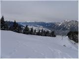
 | Mesnice - Krim (by road)
Krim is a 1,107-metre-high mountain rising south of the Ljubljana Marsh. From the summit, where a mountain hut and several transmitters stand, th...
1 h 50 min |
 | Rakitna - Krim
Krim is a 1,107-metre-high mountain rising south of the Ljubljana Marsh. From the summit, where a mountain hut and several transmitters stand, th...
2 h |
 | Polharski dom Krim - Krim
Krim is a 1,107-metre-high mountain rising south of the Ljubljana Marsh. From the summit, where a mountain hut and several transmitters stand, th...
1 h 35 min |
 | Črnivec - Kranjska reber
Kranjska reber, also known as Vrh Kašne planine (1435 m), is a mountain of volcanic origin. From the summit, which has a registration box with a ...
1 h 30 min |
 | Rateče - Ofen/Peč (footpath)
Peč (also known as Tromeja; in Italian Monte Forno, in German Dreiländereck or Ofen) is a 1508 m high peak located at the tripoint between Sloven...
1 h 40 min |
 | Korensko sedlo - Ofen/Peč
Peč (also known as Tromeja; in Italian Monte Forno, in German Dreiländereck or Ofen) is a 1508 m high peak located at the tripoint between Sloven...
2 h |
 | Rateče - Ofen/Peč (eastern path, past bivouac and on footpath)
Peč (also known as Tromeja; in Italian Monte Forno, in German Dreiländereck or Ofen) is a 1508 m high peak located at the tripoint between Sloven...
1 h 45 min |
| Rateče - Ofen/Peč (eastern path, past bivouac and on mule track)
Peč (also known as Tromeja; in Italian Monte Forno, in German Dreiländereck or Ofen) is a 1508 m high peak located at the tripoint between Sloven...
1 h 50 min |
 | Korensko sedlo - Ofen/Peč (on marked path)
Peč (also known as Tromeja; in Italian Monte Forno, in German Dreiländereck or Ofen) is a 1508 m high peak located at the tripoint between Sloven...
2 h |
 | Javorje - Stari vrh (via Koča na Starem vrhu)
Stari Vrh is a 1,217-metre-high mountain located above the ski resort of the same name. There is no view from the summit itself due to the forest...
1 h 35 min |
 | Javorje - Stari vrh (via Prehodi)
Stari Vrh is a 1,217-metre-high mountain located above the ski resort of the same name. There is no view from the summit itself due to the forest...
1 h 30 min |
 | Eko koča Nanos (Lovska koča Vojkovo) - Vojkova koča na Nanosu
Vojkova koča is located on the southern edge of the high karst Nanos plateau, near Pleša. This is the prominent peak with television transmitters...
1 h 50 min |
 | Furlanovo zavetišče pri Abramu - Vojkova koča na Nanosu
Vojkova koča is located on the southern edge of the high karst Nanos plateau, near Pleša. This is the prominent peak with television transmitters...
2 h |
 | Selo - Pasja ravan (via Ostrež)
Pasja ravan is the second-highest peak in the Polhograjsko hribovje. A few decades ago, at 1029 meters, it was the highest, but in the second hal...
2 h 15 min |
 | Predmeja - Kucelj (on Čaven)
Kucelj is located on the southern slopes of the Trnovski Forest, northwest of the Vipava Valley. From the bare summit, where a cross stands, ther...
2 h |
| Predmeja (tunnels) - Kucelj (on Čaven) (via Koča na Čavnu)
Kucelj is located on the southern slopes of the Trnovski Forest, northwest of the Vipava Valley. From the bare summit, where a cross stands, ther...
2 h 15 min |
 | Krnica - Kucelj (on Čaven) (via Veliki Rob)
Kucelj is located on the southern slopes of the Trnovski Forest, northwest of the Vipava Valley. From the bare summit, where a cross stands, ther...
1 h 40 min |
 | Polomova rajda - Veliki Modrasovec (via Koča na Čavnu)
Veliki Modrasovec is located on the southern part of the Trnovski Forest near Predmeja. On the summit stands an old military building, which we m...
1 h 25 min |
 | Predmeja - Veliki Modrasovec
Veliki Modrasovec is located on the southern part of the Trnovski Forest near Predmeja. On the summit stands an old military building, which we m...
1 h 40 min |
| Predmeja (tunnels) - Veliki Modrasovec
Veliki Modrasovec is located on the southern part of the Trnovski Forest near Predmeja. On the summit stands an old military building, which we m...
1 h 55 min |
 | Bevški vrh - Veliki Modrasovec
Veliki Modrasovec is located on the southern part of the Trnovski Forest near Predmeja. On the summit stands an old military building, which we m...
1 h 40 min |
 | Koča Edmunda Čibeja v Tihi dolini - Mali Golak
Mali Golak is the highest peak in the Golaki group at 1495 meters above sea level and at the same time the highest point of the entire Trnovski g...
2 h |
 | Mala Lazna - Mali Golak
Mali Golak is the highest peak in the Golaki group at 1495 meters above sea level and at the same time the highest point of the entire Trnovski g...
1 h 25 min |
 | Škrbina - Mali Golak
Mali Golak is the highest peak in the Golaki group at 1495 meters above sea level and at the same time the highest point of the entire Trnovski g...
2 h |
| Bevški vrh - Mali Golak
Mali Golak is the highest peak in the Golaki group at 1495 meters above sea level and at the same time the highest point of the entire Trnovski g...
1 h 35 min |
| Predmeja (Gorjanka) - Mali Golak
Mali Golak is the highest peak in the Golaki group at 1495 meters above sea level and at the same time the highest point of the entire Trnovski g...
2 h 25 min |
 | Kozarnice - Srednji Golak (via Mali Golak)
Srednji Golak is located between Mali and Veliki Golak on the plateau of Trnovski gozd above Predmeja. The peak is covered with dwarf pines, and ...
1 h 50 min |
 | Lokve - Poldanovec
Poldanovec is located in Govci, on the northern edge of the Trnovo plateau. Govci rise steeply above the valley of Gorenja Trebuša. Poldanovec is...
1 h 30 min |
 | Turški klanec - Mrzovec
Mržovec is the most prominent peak in the heart of the Trnovo Plateau. Its location offers wonderful views, though high trees obscure them from t...
1 h 30 min |
 | St. John the Baptist on Ojstrica - Huhnerkogel/Košenjak
Košenjak is located north of Dravograd and the Drava River on the border with neighbouring Austria. Access to Košenjak is possible on foot or by ...
1 h 30 min |
| Usek - Huhnerkogel/Košenjak (mimo sv. Urbana)
Košenjak is located north of Dravograd and the Drava River on the border with neighbouring Austria. Access to Košenjak is possible on foot or by ...
2 h |
 | St. John the Baptist on Ojstrica - Huhnerkogel/Košenjak (via Bivak Piramida)
Košenjak is located north of Dravograd and the Drava River on the border with neighbouring Austria. Access to Košenjak is possible on foot or by ...
2 h |
 | Jezero Sobote / Stausee Soboth - Huhnerkogel/Košenjak (on marked path)
Košenjak is located north of Dravograd and the Drava River on the border with neighbouring Austria. Access to Košenjak is possible on foot or by ...
2 h |
 | Avsa - Mrzli vrh (on Matajur) (old path)
Mrzli vrh is a 1358-meter-high peak located in the Matajur range. From the summit, where there is a panorama board and a summit register box with...
1 h 25 min |
 | Planinski dom Vrhe - Črni vrh (Čemšeniška planina)
Črni vrh is the highest peak of Čemšeniška planina and, at 1,204 m, the second-highest peak in Posavsko hribovje. The summit has a logbook box bu...
1 h 30 min |
 | Bučan - Polna peč
Polna peč (also marked as Ravna peč on maps) is situated above the Ljubelj tunnel. From the somewhat precipitous summit there is a nice view of t...
1 h 30 min |
 | Črni Vrh - Javornik (above Črni Vrh) (via Šajsna Ravan)
Javornik is a forested peak located southeast of Črni Vrh. In 1972, a wooden observation tower was built on it, rising above the treetops and off...
2 h 30 min |
| Kampelc - Javornik (above Črni Vrh)
Javornik is a forested peak located southeast of Črni Vrh. In 1972, a wooden observation tower was built on it, rising above the treetops and off...
2 h 15 min |
 | Podkraj - Javornik (above Črni Vrh)
Javornik is a forested peak located southeast of Črni Vrh. In 1972, a wooden observation tower was built on it, rising above the treetops and off...
2 h 30 min |
| Repna dolina - Javornik (above Črni Vrh)
Javornik is a forested peak located southeast of Črni Vrh. In 1972, a wooden observation tower was built on it, rising above the treetops and off...
1 h 45 min |
 | Vodice (Mali Školj) - Javornik (above Črni Vrh)
Javornik is a forested peak located southeast of Črni Vrh. In 1972, a wooden observation tower was built on it, rising above the treetops and off...
1 h 35 min |
 | Kalce - Veliki Javornik (Javorniki)
Veliki Javornik is a 1,268-meter-high peak of the forested hills named Javorniki. The extensive Javorniki forests stretch from Postojna to Cerkni...
1 h 30 min |
 | Pohorje cable car - Žigartov vrh (via Razglednik)
Žigartov vrh, at 1,346 meters, is the highest peak in the eastern part of Pohorje. An "observation" tower once stood on the summit, erected solel...
2 h 15 min |
| Pohorje cable car - Žigartov vrh (via Mariborska koča)
Žigartov vrh, at 1,346 meters, is the highest peak in the eastern part of Pohorje. An "observation" tower once stood on the summit, erected solel...
2 h 20 min |
 | Juršče - Kršičevec
Kršičevec is a lesser-known mountain located east of Jurišče village in the Pivka basin. From its grassy summit, which has a logbook box with a s...
1 h 30 min |
 | Platak - Snježnik (via grlo)
Snježnik is a panoramic mountain in the western part of Gorski Kotar. From the summit there is a beautiful view of the Kvarner islands, Rijeka ba...
1 h 30 min |
| Platak - Snježnik (via crest)
Snježnik is a panoramic mountain in the western part of Gorski Kotar. From the summit there is a beautiful view of the Kvarner islands, Rijeka ba...
1 h 30 min |
 | Zakojca - Kojca
Kojca is a panoramic peak rising south of Baška grapa. From the summit, where there is a haystack, fine views extend over the Lower Bohinj Mounta...
1 h 45 min |
| Jesenica - Kojca
Kojca is a panoramic peak rising south of Baška grapa. From the summit, where there is a haystack, fine views extend over the Lower Bohinj Mounta...
1 h 45 min |
 | Koča na Starem vrhu - Mladi vrh (via Stari vrh)
Mladi vrh is the higher neighbor of the better-known Stari vrh, separated from it by a saddle. Covered in sparse beech forest, the summit offers ...
1 h 40 min |
 | Črni Kal - Mladi vrh (via Koprivnik)
Mladi vrh is the higher neighbor of the better-known Stari vrh, separated from it by a saddle. Covered in sparse beech forest, the summit offers ...
2 h 15 min |
| Preval - Mladi vrh
Mladi vrh is the higher neighbor of the better-known Stari vrh, separated from it by a saddle. Covered in sparse beech forest, the summit offers ...
2 h |
 | Dom planincev Farbanca - Tolsti vrh (Dobrovlje)
Tolsti vrh, together with Šentjoški vrh (1,077 m), is the highest peak of the Dobroveljska planota plateau. From the summit, which has a logbook ...
2 h |
| Lipa - Tolsti vrh (Dobrovlje)
Tolsti vrh, together with Šentjoški vrh (1,077 m), is the highest peak of the Dobroveljska planota plateau. From the summit, which has a logbook ...
1 h 40 min |
 | Zagrad - Medvižica (via Ostrič)
Medvižica is a rocky peak located on the Slovenian side of Čičarija. From the bare summit, there is a beautiful view of the surrounding hills, wi...
1 h 50 min |
| Zagrad - Medvižica (via Razsušica)
Medvižica is a rocky peak located on the Slovenian side of Čičarija. From the bare summit, there is a beautiful view of the surrounding hills, wi...
1 h 45 min |
 | Zagrad - Razsušica (via Ostrič)
Razsušica, at 1083 meters, is the highest peak of Slovenian Istria. Although the summit is partly vegetated, it offers a nice view towards the ne...
2 h 5 min |
 | Črni Vrh - Čelkov vrh
Čelkov vrh is a 1,106-meter peak south of Črni vrh. From the summit, which has a logbook box and stamp, there are fine views toward the Julian Al...
1 h 30 min |
| Podkraj - Srednja gora (Hrušica) (east path)
Srednja gora is a 1,275 m high peak in the central part of forested Hrušica. Although the summit is wooded, just a few minutes' walk east from th...
1 h 30 min |
| Podkraj - Srednja gora (Hrušica) (west path)
Srednja gora is a 1,275 m high peak in the central part of forested Hrušica. Although the summit is wooded, just a few minutes' walk east from th...
1 h 45 min |
 | Podkraj - Streliški vrh (Hrušica) (east path)
Streliški vrh is a 1,266 m high mountain in the central part of forested Hrušica. From the partly forested summit, a nice view opens only to the ...
1 h 30 min |
 | Ravne - Cerk
Cerk, at 1,192 meters, is the highest peak of Borovška gora, a range situated between the Kolpa River valley and Goteniški Snežnik. From the summ...
1 h 30 min |
 | border crossing Remšnik - Kapunar / Kapunerkogel (via Sveti Urban)
Kapunar is a 1,051-meter-high peak above Radlje ob Dravi. Just below the summit stands an old customs post and border guardhouse, now used by ama...
2 h 20 min |
| border crossing Remšnik - Kapunar / Kapunerkogel (Austrian path)
Kapunar is a 1,051-meter-high peak above Radlje ob Dravi. Just below the summit stands an old customs post and border guardhouse, now used by ama...
2 h 5 min |
 | Radeljski prelaz - Kapunar / Kapunerkogel
Kapunar is a 1,051-meter-high peak above Radlje ob Dravi. Just below the summit stands an old customs post and border guardhouse, now used by ama...
1 h 40 min |
| Sveti Jurij (Remšnik) - Kapunar / Kapunerkogel
Kapunar is a 1,051-meter-high peak above Radlje ob Dravi. Just below the summit stands an old customs post and border guardhouse, now used by ama...
2 h |
 | Solarji - Nagnoj
Nagnoj is the second-highest peak of the Kolovrat range at 1193 m. The range lies between Tolmin and Venetian Slovenia. From the summit, which ha...
1 h 40 min |
 | Krn - Mrzli vrh above Planina Pretovč
Mrzli vrh is a well-known battlefield from the First World War. Today, the peak is recognised as an open-air museum where numerous caverns, trenc...
1 h 30 min |
 | Tuškov Grič - Medrce (by road)
Medrce is a 1,410-meter-high peak located between Porezen and Hum. From the summit, which features an old bunker, there are nice views of Kojca, ...
2 h 20 min |
 | Čemernica / Tschemernitzen - Arihova peč / Arichwand
Arihova peč / Arichwand is a panoramic rocky cliff located near the Bleščeča planina / Rossalm pasture. A wooden hut stands on top of the cliff, ...
1 h 25 min |
 | Kuna Konavoska - Ilijin vrh
Ilijin vrh, also known as Sveti Ilija, is the main peak of the Sniježnica Konavoska mountain ridge, which is also the southernmost mountain ridge...
2 h 30 min |
 | St. John the Baptist on Ojstrica - Kozji vrh (at Košenjak)
Kozji vrh is a 1,383-meter-high peak located above Pernice; it is also the highest peak in the Municipality of Muta....
1 h 35 min |
 | Rehabilitation center St. Radegund at Graz - Schöckl (hiking path)
Schöckl, often also spelled Schöckel, is a 1,445-meter-high hill above St. Radegund near Graz and the southernmost of the popular peaks in the Gr...
2 h 15 min |
 | Široko - Veliki vrh (above Lom) (direct way)
Veliki vrh is located on the northeastern part of the Banjška planota plateau, which rises above Čepovani dol, the Soča river valley, and the Idr...
1 h 30 min |
 | Široko - Veliki vrh (above Lom) (via Grudnica - on trail Lom is my home)
Veliki vrh is located on the northeastern part of the Banjška planota plateau, which rises above Čepovani dol, the Soča river valley, and the Idr...
1 h 50 min |
 | Chortata - Egklouvi road - Stavrota (Lefkada)
Stavrota is the highest peak at 1,182 m on the Greek island of Lefkada (also known as Lefkas), which lies in the Ionian Sea. The Greek name of t...
1 h 50 min |
 | Kebelj - Veliki vrh (on Pohorje)
Veliki vrh is a 1344-meter-high peak located above the RTC Jakec - Trije kralji ski slope. The highest point of the peak is in the forest, but ju...
2 h 10 min |
 | Koča na Šumiku - Veliki vrh (on Pohorje)
Veliki vrh is a 1344-meter-high peak located above the RTC Jakec - Trije kralji ski slope. The highest point of the peak is in the forest, but ju...
2 h |
 | Parking Rote Wand (Tyrnau) - Rote Wand (via saddle Bucheben)
Rote Wand is a 1,505-meter-high mountain in the Graz Mountains in Styria, Austria. The name "Rote Wand" (red wall) comes from its southeast-facin...
2 h |
 | Teichalm (Teichalmsee) - Rote Wand (lower path)
Rote Wand is a 1,505-meter-high mountain in the Graz Mountains in Styria, Austria. The name "Rote Wand" (red wall) comes from its southeast-facin...
2 h 15 min |
| Teichalm (Teichalmsee) - Rote Wand (upper path)
Rote Wand is a 1,505-meter-high mountain in the Graz Mountains in Styria, Austria. The name "Rote Wand" (red wall) comes from its southeast-facin...
2 h 15 min |
 | Mönichkirchen - Steinerne Stiege
Steinerne Stiege is a less prominent peak in the Wechsel range....
1 h 35 min |
 | Planinski dom Orlove stine - Svilaja (past Umac)
Svilaja is a 1509-meter grassy peak above Peručko Lake, north of the town of Sinj. The summit features a cross and a concrete pillar. From the to...
2 h |
 | Malovan - Čardak (Tremzina)
Čardak is a peak on Tremzina, a smaller range east of the more famous Crnopac. Tremzina is located at the end of the Southern Velebit. There is a...
2 h |
 | Malovan - Oklinak
Oklinak is the highest peak of Tremzina, a smaller range east of the more famous Crnopac. Tremzina is located at the end of the Southern Velebit....
2 h 30 min |
 | Alpl (Zisleranger Weg) - Teufelstein
Teufelstein is a 1,498-meter-high mountain in the Fischbacher Alpen group. At the summit there is a cross with a summit logbook, and slightly bel...
2 h 20 min |
| Alpl (Waldschulle Alpl) - Teufelstein
Teufelstein is a 1,498-meter-high mountain in the Fischbacher Alpen group. At the summit there is a cross with a summit logbook, and slightly bel...
2 h 30 min |
 | Nechnitz - Gerlerkogel (via Gschaidberg)
Gerlerkogel is a 1324-meter-high peak situated in the Almenland nature park. From the grassy peak, a beautiful view opens up of the surrounding m...
2 h 15 min |
 | Schanzsattel - Stanglalpe
Stanglalpe is a peak in the Fischabacher Alpen mountain group, which lies in the hills east of the Mur. The peak itself is situated beside a road...
2 h 20 min |
 | Račja vas - Orljak (Čičarija)
Orljak is a panoramic peak in Čičarija. The summit features a cross and a logbook. It is a point on the HPO and Istrian mountain trail. From the ...
1 h 30 min |
 | Crossroads below Zvonik - Bitoraj
Bitoraj (also Veliki Bitoraj or Burni Bitoraj) is a 1,386-meter-high peak located south of the settlement Vrata. The peak is an HPO point. From t...
1 h 30 min |
 | Omar - Črni vrh (above Klenovica)
Črni vrh is a distinct peak situated above Klenovica. It is located near the more famous Kolovratske stijene. From the summit, which has a logboo...
1 h 45 min |
 | Kugina kuća - Laktin vrh
Laktin vrh is a panoramic grassy peak in Central Velebit, east of the main ridge. It is a checkpoint for HPO and the Velebit Circuit. From the su...
1 h 30 min |
 | Unternberg - Kampstein
Kampstein is a 1,467-meter-high mountain situated above the settlement of St. Corona am Wechsel. At the summit there is a cross and a few benches...
2 h |
 | St. Corona am Wechsel - Kampstein (past Kampsteiner Schwaig)
Kampstein is a 1,467-meter-high mountain situated above the settlement of St. Corona am Wechsel. At the summit there is a cross and a few benches...
2 h 5 min |