 | Črni Kal - Blegoš (by road, via hut)
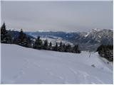
Blegoš is a 1,562-metre-high mountain located between the Selška Sora and Poljanska Sora rivers. From the grassy summit, where there is a stamp a...
1 h 30 min |
 | Črni Kal - Blegoš (direct way)
Blegoš is a 1,562-metre-high mountain located between the Selška Sora and Poljanska Sora rivers. From the grassy summit, where there is a stamp a...
1 h 10 min |
 | Črni kal - Blegoš (via Prva ravan)
Blegoš is a 1,562-metre-high mountain located between the Selška Sora and Poljanska Sora rivers. From the grassy summit, where there is a stamp a...
1 h 20 min |
 | Mesnice - Krim (by road)
Krim is a 1,107-metre-high mountain rising south of the Ljubljana Marsh. From the summit, where a mountain hut and several transmitters stand, th...
1 h 50 min |
 | Rakitna - Krim
Krim is a 1,107-metre-high mountain rising south of the Ljubljana Marsh. From the summit, where a mountain hut and several transmitters stand, th...
2 h |
 | Polharski dom Krim - Krim
Krim is a 1,107-metre-high mountain rising south of the Ljubljana Marsh. From the summit, where a mountain hut and several transmitters stand, th...
1 h 35 min |
 | Radlek - Slivnica
Slivnica is a 1,114-meter-high peak located north of the Cerknica Field and the intermittent Lake Cerknica. The summit itself is quite rounded, p...
1 h 20 min |
 | Volovljek - Kranjska reber
Kranjska reber, also known as Vrh Kašne planine (1435 m), is a mountain of volcanic origin. From the summit, which has a registration box with a ...
1 h 20 min |
 | Črnivec - Kranjska reber
Kranjska reber, also known as Vrh Kašne planine (1435 m), is a mountain of volcanic origin. From the summit, which has a registration box with a ...
1 h 30 min |
 | Rateče - Ofen/Peč (footpath)
Peč (also known as Tromeja; in Italian Monte Forno, in German Dreiländereck or Ofen) is a 1508 m high peak located at the tripoint between Sloven...
1 h 40 min |
 | Korensko sedlo - Ofen/Peč
Peč (also known as Tromeja; in Italian Monte Forno, in German Dreiländereck or Ofen) is a 1508 m high peak located at the tripoint between Sloven...
2 h |
 | Rateče - Ofen/Peč (eastern path, past bivouac and on footpath)
Peč (also known as Tromeja; in Italian Monte Forno, in German Dreiländereck or Ofen) is a 1508 m high peak located at the tripoint between Sloven...
1 h 45 min |
| Rateče - Ofen/Peč (eastern path, past bivouac and on mule track)
Peč (also known as Tromeja; in Italian Monte Forno, in German Dreiländereck or Ofen) is a 1508 m high peak located at the tripoint between Sloven...
1 h 50 min |
 | Korensko sedlo - Ofen/Peč (on marked path)
Peč (also known as Tromeja; in Italian Monte Forno, in German Dreiländereck or Ofen) is a 1508 m high peak located at the tripoint between Sloven...
2 h |
 | Dom pod Storžičem - Bela peč
The mountain, known mainly among climbers, is located north of Storžič on the slopes of Konjščica. From the summit there is a beautiful view of t...
2 h |
| Dom pod Storžičem - Bela peč (via Javorniški preval)
The mountain, known mainly among climbers, is located north of Storžič on the slopes of Konjščica. From the summit there is a beautiful view of t...
2 h 5 min |
 | Na kopiš - Bela peč (via Spodnja and Zgornja Konjščica)
The mountain, known mainly among climbers, is located north of Storžič on the slopes of Konjščica. From the summit there is a beautiful view of t...
2 h |
 | Javorje - Stari vrh (via Koča na Starem vrhu)
Stari Vrh is a 1,217-metre-high mountain located above the ski resort of the same name. There is no view from the summit itself due to the forest...
1 h 35 min |
 | Javorje - Stari vrh (via Prehodi)
Stari Vrh is a 1,217-metre-high mountain located above the ski resort of the same name. There is no view from the summit itself due to the forest...
1 h 30 min |
 | Zgornja Sorica - Dravh
Dravh is a 1,547-metre-high peak situated between Sorica and Soriška Planina. From the unforested summit a beautiful view opens across the Škofja...
1 h 30 min |
 | Zgornja Sorica - Lajnar
Lajnar is a 1,549-metre-high mountain located north of Soriška Planina. From the summit, which is also the highest point of the ski resort, a bea...
1 h 40 min |
 | Eko koča Nanos (Lovska koča Vojkovo) - Vojkova koča na Nanosu
Vojkova koča is located on the southern edge of the high karst Nanos plateau, near Pleša. This is the prominent peak with television transmitters...
1 h 50 min |
 | Furlanovo zavetišče pri Abramu - Vojkova koča na Nanosu
Vojkova koča is located on the southern edge of the high karst Nanos plateau, near Pleša. This is the prominent peak with television transmitters...
2 h |
 | Krnica - Kucelj (on Čaven) (via Veliki Rob)
Kucelj is located on the southern slopes of the Trnovski Forest, northwest of the Vipava Valley. From the bare summit, where a cross stands, ther...
1 h 40 min |
 | Koča Edmunda Čibeja v Tihi dolini - Mali Golak
Mali Golak is the highest peak in the Golaki group at 1495 meters above sea level and at the same time the highest point of the entire Trnovski g...
2 h |
 | Mala Lazna - Mali Golak
Mali Golak is the highest peak in the Golaki group at 1495 meters above sea level and at the same time the highest point of the entire Trnovski g...
1 h 25 min |
| Bevški vrh - Mali Golak
Mali Golak is the highest peak in the Golaki group at 1495 meters above sea level and at the same time the highest point of the entire Trnovski g...
1 h 35 min |
 | Brneško sedlo - Velika Kopa
Velika Kopa is a 1542-meter-high peak located between Grmovškov dom and the nearby Mala Kopa. From the top, which is only 1 meter lower than the ...
1 h 50 min |
| Koča Planinc - Velika Kopa
Velika Kopa is a 1542-meter-high peak located between Grmovškov dom and the nearby Mala Kopa. From the top, which is only 1 meter lower than the ...
1 h 50 min |
 | Kupljenik - Babji zob
Babji zob is a viewpoint above the village of Kupljenik near Bled. The precipitous peak, which has a registration box, offers a beautiful view of...
1 h 30 min |
 | Kozarnice - Srednji Golak (via Mali Golak)
Srednji Golak is located between Mali and Veliki Golak on the plateau of Trnovski gozd above Predmeja. The peak is covered with dwarf pines, and ...
1 h 50 min |
 | Lokve - Poldanovec
Poldanovec is located in Govci, on the northern edge of the Trnovo plateau. Govci rise steeply above the valley of Gorenja Trebuša. Poldanovec is...
1 h 30 min |
 | Turški klanec - Mrzovec
Mržovec is the most prominent peak in the heart of the Trnovo Plateau. Its location offers wonderful views, though high trees obscure them from t...
1 h 30 min |
 | Podmeja - Mrzlica
In recent years, Mrzlica has become an extremely popular excursion spot, especially for visitors from Savinjska valley and Zasavje. At 1,122 mete...
1 h 15 min |
 | Podmeja - Mrzlica
In recent years, Mrzlica has become an extremely popular excursion spot, especially for visitors from Savinjska valley and Zasavje. At 1,122 mete...
1 h 15 min |
 | Dom na Paškem Kozjaku - Basališče (Paški Kozjak)
Basališče is the highest peak of Paški Kozjak. A bench and a summit register have been placed on the summit. However, due to the forest, there is...
2 h |
 | St. John the Baptist on Ojstrica - Huhnerkogel/Košenjak
Košenjak is located north of Dravograd and the Drava River on the border with neighbouring Austria. Access to Košenjak is possible on foot or by ...
1 h 30 min |
 | St. John the Baptist on Ojstrica - Huhnerkogel/Košenjak (via Bivak Piramida)
Košenjak is located north of Dravograd and the Drava River on the border with neighbouring Austria. Access to Košenjak is possible on foot or by ...
2 h |
 | Jezero Sobote / Stausee Soboth - Huhnerkogel/Košenjak (on marked path)
Košenjak is located north of Dravograd and the Drava River on the border with neighbouring Austria. Access to Košenjak is possible on foot or by ...
2 h |
 | Avsa - Mrzli vrh (on Matajur) (old path)
Mrzli vrh is a 1358-meter-high peak located in the Matajur range. From the summit, where there is a panorama board and a summit register box with...
1 h 25 min |
 | Plajberški graben / Bleiberger Graben - Sinacher Gupf / Psinski vrh
Sinski vrh (mostly marked as Psinski vrh on maps) / Sinacher Gupf is a peak north of the main Karawanks ridge, more precisely north of Stol and V...
1 h 35 min |
 | Strugarjach / Strugarje - Sinacher Gupf / Psinski vrh
Sinski vrh (mostly marked as Psinski vrh on maps) / Sinacher Gupf is a peak north of the main Karawanks ridge, more precisely north of Stol and V...
1 h 30 min |
 | Čemšenik - Črni vrh (Čemšeniška planina)
Črni vrh is the highest peak of Čemšeniška planina and, at 1,204 m, the second-highest peak in Posavsko hribovje. The summit has a logbook box bu...
1 h 30 min |
 | Planinski dom Vrhe - Črni vrh (Čemšeniška planina)
Črni vrh is the highest peak of Čemšeniška planina and, at 1,204 m, the second-highest peak in Posavsko hribovje. The summit has a logbook box bu...
1 h 30 min |
 | Ljubelj - Polna peč
Polna peč (also marked as Ravna peč on maps) is situated above the Ljubelj tunnel. From the somewhat precipitous summit there is a nice view of t...
1 h 15 min |
 | Bučan - Polna peč
Polna peč (also marked as Ravna peč on maps) is situated above the Ljubelj tunnel. From the somewhat precipitous summit there is a nice view of t...
1 h 30 min |
 | Vlačno - Sveta Trojica
Sveta Trojica is a distinctly panoramic 1106-meter peak located southwest of the Javorniki. From the summit, where a beautifully restored histori...
1 h 20 min |
 | Črni Vrh (Grom) - Javornik (above Črni Vrh)
Javornik is a forested peak located southeast of Črni Vrh. In 1972, a wooden observation tower was built on it, rising above the treetops and off...
1 h 15 min |
 | Repna dolina - Javornik (above Črni Vrh)
Javornik is a forested peak located southeast of Črni Vrh. In 1972, a wooden observation tower was built on it, rising above the treetops and off...
1 h 45 min |
 | Vodice (Mali Školj) - Javornik (above Črni Vrh)
Javornik is a forested peak located southeast of Črni Vrh. In 1972, a wooden observation tower was built on it, rising above the treetops and off...
1 h 35 min |
 | Kalce - Veliki Javornik (Javorniki)
Veliki Javornik is a 1,268-meter-high peak of the forested hills named Javorniki. The extensive Javorniki forests stretch from Postojna to Cerkni...
1 h 30 min |
 | Hunting cottage Gozdnik - Gozdnik
Gozdnik is a hill that rises steeply above the village of Zabukovica. There is no view from the summit due to the forest, but a bivouac has been ...
1 h 10 min |
 | Zagreben (pri Dikcu) - Gozdnik
Gozdnik is a hill that rises steeply above the village of Zabukovica. There is no view from the summit due to the forest, but a bivouac has been ...
1 h 30 min |
 | Mala Učka - Vojak
Vojak, at 1401 m, is the highest peak of Učka, a range rising steeply above the eastern Istrian coast. From the summit, which features a stone ob...
1 h 15 min |
 | Juršče - Kršičevec
Kršičevec is a lesser-known mountain located east of Jurišče village in the Pivka basin. From its grassy summit, which has a logbook box with a s...
1 h 30 min |
 | Platak - Snježnik (via grlo)
Snježnik is a panoramic mountain in the western part of Gorski Kotar. From the summit there is a beautiful view of the Kvarner islands, Rijeka ba...
1 h 30 min |
| Platak - Snježnik (via crest)
Snježnik is a panoramic mountain in the western part of Gorski Kotar. From the summit there is a beautiful view of the Kvarner islands, Rijeka ba...
1 h 30 min |
 | Preval Vrh Ravni - Kojca
Kojca is a panoramic peak rising south of Baška grapa. From the summit, where there is a haystack, fine views extend over the Lower Bohinj Mounta...
1 h 20 min |
 | Zakojca - Kojca
Kojca is a panoramic peak rising south of Baška grapa. From the summit, where there is a haystack, fine views extend over the Lower Bohinj Mounta...
1 h 45 min |
| Jesenica - Kojca
Kojca is a panoramic peak rising south of Baška grapa. From the summit, where there is a haystack, fine views extend over the Lower Bohinj Mounta...
1 h 45 min |
 | Koča na Starem vrhu - Mladi vrh (via Stari vrh)
Mladi vrh is the higher neighbor of the better-known Stari vrh, separated from it by a saddle. Covered in sparse beech forest, the summit offers ...
1 h 40 min |
 | Preval - Mladi vrh
Mladi vrh is the higher neighbor of the better-known Stari vrh, separated from it by a saddle. Covered in sparse beech forest, the summit offers ...
2 h |
 | Zagrad - Razsušica (via Ostrič)
Razsušica, at 1083 meters, is the highest peak of Slovenian Istria. Although the summit is partly vegetated, it offers a nice view towards the ne...
2 h 5 min |
 | Črni Vrh - Čelkov vrh
Čelkov vrh is a 1,106-meter peak south of Črni vrh. From the summit, which has a logbook box and stamp, there are fine views toward the Julian Al...
1 h 30 min |
 | Zadlog - Špičasti vrh
Špičasti vrh is a forest-covered mountain located south of the village of Zadlog. To ensure the summit is not without a view, a 13-meter-high woo...
1 h 15 min |
 | Podkraj - Križna gora (Hrušica) (gentle path)
Križna gora is a 1162 m high peak located north of the village Podkraj. From the summit, where a lookout tower stands, there are fine views over ...
1 h 20 min |
 | Podkraj - Sveti Duh (Hrušica)
The Church of the Holy Spirit is located just a few meters below the summit of Sveti Duh on the slopes of the forested Hrušica, in the range betw...
1 h 15 min |
 | Koča na planini Stador - Kobilja glava
Kobilja glava is a 1,475-meter-high peak located east of Tolmin. From the summit, where a cross stands, there is a beautiful view of Krn, the ran...
1 h 15 min |
| Podkraj - Srednja gora (Hrušica) (east path)
Srednja gora is a 1,275 m high peak in the central part of forested Hrušica. Although the summit is wooded, just a few minutes' walk east from th...
1 h 30 min |
| Podkraj - Srednja gora (Hrušica) (west path)
Srednja gora is a 1,275 m high peak in the central part of forested Hrušica. Although the summit is wooded, just a few minutes' walk east from th...
1 h 45 min |
 | Podkraj - Streliški vrh (Hrušica) (east path)
Streliški vrh is a 1,266 m high mountain in the central part of forested Hrušica. From the partly forested summit, a nice view opens only to the ...
1 h 30 min |
| Podkraj - Streliški vrh (Hrušica) (west path)
Streliški vrh is a 1,266 m high mountain in the central part of forested Hrušica. From the partly forested summit, a nice view opens only to the ...
1 h 20 min |
 | Ravne - Cerk
Cerk, at 1,192 meters, is the highest peak of Borovška gora, a range situated between the Kolpa River valley and Goteniški Snežnik. From the summ...
1 h 30 min |
 | Jeršiče - Mali Javornik (Javorniki)
Mali Javornik is a 1219 m high mountain located in the forested ridge of Javorniki. There is no view from the summit itself due to the forest, bu...
1 h 50 min |
 | Solarji - Nagnoj
Nagnoj is the second-highest peak of the Kolovrat range at 1193 m. The range lies between Tolmin and Venetian Slovenia. From the summit, which ha...
1 h 40 min |
 | Krn - Mrzli vrh above Planina Pretovč
Mrzli vrh is a well-known battlefield from the First World War. Today, the peak is recognised as an open-air museum where numerous caverns, trenc...
1 h 30 min |
 | Raspet - Kopa (Cimprovka)
Kopa is a 1360 m high peak or panoramic promontory from which a nice view opens up on Cerkno, the hills surrounding it, Ratitovec, Trnovski gozd,...
1 h 10 min |
 | Dom na Paškem Kozjaku - Štrukljev vrh
Štrukljev vrh is, alongside Špik (1,108 m) and Basališče (1,272 m), one of the three main peaks of Paški Kozjak, a roughly 10 km long, narrow and...
1 h 30 min |
 | Čemernica / Tschemernitzen - Arihova peč / Arichwand
Arihova peč / Arichwand is a panoramic rocky cliff located near the Bleščeča planina / Rossalm pasture. A wooden hut stands on top of the cliff, ...
1 h 25 min |
 | Avsa - Srednji vrh (on Matajur) (old path)
Srednji vrh is a 1,320-meter-high grassy peak located in the Matajur mountain range. From the summit, a paragliding takeoff point, there is a fin...
1 h 20 min |
 | St. John the Baptist on Ojstrica - Kozji vrh (at Košenjak)
Kozji vrh is a 1,383-meter-high peak located above Pernice; it is also the highest peak in the Municipality of Muta....
1 h 35 min |
 | Chortata - Egklouvi road - Stavrota (Lefkada)
Stavrota is the highest peak at 1,182 m on the Greek island of Lefkada (also known as Lefkas), which lies in the Ionian Sea. The Greek name of t...
1 h 50 min |
 | Kebelj - Veliki vrh (on Pohorje)
Veliki vrh is a 1344-meter-high peak located above the RTC Jakec - Trije kralji ski slope. The highest point of the peak is in the forest, but ju...
2 h 10 min |
 | Koča na Šumiku - Veliki vrh (on Pohorje)
Veliki vrh is a 1344-meter-high peak located above the RTC Jakec - Trije kralji ski slope. The highest point of the peak is in the forest, but ju...
2 h |
 | Parking Rote Wand (Tyrnau) - Rote Wand (via saddle Bucheben)
Rote Wand is a 1,505-meter-high mountain in the Graz Mountains in Styria, Austria. The name "Rote Wand" (red wall) comes from its southeast-facin...
2 h |
 | Mönichkirchen - Steinerne Stiege
Steinerne Stiege is a less prominent peak in the Wechsel range....
1 h 35 min |
 | St. Vinzenz (St. Vinzenz) - Dreieckkogel
Dreieckkogel is a 1,528-meter-high peak in the Golica/Koralpe range, north of Sobota Lake/Stausee Soboth. At the summit there is a cairn with a s...
1 h 35 min |
 | Planinski dom Orlove stine - Svilaja (past Umac)
Svilaja is a 1509-meter grassy peak above Peručko Lake, north of the town of Sinj. The summit features a cross and a concrete pillar. From the to...
2 h |
 | Lišnjak (road on Promina) - Čavnovka (Promina) (past hut and on footpath)
Čavnovka is the highest summit of Promina, a smaller range above the town of Drniš. There are two summits: the southern one features an antenna, ...
1 h 45 min |
 | Lišnjak (road on Promina) - Čavnovka (Promina) (past hut and on road)
Čavnovka is the highest summit of Promina, a smaller range above the town of Drniš. There are two summits: the southern one features an antenna, ...
1 h 45 min |
 | Malovan - Čardak (Tremzina)
Čardak is a peak on Tremzina, a smaller range east of the more famous Crnopac. Tremzina is located at the end of the Southern Velebit. There is a...
2 h |
 | Brandlucken - Plankogel
Plankogel is a 1531-meter-high mountain situated in the Almenland nature park. From the panoramic summit, where a cross stands, a beautiful view ...
2 h |
 | Račja vas - Orljak (Čičarija)
Orljak is a panoramic peak in Čičarija. The summit features a cross and a logbook. It is a point on the HPO and Istrian mountain trail. From the ...
1 h 30 min |
 | Crossroads below Zvonik - Bitoraj
Bitoraj (also Veliki Bitoraj or Burni Bitoraj) is a 1,386-meter-high peak located south of the settlement Vrata. The peak is an HPO point. From t...
1 h 30 min |
 | Omar - Črni vrh (above Klenovica)
Črni vrh is a distinct peak situated above Klenovica. It is located near the more famous Kolovratske stijene. From the summit, which has a logboo...
1 h 45 min |
 | Unternberg - Kampstein
Kampstein is a 1,467-meter-high mountain situated above the settlement of St. Corona am Wechsel. At the summit there is a cross and a few benches...
2 h |
 | St. Corona am Wechsel - Kampstein (past Kampsteiner Schwaig)
Kampstein is a 1,467-meter-high mountain situated above the settlement of St. Corona am Wechsel. At the summit there is a cross and a few benches...
2 h 5 min |
 | Mala Učka - Suhi vrh (Učka)
Suhi vrh is a forested peak located south of the better-known Vojak. At the highest point of the peak there are rocks; slightly further south is ...
1 h 15 min |