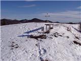
 | Topol - Polhograjska Grmada
Polhograjska Grmada is an 898 m high peak located in the heart of the Polhograjski Dolomites. From the summit, where there is a registration box ...
1 h 15 min |
 | Polhov Gradec (Božna) - Polhograjska Grmada (via Setnica)
Polhograjska Grmada is an 898 m high peak located in the heart of the Polhograjski Dolomites. From the summit, where there is a registration box ...
1 h 30 min |
 | Polhov Gradec (Božna) - Polhograjska Grmada (via Mačkov graben)
Polhograjska Grmada is an 898 m high peak located in the heart of the Polhograjski Dolomites. From the summit, where there is a registration box ...
1 h 30 min |
 | Trnovec - Polhograjska Grmada
Polhograjska Grmada is an 898 m high peak located in the heart of the Polhograjski Dolomites. From the summit, where there is a registration box ...
1 h 15 min |
 | Legastja - Sveti Jakob
The Church of St. James is located on a scenic hill north of the village of Topol pri Medvodah. From the summit, which features a registration bo...
1 h 10 min |
 | Legastja - Sveti Jakob (north path)
The Church of St. James is located on a scenic hill north of the village of Topol pri Medvodah. From the summit, which features a registration bo...
1 h |
 | Selo - Tošč
Tošč, which became the highest peak of the Polhov Gradec Hills decades ago when the Yugoslav army lowered Pasja ravan by 9 metres, is located nor...
1 h |
 | Trnovec - Tošč
Tošč, which became the highest peak of the Polhov Gradec Hills decades ago when the Yugoslav army lowered Pasja ravan by 9 metres, is located nor...
1 h 35 min |
 | Gabrovo - Lubnik
Lubnik is a 1025 m high mountain that rises steeply west of Škofja Loka. From the summit, where a mountain hut stands, there is a beautiful view ...
1 h 30 min |
 | Tičnica - Sveti Jošt above Kranj (Pot prijateljev Sv. Jošta, on stairs)
Sveti Jošt above Kranj is a hill located west of the slightly lower Šmarjetna gora. From the summit, where the Church of St Jošt stands alongside...
1 h 15 min |
| Tičnica - Sveti Jošt above Kranj (Pot prijateljev Sv. Jošta, na klopca)
Sveti Jošt above Kranj is a hill located west of the slightly lower Šmarjetna gora. From the summit, where the Church of St Jošt stands alongside...
1 h 15 min |
| Tičnica - Sveti Jošt above Kranj (Pot prijateljev Sv. Jošta, past the chapel)
Sveti Jošt above Kranj is a hill located west of the slightly lower Šmarjetna gora. From the summit, where the Church of St Jošt stands alongside...
1 h 20 min |
 | Krače - Zasavska Sveta gora
Zasavska Sveta Gora is a popular excursion destination located between Litija and Izlake. From the summit, where the parish church of the Nativit...
1 h 15 min |
 | Cerknica - Slivnica
Slivnica is a 1,114-meter-high peak located north of the Cerknica Field and the intermittent Lake Cerknica. The summit itself is quite rounded, p...
1 h 40 min |
 | Zalog - Polhograjska Gora (Sveti Lovrenc) (gentle path)
Polhograjska Gora, also known simply as Gora or Sveti Lovrenc, is an 824 m high hill northwest of Polhov Gradec. The summit, topped by the Church...
1 h 30 min |
 | Potoki - Ajdna
Ajdna is a peak with a nice view towards Stol, Jelovica, Pokljuka, and the Julian Alps. There is also a good view of part of the Upper Sava Valle...
1 h |
 | Koroška Bela - Ajdna
Ajdna is a peak with a nice view towards Stol, Jelovica, Pokljuka, and the Julian Alps. There is also a good view of part of the Upper Sava Valle...
1 h 30 min |
 | Kupljenik - Babji zob
Babji zob is a viewpoint above the village of Kupljenik near Bled. The precipitous peak, which has a registration box, offers a beautiful view of...
1 h 30 min |
 | Moškrin - Archangel Gabriel (Planica)
Planica is an 824-meter-high peak located north of Škofja Loka, more precisely between Križna gora and Planica. From the summit, where the church...
1 h 30 min |
 | Pevno - Archangel Gabriel (Planica)
Planica is an 824-meter-high peak located north of Škofja Loka, more precisely between Križna gora and Planica. From the summit, where the church...
1 h 30 min |
 | Volče - Vremščica
Vremščica is a mountain range stretching between Senožeče, Pivka and Divača. Its highest peak is Velika Vremščica. The view from the summit exten...
1 h 30 min |
 | Gornje Ležeče - Vremščica
Vremščica is a mountain range stretching between Senožeče, Pivka and Divača. Its highest peak is Velika Vremščica. The view from the summit exten...
1 h 40 min |
 | Loščica - Vremščica
Vremščica is a mountain range stretching between Senožeče, Pivka and Divača. Its highest peak is Velika Vremščica. The view from the summit exten...
1 h 15 min |
 | Rovte - Vrh Svetih Treh Kraljev (steep path)
The Church of the Holy Three Kings stands on a panoramic hill above the village of Vrh Svetih Treh Kraljev. The summit features a panorama board ...
1 h 25 min |
| Rovte - Vrh Svetih Treh Kraljev (gentle path)
The Church of the Holy Three Kings stands on a panoramic hill above the village of Vrh Svetih Treh Kraljev. The summit features a panorama board ...
1 h 30 min |
 | Podmeja - Mrzlica
In recent years, Mrzlica has become an extremely popular excursion spot, especially for visitors from Savinjska valley and Zasavje. At 1,122 mete...
1 h 15 min |
 | Podmeja - Mrzlica
In recent years, Mrzlica has become an extremely popular excursion spot, especially for visitors from Savinjska valley and Zasavje. At 1,122 mete...
1 h 15 min |
 | Hotovlja - Bukov vrh (footpath)
Bukov vrh, where the Church of Our Lady of Sorrows stands, is located in the northwestern part of Polhograjsko hribovje. From the summit, there a...
1 h |
 | Podgorje - Slavnik (steep path)
Slavnik is a panoramic mountain rising south of Kozina and west of Podgorje. Podgorje is a suitable starting village for the ascent. At the summ...
1 h 20 min |
| Podgorje - Slavnik (gentle path)
Slavnik is a panoramic mountain rising south of Kozina and west of Podgorje. Podgorje is a suitable starting village for the ascent. At the summ...
1 h 40 min |
 | Skadanščina - Slavnik
Slavnik is a panoramic mountain rising south of Kozina and west of Podgorje. Podgorje is a suitable starting village for the ascent. At the summ...
1 h 40 min |
 | Begunje - Velika Špička (via Cemarovnik)
Velika Špička or Špičasto Stražišče is a peak located north of Slivnica. From the summit, which has a logbook box with a stamp, there is a nice v...
1 h |
 | Begunje - Velika Špička
Velika Špička or Špičasto Stražišče is a peak located north of Slivnica. From the summit, which has a logbook box with a stamp, there is a nice v...
1 h |
 | Studeno - Gora (Sveti Lovrenc)
Gora, or Sveti Lovrenc, is a peak above Studeno, a village north of Postojna that serves as a suitable starting point for the ascent to this pano...
1 h 5 min |
 | Gorenje - Gora (Sveti Lovrenc)
Gora, or Sveti Lovrenc, is a peak above Studeno, a village north of Postojna that serves as a suitable starting point for the ascent to this pano...
1 h 15 min |
 | Vlačno - Sveta Trojica
Sveta Trojica is a distinctly panoramic 1106-meter peak located southwest of the Javorniki. From the summit, where a beautifully restored histori...
1 h 20 min |
 | Jablanica - Srednji vrh at Kozlek
Srednji vrh pri Kozleku is a panoramic peak located west of Ilirska Bistrica, near the better-known Kozlek. From the summit, there is a beautiful...
1 h 25 min |
 | Sovodenj - Bevkov vrh (steep way)
Bevkov vrh, a control point on the Slovenian Mountain Trail, is located between Cerkno and Spodnja Idrija. The peak is forested, but the stamp is...
1 h 15 min |
| Sovodenj - Bevkov vrh (gentle path)
Bevkov vrh, a control point on the Slovenian Mountain Trail, is located between Cerkno and Spodnja Idrija. The peak is forested, but the stamp is...
1 h 30 min |
 | Jazne (Lanišar) - Sivka
Sivka is a forested peak located west of Žiri and north of Idrija. At the summit there is a stamp for the Slovenian Mountain Trail and a logbook ...
1 h 30 min |
 | Ledinsko Razpotje - Sivka
Sivka is a forested peak located west of Žiri and north of Idrija. At the summit there is a stamp for the Slovenian Mountain Trail and a logbook ...
1 h 15 min |
| Govejk - Sivka
Sivka is a forested peak located west of Žiri and north of Idrija. At the summit there is a stamp for the Slovenian Mountain Trail and a logbook ...
1 h 40 min |
 | Matke - Golava
Golava is a peak located north of Mrzlica. From the summit, where there is a small bivouac (Blažev bivak), there is a fine view toward the aforem...
1 h 15 min |
 | Hunting cottage Gozdnik - Gozdnik
Gozdnik is a hill that rises steeply above the village of Zabukovica. There is no view from the summit due to the forest, but a bivouac has been ...
1 h 10 min |
 | Zagreben (pri Dikcu) - Gozdnik
Gozdnik is a hill that rises steeply above the village of Zabukovica. There is no view from the summit due to the forest, but a bivouac has been ...
1 h 30 min |
 | Zagreben (pri Dikcu) - Malič
Malič is a 936-meter-high peak situated between Celje and Laško, more precisely above Spodnja Rečica. From the summit, which has a transmitter, b...
1 h 30 min |
 | Kamna Gora - Stolpnik
Stolpnik, at 1012 meters, is the highest peak of Konjiška gora, a range stretching southwest from Slovenske Konjice. A 25-meter-high observation ...
1 h |
 | Čretvež - Stolpnik (via Grofov štant)
Stolpnik, at 1012 meters, is the highest peak of Konjiška gora, a range stretching southwest from Slovenske Konjice. A 25-meter-high observation ...
1 h 35 min |
 | Čretvež - Stolpnik (via Hunting cottage Štepih)
Stolpnik, at 1012 meters, is the highest peak of Konjiška gora, a range stretching southwest from Slovenske Konjice. A 25-meter-high observation ...
1 h 25 min |
 | Črešnjice - Stolpnik
Stolpnik, at 1012 meters, is the highest peak of Konjiška gora, a range stretching southwest from Slovenske Konjice. A 25-meter-high observation ...
1 h 25 min |
 | Stara Žaga - Skalica (Bohor) (via Možnica)
Skalica is a lesser-known peak on the western part of Bohor. From the summit, which has a logbook box, there is a nice view to the south and west...
1 h 40 min |
 | Jablance - Koprivnik (Bohor)
Koprivnik, or Veliki Koprivnik, is one of numerous peaks on Bohor. It is located between Koča na Bohorju and Veliki Javornik. From the summit, wh...
1 h 20 min |
 | Šentvid pri Planini - Koprivnik (Bohor)
Koprivnik, or Veliki Koprivnik, is one of numerous peaks on Bohor. It is located between Koča na Bohorju and Veliki Javornik. From the summit, wh...
1 h 30 min |
 | Mrzle doline - Sveti Peter
Sveti Peter is a partly forested peak in Suha Krajina above the village of Dvor. On the summit stands a small shelter (usually open on Sundays) a...
1 h 15 min |
 | Juršče - Kršičevec
Kršičevec is a lesser-known mountain located east of Jurišče village in the Pivka basin. From its grassy summit, which has a logbook box with a s...
1 h 30 min |
 | Nova Štifta - Koča na Kamnem griču
The Koča na Kamnem griču mountain hut is located on Kamni grič, a panoramic hill rising southwest of Sodražica. From the grassy summit surrounded...
1 h 35 min |
 | Žlebe - Rog (via Turnice)
Rog is an 798-meter peak above the village of Topol, just 10 minutes from St. Katarina's Church. From the summit, where a large cross once stood,...
1 h 30 min |
| Žlebe - Rog (via Jeterbenk)
Rog is an 798-meter peak above the village of Topol, just 10 minutes from St. Katarina's Church. From the summit, where a large cross once stood,...
1 h 40 min |
 | Legastja - Rog
Rog is an 798-meter peak above the village of Topol, just 10 minutes from St. Katarina's Church. From the summit, where a large cross once stood,...
1 h 15 min |
 | Tržič - Kamnek (Radetzky way)
Kamnek (Kamnik on maps, also sometimes Kamnjek) is a panoramic peak above Tržič....
1 h |
 | Bločice - Križna gora
Križna gora is a partly panoramic peak located above the villages of Sveta Ana and Podlož. From the summit, where the Church of the Holy Cross st...
1 h 15 min |
 | Lipa - Tolsti vrh (Dobrovlje)
Tolsti vrh, together with Šentjoški vrh (1,077 m), is the highest peak of the Dobroveljska planota plateau. From the summit, which has a logbook ...
1 h 40 min |
 | Sovodenj - Ermanovec (through Miklavževa grapa)
Ermanovec is a 1,026-meter-high peak situated between Cerkno and Gorenja vas, more precisely above Sovodenj and Trebija. Just a few steps from th...
1 h 40 min |
 | Kopačnica - Ermanovec
Ermanovec is a 1,026-meter-high peak situated between Cerkno and Gorenja vas, more precisely above Sovodenj and Trebija. Just a few steps from th...
1 h 40 min |
 | Sovodenj - Ermanovec (by road)
Ermanovec is a 1,026-meter-high peak situated between Cerkno and Gorenja vas, more precisely above Sovodenj and Trebija. Just a few steps from th...
1 h 40 min |
 | Selca - Miklavška gora (footpath)
Miklavška gora is a panoramic hill situated south of Železniki and Selca. From the summit, where the Church of St. Nicholas stands, a beautiful v...
1 h 25 min |
 | Podgora - Kamen vrh
Kamen Vrh is a panoramic hill located on the northern edge of Mala Gora. From the summit, surrounded by low bushes, there are fine views of parts...
1 h |
 | Podgora - Grmada on Mala gora
Grmada (also Grmada above Ortnek) is an 887-meter-high peak located above the village of Vrh pri Poljanah in the Mala Gora range. Just a few mete...
1 h 20 min |
 | Ortnek - Grmada on Mala gora
Grmada (also Grmada above Ortnek) is an 887-meter-high peak located above the village of Vrh pri Poljanah in the Mala Gora range. Just a few mete...
1 h |
 | Steljnik - Stene svete Ane
Stene Svete Ane is a vegetated peak located near the Planinska Koča pri Sveti Ani on Mala Gora. A small observation tower stands on the summit, e...
1 h 20 min |
| Seljan - Stene svete Ane (gentle path)
Stene Svete Ane is a vegetated peak located near the Planinska Koča pri Sveti Ani on Mala Gora. A small observation tower stands on the summit, e...
1 h 5 min |
 | Ribnica (Lepovče) - Stene svete Ane
Stene Svete Ane is a vegetated peak located near the Planinska Koča pri Sveti Ani on Mala Gora. A small observation tower stands on the summit, e...
1 h 35 min |
 | Gotenica - Kameni zid
Kameni zid consists of steep rocky cliffs descending sharply from Goteniška gora. From the top of Kameni zid, fine views open towards Stojna, Koč...
1 h 30 min |
 | Suhi Dol - Sivka (through forest)
Sivka is a grassy peak at the far western end of Polhograjsko hribovje. On clear days, it offers breathtaking views from Snežnik across Javorniki...
1 h 30 min |
 | Col - Kovk
Kovk is a panoramic peak west of Col on an elongated ridge rising steeply above the Vipava Valley. From the summit cross, beautiful views extend ...
1 h |
 | Hunting cottage Budanje - Kovk
Kovk is a panoramic peak west of Col on an elongated ridge rising steeply above the Vipava Valley. From the summit cross, beautiful views extend ...
1 h 30 min |
 | Črni Vrh - Čelkov vrh
Čelkov vrh is a 1,106-meter peak south of Črni vrh. From the summit, which has a logbook box and stamp, there are fine views toward the Julian Al...
1 h 30 min |
 | Zadlog - Špičasti vrh
Špičasti vrh is a forest-covered mountain located south of the village of Zadlog. To ensure the summit is not without a view, a 13-meter-high woo...
1 h 15 min |
 | Kočevje - Fridrihštajn Castle (Grajska way)
Fridrihštajn Castle, built in the 15th century, is located south of Kočevje on a 970 m high hill. Today only ruins remain, which have been renova...
1 h 30 min |
 | Veliki Boč (Zgornji Kovač) - Žavcarjev vrh
Žavcarjev vrh is a 915 m high mountain located north of the Drava River on the slopes of Kozjak. Since the summit is completely forested, there i...
1 h 25 min |
 | Podmeja - Sveta planina (Partizanski vrh)
Sveta planina, also Partizanski vrh, is a 1,011-meter-high mountain located between Čemšeniška planina and Mrzlica. From the summit, where there ...
1 h 30 min |
 | Potoška vas - Sveta planina (Partizanski vrh)
Sveta planina, also Partizanski vrh, is a 1,011-meter-high mountain located between Čemšeniška planina and Mrzlica. From the summit, where there ...
1 h 30 min |
 | Brest - Žbevnica (gentle path)
Žbevnica is a 1,014-meter-high peak situated above the village of Brest, on the Slovenian-Croatian border. From the summit, a beautiful view open...
1 h |
 | Podbrdo - Kup
Kup is a 1,046-meter-high peak located between Petrovo Brdo and Podbrdo. From the summit, which features a cross and several transmitters, there ...
1 h 35 min |
 | Radeljski prelaz - Kapunar / Kapunerkogel
Kapunar is a 1,051-meter-high peak above Radlje ob Dravi. Just below the summit stands an old customs post and border guardhouse, now used by ama...
1 h 40 min |
 | Polhov Gradec (Božna) - Mala Grmada (via Setnica)
Mala Grmada is an 853-meter-high peak located southwest of the slightly higher Polhograjska Grmada. From the summit, a beautiful view opens up ov...
1 h 15 min |
 | Ljubljanica - Sveti Andrej (Planina above Horjul)
The Church of St. Andrew stands on a panoramic hill just above Planina nad Horjulom. From the church, built in 1659, there is a beautiful view of...
1 h 15 min |
 | Brod - Rudnica
Rudnica is a panoramic mountain located between the Lower and Upper Bohinj Valleys. From the summit, where there is a register box with a stamp a...
1 h 15 min |
 | Stara Fužina - Rudnica (by road)
Rudnica is a panoramic mountain located between the Lower and Upper Bohinj Valleys. From the summit, where there is a register box with a stamp a...
1 h 40 min |
 | Brod - Rudnica (via Široka polica)
Rudnica is a panoramic mountain located between the Lower and Upper Bohinj Valleys. From the summit, where there is a register box with a stamp a...
1 h 25 min |
| Savica - Rudnica
Rudnica is a panoramic mountain located between the Lower and Upper Bohinj Valleys. From the summit, where there is a register box with a stamp a...
1 h 15 min |
| Savica - Rudnica (via Široka polica)
Rudnica is a panoramic mountain located between the Lower and Upper Bohinj Valleys. From the summit, where there is a register box with a stamp a...
1 h 25 min |
 | Mislinja - Fričev vrh (via Črepič)
Fričev vrh is an 881 m high hill located south of Mislinjska Dobrava. From the summit, which has a logbook box with book and stamp inside, there ...
1 h 35 min |
 | Kopačnica - Štor
Štor is a 1005 m high peak located directly above the Koča na Ermanovcu hut. The summit itself is forested, but from a meadow just a few dozen me...
1 h 25 min |
| Sovodenj - Štor (through Miklavževa grapa)
Štor is a 1005 m high peak located directly above the Koča na Ermanovcu hut. The summit itself is forested, but from a meadow just a few dozen me...
1 h 25 min |
| Sovodenj - Štor (by road)
Štor is a 1005 m high peak located directly above the Koča na Ermanovcu hut. The summit itself is forested, but from a meadow just a few dozen me...
1 h 35 min |
 | Čepulje - Sveti Mohor (Zabrekve)
The Church of St. Mohor is located on a 952 m high hill between Zgornja Besnica and Selci. From the church or its nearby surroundings, there is a...
1 h 30 min |
 | Podblica - Sveti Mohor (Zabrekve)
The Church of St. Mohor is located on a 952 m high hill between Zgornja Besnica and Selci. From the church or its nearby surroundings, there is a...
1 h 40 min |
 | Zgornja Besnica (Podrovnik) - Špičasti hrib
Špičasti hrib (known as Špičasti vrh on maps) is an 837-meter-high hill located west of Sveti Jošt above Kranj. The summit, which has a few bench...
1 h 30 min |
 | Spodnja Besnica (fish farm) - Špičasti hrib
Špičasti hrib (known as Špičasti vrh on maps) is an 837-meter-high hill located west of Sveti Jošt above Kranj. The summit, which has a few bench...
1 h 30 min |
 | Kropa - Sveti Primož in Felicijan (Jamnik)
The Church of St. Primož and Felicijan at Jamnik is located on a scenic grassy ridge rising between Kropa and Podblica. From the church or its ne...
1 h 10 min |
 | Rovte - Sveti Primož in Felicijan (Jamnik)
The Church of St. Primož and Felicijan at Jamnik is located on a scenic grassy ridge rising between Kropa and Podblica. From the church or its ne...
1 h 15 min |
 | Češnjica pri Kropi - Sveti Primož in Felicijan (Jamnik)
The Church of St. Primož and Felicijan at Jamnik is located on a scenic grassy ridge rising between Kropa and Podblica. From the church or its ne...
1 h 15 min |
 | Ledinica - Loncmanova Sivka (Mrzli Vrh)
Loncmanova Sivka is a panoramic peak above the village Mrzli Vrh near Žiri. From the bare summit, on clear days, there are views of Golaki, Škofj...
1 h 35 min |
 | Žiri - Loncmanova Sivka (Mrzli Vrh)
Loncmanova Sivka is a panoramic peak above the village Mrzli Vrh near Žiri. From the bare summit, on clear days, there are views of Golaki, Škofj...
1 h 40 min |
 | Ledinsko Razpotje - Loncmanova Sivka (Mrzli Vrh)
Loncmanova Sivka is a panoramic peak above the village Mrzli Vrh near Žiri. From the bare summit, on clear days, there are views of Golaki, Škofj...
1 h 25 min |
| Govejk - Loncmanova Sivka (Mrzli Vrh)
Loncmanova Sivka is a panoramic peak above the village Mrzli Vrh near Žiri. From the bare summit, on clear days, there are views of Golaki, Škofj...
1 h 40 min |
 | Jazne (Lanišar) - Loncmanova Sivka (Mrzli Vrh)
Loncmanova Sivka is a panoramic peak above the village Mrzli Vrh near Žiri. From the bare summit, on clear days, there are views of Golaki, Škofj...
1 h 30 min |
 | Vinska Gora - Radojč (easy path)
Radojč is a 937 m high peak located north of Vinska gora. From the summit, which has a stamp box with logbook and stamp, there is no view due to ...
1 h 30 min |
 | Hunting sports association Vinska Gora - Ramšakov vrh
Ramšakov vrh is the highest point of the circular path around Vinska Gora. At the 970 m high summit, next to the benches, there is also a stamp b...
1 h |
 | Prelska - Vinska gora
Vinska gora (marked as the neighboring Temnjak on some maps) is an 806 m high hill located northwest of Dobrna and northeast of Vinska Gora. From...
1 h 20 min |
 | Kolovrat - Reber
Reber is an 878 m high peak located southwest of Trojane. On the summit, which has a logbook box with a logbook and stamp, stands a wooden observ...
1 h |
 | Krače - Roviškovec (west path)
Roviškovec (also known as Roviški vrh) is a 930-meter-high peak located southeast of Zasavska Sveta gora. From the summit, which features a woode...
1 h 30 min |
 | Krače - Roviškovec (east path)
Roviškovec (also known as Roviški vrh) is a 930-meter-high peak located southeast of Zasavska Sveta gora. From the summit, which features a woode...
1 h 30 min |
 | Tržič - Veliki vrh above Završnik (below Kamnek)
Veliki vrh above Završnik is a 968 m high mountain located in the Pirmance ridge, north to northeast of Tržič. From the grassy summit, which feat...
1 h 40 min |
 | Dolenja Dobrava - Javorč
Javorč is a 901-meter-high peak located northeast of Žiri. The summit, featuring a logbox with a logbook, lies at the edge of a larger clearing, ...
1 h 30 min |
 | Jablance - Debeli vrh (Bohor)
Debeli vrh is a 921-meter-high peak on Bohor between Veliki Koprivnik and Oslica. Covered in dense forest, it offers no views. A marked hiking tr...
1 h 35 min |
 | Jablance - Brest (Bohor) (via Koča na Bohorju)
Brest is a peak on Bohor, though it resembles more of a saddle. It is an important trail junction on Bohor, lying between more easterly Oslica an...
1 h 40 min |
 | Bašelj - Gradišče (Pustinjak) (via Sveti Lovrenc)
Gradišče or Pustinjak (also Gradišče nad Bašljem) is an 871-meter-high peak located above the Belica stream, which lies below the 2,132-meter-hig...
1 h 30 min |
 | Janževski Vrh (Uran) - Hlebov vrh (Rdeči Breg)
Rdeči breg stretches between the Radoljna gorge to the east, the Drava to the north, and the Velka stream to the east. It is separated from the m...
1 h 30 min |
| Janževski Vrh (Uran) - Hlebov vrh (Rdeči Breg) (via Brabar)
Rdeči breg stretches between the Radoljna gorge to the east, the Drava to the north, and the Velka stream to the east. It is separated from the m...
1 h 40 min |
 | Hunting cottage Budanje - Sončnica (Reber)
Sončnica is a paragliding site on the periphery of the Gora plateau or Reber ridge. At the take-off point, offering nice views towards the Vipava...
1 h 10 min |
| Col - Sončnica (Reber)
Sončnica is a paragliding site on the periphery of the Gora plateau or Reber ridge. At the take-off point, offering nice views towards the Vipava...
1 h 20 min |
 | Hunting cottage Budanje - Podrta gora above Ajdovščina
Podrta gora above Ajdovščina, also Podrta gora above Šturje, is a mountain rising above the Vipava Valley. Some time ago, a large piece of wall b...
1 h 35 min |
 | Hunting cottage Budanje - Kraguljc
Kraguljc is a mountain situated between Podrta gora and Sončnica. On the panoramic summit, from which nice views open towards the Vipava Valley a...
1 h 25 min |
| Col - Kraguljc
Kraguljc is a mountain situated between Podrta gora and Sončnica. On the panoramic summit, from which nice views open towards the Vipava Valley a...
1 h 35 min |
 | Jereka - Vodnikov razglednik
Vodnikov razglednik is a 1,017-meter-high mountain located between Jereko and Koprivniki in Bohinj. From the summit, which features a large cross...
1 h 15 min |
 | Source of Ljubija - Sveti Križ above Bele Vode
The Church of St. Cross is located on Kriška gora, formerly called Oslovska gora. Kriška gora rises above Beli Vodi, or above the streams Ljubija...
1 h 5 min |
 | Poljana - Volinjak (via Stovčnik)
Volinjak (wrongly named Volinjek on some maps) is an 886-meter-high peak located between Mežica and Prevalje. From the summit, which has a summit...
1 h 15 min |
| Poljana - Volinjak (via Leše churches and Prapar)
Volinjak (wrongly named Volinjek on some maps) is an 886-meter-high peak located between Mežica and Prevalje. From the summit, which has a summit...
1 h 25 min |
| Poljana - Volinjak (via Leše churches and Hermanko)
Volinjak (wrongly named Volinjek on some maps) is an 886-meter-high peak located between Mežica and Prevalje. From the summit, which has a summit...
1 h 25 min |
| Leše - Volinjak (via Hermanko)
Volinjak (wrongly named Volinjek on some maps) is an 886-meter-high peak located between Mežica and Prevalje. From the summit, which has a summit...
1 h 5 min |
| Leše - Volinjak (via Prapar)
Volinjak (wrongly named Volinjek on some maps) is an 886-meter-high peak located between Mežica and Prevalje. From the summit, which has a summit...
1 h 5 min |
 | Mežica - Volinjak
Volinjak (wrongly named Volinjek on some maps) is an 886-meter-high peak located between Mežica and Prevalje. From the summit, which has a summit...
1 h 10 min |
 | Rebrca / Rechberg - Rokov vrh / Rochusberg (via Bukovnik)
Rokov vrh is an 880-meter-high peak (817 m according to some sources), located between the settlements Suha/Zauchen, Rebrca/Rechberg, and Podkraj...
1 h |
 | Sovodenj - Planinska koča Mrzl'k
The Planinska koča Mrzl'k mountain hut lies just a few meters below the Mrzlik summit. From the hut opens up a fine view of the neighboring Mrzli...
1 h 40 min |
| Jazne (Lanišar) - Planinska koča Mrzl'k
The Planinska koča Mrzl'k mountain hut lies just a few meters below the Mrzlik summit. From the hut opens up a fine view of the neighboring Mrzli...
1 h 10 min |
| Govejk - Planinska koča Mrzl'k
The Planinska koča Mrzl'k mountain hut lies just a few meters below the Mrzlik summit. From the hut opens up a fine view of the neighboring Mrzli...
1 h 40 min |
| Ledinsko Razpotje - Planinska koča Mrzl'k
The Planinska koča Mrzl'k mountain hut lies just a few meters below the Mrzlik summit. From the hut opens up a fine view of the neighboring Mrzli...
1 h 25 min |
 | Čemernica / Tschemernitzen - Arihova peč / Arichwand
Arihova peč / Arichwand is a panoramic rocky cliff located near the Bleščeča planina / Rossalm pasture. A wooden hut stands on top of the cliff, ...
1 h 25 min |
 | Zalog - Planica (Paragliding site Gozd)
Planica is a 926-meter peak located above the village of Gozd. From the summit, where the JPK Kriška gora cottage stands, a nice view opens up ov...
1 h 30 min |
| Križe - Planica (Paragliding site Gozd)
Planica is a 926-meter peak located above the village of Gozd. From the summit, where the JPK Kriška gora cottage stands, a nice view opens up ov...
1 h 20 min |
| Tržič - Planica (Paragliding site Gozd)
Planica is a 926-meter peak located above the village of Gozd. From the summit, where the JPK Kriška gora cottage stands, a nice view opens up ov...
1 h 20 min |
 | Malenski Vrh - Malenski vrh
Malenski vrh is a 1,051-meter-high mountain located west of the settlement of Javorje. The summit features a small bench and a cairn, but the vie...
1 h 5 min |
| Dolenčice - Malenski vrh
Malenski vrh is a 1,051-meter-high mountain located west of the settlement of Javorje. The summit features a small bench and a cairn, but the vie...
1 h 15 min |
 | Dolina Radeljskega potoka (Razdevšek) - Sveti Trije Kralji (above Radlje ob Dravi)
The Church of the Holy Three Kings is located on an 820-meter-high hill rising above the right bank of the Radeljski Stream. From the church, a n...
1 h 30 min |
 | Janževski Vrh (Uran) - Janževski vrh
Janževski Vrh is a 915-meter-high mountain situated above the right bank of the Drava River and the left bank of the Velka Stream. At the summit ...
1 h 30 min |
 | Jablance - Grmada (Bohor)
The Grmada peak is situated on the slope of Bohor. The summit offers no views but is easily accessible. A partisan hospital is nearby....
1 h 20 min |
 | Trebija - Vrhovski grič
Vrhovski Grič is a panoramic hill along the marked trail from Trebija to Ermanovec. From the grassy summit there is a fine view of the surroundin...
1 h 35 min |
 | Hotavlje - Špik (Vranškov grič)
Špik (also marked as Vranškov grič on maps) is a 908 m high mountain west of Hotavlje. The summit lies in forest, but a grassy subpeak offers fin...
1 h 35 min |
 | Janževski Vrh (Uran) - Klančnik (Glančnik) (via Brabar and Hudej)
Klančnik (Glančnik on some maps) is an 877-meter-high peak situated above the right bank of the Drava River, just a few minutes' walk from the Hu...
1 h 35 min |
 | Jablance - Plešivec (Bohor)
Plešivec, known on some maps as Špic hrib, is a 915-meter peak on Bohor located southeast of Koča na Bohorju....
1 h 5 min |
 | Rein - Hochstein (Jägersteig)
Hochstein is a 925-meter-high mountain in the western part of the Graz Mountains in Styria. It is located northwest of the town Gratwein. A hunti...
1 h 30 min |
 | Deutschfeistritz - Gamskogel
Gamskogel is an 859-meter-high hill above the town of Deutschfeistritz (Nemška Bistrica) in Styria. A cross stands on the summit. There is no vie...
1 h 30 min |
 | Škalske Cirkovce - Stropnica (via Stropnik)
Stropnica (880 m) and slightly lower Stropnik (862 m) form a hill rising above Paka pri Velenju on one side and the settlements Škalske and Šmart...
1 h 10 min |
 | Škalske Cirkovce - Stropnica
Stropnica (880 m) and slightly lower Stropnik (862 m) form a hill rising above Paka pri Velenju on one side and the settlements Škalske and Šmart...
1 h |
 | Kirchdorf - Predigtstuhl
Predigtstuhl is an 853 m high hill above the settlement of Kirchdorf in the northern part of the Grazer Bergland. At the summit, there is a cross...
1 h 30 min |
 | Budaci - Velinac
Velinac is a panoramic peak in Central Velebit located above Karlobag. The summit is quite rocky and has a logbook and two stamps, one for HPO an...
1 h |
 | Radegunda (Žekovec) - Sveta Radegunda (Radegunda)
The Church of St. Radegunda stands on a wooded hill above the settlement of Radegunda....
1 h 15 min |
 | Račja vas - Orljak (Čičarija)
Orljak is a panoramic peak in Čičarija. The summit features a cross and a logbook. It is a point on the HPO and Istrian mountain trail. From the ...
1 h 30 min |
 | Rašpor - Gomila (Čičarija)
Gomila is a scenic grassy summit in the Čičarija area, located in Croatian Istria. The summit is a waypoint on the Istrian Mountain Trail. A conc...
1 h 15 min |
 | Brest - Muzari (čez Žbevnico)
Muzari is a grassy peak located between Špičasti vrh and the better-known Žbevnica, specifically on the marked path from Golič to Žbevnica. On th...
1 h |
| Brest - Muzari (gentle path)
Muzari is a grassy peak located between Špičasti vrh and the better-known Žbevnica, specifically on the marked path from Golič to Žbevnica. On th...
1 h 10 min |
 | Podmeja - Homič
Homič is one of the peaks on the Prebold mountain trail, located northwest of the slightly higher and more famous Mrzlica. From the summit, where...
1 h |
 | Male Drage - Okrugljak
Okrugljak is a forested hill located in the eastern part of Gorski Kotar, near the border with Slovenia. The summit was formerly an HPO point (no...
1 h 30 min |
 | Brest - Špičasti vrh (pri Žbevnici) (čez Žbevnico)
Pointed Peak is a scenic grassy peak along the marked path between Golič and Žbevnica, near the Slovenian border. The peak has a summit book box ...
1 h 15 min |