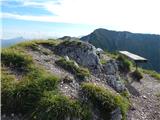
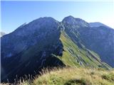
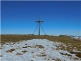
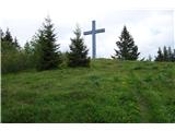
 | Mrzli studenec - Veliki vrh (Košuta)
Veliki Vrh, at 2,088 m, is the westernmost two-thousander in Slovenia's longest ridge, the Košuta. From the summit, which has a registration box ...
2 h 15 min |
 | Rudno polje - Viševnik
Viševnik is a 2050 m high mountain rising northwest of Rudno polje on Pokljuka. From the summit, where there is a stamp, a beautiful view opens o...
2 h |
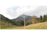
 | Planina Zajavornik - Mrežce
Mrežce is a panoramic peak near Lipanski vrh, which is visible on the other side of the gully between the two peaks. Since the slopes towards Pok...
1 h 55 min |
| Šport hotel - Mrežce
Mrežce is a panoramic peak near Lipanski vrh, which is visible on the other side of the gully between the two peaks. Since the slopes towards Pok...
2 h 40 min |
 | Planina Zajavornik - Mrežce (gentle path)
Mrežce is a panoramic peak near Lipanski vrh, which is visible on the other side of the gully between the two peaks. Since the slopes towards Pok...
2 h |
 | Rudno polje - Mrežce
Mrežce is a panoramic peak near Lipanski vrh, which is visible on the other side of the gully between the two peaks. Since the slopes towards Pok...
2 h 40 min |
 | Pri Rupah - Debela peč
Debela peč is a 2014 m high mountain that rises steeply above the Krma valley on one side and gently descends towards the expansive Pokljuka fore...
2 h 15 min |
| Strmec - Debela peč (via Spodnja Brda)
Debela peč is a 2014 m high mountain that rises steeply above the Krma valley on one side and gently descends towards the expansive Pokljuka fore...
2 h 45 min |
 | Planina Zajavornik - Debela peč
Debela peč is a 2014 m high mountain that rises steeply above the Krma valley on one side and gently descends towards the expansive Pokljuka fore...
2 h 30 min |
| Strmec - Debela peč
Debela peč is a 2014 m high mountain that rises steeply above the Krma valley on one side and gently descends towards the expansive Pokljuka fore...
2 h 30 min |
 | Pod Luknjo - Črna prst
On the northern slope of the summit ridge of Črna prst, black soil is visible the feature after which the mountain is named. Črna prst is renown...
2 h 30 min |
 | Gozd - Tolsti vrh (via Ježa)
Tolsti vrh, located west of Storžič, is at 1715 metres also the highest peak of the Kriška gora range, which rises steeply above central Gorenjsk...
2 h 15 min |
 | Gozd - Tolsti vrh (easier path over Kriška gora)
Tolsti vrh, located west of Storžič, is at 1715 metres also the highest peak of the Kriška gora range, which rises steeply above central Gorenjsk...
2 h 30 min |
 | Grda draga - Veliki Snežnik (via Mali Snežnik)
Veliki Snežnik, at 1796 meters, is the highest peak in the nearby and distant surroundings, offering beautiful views over much of Slovenia and ne...
1 h 55 min |
 | Planina Loka - Velika Raduha
Velika Raduha, at 2062 m, is the highest peak of the Raduha range, which rises steeply east of Robanov Kot. From the summit, with its registratio...
1 h 55 min |
 | Planina Vodol - Velika Raduha
Velika Raduha, at 2062 m, is the highest peak of the Raduha range, which rises steeply east of Robanov Kot. From the summit, with its registratio...
2 h 40 min |
 | Rute (Zavrh) / Bärental - Barentaler Kotschna/Struška (via Bärensattel)
Struška is a smaller mountain range in the Karavanke ridge, located between Stol (specifically Belščica) and Golica. From Veliki vrh (1944 m), th...
2 h 45 min |
 | Planina pod Golico (Betel) - Kahlkogel/Golica
Golica is an unvegetated peak located north of Jesenice. From the summit, where a registration box is placed, there is a fine view of the western...
2 h 20 min |
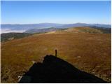
 | Planina Blato - Pršivec
Pršivec is a panoramic mountain above Lake Bohinj. The view is extensive in all directions: Triglav and the surrounding mountains are clearly vis...
2 h 30 min |
 | Planina Zajavornik - Brda (east path)
Brda is a panoramic peak situated between Pokljuka and Krma. The summit has a stamp attached to a metal pole and offers a beautiful view towards ...
2 h 15 min |
 | Pri Rupah - Brda (west path)
Brda is a panoramic peak situated between Pokljuka and Krma. The summit has a stamp attached to a metal pole and offers a beautiful view towards ...
2 h |
 | Pri Rupah - Brda (east path)
Brda is a panoramic peak situated between Pokljuka and Krma. The summit has a stamp attached to a metal pole and offers a beautiful view towards ...
2 h |
 | Jekarica - Bašeljski vrh
Bašeljski vrh is a 1744-meter-high mountain located between Mali Grintovec and Storžič. From the summit, where there is a bench and a registratio...
2 h 10 min |
 | Ravne - Frauenkogel/Dovška Baba (footpath)
Dovška Baba is a 1891-meter-high peak located on the border ridge between Slovenia and Austria. From the summit, which has a registration box and...
1 h 45 min |
| Ravne - Frauenkogel/Dovška Baba (by road)
Dovška Baba is a 1891-meter-high peak located on the border ridge between Slovenia and Austria. From the summit, which has a registration box and...
1 h 50 min |
 | Erjavčev rovt - Frauenkogel/Dovška Baba (via Brvog)
Dovška Baba is a 1891-meter-high peak located on the border ridge between Slovenia and Austria. From the summit, which has a registration box and...
2 h 45 min |
 | Tinčkova koča - Srednji vrh (above Završnica) (via Smokuška planina)
Srednji vrh is a panoramic mountain covered in dwarf pine, located between Stol, Vrtača and Begunjščica. From the summit, which drops steeply to ...
2 h |
| Ljubelj - Srednji vrh (above Završnica) (via source of Završnica)
Srednji vrh is a panoramic mountain covered in dwarf pine, located between Stol, Vrtača and Begunjščica. From the summit, which drops steeply to ...
2 h 40 min |
 | Ljubelj - Srednji vrh (above Završnica) (on a slope of Vrtača)
Srednji vrh is a panoramic mountain covered in dwarf pine, located between Stol, Vrtača and Begunjščica. From the summit, which drops steeply to ...
2 h 40 min |
 | Valvasorjev dom - Prešernova koča na Stolu (Žirovniška way)
The Prešernova koča na Stolu mountain hut is located just a few metres below the summit of the 2198 m high Mali Stol. From the hut or the nearby ...
2 h 45 min |
 | Razpotje Vragovec - Prešernova koča na Stolu (via Zabreška planina)
The Prešernova koča na Stolu mountain hut is located just a few metres below the summit of the 2198 m high Mali Stol. From the hut or the nearby ...
2 h 45 min |
 | Javorje - Rodica (marked way)
The mountain Rodica is located above Bohinj in the Lower Bohinj Mountains. From the summit there is a beautiful view over the Julian Alps and the...
2 h 45 min |
| Rutarski gozd - Rodica
The mountain Rodica is located above Bohinj in the Lower Bohinj Mountains. From the summit there is a beautiful view over the Julian Alps and the...
2 h 30 min |
 | Zgornje Jezersko - Virnikov Grintovec
Virnikov Grintovec is a 1654 m high mountain located north of Jezersko on the border ridge between Slovenia and Austria. From the summit, which h...
2 h 15 min |
| Trögern - Virnikov Grintovec
Virnikov Grintovec is a 1654 m high mountain located north of Jezersko on the border ridge between Slovenia and Austria. From the summit, which h...
2 h 15 min |
 | Kriška planina - Vrh Korena (via Planina Koren)
Vrh Korena is located between Zvoh and Kalški greben near the Krvavec ski resort. The summit offers a beautiful view of the highest peaks in the ...
2 h 15 min |
| Dom na Gospincu - Vrh Korena (via Dolga njiva)
Vrh Korena is located between Zvoh and Kalški greben near the Krvavec ski resort. The summit offers a beautiful view of the highest peaks in the ...
2 h 25 min |
| Planina Jezerca - Vrh Korena (via planina Koren)
Vrh Korena is located between Zvoh and Kalški greben near the Krvavec ski resort. The summit offers a beautiful view of the highest peaks in the ...
2 h 30 min |
 | Kriška planina - Kompotela
Kompotela is a peak near Mokrica and Vrh Korena. The grass- and dwarf pine-covered summit offers a beautiful view towards Grintovec, Skuta, Brana...
2 h 15 min |
| Planina Jezerca - Kompotela
Kompotela is a peak near Mokrica and Vrh Korena. The grass- and dwarf pine-covered summit offers a beautiful view towards Grintovec, Skuta, Brana...
2 h 30 min |
 | Kriška planina - Mokrica (via Kompotela)
Mokrica is a panoramic peak east of Kompotela. The summit, partially covered with dwarf pines, has a summit logbook....
2 h 45 min |
 | Rudno polje - Debeli vrh above Lipanca (via Kačji rob)
Debeli vrh is a 1962 m high mountain located in the ridge that rises steeply above the Krma valley. From the summit, where a stamp is attached to...
2 h 45 min |
 | Planina Zajavornik - Debeli vrh above Lipanca
Debeli vrh is a 1962 m high mountain located in the ridge that rises steeply above the Krma valley. From the summit, where a stamp is attached to...
2 h 30 min |
| Rudno polje - Debeli vrh above Lipanca (via Blejska koča)
Debeli vrh is a 1962 m high mountain located in the ridge that rises steeply above the Krma valley. From the summit, where a stamp is attached to...
2 h 45 min |
 | Planina pod Golico - Rosenkogel/Hruški vrh
Hruški vrh is a 1776-metre-high mountain located between Dovška Baba and the lesser-known Klek. From the summit, where there is a small chapel de...
2 h 30 min |
 | Ravenska Kočna - Goli vrh (slovenian way)
Goli vrh is a 1787 m high mountain situated between the Ravenska Kočna and Belska Kočna valleys. From the bare summit, which has a registration b...
2 h 15 min |
 | Ravenska Kočna - Goli vrh (austrian way)
Goli vrh is a 1787 m high mountain situated between the Ravenska Kočna and Belska Kočna valleys. From the bare summit, which has a registration b...
2 h 30 min |
| Velacher Kotschna/Belska Kočna - Goli vrh
Goli vrh is a 1787 m high mountain situated between the Ravenska Kočna and Belska Kočna valleys. From the bare summit, which has a registration b...
2 h 45 min |
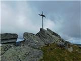
 | Koča pri izviru Soče - Vršič vrh
Vršič is a 1,737-metre-high mountain situated between the Poštarski dom hut and the Vršič pass. From the summit, where there is a registration bo...
2 h 40 min |
 | Planina Podvežak - Veliki vrh (Veža) (via Prag)
Veliki Vrh is a 2,110-metre-high mountain located in the central part of the Dleskovec Plateau. From the summit, where there are two registration...
2 h 20 min |
 | Planina Ravne - Veliki vrh (Veža) (via Zelene trate)
Veliki Vrh is a 2,110-metre-high mountain located in the central part of the Dleskovec Plateau. From the summit, where there are two registration...
2 h 15 min |
| Planina Ravne - Veliki vrh (Veža) (via Dolga trata)
Veliki Vrh is a 2,110-metre-high mountain located in the central part of the Dleskovec Plateau. From the summit, where there are two registration...
2 h 30 min |
| Kraljev dol - Veliki vrh (Veža) (via Planina Vodole)
Veliki Vrh is a 2,110-metre-high mountain located in the central part of the Dleskovec Plateau. From the summit, where there are two registration...
2 h 35 min |
 | Javorje - Šija (via Zadnja Suha)
Šija is located above the Vogel ski resort in the Lower Bohinj Mountains. From the summit, there is a nice view of the neighboring peaks in the s...
2 h 30 min |
 | Koča pri izviru Soče - Sovna glava
Sovna Glava is a 1750-meter-high grassy peak situated between Prisank and the Vršič Pass. From the summit, there is a nice view of the peaks risi...
2 h 40 min |
 | Johannsenruhe - Ovčji vrh (Kozjak) / Geissberg (Kosiak) (southwest path)
Ovčji Vrh or Kozjak, known in German as Geissberg or Kosiak, is a 2024 m high peak located north of the main Karawanks ridge. Rising above Celovš...
2 h 30 min |
| Trate / Johannsenruhe - Ovčji vrh (Kozjak) / Geissberg (Kosiak) (southeast path)
Ovčji Vrh or Kozjak, known in German as Geissberg or Kosiak, is a 2024 m high peak located north of the main Karawanks ridge. Rising above Celovš...
2 h 35 min |
 | Planina Kuk - Vogel (direct way)
Many associate the name Vogel first with the Vogel ski resort near the eponymous peak. From the north, it is recognizable by its pyramidal shape,...
2 h 45 min |
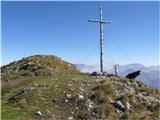
 | Ciganija - Uršlja gora (Plešivec) (winter way)
Uršlja gora, or Plešivec, is a panoramic mountain between Slovenj Gradec and Črna na Koroškem. At or just below the summit stands the Church of S...
2 h 30 min |
 | Ciganija - Uršlja gora (Plešivec)
Uršlja gora, or Plešivec, is a panoramic mountain between Slovenj Gradec and Črna na Koroškem. At or just below the summit stands the Church of S...
2 h 15 min |
 | Andrejev dom na Slemenu - Uršlja gora (Plešivec)
Uršlja gora, or Plešivec, is a panoramic mountain between Slovenj Gradec and Črna na Koroškem. At or just below the summit stands the Church of S...
2 h 45 min |
 | Coot Parking Lot - Monte Guarda/Skutnik
Skutnik is a peak situated north of the Učja River on the border with Italy. From the top, there is a beautiful view of the Kanin mountain group,...
2 h |
 | Salzstiegelhaus - Weißenstein (Packalpe)
Weißenstein is a grassy mountain crisscrossed with wire fences. From its indistinct summit, there is a nice view of the neighboring Ameringkogel ...
2 h 20 min |
 | Salzstiegelhaus - Ameringkogel (Packalpe)
Ameringkogel is a grassy summit with a cross and summit register. At 2,187 meters, it is the highest peak of the Packalpe. In good visibility, th...
2 h 30 min |
 | Žabnice / Camporosso in Valcanale - Svete Višarje / Monte Lussari
Svete Višarje / Monte Lussari is a pilgrimage site for Slavs, Germans, and Romance peoples. Already in the 16th century, the mountain was called ...
2 h 30 min |
 | Jakobe - Petzen (Kordeschkopf) (Peca (Kordeževa glava)) (easy path)
Kordeževa glava, better known as Peca, is the highest peak of the Peca range. It is located on the border with Austria above the Mežiška dolina v...
2 h 15 min |
 | Rudnik v Topli - Mala Peca
Mala Peca is the peak above the Dom na Peci mountain hut on its eastern slopes. From the summit, where a panoramic sign stands, there is a nice v...
2 h 10 min |
 | Trögern - Kärntner Storschitz / Pristovški Storžič
Pristovški Storžič (Kärntner Storschitz) is an exceptionally panoramic peak above Jezersko. From it, there are fine views of the northern walls o...
2 h |
 | Planina Ravne - Velika Zelenica (via Zelene trate)
Velika Zelenica is the highest peak of the Dleskovška plateau, offering panoramic views accordingly. The nearby Ojstrica stands out most prominen...
2 h 15 min |
 | Planina Podvežak - Velika Zelenica (via Prag)
Velika Zelenica is the highest peak of the Dleskovška plateau, offering panoramic views accordingly. The nearby Ojstrica stands out most prominen...
2 h 30 min |
| Planina Ravne - Velika Zelenica (via Dolga trata)
Velika Zelenica is the highest peak of the Dleskovška plateau, offering panoramic views accordingly. The nearby Ojstrica stands out most prominen...
2 h 30 min |
 | Koutschitz Alm/Kočiška planina - Starhand (by road)
Starhand is a panoramic peak in the eastern part of the Carnic Alps near the better-known Ojstrnik. From the top, there are beautiful views of th...
2 h 15 min |
 | Zell-Pharre - Freiberg/Setiče
Setiče/Freiberg (also Z'če or Žetiče) is a panoramic mountain on the Austrian side of the Karawanks. From the summit, which has a cross, there is...
2 h 30 min |
 | Franzbauer - Ferlacher Horn / Grlovec
Grlovec/Ferlacher Horn is a panoramic mountain on which a large cross stands. From the top, there is a beautiful view of the Karawanks, parts of ...
2 h 15 min |
 | Avsa - Monte Mataiur/Matajur
Matajur is a panoramic mountain located on the border between Slovenia and Italy. From the summit there is a beautiful view of Kobariški or Bregi...
2 h 30 min |
 | Avsa - Monte Mataiur/Matajur (old path)
Matajur is a panoramic mountain located on the border between Slovenia and Italy. From the summit there is a beautiful view of Kobariški or Bregi...
2 h 30 min |
 | Windische Hohe - Kobesnock
Kobesnock is a lesser-known peak west of the massive Dobrač range. From its summit, which features a cross, there are fine views of Dobrač, the l...
2 h 45 min |
 | Windische Hohe - Tschekelnock
Čegla gora (German: Tschekelnock) rises steeply above the idyllic mountain village Venetski hrib/Windische Hohe. From its summit, with a cross, t...
2 h 30 min |
 | Ladinger Straße - Ladinger Spitz (Saualpe) (via Offnerhütte)
Velika Svinja, known in German as Ladinger Spitz, is at 2079 m the highest peak of the Svinja / Saualpe mountain range. From the summit, which ha...
2 h 25 min |
| Ladinger Straße - Ladinger Spitz (Saualpe) (via Zechhütte)
Velika Svinja, known in German as Ladinger Spitz, is at 2079 m the highest peak of the Svinja / Saualpe mountain range. From the summit, which ha...
2 h 20 min |
 | Rifugio Tolazzi - Monte Floriz
Monte Floriz is a 2,184 m high grassy peak located south of the Marinelli hut. From the summit there is a very nice view of the Coglians group; i...
2 h 25 min |
 | Bukovnik - Lanež
Lanež is a less distinct peak on the eastern part of Raduha. From the spacious summit a nice view opens on nearby Mala Raduha, Olševa, Peca, Uršl...
2 h 20 min |
 | Planina Kosmačeve Rastke - Lanež (via Durce)
Lanež is a less distinct peak on the eastern part of Raduha. From the spacious summit a nice view opens on nearby Mala Raduha, Olševa, Peca, Uršl...
2 h 25 min |
| Planina Kosmačeve Rastke - Lanež (east path)
Lanež is a less distinct peak on the eastern part of Raduha. From the spacious summit a nice view opens on nearby Mala Raduha, Olševa, Peca, Uršl...
2 h 25 min |
 | Koprein-Petzen - Wackendorfer Spitze
Veška kopa, also known as Veški vrh or by its German name Wackendorfer Spitze, is the northernmost two-thousander in the Peca range. From its ind...
2 h 30 min |
 | Koprein-Petzen - Feistritzer Spitze
Bistriška špica is a 2113 m high peak located on the Austrian side of Peca. From the summit, which features a cross, there is a fine view of the ...
2 h 30 min |
 | Jakobe - Končnikov vrh (Peca) (easy path)
Končnikov vrh (German: Knieps) is a 2109 m high peak situated in the central part of Peca. From the grassy summit, there is a beautiful view of t...
2 h 45 min |
 | Cave del Predil - Šober / Monte Sciober Grande
Šober / Monte Sciober Grande is a 1,845 m high peak located between the Remšendol Valley and Jezerska Valley. From the summit there is a fine vie...
2 h 45 min |
 | Prtovč - Gladki vrh (Ratitovec) (via Razor)
Gladki vrh (Ratitovec), at 1,667 meters, is the most visited peak in the Ratitovec range. From its bare summit, which features a panorama board, ...
1 h 35 min |
| Prtovč - Gladki vrh (Ratitovec) (via Po(v)den)
Gladki vrh (Ratitovec), at 1,667 meters, is the most visited peak in the Ratitovec range. From its bare summit, which features a panorama board, ...
1 h 35 min |
 | Bitenjska planina - Gladki vrh (Ratitovec)
Gladki vrh (Ratitovec), at 1,667 meters, is the most visited peak in the Ratitovec range. From its bare summit, which features a panorama board, ...
2 h 25 min |
 | Prtovč - Altemaver (Ratitovec) (via Razor)
Altemaver (Ratitovec), at 1,678 meters, is the highest peak of Ratitovec. From its grassy summit, there is a beautiful view of the Julian Alps, J...
1 h 50 min |
| Prtovč - Altemaver (Ratitovec) (via Po(v)den)
Altemaver (Ratitovec), at 1,678 meters, is the highest peak of Ratitovec. From its grassy summit, there is a beautiful view of the Julian Alps, J...
1 h 50 min |
 | Zgornje Danje - Altemaver (Ratitovec)
Altemaver (Ratitovec), at 1,678 meters, is the highest peak of Ratitovec. From its grassy summit, there is a beautiful view of the Julian Alps, J...
1 h 45 min |
| Bitenjska planina - Altemaver (Ratitovec)
Altemaver (Ratitovec), at 1,678 meters, is the highest peak of Ratitovec. From its grassy summit, there is a beautiful view of the Julian Alps, J...
2 h 30 min |
| Rotek - Altemaver (Ratitovec)
Altemaver (Ratitovec), at 1,678 meters, is the highest peak of Ratitovec. From its grassy summit, there is a beautiful view of the Julian Alps, J...
2 h 30 min |
 | Planina Podvežak - Mala Ojstrica
Mala Ojstrica is an indistinct peak located between Ojstrica, Molička Planina mountain pasture, and Korošica. From the summit, which features a l...
2 h 30 min |
 | Baumgartnerhof - Maloško poldne / Mallestiger Mittagskogel
Maloško poldne, or Mallestiger Mittagskogel in German, is a 1,823-meter-high peak on the border between Slovenia and Austria, precisely between T...
2 h 45 min |
 | Rifugio Selvapiana I.Lunelli - Croda Sora I Colesei / Arzalpenkopf (via Forcella Popera)
Croda Sora I Colesei (German: Arzalpenkopf) is a 2,321-meter-high mountain on the eastern edge of the Sexten Dolomites (Dolomiti di Sesto). The s...
2 h 30 min |
| Rifugio Selvapiana I.Lunelli - Croda Sora I Colesei / Arzalpenkopf (via Belvedere)
Croda Sora I Colesei (German: Arzalpenkopf) is a 2,321-meter-high mountain on the eastern edge of the Sexten Dolomites (Dolomiti di Sesto). The s...
2 h 30 min |
 | Rotek - Kremant (Ratitovec)
Kremant is a 1,654 m high peak located on the western part of Ratitovec. From the summit, where a stamp is attached to a metal pole, a nice view ...
2 h 30 min |
 | Forni di Sopra - Clap Varmost
Clap Varmost is a panoramic peak situated north to northwest of Forni di Sopra. From the top, where a cross with a register box stands, a nice vi...
2 h |
 | Tolminske Ravne - Tolminski Migovec
Tolminski Migovec is a 1881 m high mountain. Its western slope above the Tolminka valley is the steepest and most scenic. The southern slope is i...
2 h 45 min |
 | Glashütten (Gasthof Almwirt) - Handalm
Handalm is a 1853-meter-high peak located north to northeast of the alpine pass Weinebene. From the grassy summit, which features small granite r...
2 h 30 min |
 | Žabnice / Camporosso in Valcanale - Florjanka / Monte Florianca
Florjanka is a 1,653-meter-high mountain on the Italian side of the Julian Alps. At or just below the summit is a reservoir for snowmaking on the...
2 h 30 min |
 | Rute (Zavrh) / Bärental - Mačenski vrh / Matschacher Gupf (via 668)
Mačenski vrh / Matschacher Gupf is a panoramic peak above Rož / Rosental. The peak has a summit register box with a logbook....
2 h 15 min |
| Rute (Zavrh) / Bärental - Mačenski vrh / Matschacher Gupf (over saddle Mrzla raven / Gipssattel)
Mačenski vrh / Matschacher Gupf is a panoramic peak above Rož / Rosental. The peak has a summit register box with a logbook....
2 h 15 min |
 | Planina Zajzera - Krniška glavica / Jof di Sompdogna
Krniška glavica (Jof di Sompdogna) is a 1,889-meter-high peak in the Western Julian Alps, north of Montaž. A cross stands on the panoramic summit...
2 h 30 min |
 | Glashütten - Steinmandl (Golica / Koralpe)
Steinmandl is a panoramic peak in the Golica/Koralpe range, where numerous stone cairns have been built....
2 h 25 min |
 | Mönichkirchen - Niederwechsel (via Steinerne Stiege)
Niederwechsel is a panoramic peak in the Wechsel massif. From the summit, fine views extend far in all directions, since there are no higher peak...
2 h 25 min |
 | Rettenegg - Geiereck (past Roseggerhaus)
Geiereck is a panoramic peak located northeast of the Roseggerhaus hut and southeast of the Geiereckalm alpine pasture....
2 h 25 min |
 | Rettenegg - Peter-Bergner-Warte (Pretul) (past Roseggerhaus)
The Peter-Bergner-Warte viewpoint is located on the 1,656-meter-high Pretul summit above the settlement of Rettenegg....
2 h 15 min |
 | Rettenegg - Amundsenhöhe (past Roseggerhaus)
Amundsenhöhe is a 1,666-meter-high panoramic peak in the Fischbacher Alpen mountain group. From the summit there is a nice view of the hill count...
2 h 25 min |
 | Hirschegg - Seinerkreuz
Seinerkreuz is a panoramic peak located above the Saureishütte hut and the settlement of Hirschegg. From the summit, a beautiful view opens up of...
2 h 35 min |
 | Sankt Ilgen (Der Bodenbauer) - Buchbergkogel
Buchbergkogel is a 1,700-meter panoramic mountain above the Häuslalmhütte hut and the Joseralm and Heinzleralm pastures. A cross stands on the su...
2 h 30 min |
 | Alpengasthof Scheikl - Hohe Veitsch
Hohe Veitsch is the highest peak of the Veitsch mountain range, located in the eastern part of the Northern Limestone Alps. From the summit, a be...
2 h 20 min |
 | Niklasdorfgraben (parking lot Mugel) - Rosseck (via Mugel)
Roßeck (or Rosseck) is a 1664 m high peak on the Gleinalpe, not far from the slightly lower Mugel (1640 m).Both peaks are linked by a saddle at 1...
2 h 30 min |
 | Preiner Gscheid - Heukuppe (Rax) (Schlangenweg)
Heukuppe is a 2007-meter-high peak in the Northern Limestone Alps and the highest peak of the Rax mountain group. A large monument stands on the ...
2 h 35 min |
| Preiner Gscheid - Heukuppe (Rax) (past Helenenquelle)
Heukuppe is a 2007-meter-high peak in the Northern Limestone Alps and the highest peak of the Rax mountain group. A large monument stands on the ...
2 h 35 min |
 | Preiner Gscheid - Preiner Wand (Rax) (Göbl-Kühn-Steig)
Preiner Wand is a panoramic peak in the Rax mountain group, where a large cross stands....
2 h 40 min |
 | Ladinger Straße - Sandkogel (via Offnerhütte)
Sandkogel is an indistinct panoramic peak rising to 2011 meters in the Svinja range....
2 h 20 min |
| Ladinger Straße - Sandkogel (via Zechhütte)
Sandkogel is an indistinct panoramic peak rising to 2011 meters in the Svinja range....
2 h 15 min |