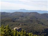
 | Tomčeva koča na Poljški planini - Begunjščica
Begunjščica is a mountain range in the Karawanks east of Stol. Its highest peak is Veliki Vrh, which at over 2,000 m offers a fine view across ce...
2 h 50 min |
 | Valvasorjev dom pod Stolom - Hochstuhl/Stol (Zabreška way)
Stol is, at 2,236 m, the highest peak in the Karawanks. From the summit, which has a registration box and stamp, a beautiful view opens onto the ...
3 h 20 min |
 | Valvasorjev dom pod Stolom - Hochstuhl/Stol (Žirovniška way)
Stol is, at 2,236 m, the highest peak in the Karawanks. From the summit, which has a registration box and stamp, a beautiful view opens onto the ...
3 h |
 | Razpotje Vragovec - Hochstuhl/Stol (via Zabreška planina)
Stol is, at 2,236 m, the highest peak in the Karawanks. From the summit, which has a registration box and stamp, a beautiful view opens onto the ...
3 h |
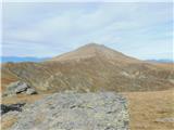
 | Globoka dolina - Veliki vrh (Košuta)
Veliki Vrh, at 2,088 m, is the westernmost two-thousander in Slovenia's longest ridge, the Košuta. From the summit, which has a registration box ...
3 h |
 | Šport hotel - Mrežce
Mrežce is a panoramic peak near Lipanski vrh, which is visible on the other side of the gully between the two peaks. Since the slopes towards Pok...
2 h 40 min |
 | Rudno polje - Lipanski vrh
The panoramic Lipanski vrh is located above the Blejska koča on the Lipanca mountain pasture. From the summit, which drops steeply towards the Kr...
2 h 55 min |
 | Strmec - Debela peč (via Spodnja Brda)
Debela peč is a 2014 m high mountain that rises steeply above the Krma valley on one side and gently descends towards the expansive Pokljuka fore...
2 h 45 min |
 | Planina Zajavornik - Debela peč
Debela peč is a 2014 m high mountain that rises steeply above the Krma valley on one side and gently descends towards the expansive Pokljuka fore...
2 h 30 min |
| Šport hotel - Debela peč
Debela peč is a 2014 m high mountain that rises steeply above the Krma valley on one side and gently descends towards the expansive Pokljuka fore...
3 h 30 min |
 | Rudno polje - Debela peč
Debela peč is a 2014 m high mountain that rises steeply above the Krma valley on one side and gently descends towards the expansive Pokljuka fore...
3 h 15 min |
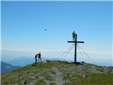
 | Dom pod Storžičem - Storžič (through southwest groove)
Storžič is a 2132 m high mountain located in the western part of the Kamnik-Savinja Alps. From the summit, where there is a cross, a beautiful vi...
3 h 50 min |
 | Vrh Bače - Črna prst
On the northern slope of the summit ridge of Črna prst, black soil is visible the feature after which the mountain is named. Črna prst is renown...
3 h 10 min |
 | Pod Luknjo - Črna prst
On the northern slope of the summit ridge of Črna prst, black soil is visible the feature after which the mountain is named. Črna prst is renown...
2 h 30 min |
 | Mašun - Snežnik
Snežnik, or Veliki Snežnik, at 1796 metres is the highest peak in the near and far surroundings, offering a beautiful view over a large part of S...
4 h |
 | Bukovnik - Velika Raduha (via Durce)
Velika Raduha, at 2062 m, is the highest peak of the Raduha range, which rises steeply east of Robanov Kot. From the summit, with its registratio...
2 h 50 min |
 | Radušnik - Velika Raduha
Velika Raduha, at 2062 m, is the highest peak of the Raduha range, which rises steeply east of Robanov Kot. From the summit, with its registratio...
3 h 10 min |
| Planina Kosmačeve Rastke - Velika Raduha
Velika Raduha, at 2062 m, is the highest peak of the Raduha range, which rises steeply east of Robanov Kot. From the summit, with its registratio...
2 h 55 min |
 | Planina Vodol - Velika Raduha
Velika Raduha, at 2062 m, is the highest peak of the Raduha range, which rises steeply east of Robanov Kot. From the summit, with its registratio...
2 h 40 min |
 | Rute (Zavrh) / Bärental - Barentaler Kotschna/Struška (via Bärensattel)
Struška is a smaller mountain range located between Stol (or Belščica) and Golica. From its highest peak, Veliki vrh, there is a beautiful view o...
2 h 45 min |
 | Planina pod Golico - Kahlkogel/Golica (via Suha saddle)
Golica is a treeless peak located north of Jesenice. The summit features a registration box and offers a beautiful view of the western Karawanks ...
3 h |
 | Dom Pristava in Javorniški Rovt - Kahlkogel/Golica (via mountain hut)
Golica is a treeless peak located north of Jesenice. The summit features a registration box and offers a beautiful view of the western Karawanks ...
2 h 45 min |
 | Planina Blato - Pršivec
Pršivec is a panoramic mountain above Lake Bohinj. The view is extensive in all directions: Triglav and the surrounding mountains are clearly vis...
2 h 30 min |
 | Šport hotel - Brda (east path)
Brda is a panoramic peak situated between Pokljuka and Krma. The summit has a stamp attached to a metal pole and offers a beautiful view towards ...
3 h 15 min |
 | Rudno polje - Brda (east path)
Brda is a panoramic peak situated between Pokljuka and Krma. The summit has a stamp attached to a metal pole and offers a beautiful view towards ...
3 h 10 min |
 | Rudno polje - Brda (west path)
Brda is a panoramic peak situated between Pokljuka and Krma. The summit has a stamp attached to a metal pole and offers a beautiful view towards ...
2 h 55 min |
 | Erjavčev rovt - Frauenkogel/Dovška Baba (via Brvog)
Dovška Baba is a 1891-meter-high peak located on the border ridge between Slovenia and Austria. From the summit, which has a registration box and...
2 h 45 min |
 | Ljubelj - Srednji vrh (above Završnica) (via source of Završnica)
Srednji vrh is a panoramic mountain covered in dwarf pine, located between Stol, Vrtača and Begunjščica. From the summit, which drops steeply to ...
2 h 40 min |
 | Ljubelj - Srednji vrh (above Završnica) (on the slope of Vrtača)
Srednji vrh is a panoramic mountain covered in dwarf pine, located between Stol, Vrtača and Begunjščica. From the summit, which drops steeply to ...
3 h |
 | Ljubelj - Srednji vrh (above Završnica) (on a slope of Vrtača)
Srednji vrh is a panoramic mountain covered in dwarf pine, located between Stol, Vrtača and Begunjščica. From the summit, which drops steeply to ...
2 h 40 min |
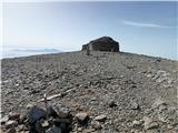
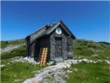
 | Valvasorjev dom - Prešernova koča na Stolu (Zabreška way)
The Prešernova koča na Stolu mountain hut is located just a few metres below the summit of the 2198 m high Mali Stol. From the hut or the nearby ...
3 h 5 min |
 | Valvasorjev dom - Prešernova koča na Stolu (Žirovniška way)
The Prešernova koča na Stolu mountain hut is located just a few metres below the summit of the 2198 m high Mali Stol. From the hut or the nearby ...
2 h 45 min |
 | Razpotje Vragovec - Prešernova koča na Stolu (via Zabreška planina)
The Prešernova koča na Stolu mountain hut is located just a few metres below the summit of the 2198 m high Mali Stol. From the hut or the nearby ...
2 h 45 min |
 | Javorje - Rodica (marked way)
The mountain Rodica is located above Bohinj in the Lower Bohinj Mountains. From the summit there is a beautiful view over the Julian Alps and the...
2 h 45 min |
 | Ski hotel Vogel - Rodica
The mountain Rodica is located above Bohinj in the Lower Bohinj Mountains. From the summit there is a beautiful view over the Julian Alps and the...
3 h |
| Rutarski gozd - Rodica
The mountain Rodica is located above Bohinj in the Lower Bohinj Mountains. From the summit there is a beautiful view over the Julian Alps and the...
2 h 30 min |
 | Markova raven - Vrh Korena (marked way)
Vrh Korena is located between Zvoh and Kalški greben near the Krvavec ski resort. The summit offers a beautiful view of the highest peaks in the ...
3 h 15 min |
| Planina Jezerca - Vrh Korena (via planina Koren)
Vrh Korena is located between Zvoh and Kalški greben near the Krvavec ski resort. The summit offers a beautiful view of the highest peaks in the ...
2 h 30 min |
 | Kriška planina - Kalški greben (via planina Koren)
Kalški greben is a 2224 m high peak and the highest point of the ridge bearing the same name. From the summit, where there is a summit register a...
3 h 45 min |
| Dom na Gospincu - Kalški greben (via Dolga Njiva)
Kalški greben is a 2224 m high peak and the highest point of the ridge bearing the same name. From the summit, where there is a summit register a...
3 h 20 min |
| Planina Jezerca - Kalški greben (via planina Koren)
Kalški greben is a 2224 m high peak and the highest point of the ridge bearing the same name. From the summit, where there is a summit register a...
4 h |
 | Markova raven - Kompotela (marked way)
Kompotela is a peak near Mokrica and Vrh Korena. The grass- and dwarf pine-covered summit offers a beautiful view towards Grintovec, Skuta, Brana...
3 h |
| Planina Jezerca - Kompotela
Kompotela is a peak near Mokrica and Vrh Korena. The grass- and dwarf pine-covered summit offers a beautiful view towards Grintovec, Skuta, Brana...
2 h 30 min |
 | Kriška planina - Mokrica (via Kompotela)
Mokrica is a panoramic peak east of Kompotela. The summit, partially covered with dwarf pines, has a summit logbook....
2 h 45 min |
| Markova raven - Mokrica (marked way)
Mokrica is a panoramic peak east of Kompotela. The summit, partially covered with dwarf pines, has a summit logbook....
3 h 30 min |
| Planina Jezerca - Mokrica (via Kompotela)
Mokrica is a panoramic peak east of Kompotela. The summit, partially covered with dwarf pines, has a summit logbook....
3 h |
 | Rudno polje - Debeli vrh above Lipanca (via Kačji rob)
Debeli vrh is a 1962 m high mountain located in the ridge that rises steeply above the Krma valley. From the summit, where a stamp is attached to...
2 h 45 min |
 | Planina Zajavornik - Debeli vrh above Lipanca
Debeli vrh is a 1962 m high mountain located in the ridge that rises steeply above the Krma valley. From the summit, where a stamp is attached to...
2 h 30 min |
| Šport hotel - Debeli vrh above Lipanca
Debeli vrh is a 1962 m high mountain located in the ridge that rises steeply above the Krma valley. From the summit, where a stamp is attached to...
3 h 15 min |
| Rudno polje - Debeli vrh above Lipanca (via Blejska koča)
Debeli vrh is a 1962 m high mountain located in the ridge that rises steeply above the Krma valley. From the summit, where a stamp is attached to...
2 h 45 min |
 | Jekarica - Mali Grintovec
Mali Grintovec is a panoramic mountain located east of Storžič. From the summit, which has a summit register box, stamp, and a pleasant bench, th...
2 h 50 min |
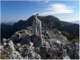
 | Planina pod Golico - Rosenkogel/Hruški vrh
Hruški vrh is a 1776-metre-high mountain located between Dovška Baba and the lesser-known Klek. From the summit, where there is a small chapel de...
2 h 30 min |
 | Ravenska Kočna - Goli vrh (austrian way)
Goli vrh is a 1787 m high mountain situated between the Ravenska Kočna and Belska Kočna valleys. From the bare summit, which has a registration b...
2 h 30 min |
| Velacher Kotschna/Belska Kočna - Goli vrh
Goli vrh is a 1787 m high mountain situated between the Ravenska Kočna and Belska Kočna valleys. From the bare summit, which has a registration b...
2 h 45 min |
 | Baumgartnerhof - Kresišče
Kresišče is an 1839 m high peak in the main ridge of the Karawanks, specifically between Kepa and Trupejevo poldne. From the summit, where a wood...
3 h |
 | Planina Kuhinja - Batognica (via jezero v Lužnici)
Batognica is a 2164 m high mountain that was the site of the so-called mine warfare during World War I. Remnants of the fighting between Italian ...
4 h |
 | Planina Ravne - Veliki vrh (Veža) (via Dolga trata)
Veliki Vrh is a 2,110-metre-high mountain located in the central part of the Dleskovec Plateau. From the summit, where there are two registration...
2 h 30 min |
 | Kraljev dol - Veliki vrh (Veža) (via Planina Vodole)
Veliki Vrh is a 2,110-metre-high mountain located in the central part of the Dleskovec Plateau. From the summit, where there are two registration...
2 h 35 min |
 | Javorje - Šija (via Zadnja Suha)
Šija is located above the Vogel ski resort in the Lower Bohinj Mountains. From the summit, there is a nice view of the neighboring peaks in the s...
2 h 30 min |
 | Baumgartnerhof - Mallestiger Mittagskogel
Ostra peč, known in German as Mallestiger Mittagskogel, is an 1801 m high mountain located on the northern side of the main Karawanks ridge. From...
3 h 15 min |
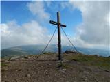
 | Valvasorjev dom pod Stolom - Potoški Stol
Potoški Stol is located between Stol and Vajnež on the border with Austria. A cross stands just a few metres below the grassy summit. The finest ...
3 h 5 min |
 | Mašun - Mali Snežnik
Mali Snežnik is a peak on the western ridge of Snežnik. Covered with dwarf pines, the summit offers beautiful views of the neighboring Veliki Sne...
3 h 35 min |
 | Kurnikovo sedlo - Hochobir (Ojstrc) (footpath)
Ojstrc (Hochobir) is the highest peak of the smaller Obir range. It is located west of Železna Kapla (Eisenkappel) on the Austrian side of the Ka...
3 h 5 min |
| Zell-Schaida - Hochobir (Ojstrc)
Ojstrc (Hochobir) is the highest peak of the smaller Obir range. It is located west of Železna Kapla (Eisenkappel) on the Austrian side of the Ka...
3 h |
 | Johannsenruhe - Ovčji vrh (Kozjak) / Geissberg (Kosiak) (southwest path)
Ovčji Vrh or Kozjak, known in German as Geissberg or Kosiak, is a 2024 m high peak located north of the main Karawanks ridge. Rising above Celovš...
2 h 30 min |
| Trate / Johannsenruhe - Ovčji vrh (Kozjak) / Geissberg (Kosiak) (southeast path)
Ovčji Vrh or Kozjak, known in German as Geissberg or Kosiak, is a 2024 m high peak located north of the main Karawanks ridge. Rising above Celovš...
2 h 35 min |
 | Planina Kuk - Vogel (direct way)
Many associate the name Vogel first with the Vogel ski resort near the eponymous peak. From the north, it is recognizable by its pyramidal shape,...
2 h 45 min |
| Planina Kuk - Vogel (via Globoko)
Many associate the name Vogel first with the Vogel ski resort near the eponymous peak. From the north, it is recognizable by its pyramidal shape,...
3 h 30 min |
 | Ciganija - Uršlja gora (Plešivec) (winter way)
Uršlja gora, or Plešivec, is a panoramic mountain between Slovenj Gradec and Črna na Koroškem. At or just below the summit stands the Church of S...
2 h 30 min |
 | Andrejev dom na Slemenu - Uršlja gora (Plešivec)
Uršlja gora, or Plešivec, is a panoramic mountain between Slovenj Gradec and Črna na Koroškem. At or just below the summit stands the Church of S...
2 h 45 min |
 | Koutschitz Alm/Kočiška planina - Poludnig/Poludnik
Poludnik/Poludnig is located on the eastern part of the Carnic Alps. Because there is no higher peak nearby, there is a very nice view from Polud...
3 h |
 | Waldheimhütte - Zirbitzkogel (via Wildsee)
Zirbitzkogel, at 2,396 m, is the highest peak of the Labotniške Alpe / Seetaler Alpen. From the summit, where a cross and a panorama board stand,...
3 h 32 min |
 | Tonnerhütte - Zirbitzkogel
Zirbitzkogel, at 2,396 m, is the highest peak of the Labotniške Alpe / Seetaler Alpen. From the summit, where a cross and a panorama board stand,...
2 h 32 min |
| Waldheimhütte - Zirbitzkogel (via Rothaidenhütte)
Zirbitzkogel, at 2,396 m, is the highest peak of the Labotniške Alpe / Seetaler Alpen. From the summit, where a cross and a panorama board stand,...
3 h 7 min |
| Waldheimhütte - Zirbitzkogel (via Lavantsee)
Zirbitzkogel, at 2,396 m, is the highest peak of the Labotniške Alpe / Seetaler Alpen. From the summit, where a cross and a panorama board stand,...
2 h 47 min |
 | Waldheimhütte - Fuchskogel (via Wildsee)
Fuchskogel is a peak south of Zirbitzkogel in the Seetaler Alpen mountain group. The summit is broad and mostly covered in grass. More precisely,...
2 h 45 min |
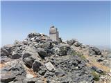
 | Waldheimhütte - Scharfes Eck (Direct way)
Scharfes Eck is a peak on which stands an Austrian meteorological radar station. From the summit, there is a beautiful view of the neighbouring p...
2 h 45 min |
| Tonnerhütte - Scharfes Eck
Scharfes Eck is a peak on which stands an Austrian meteorological radar station. From the summit, there is a beautiful view of the neighbouring p...
3 h |
 | Salzstiegelhaus - Ameringkogel (Packalpe)
Ameringkogel is a grassy summit with a cross and summit register. At 2,187 meters, it is the highest peak of the Packalpe. In good visibility, th...
2 h 30 min |
 | Salzstiegelhaus - Großenberg (Packalpe) (via Ameringkogel)
Großenberg, also known as Größing, is the northernmost two-thousander in the Packalpe mountain group. From its expansive grassy summit, where a t...
3 h |
| Salzstiegelhaus - Großenberg (Packalpe)
Großenberg, also known as Größing, is the northernmost two-thousander in the Packalpe mountain group. From its expansive grassy summit, where a t...
2 h 55 min |
 | Nassfeld - Monte Cavallo / Rosskofel (via Sella di Aip / Rudnig sattel)
Konjski Špik / Monte Cavallo di Pontebba / Rosskofel is a 2,240-meter-high and highly panoramic mountain in the main ridge of the Carnic Alps in ...
4 h |
 | Koprein-Petzen - Petzen (Kordeschkopf) (Peca (Kordeževa glava))
Kordeževa glava, better known as Peca, is the highest peak of the Peca range. It is located on the border with Austria above the Mežiška dolina v...
4 h |
 | Rudnik v Topli - Petzen (Kordeschkopf) (Peca (Kordeževa glava)) (via hut, easy)
Kordeževa glava, better known as Peca, is the highest peak of the Peca range. It is located on the border with Austria above the Mežiška dolina v...
3 h 30 min |
| Pod Peco / Koprein-Petzen - Petzen (Kordeschkopf) (Peca (Kordeževa glava)) (slovenska pot)
Kordeževa glava, better known as Peca, is the highest peak of the Peca range. It is located on the border with Austria above the Mežiška dolina v...
3 h 50 min |
| Koprivna (Kumer) - Petzen (Kordeschkopf) (Peca (Kordeževa glava))
Kordeževa glava, better known as Peca, is the highest peak of the Peca range. It is located on the border with Austria above the Mežiška dolina v...
3 h 25 min |
 | Koča na Pikovem - Petzen (Kordeschkopf) (Peca (Kordeževa glava)) (via saddle Vrh šteng and on easy path)
Kordeževa glava, better known as Peca, is the highest peak of the Peca range. It is located on the border with Austria above the Mežiška dolina v...
4 h 15 min |
 | Spodnje Sleme - Govca (Olševa)
Govca is the highest peak of the Olševa range, rising above Koprivna, Solčava, and Remšenik (Remšenik/Remschenig is a valley on the Austrian side...
3 h |
 | Pod Peco / Koprein-Petzen - Govca (Olševa) (via Kumer)
Govca is the highest peak of the Olševa range, rising above Koprivna, Solčava, and Remšenik (Remšenik/Remschenig is a valley on the Austrian side...
4 h 30 min |
| Mountain hut on farm Kumer - Govca (Olševa)
Govca is the highest peak of the Olševa range, rising above Koprivna, Solčava, and Remšenik (Remšenik/Remschenig is a valley on the Austrian side...
3 h 45 min |
 | Planina Podvežak - Velika Zelenica (via Prag)
Velika Zelenica is the highest peak of the Dleskovška plateau, offering panoramic views accordingly. The nearby Ojstrica stands out most prominen...
2 h 30 min |
 | Planina Ravne - Velika Zelenica (via Dolga trata)
Velika Zelenica is the highest peak of the Dleskovška plateau, offering panoramic views accordingly. The nearby Ojstrica stands out most prominen...
2 h 30 min |
 | Zell-Pharre - Freiberg/Setiče
Setiče/Freiberg (also Z'če or Žetiče) is a panoramic mountain on the Austrian side of the Karawanks. From the summit, which has a cross, there is...
2 h 30 min |
 | Windische Hohe - Kobesnock
Kobesnock is a lesser-known peak west of the massive Dobrač range. From its summit, which features a cross, there are fine views of Dobrač, the l...
2 h 45 min |
 | Windische Hohe - Tschekelnock
Čegla gora (German: Tschekelnock) rises steeply above the idyllic mountain village Venetski hrib/Windische Hohe. From its summit, with a cross, t...
2 h 30 min |
 | Waldrast - Großer Speikkogel (Koralpe) (via Großhöllerhütte)
Großer Speikkogel is, at 2,140 meters, the highest peak of Golica/Koralpe, a range east of Volšperk/Wolfsberg. From the summit, where a cross and...
3 h 45 min |
 | parking below Weinebene - Großer Speikkogel (Koralpe) (panoramic path)
Großer Speikkogel is, at 2,140 meters, the highest peak of Golica/Koralpe, a range east of Volšperk/Wolfsberg. From the summit, where a cross and...
3 h |
| parking below Weinebene - Großer Speikkogel (Koralpe) (via cross Schäferkreuz)
Großer Speikkogel is, at 2,140 meters, the highest peak of Golica/Koralpe, a range east of Volšperk/Wolfsberg. From the summit, where a cross and...
3 h 15 min |
| parking below Weinebene - Großer Speikkogel (Koralpe) (via Grünangerhütte)
Großer Speikkogel is, at 2,140 meters, the highest peak of Golica/Koralpe, a range east of Volšperk/Wolfsberg. From the summit, where a cross and...
3 h 10 min |
 | Waldrast - Großer Speikkogel (Koralpe) (by the edge of the Großes Kar plateau)
Großer Speikkogel is, at 2,140 meters, the highest peak of Golica/Koralpe, a range east of Volšperk/Wolfsberg. From the summit, where a cross and...
2 h 45 min |
| Oberfresen (Brendlwald) - Großer Speikkogel (Koralpe) (lower path)
Großer Speikkogel is, at 2,140 meters, the highest peak of Golica/Koralpe, a range east of Volšperk/Wolfsberg. From the summit, where a cross and...
4 h 15 min |
| Oberfresen (Brendlwald) - Großer Speikkogel (Koralpe) (upper path)
Großer Speikkogel is, at 2,140 meters, the highest peak of Golica/Koralpe, a range east of Volšperk/Wolfsberg. From the summit, where a cross and...
3 h 45 min |
| Glashütten - Großer Speikkogel (Koralpe)
Großer Speikkogel is, at 2,140 meters, the highest peak of Golica/Koralpe, a range east of Volšperk/Wolfsberg. From the summit, where a cross and...
3 h 55 min |
 | Ladinger Straße - Ladinger Spitz (Saualpe) (via Ladinger Hütte)
Velika Svinja, known in German as Ladinger Spitz, is at 2079 m the highest peak of the Svinja / Saualpe mountain range. From the summit, which ha...
3 h |
 | Ladinger Straße - Ladinger Spitz (Saualpe) (via Wolfsberger Hütte)
Velika Svinja, known in German as Ladinger Spitz, is at 2079 m the highest peak of the Svinja / Saualpe mountain range. From the summit, which ha...
2 h 50 min |
 | Klippitztörl - Ladinger Spitz (Saualpe) (via Geierkogel and Gertrusk)
Velika Svinja, known in German as Ladinger Spitz, is at 2079 m the highest peak of the Svinja / Saualpe mountain range. From the summit, which ha...
4 h 10 min |
 | Goldberg - Jaukenstöckl
Jaukenstöckl is a 2209 m high peak on the western side of the panoramic Jauken ridge. From the summit, where a statue of the Virgin Mary stands, ...
3 h 45 min |
 | Goldberg - Jaukenhöhe
Jaukenhöhe is a little-visited peak in the Jauken ridge. It lies west of Torkofel, the highest point in the ridge at 2276 m. The grassy, steep su...
3 h 45 min |
 | Etrachsee - Bauleiteck
Bauleiteck is a panoramic peak located on the eastern part of the Schladminger Tauern mountain group. From the summit, where a cross stands, ther...
3 h 15 min |
 | Rudno polje - Okroglež
Okroglež is a peak covered with dwarf pines, located between Debela peč and Brda. From the summit, which has a stamp (no logbook), a nice view op...
2 h 55 min |
 | Koprein-Petzen - Wackendorfer Spitze
Veška kopa, also known as Veški vrh or by its German name Wackendorfer Spitze, is the northernmost two-thousander in the Peca range. From its ind...
2 h 30 min |
| Koprivna (Kumer) - Wackendorfer Spitze
Veška kopa, also known as Veški vrh or by its German name Wackendorfer Spitze, is the northernmost two-thousander in the Peca range. From its ind...
2 h 55 min |
 | Koprein-Petzen - Feistritzer Spitze
Bistriška špica is a 2113 m high peak located on the Austrian side of Peca. From the summit, which features a cross, there is a fine view of the ...
2 h 30 min |
| Jakobe - Feistritzer Spitze (easy path)
Bistriška špica is a 2113 m high peak located on the Austrian side of Peca. From the summit, which features a cross, there is a fine view of the ...
3 h 45 min |
| Koprivna (Kumer) - Feistritzer Spitze (Austrian path)
Bistriška špica is a 2113 m high peak located on the Austrian side of Peca. From the summit, which features a cross, there is a fine view of the ...
2 h 55 min |
 | Koprivna (Kumer) - Feistritzer Spitze (slovenska pot)
Bistriška špica is a 2113 m high peak located on the Austrian side of Peca. From the summit, which features a cross, there is a fine view of the ...
3 h 40 min |
 | Koprein-Petzen - Končnikov vrh (Peca)
Končnikov vrh (German: Knieps) is a 2109 m high peak situated in the central part of Peca. From the grassy summit, there is a beautiful view of t...
3 h 15 min |
 | Pod Peco/Koprein-Petzen - Končnikov vrh (Peca) (slovenska pot)
Končnikov vrh (German: Knieps) is a 2109 m high peak situated in the central part of Peca. From the grassy summit, there is a beautiful view of t...
3 h 15 min |
| Koprivna (Kumer) - Končnikov vrh (Peca) (slovenska pot)
Končnikov vrh (German: Knieps) is a 2109 m high peak situated in the central part of Peca. From the grassy summit, there is a beautiful view of t...
2 h 55 min |
| Jakobe - Končnikov vrh (Peca) (easy path)
Končnikov vrh (German: Knieps) is a 2109 m high peak situated in the central part of Peca. From the grassy summit, there is a beautiful view of t...
2 h 45 min |
 | Forestry cottage Rovtarica - Gladki vrh (Ratitovec)
Gladki vrh (Ratitovec), at 1,667 meters, is the most visited peak in the Ratitovec range. From its bare summit, which features a panorama board, ...
3 h 35 min |
 | Forestry cottage Rovtarica - Altemaver (Ratitovec)
Altemaver (Ratitovec), at 1,678 meters, is the highest peak of Ratitovec. From its grassy summit, there is a beautiful view of the Julian Alps, J...
3 h 40 min |
 | Rotek - Altemaver (Ratitovec)
Altemaver (Ratitovec), at 1,678 meters, is the highest peak of Ratitovec. From its grassy summit, there is a beautiful view of the Julian Alps, J...
2 h 30 min |
 | Plockenpass - Creta di Collinetta / Cellon
Creta di Collinetta / Cellon is a 2,238-meter-high mountain located west of the Plöcken Pass. From the summit, which features a cross, there is a...
3 h |
 | Planina Podvežak - Mala Ojstrica
Mala Ojstrica is an indistinct peak located between Ojstrica, Molička Planina mountain pasture, and Korošica. From the summit, which features a l...
2 h 30 min |
 | Planina Ravne - Mala Ojstrica (via Dolga trata)
Mala Ojstrica is an indistinct peak located between Ojstrica, Molička Planina mountain pasture, and Korošica. From the summit, which features a l...
3 h 45 min |
 | Baumgartnerhof - Maloško poldne / Mallestiger Mittagskogel
Maloško poldne, or Mallestiger Mittagskogel in German, is a 1,823-meter-high peak on the border between Slovenia and Austria, precisely between T...
2 h 45 min |
 | Rifugio Selvapiana I.Lunelli - Croda Sora I Colesei / Arzalpenkopf (via Forcella Popera)
Croda Sora I Colesei (German: Arzalpenkopf) is a 2,321-meter-high mountain on the eastern edge of the Sexten Dolomites (Dolomiti di Sesto). The s...
2 h 30 min |
| Rifugio Selvapiana I.Lunelli - Croda Sora I Colesei / Arzalpenkopf (via Belvedere)
Croda Sora I Colesei (German: Arzalpenkopf) is a 2,321-meter-high mountain on the eastern edge of the Sexten Dolomites (Dolomiti di Sesto). The s...
2 h 30 min |
 | Bad Kleinkirchheim - Wöllaner Nock
Wöllaner Nock is a 2145 m high peak located south of the ski area and the settlement Bad Kleinkirchheim. From the spacious summit, where a larger...
3 h 45 min |
| Bad Kleinkirchheim - Wöllaner Nock (by road)
Wöllaner Nock is a 2145 m high peak located south of the ski area and the settlement Bad Kleinkirchheim. From the spacious summit, where a larger...
4 h 15 min |
 | Bad Kleinkirchheim - Kaiseburg
Kaiseburg is a panoramic peak located directly above the Bad Kleinkirchheim ski area. From the summit, where a cross stands, a beautiful view ope...
3 h 25 min |
 | Bad Kleinkirchheim - Kaiseburg (by road)
Kaiseburg is a panoramic peak located directly above the Bad Kleinkirchheim ski area. From the summit, where a cross stands, a beautiful view ope...
3 h 55 min |
 | Malga Crocifisso - Sas de Adam
Sas de Adam (also Sass de Dama) is a 2,430-meter-high peak situated north of the alpine valley Val Sen Nicolo. From the top, a nice view opens up...
2 h 35 min |
 | Plöckenhaus - Polinik (path 403)
Polinik is a 2,332-meter-high mountain in the Austrian part of the Carnic Alps near the mountain pass to Italy, the Plöckenpass.East of Polinik l...
3 h 15 min |
 | Turrach - Straßburger Spitz
Straßburger Spitz is a 2,404-meter-high peak located between the summits of Eisenhut (2,441 m) and Wintertalernock (2,394 m). From the top, where...
4 h |
 | Turrach - Wintertalernock
Wintertalernock is a 2,394-meter-high peak located southeast of the highest summit of the Gurktal Alps, Eisenhut. From the top, where a cross sta...
4 h 15 min |
 | Thredbo - Mount Kosciuszko (Merritts Track & Mt. Kosciuszko Track)
Mount Kosciuszko is the highest mountain on mainland Australia, the easiest of the elite "Seven Summits", and it is also on the Ultra list. The m...
4 h |
 | Klippitztörl - Gertrusk (Saualpe) (via Geierkogel)
Gertrusk is a panoramic two-thousander in the central part of the Saualpe. A cross stands on the summit, next to it a summit register box with a ...
3 h 35 min |
| Vitlenica - Veliki Vilinac (Vitlenica - Vilinac)
Veliki Vilinac is one of the peaks of the Čvrsnica mountain range, located west of Jablanica in Blidinje Nature Park. Čvrsnica is bounded by the ...
3 h |
 | Planina Zajzera - Krniška glavica / Jof di Sompdogna
Krniška glavica (Jof di Sompdogna) is a 1,889-meter-high peak in the Western Julian Alps, north of Montaž. A cross stands on the panoramic summit...
2 h 30 min |
 | Planina Zajzera - Krniška glavica / Jof di Sompdogna (path 639 and 652)
Krniška glavica (Jof di Sompdogna) is a 1,889-meter-high peak in the Western Julian Alps, north of Montaž. A cross stands on the panoramic summit...
3 h 10 min |
 | Sella di Razzo - Clapsavon (via 210)
Clapsavon is a 2,462-meter-high mountain in the Carnic Alps in Italy. It lies about an hour's walk west of the 2,474-meter-high Bivera. Both peak...
3 h |
 | Lakkos tou Mygerou - Agathias (Kreta)
Agathias is the fourth-highest mountain on the island of Crete in Greece, at 2,424 meters. Agathias (Gr. Αγκαθιάς) is located southeast of Timios...
3 h |
 | Lakkos tou Mygerou - Timios Stavros / Psiloritis (Kreta)
Timios Stavros is Crete's highest mountain at 2,456 meters and also the highest among the Greek islands. Due to its topographic prominence, it is...
3 h |
 | Pass Lius above Ligosullo - Tersadia (from Ligosullo)
Tersadia is a mountain in the heart of the Carnic Alps, just far enough from its higher neighbors to serve as an excellent vantage point, especia...
3 h |
 | Niederalpl Ort - Hohe Veitsch (via Sohlenalm)
Hohe Veitsch is the highest peak of the Veitsch mountain range, located in the eastern part of the Northern Limestone Alps. From the summit, a be...
3 h 40 min |
 | Agion Pneuma (Avrakondes) - Spathi (Crete)
Spathi (Gr. Σπαθί) is at 2,148 m the highest mountain of the Dikti massif (Gr. Δικτή) on the Greek island of Crete. Among Crete's three massifs w...
4 h |
 | Oberfresen (Brendlwald) - Bürgerhalt (Koralpe)
Bürgerhalt is a lesser-known peak in the Golica / Koralpe mountain range, situated between the peaks Krennkogel and Großer Frauenkogel....
3 h 15 min |
 | Preiner Gscheid - Heukuppe (Rax) (Schlangenweg)
Heukuppe is a 2007-meter-high peak in the Northern Limestone Alps and the highest peak of the Rax mountain group. A large monument stands on the ...
2 h 35 min |
| Preiner Gscheid - Heukuppe (Rax) (past Helenenquelle)
Heukuppe is a 2007-meter-high peak in the Northern Limestone Alps and the highest peak of the Rax mountain group. A large monument stands on the ...
2 h 35 min |
| Raxalm-Berggasthof (Rax) - Heukuppe (Rax) (via Raxgmoahütte)
Heukuppe is a 2007-meter-high peak in the Northern Limestone Alps and the highest peak of the Rax mountain group. A large monument stands on the ...
3 h 50 min |
 | Preiner Gscheid - Preiner Wand (Rax) (Göbl-Kühn-Steig)
Preiner Wand is a panoramic peak in the Rax mountain group, where a large cross stands....
2 h 40 min |
 | Preiner Gscheid - Jakobskogel (Rax) (Göbl-Kühn-Steig)
Jakobskogel is a 1,737-meter-high peak in the Rax mountain group, located above the Ottohaus hut. From the summit, where a cross stands, beautifu...
3 h 40 min |
 | Preiner Gscheid - Raxgmoahütte (Rax) (via Karl-Ludwig-Haus, Schlangenweg)
Raxgmoahütte is a hut owned by the Austrian mountain rescue service, open year-round as a bivouac or shelter. From the hut on top of a panoramic ...
3 h 5 min |
 | Koprivna (Kumer) - Križnik (Peca) (slovenska pot)
Križnik is a 2,109-meter-high peak on Peca, located on the Austrian side of the mountain. From the summit, just a short way above the marked path...
3 h 15 min |
| Koprein-Petzen - Križnik (Peca)
Križnik is a 2,109-meter-high peak on Peca, located on the Austrian side of the mountain. From the summit, just a short way above the marked path...
3 h |
 | Masna Luka - Pločno
Pločno is the highest peak of the Čvrsnica range and the fourth highest peak in Bosnia and Herzegovina. At its highest point is a geodetic pillar...
4 h 30 min |