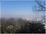
 | Trnovec - Polhograjska Grmada
Polhograjska Grmada is an 898 m high peak located in the heart of the Polhograjski Dolomites. From the summit, where there is a registration box ...
1 h 15 min |
 | Šmartno - Šmarna gora (Šmartinska way)
Šmarna gora is a 669 m peak northwest of Slovenia's capital. From the summit, with its restaurant and church, there is a beautiful view over Gore...
50 min |
 | Tacen - Šmarna gora (via Spodnja Kuhinja)
Šmarna gora is a 669 m peak northwest of Slovenia's capital. From the summit, with its restaurant and church, there is a beautiful view over Gore...
55 min |
 | Povodje - Šmarna gora
Šmarna gora is a 669 m peak northwest of Slovenia's capital. From the summit, with its restaurant and church, there is a beautiful view over Gore...
1 h 30 min |
 | Šmartno - Šmarna gora (path around Šmarna gora)
Šmarna gora is a 669 m peak northwest of Slovenia's capital. From the summit, with its restaurant and church, there is a beautiful view over Gore...
1 h 30 min |
 | Vikrče - Šmarna gora (via Zatrep)
Šmarna gora is a 669 m peak northwest of Slovenia's capital. From the summit, with its restaurant and church, there is a beautiful view over Gore...
1 h 10 min |
| Skaručna - Šmarna gora
Šmarna gora is a 669 m peak northwest of Slovenia's capital. From the summit, with its restaurant and church, there is a beautiful view over Gore...
1 h 30 min |
 | Tacen - Šmarna gora (Partizanska steza)
Šmarna gora is a 669 m peak northwest of Slovenia's capital. From the summit, with its restaurant and church, there is a beautiful view over Gore...
1 h |
| Tacen (Sveti Jurij) - Šmarna gora (Romarska pot)
Šmarna gora is a 669 m peak northwest of Slovenia's capital. From the summit, with its restaurant and church, there is a beautiful view over Gore...
1 h |
| Tacen (Sveti Jurij) - Šmarna gora (Partizanska steza)
Šmarna gora is a 669 m peak northwest of Slovenia's capital. From the summit, with its restaurant and church, there is a beautiful view over Gore...
1 h |
| Lipa - Šmarna gora (path via Peski)
Šmarna gora is a 669 m peak northwest of Slovenia's capital. From the summit, with its restaurant and church, there is a beautiful view over Gore...
55 min |
| Lipa - Šmarna gora (by road)
Šmarna gora is a 669 m peak northwest of Slovenia's capital. From the summit, with its restaurant and church, there is a beautiful view over Gore...
1 h 5 min |
 | Vikrče - Šmarna gora (Kovačeva steza)
Šmarna gora is a 669 m peak northwest of Slovenia's capital. From the summit, with its restaurant and church, there is a beautiful view over Gore...
1 h 10 min |
| Vikrče - Šmarna gora (learning trail)
Šmarna gora is a 669 m peak northwest of Slovenia's capital. From the summit, with its restaurant and church, there is a beautiful view over Gore...
1 h 20 min |
| Spodnje Pirniče - Šmarna gora (Kovačeva steza)
Šmarna gora is a 669 m peak northwest of Slovenia's capital. From the summit, with its restaurant and church, there is a beautiful view over Gore...
1 h 10 min |
| Spodnje Pirniče - Šmarna gora (learning trail)
Šmarna gora is a 669 m peak northwest of Slovenia's capital. From the summit, with its restaurant and church, there is a beautiful view over Gore...
1 h 10 min |
 | Legastja - Sveti Jakob
The Church of St. James is located on a scenic hill north of the village of Topol pri Medvodah. From the summit, which features a registration bo...
1 h 10 min |
 | Legastja - Sveti Jakob (north path)
The Church of St. James is located on a scenic hill north of the village of Topol pri Medvodah. From the summit, which features a registration bo...
1 h |
 | Rašica - Rašica (Vrh Staneta Kosca) (by road)
Vrh Staneta Kosca, better known as Rašica, is located north of Ljubljana, more precisely above the villages of Rašica and Dobeno. From the summit...
55 min |
| Rašica - Rašica (Vrh Staneta Kosca) (footpath)
Vrh Staneta Kosca, better known as Rašica, is located north of Ljubljana, more precisely above the villages of Rašica and Dobeno. From the summit...
55 min |
 | Povodje - Rašica (Vrh Staneta Kosca)
Vrh Staneta Kosca, better known as Rašica, is located north of Ljubljana, more precisely above the villages of Rašica and Dobeno. From the summit...
1 h 30 min |
 | Jablje Castle - Rašica (Vrh Staneta Kosca)
Vrh Staneta Kosca, better known as Rašica, is located north of Ljubljana, more precisely above the villages of Rašica and Dobeno. From the summit...
1 h 20 min |
| Loka - Rašica (Vrh Staneta Kosca)
Vrh Staneta Kosca, better known as Rašica, is located north of Ljubljana, more precisely above the villages of Rašica and Dobeno. From the summit...
1 h 20 min |
 | Selo pri Vodicah - Rašica (Vrh Staneta Kosca) (old path)
Vrh Staneta Kosca, better known as Rašica, is located north of Ljubljana, more precisely above the villages of Rašica and Dobeno. From the summit...
1 h 15 min |
 | Selo pri Vodicah - Rašica (Vrh Staneta Kosca) (by road)
Vrh Staneta Kosca, better known as Rašica, is located north of Ljubljana, more precisely above the villages of Rašica and Dobeno. From the summit...
1 h 20 min |
 | Selo pri Vodicah - Rašica (Vrh Staneta Kosca)
Vrh Staneta Kosca, better known as Rašica, is located north of Ljubljana, more precisely above the villages of Rašica and Dobeno. From the summit...
1 h 30 min |
 | Spodnje Dobeno - Rašica (Vrh Staneta Kosca)
Vrh Staneta Kosca, better known as Rašica, is located north of Ljubljana, more precisely above the villages of Rašica and Dobeno. From the summit...
50 min |
 | Pševo - Sveti Jošt above Kranj (Sodarjeva pot, past the chapel)
Sveti Jošt above Kranj is a hill located west of the slightly lower Šmarjetna gora. From the summit, where the Church of St Jošt stands alongside...
50 min |
 | Žlebe - Jeterbenk (via Turnice)
Jeterbenk is a 774-meter-high peak located between the Slavkov dom hut on Golo Brdo and Katarina (the village of Topol). From the summit, where t...
1 h |
 | Žlebe - Jeterbenk (on ridge)
Jeterbenk is a 774-meter-high peak located between the Slavkov dom hut on Golo Brdo and Katarina (the village of Topol). From the summit, where t...
1 h 5 min |
 | Praproče - Polhograjska Gora (Sveti Lovrenc) (gentle path)
Polhograjska Gora, also known simply as Gora or Sveti Lovrenc, is an 824 m high hill northwest of Polhov Gradec. The summit, topped by the Church...
50 min |
 | Zalog - Polhograjska Gora (Sveti Lovrenc) (gentle path)
Polhograjska Gora, also known simply as Gora or Sveti Lovrenc, is an 824 m high hill northwest of Polhov Gradec. The summit, topped by the Church...
1 h 30 min |
 | Vrzdenec - Kožljek
Kožljek is a 788 m high peak located west of Koren, more precisely above the village of Samotorica. From the summit, where there are several benc...
1 h 5 min |
 | Preval Prosca - Koreno (gentle path)
Koreno (also known as Korena) is a 729 m high hill located north of Horjul. From the summit, which features a large cross, the church of St. Moho...
1 h 15 min |
 | Preval Prosca - Koreno (steep path)
Koreno (also known as Korena) is a 729 m high hill located north of Horjul. From the summit, which features a large cross, the church of St. Moho...
1 h |
 | Horjul - Koreno (gentle path)
Koreno (also known as Korena) is a 729 m high hill located north of Horjul. From the summit, which features a large cross, the church of St. Moho...
1 h 5 min |
 | Briše - Koreno
Koreno (also known as Korena) is a 729 m high hill located north of Horjul. From the summit, which features a large cross, the church of St. Moho...
50 min |
| Horjul - Koreno (steep path)
Koreno (also known as Korena) is a 729 m high hill located north of Horjul. From the summit, which features a large cross, the church of St. Moho...
1 h |
 | Zaklanec - Koreno
Koreno (also known as Korena) is a 729 m high hill located north of Horjul. From the summit, which features a large cross, the church of St. Moho...
1 h 15 min |
 | Sora - Hom (footpath)
Hom is a 715 m high peak that rises steeply southwest of the village of Sora. From the summit, which is partly forested, there is a beautiful vie...
50 min |
 | Sora - Hom (by road)
Hom is a 715 m high peak that rises steeply southwest of the village of Sora. From the summit, which is partly forested, there is a beautiful vie...
1 h 5 min |
 | Sora - Hom (less steep path)
Hom is a 715 m high peak that rises steeply southwest of the village of Sora. From the summit, which is partly forested, there is a beautiful vie...
55 min |
 | Skalnica - Sveta Gora (by road)
Sveta Gora is known mainly among believers and locals. It is a well-known pilgrimage center above Nova Gorica. Believers come here from all over ...
1 h |
 | Skalnica - Sveta Gora (footpath)
Sveta Gora is known mainly among believers and locals. It is a well-known pilgrimage center above Nova Gorica. Believers come here from all over ...
55 min |
 | Šmartno - Grmada
Grmada is a 676-meter-high mountain located west of the much more visited Šmarna gora. From the summit, which has a small takeoff area, a beautif...
55 min |
| Tacen - Grmada (via Spodnja Kuhinja)
Grmada is a 676-meter-high mountain located west of the much more visited Šmarna gora. From the summit, which has a small takeoff area, a beautif...
1 h |
 | Vikrče - Grmada (via Zatrep)
Grmada is a 676-meter-high mountain located west of the much more visited Šmarna gora. From the summit, which has a small takeoff area, a beautif...
1 h 15 min |
 | Vikrče - Grmada (Mazijeva steza)
Grmada is a 676-meter-high mountain located west of the much more visited Šmarna gora. From the summit, which has a small takeoff area, a beautif...
1 h 5 min |
| Tacen - Grmada (Mazijeva steza)
Grmada is a 676-meter-high mountain located west of the much more visited Šmarna gora. From the summit, which has a small takeoff area, a beautif...
1 h 10 min |
| Tacen (Sveti Jurij) - Grmada
Grmada is a 676-meter-high mountain located west of the much more visited Šmarna gora. From the summit, which has a small takeoff area, a beautif...
1 h 5 min |
 | Vikrče - Grmada (Kovačeva steza)
Grmada is a 676-meter-high mountain located west of the much more visited Šmarna gora. From the summit, which has a small takeoff area, a beautif...
1 h 10 min |
 | Lipa - Grmada (path via Peski)
Grmada is a 676-meter-high mountain located west of the much more visited Šmarna gora. From the summit, which has a small takeoff area, a beautif...
1 h |
| Lipa - Grmada (by road)
Grmada is a 676-meter-high mountain located west of the much more visited Šmarna gora. From the summit, which has a small takeoff area, a beautif...
1 h 10 min |
| Vikrče - Grmada (on Kovačeva steza and over Sedlo)
Grmada is a 676-meter-high mountain located west of the much more visited Šmarna gora. From the summit, which has a small takeoff area, a beautif...
1 h 15 min |
| Vikrče - Grmada (learning trail)
Grmada is a 676-meter-high mountain located west of the much more visited Šmarna gora. From the summit, which has a small takeoff area, a beautif...
1 h 20 min |
| Spodnje Pirniče - Grmada (learning trail)
Grmada is a 676-meter-high mountain located west of the much more visited Šmarna gora. From the summit, which has a small takeoff area, a beautif...
1 h 15 min |
| Spodnje Pirniče - Grmada (on Kovačeva steza and over Sedlo)
Grmada is a 676-meter-high mountain located west of the much more visited Šmarna gora. From the summit, which has a small takeoff area, a beautif...
1 h 15 min |
 | Polhov Gradec (Blagaj Castle) - Mali vrh
West of Polhov Gradec, between the rivers Mala voda and Velika Božna, lies the 708-meter-high hill known as Mali vrh. From the grassy summit, whi...
1 h 20 min |
 | Krašnja - Limbarska gora
Limbarska gora is located northeast of Moravče. From the summit, there is a beautiful view of the surrounding peaks, and in good weather, the Kam...
1 h 15 min |
 | Moravče - Limbarska gora (via Serjuče)
Limbarska gora is located northeast of Moravče. From the summit, there is a beautiful view of the surrounding peaks, and in good weather, the Kam...
1 h 25 min |
 | Star maln - Koča na Planini nad Vrhniko
Planina nad Vrhniko is for Vrhnika locals something like Šmarna gora for those from Ljubljana. It is 733 m high, reachable by several paths from ...
1 h |
 | Stara Vrhnika - Koča na Planini nad Vrhniko (via Kuren)
Planina nad Vrhniko is for Vrhnika locals something like Šmarna gora for those from Ljubljana. It is 733 m high, reachable by several paths from ...
1 h 15 min |
| Stara Vrhnika - Koča na Planini nad Vrhniko (via Špica)
Planina nad Vrhniko is for Vrhnika locals something like Šmarna gora for those from Ljubljana. It is 733 m high, reachable by several paths from ...
1 h 15 min |
 | Moravče - Sveti Miklavž above Sava
The Church of St. Miklavž is situated on a panoramic hill south of Moravče. From the summit, there is a beautiful view toward the nearby Limbarsk...
1 h 25 min |
 | Kuren - Ulovka
Ulovka is a peak between Zaplana and Zavetišče na Planini nad Vrhniko. From the summit, to which ski lifts run, there is a nice view to the north...
50 min |
 | Preval Prosca - Ključ
Ključ is a forest-covered peak located north of the village Brezje pri Dobrovi and south of Dolenja vas. The summit, which has a stamp box with l...
1 h |
 | Dolenja vas (Kosmulj) - Ključ
Ključ is a forest-covered peak located north of the village Brezje pri Dobrovi and south of Dolenja vas. The summit, which has a stamp box with l...
1 h 10 min |
 | Sveti Urh - Ključ
Ključ is a forest-covered peak located north of the village Brezje pri Dobrovi and south of Dolenja vas. The summit, which has a stamp box with l...
1 h |
 | Podgorje - Kojnik (steep path)
Kojnik is a partly forested peak located in the southern part of Podgorski Kras near the Slovenian-Croatian border. From the summit, which has a ...
1 h |
 | Zazid - Jampršnik
Jampršnik is a little-known and even less visited peak located in the mountain chain southwest of Črni Kal. Despite its modest height, there is a...
1 h |
 | Širje - Dom v Gorah
The Dom v Gorah mountain hut is located east of Hrastnik, just a few meters below the 786 m high peak where the church of St. Jurij stands. From ...
1 h 20 min |
| Krnice - Dom v Gorah
The Dom v Gorah mountain hut is located east of Hrastnik, just a few meters below the 786 m high peak where the church of St. Jurij stands. From ...
1 h 5 min |
 | Marno - Dom v Gorah
The Dom v Gorah mountain hut is located east of Hrastnik, just a few meters below the 786 m high peak where the church of St. Jurij stands. From ...
1 h 15 min |
 | Kekec - Škabrijel
Škabrijel is a hill northeast of the town of Gorica. Since the vegetation on the summit was cleared and a tall metal observation tower was erecte...
50 min |
 | Prevala - Škabrijel (via Veliki hrib)
Škabrijel is a hill northeast of the town of Gorica. Since the vegetation on the summit was cleared and a tall metal observation tower was erecte...
1 h 5 min |
| Prevala - Škabrijel
Škabrijel is a hill northeast of the town of Gorica. Since the vegetation on the summit was cleared and a tall metal observation tower was erecte...
50 min |
| Prevala - Škabrijel (via Hungarian pyramid)
Škabrijel is a hill northeast of the town of Gorica. Since the vegetation on the summit was cleared and a tall metal observation tower was erecte...
1 h |
 | Dobrič - Gora Oljka
Gora Oljka is a hill located east of Šmartno ob Paki. On the summit stands the Church of the Holy Cross, built in the mid-18th century. Just a fe...
50 min |
 | Dobrič (Vedet) - Gora Oljka (via Brezovec)
Gora Oljka is a hill located east of Šmartno ob Paki. On the summit stands the Church of the Holy Cross, built in the mid-18th century. Just a fe...
50 min |
 | Podvin pri Polzeli - Gora Oljka (lower path)
Gora Oljka is a hill located east of Šmartno ob Paki. On the summit stands the Church of the Holy Cross, built in the mid-18th century. Just a fe...
1 h 30 min |
 | Matke - Golava
Golava is a peak located north of Mrzlica. From the summit, where there is a small bivouac (Blažev bivak), there is a fine view toward the aforem...
1 h 15 min |
 | Gora - Trstelj
Trstelj is the highest peak in the ridge of Črni hribi. From the spacious summit, which has TV transmitters, the view is divided. From the north ...
50 min |
 | Žička kartuzija - Skala
Skala is a viewpoint on the eastern part of Konjiška gora. From this vantage point, equipped with a table, bench, and logbook box, there is a nic...
1 h |
 | Mrzle doline - Sveti Peter
Sveti Peter is a partly forested peak in Suha Krajina above the village of Dvor. On the summit stands a small shelter (usually open on Sundays) a...
1 h 15 min |
 | Grad Pišece - Veliki Špiček
Veliki Špiček is the highest peak of Brežice municipality. From the top a nice view spreads towards the south and east. Most of Brežice municipal...
1 h 5 min |
 | Žlebe - Rog (via Turnice)
Rog is an 798-meter peak above the village of Topol, just 10 minutes from St. Katarina's Church. From the summit, where a large cross once stood,...
1 h 30 min |
 | Legastja - Rog
Rog is an 798-meter peak above the village of Topol, just 10 minutes from St. Katarina's Church. From the summit, where a large cross once stood,...
1 h 15 min |
 | Tržič - Kamnek (Radetzky way)
Kamnek (Kamnik on maps, also sometimes Kamnjek) is a panoramic peak above Tržič....
1 h |
 | Tržič (Slap) - Kamnek (via Ride)
Kamnek (Kamnik on maps, also sometimes Kamnjek) is a panoramic peak above Tržič....
55 min |
 | border crossing Lipica - Kokoš (steep way)
The Koča na Kokoši mountain hut is located on Jirmanec peak, just 5 minutes from the forested Kokoš. From the summit, situated south of Lokavsko ...
50 min |
| border crossing Lipica - Kokoš (by road)
The Koča na Kokoši mountain hut is located on Jirmanec peak, just 5 minutes from the forested Kokoš. From the summit, situated south of Lokavsko ...
1 h |
 | Lipica (Škibini) - Kokoš
The Koča na Kokoši mountain hut is located on Jirmanec peak, just 5 minutes from the forested Kokoš. From the summit, situated south of Lokavsko ...
50 min |
| Lokev - Kokoš
The Koča na Kokoši mountain hut is located on Jirmanec peak, just 5 minutes from the forested Kokoš. From the summit, situated south of Lokavsko ...
1 h 30 min |
 | Krvavi Potok - Kokoš
The Koča na Kokoši mountain hut is located on Jirmanec peak, just 5 minutes from the forested Kokoš. From the summit, situated south of Lokavsko ...
1 h 30 min |
| Prelože pri Lokvi - Kokoš
The Koča na Kokoši mountain hut is located on Jirmanec peak, just 5 minutes from the forested Kokoš. From the summit, situated south of Lokavsko ...
1 h 30 min |
 | Blečji vrh - Gradišče (via Kucelj)
Gradišče is a lesser-known peak situated north of Višnja gora. From the summit, where a large cross stands, there is a nice view of the surroundi...
1 h 30 min |
 | Hrpelje - Hrpeljska gora
Hrpeljska gora, also known as Mišja šoga, is a 737-meter-high peak located south of Hrpelje. From its partly vegetated summit, there are beautifu...
1 h 30 min |
 | Podgora - Kamen vrh
Kamen Vrh is a panoramic hill located on the northern edge of Mala Gora. From the summit, surrounded by low bushes, there are fine views of parts...
1 h |
 | Podpeč - Kamen vrh
Kamen Vrh is a panoramic hill located on the northern edge of Mala Gora. From the summit, surrounded by low bushes, there are fine views of parts...
50 min |
 | Velike Lašče - Kamen vrh
Kamen Vrh is a panoramic hill located on the northern edge of Mala Gora. From the summit, surrounded by low bushes, there are fine views of parts...
1 h 15 min |
 | Ortnek - Grmada on Mala gora
Grmada (also Grmada above Ortnek) is an 887-meter-high peak located above the village of Vrh pri Poljanah in the Mala Gora range. Just a few mete...
1 h |
 | Bresternica (Šoberjev dvor) - Tojzlov vrh
Tojzlov vrh is a forested hill on the eastern part of Kozjak. On the summit stands a small stone NOB monument and, more recently, also a summit l...
1 h 15 min |
 | Šober - Tojzlov vrh
Tojzlov vrh is a forested hill on the eastern part of Kozjak. On the summit stands a small stone NOB monument and, more recently, also a summit l...
1 h |
| Šober (Log) - Tojzlov vrh
Tojzlov vrh is a forested hill on the eastern part of Kozjak. On the summit stands a small stone NOB monument and, more recently, also a summit l...
50 min |
 | Mekinje nad Stično - Pristava above Stična
Pristava nad Stično is a small village on a scenic rise north of Stična. Slightly above the village near the Partizanski dom lies a broad, panora...
1 h 5 min |
 | Polhov Gradec - Visoki hrib
Visoki hrib is a 602-meter-high hill located south of Polhov Gradec. From the summit, which is partly overgrown with forest, a beautiful view ope...
1 h 15 min |
 | Hotedršica - Medvedje Brdo
Medvedje Brdo is a small settlement located north of Hotedršica. The highest point of the village is a pleasant viewpoint on Šinkovcov grič (814 ...
1 h 15 min |
 | Belica - Kregovnik
Kregovnik is a lesser-known peak on the southeastern ridge of the 898-meter-high Polhograjska Grmada. From its mostly forested summit, there are ...
1 h |
 | Ljubljanica - Sveti Andrej (Planina above Horjul)
The Church of St. Andrew stands on a panoramic hill just above Planina nad Horjulom. From the church, built in 1659, there is a beautiful view of...
1 h 15 min |
 | Preska - Sveti Florijan (Tehovec)
The Church of St. Florijan is a subsidiary church located in the village of Tehovec above Medvode. From the church, first mentioned in 1548, a ni...
1 h 15 min |
| Sora - Sveti Florijan (Tehovec)
The Church of St. Florijan is a subsidiary church located in the village of Tehovec above Medvode. From the church, first mentioned in 1548, a ni...
1 h 15 min |
 | Legastja - Sveti Florijan (Tehovec)
The Church of St. Florijan is a subsidiary church located in the village of Tehovec above Medvode. From the church, first mentioned in 1548, a ni...
50 min |
 | Kropa - Sveti Primož in Felicijan (Jamnik)
The Church of St. Primož and Felicijan at Jamnik is located on a scenic grassy ridge rising between Kropa and Podblica. From the church or its ne...
1 h 10 min |
 | Rovte - Sveti Primož in Felicijan (Jamnik)
The Church of St. Primož and Felicijan at Jamnik is located on a scenic grassy ridge rising between Kropa and Podblica. From the church or its ne...
1 h 15 min |
 | Češnjica pri Kropi - Sveti Primož in Felicijan (Jamnik)
The Church of St. Primož and Felicijan at Jamnik is located on a scenic grassy ridge rising between Kropa and Podblica. From the church or its ne...
1 h 15 min |
 | Kambreško - Globočak
Globočak is an 809 m high peak located in the Kanal Kolovrat range. From the summit, which has some remnants from the First World War, there is n...
50 min |
 | Narin - Šilentabor
Šilentabor is a 751-meter-high peak just above the village of the same name. From the summit, near which there is a bench and a logbook box, ther...
1 h |
 | Krvavi Potok - Veliko Gradišče
Veliko Gradišče is a 742-meter-high peak south of the village Lokev on the Karst and east of Kokoš. From the summit, marked by a concrete boulder...
1 h |
 | Ortnek - Sveti Gregor on Slemena
Sveti Gregor is a settlement on the panoramic Slemena. At its center stands the parish church of St. Gregory the Great, nearby a large sports fie...
1 h 10 min |
 | Log - Pečke (steep path)
Pečke is an easily accessible peak that has seen fewer visitors lately, located north of the main Pohorje ridge. It gets more visits only on May ...
1 h |
 | Bridge over Dušica - Bajturn (Zaplaški hrib) (on ridge)
Bajturn, or Zaplaški hrib, at 609 meters, is the highest peak in the Trebnje municipality. The summit features a pleasant bench with a table, a b...
1 h 20 min |
| Bridge over Dušica - Bajturn (Zaplaški hrib) (on north slope)
Bajturn, or Zaplaški hrib, at 609 meters, is the highest peak in the Trebnje municipality. The summit features a pleasant bench with a table, a b...
1 h 30 min |
| Okrog (Lazar) - Bajturn (Zaplaški hrib) (on ridge)
Bajturn, or Zaplaški hrib, at 609 meters, is the highest peak in the Trebnje municipality. The summit features a pleasant bench with a table, a b...
1 h 30 min |
 | Višnja Gora - Sveti Duh (Polževo)
The Church of the Holy Spirit is located at 630 meters above sea level on a hill above Hotel Polževo. The stamp is a few dozen meters away, along...
1 h 30 min |
 | Leše - Volinjak (via Hermanko)
Volinjak (wrongly named Volinjek on some maps) is an 886-meter-high peak located between Mežica and Prevalje. From the summit, which has a summit...
1 h 5 min |
| Leše - Volinjak (via Prapar)
Volinjak (wrongly named Volinjek on some maps) is an 886-meter-high peak located between Mežica and Prevalje. From the summit, which has a summit...
1 h 5 min |
 | Mežica - Volinjak
Volinjak (wrongly named Volinjek on some maps) is an 886-meter-high peak located between Mežica and Prevalje. From the summit, which has a summit...
1 h 10 min |
 | Gorenja vas - Jermanca (Jermancov grič)
Jermanca (Jermancov grič on maps) is a panoramic hill above Gorenja vas. In good weather, the summit offers nice views of the peaks above Poljans...
55 min |
 | Moravče - Gorišca
Gorišca is a 698-meter-high peak located southwest of the Ušte - Žerenk mountain hut. The summit, which has a transmitter, offers no good views d...
1 h 15 min |
 | Podjuna / Jaunstein - Gora svete Eme (Junska gora) / Hemmaberg (detour of closed route)
Gora sv. Eme (Junska gora) / Hemmaberg is located south of the village Podjuna / Jaunstein. On the summit stands the church of St. Ema (Hema) Krš...
55 min |
| Globasnica / Globasnitz - Gora svete Eme (Junska gora) / Hemmaberg
Gora sv. Eme (Junska gora) / Hemmaberg is located south of the village Podjuna / Jaunstein. On the summit stands the church of St. Ema (Hema) Krš...
55 min |
 | Jablance - Grmada (Bohor)
The Grmada peak is situated on the slope of Bohor. The summit offers no views but is easily accessible. A partisan hospital is nearby....
1 h 20 min |
 | Oplotnica - Brinjeva gora (above Zreče) (above quarry)
Brinjeva gora is a prominent hill situated between Zreče and Oplotnica. It is known for several churches located along its entire ridge. Several ...
1 h 30 min |
 | Oplotnica - Brinjeva gora (above Zreče) (on forest path)
Brinjeva gora is a prominent hill situated between Zreče and Oplotnica. It is known for several churches located along its entire ridge. Several ...
1 h 30 min |
 | Zreče (Terme Zreče) - Brinjeva gora (above Zreče) (via farm Pudgrošek)
Brinjeva gora is a prominent hill situated between Zreče and Oplotnica. It is known for several churches located along its entire ridge. Several ...
50 min |
 | Zreče (Terme Zreče) - Brinjeva gora (above Zreče) (via Golika)
Brinjeva gora is a prominent hill situated between Zreče and Oplotnica. It is known for several churches located along its entire ridge. Several ...
1 h |
 | Puštal (Na Dobravi) - Sveti Andrej (above Zminec)
The Church of St. Andrew is located on a panoramic hill in the Sveti Andrej settlement. From the church, there is a fine view of the Škofjeloško ...
1 h 15 min |
 | Škale - Lubela (via hunting lodge)
Lubela is a hill near Velenje that rises to the north above the Šaleška Valley and belongs to the Šentviško Hills or the broader Graška Gora area...
1 h 15 min |
 | Predgrad - Kozice
Kozice is a 741-meter-high peak with an RTV transmitter located above the left bank of the Kolpa River. From the viewpoint on the southern subpea...
1 h 15 min |
| Predgrad - Kozice (by road)
Kozice is a 741-meter-high peak with an RTV transmitter located above the left bank of the Kolpa River. From the viewpoint on the southern subpea...
1 h 30 min |
 | Zreče (Terme Zreče) - Golek
Golek is a 769-meter-high peak located northwest of Zreče. The summit has a logbook box with book and stamp, plus a bench; a short distance (a fe...
1 h 25 min |
| Zreče (Terme Zreče) - Golek (via Bork)
Golek is a 769-meter-high peak located northwest of Zreče. The summit has a logbook box with book and stamp, plus a bench; a short distance (a fe...
1 h 30 min |
| Zreče (cemetery) - Golek
Golek is a 769-meter-high peak located northwest of Zreče. The summit has a logbook box with book and stamp, plus a bench; a short distance (a fe...
1 h 15 min |
| Ljubnica - Golek (spodnja pot)
Golek is a 769-meter-high peak located northwest of Zreče. The summit has a logbook box with book and stamp, plus a bench; a short distance (a fe...
1 h 15 min |
 | Zreče (Terme Zreče) - Golika
Golika is a 609-meter-high peak on Brinjeva gora, on which stands the church of St. Neža....
50 min |
 | Bad Gleichenberg (Eichgraben Weg) - Gleichenberger Kogel (via Mühlsteinbruch)
Gleichenberger Kogel is a 598-meter-high mountain of volcanic origin located above Bad Gleichenberg in Styria....
1 h 10 min |
| Bad Gleichenberg (Eichgraben Weg) - Gleichenberger Kogel
Gleichenberger Kogel is a 598-meter-high mountain of volcanic origin located above Bad Gleichenberg in Styria....
1 h 5 min |
 | Marno - Vrhe (at Gore)
Vrhe is a forested 781-meter-high peak located northwest of the Planinski dom hut in Gore....
1 h 25 min |
 | Rein - Pfaffenkogel
Pfaffenkogel is a 734 m high hill in the western part of the Grazer Bergland in Austrian Styria. The summit is located north of the town of Gratw...
1 h 30 min |
 | Vuzenica - Sveti Janez Krstnik (Šentjanž nad Dravčami)
The Church of St. John the Baptist stands in the settlement Šentjanž nad Dravčami, situated south of Dravče and north of the Levovnik farm. From ...
1 h 25 min |
 | Vuzenica - Sveti Primož (Sveti Primož na Pohorju)
The Church of St. Primož is situated on a panoramic part of the settlement Sveti Primož na Pohorju. Slightly below the church there is a larger N...
1 h 30 min |
 | Straßengel - Generalkogel
Generalkogel (in the 19th century still called Brennkogel) is a 713-meter-high hill in the western part of the Graz Mountains in Styria.It is loc...
1 h 30 min |
 | Straßengel - Frauenkogel
Frauenkogel is a 683-meter-high hill in the western part of the Graz mountains in Steiermark.The hill is located not far northwest of Graz.On the...
1 h 10 min |
 | Lovnik - Rančka
Rančka is a 615-meter-high peak located west to southwest of Boč. Just below the summit is a stamp box with a bench nearby; the highest point its...
1 h |
| Šentjanž - Leskovški hrib
Leskovški hrib is a 721-meter peak in Posavsko hribovje above the Church of Our Lady of Sorrows in Leskovec, Podboršt. From the top there is a be...
1 h |
 | Radegunda (Žekovec) - Sveta Radegunda (Radegunda)
The Church of St. Radegunda stands on a wooded hill above the settlement of Radegunda....
1 h 15 min |
 | Donji Borki - Petrov vrh above Daruvar
Petrov vrh is one of the peaks on Papuk Mountain. It is located above the town of Daruvar and is a popular destination for local residents. There...
1 h |
 | Male Drage - Okrugljak
Okrugljak is a forested hill located in the eastern part of Gorski Kotar, near the border with Slovenia. The summit was formerly an HPO point (no...
1 h 30 min |
 | Gorjane (Železno) - Rigelj
Rigelj is a 626-meter-high indistinct peak in the Orlice range, on which a few antennas stand....
1 h 20 min |
 | Grad Pišece - Intermedija (via Velika bukva)
Intermedija is a 662-meter-high peak in the Orlica range. From the summit, there is a beautiful view mainly to the north and northeast, where on ...
1 h 5 min |